MidlothianWX
-
Posts
1,786 -
Joined
-
Last visited
Content Type
Profiles
Blogs
Forums
American Weather
Media Demo
Store
Gallery
Everything posted by MidlothianWX
-
Here is a snippet from the BOU morning AFD: I was curious if they'd bump up totals a bit after the 0z runs but it looks like they are sticking with what they've got.
-
Yeah, which validates BOU's suspicion that this system might ultimately take a slightly more southerly track than has been depicted by some of the globals.
-
It will be interesting to see what the ensembles say. I know we are very close to game-time now but BOU has said that they are creating their maps based off of ensemble blends.
-
Oh wow, the Euro QPF jump is impressive. Boulder: 12z: 2.1" 0z: 2.9" Denver: 12z: 2.1" 0z: 2.8"
-
0z para has decided to bullseye Boulder with 4.3" qpf, hah.
-
Lol. Tney get monster storms every fall and spring. We get them once a decade:( Having lived and tracked storms in the MA for ~10 years before moving here, I'll say that nothing beats a NESIS storm. That being said, 20" events are a 1 in 5 year occurrence in Boulder, which might explain the lack of action here.
-
FWIW, I've been following this guy since I moved out here and he is solid.
-
Interesting note from the NWS AFD this morning:
-
Eyeballing 0z QPF from Pivotal maps... GFS: Boulder: 3.7" Denver: 2.9" Estes: 5.2" CMC: Boulder: 3.5" Denver: 2.3" Estes: 4.0" UK: Boulder: 3.7" Denver: 3.4" Estes: 3.4" Euro (hi-res): Boulder: 2.1" Denver: 1.9" Estes: 1.8"
-
Yeah, this is kind of what I was getting at. If Wentz is fine with getting snowed in for a few days then I would go to Nederland or Estes Park for sure. Otherwise, Boulder is a safer bet.
-
Boulder is roughly a ~45 minute drive from the airport and might be your best bet for this storm, assuming you want to stay relatively close as you said. Feel free to PM me if you need any help/advice.
-
QPF-wise, the other globals are closer to the GFS than they are the Euro. Regardless, the next few model runs will be very interesting.
-
The margins have shifted but the overall qpf picture for Denver/Boulder/FoCo has remained fairly consistent. For example, for the past 4+ runs the para GFS has put 5" +/- .2" over me. This 18z run continues that trend. Likely too juiced but it has been steadfast.
-
It appears the 12z Euro increased QPF in the Denver/Boulder metro to 2-2.5". Can any local experts tell me how the Euro typically verifies in heavy upslope scenarios vs. the other globals?
-
12z GFS qpf: Boulder: 5.2" Denver: 5.0" Precip begins roughly 48 hours from now.
-
6z GFS holds serve with 5-6" of QPF from Denver north. This is a battle between the Euro and GFS/CMC/UK at this point. Morning AFD from Boulder:
-
You might be right. I could be looking at the wrong data on Pivotal. I'll leave the temp discussion to those who are more well versed in local climo.
-
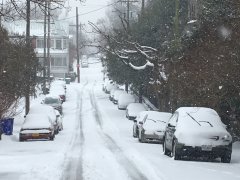
QPF totals for 0z GFS: Regular: Boulder: 7.3" Denver: 3.9" FoCo:5.0" Para: Boulder: 5.3" Denver: 4.3" FoCo: 3.5" This run seems a bit colder - I would presume this is all snow. Also, the storm keeps getting pushed back - light snow begins early Saturday, heavier stuff moves in late morning.
-
Forecast discussion from Boulder:
-
12z GFS QPF: Denver: 2.3" Boulder: 4.6" FoCo: 5.7" Seems like a pretty harsh gradient. Also, Denver and Boulder flirt with the rain/snow line briefly on Saturday.
-
The 18z GFS says, why not crank it up a bit more? Boulder: 6.3" qpf Denver: 5.6" qpf Kuchera says nearly 77" for Boulder - unreal. Definitely won't verify but it's fun to look at.
-
I love reminiscing about the 2009-10 season. I was in Richmond at the time and followed every storm very closely on these boards. My love for winter weather was sparked by PDII though - I was living in Frederick, MD at the time and we received something like 25" which is still my all-time IMBY total (followed closely by Nov '19 here in Boulder). If the 12z GFS is anywhere close to accurate though - and that is a massive "if" - I might be looking at finally breaking that record. Looks to be about 4.8" of qpf from Fri-Sun for Boulder proper. I chased Feb '13 in Boston. I want to say the final total was something like 26". Got knocked over by a wind gust, met Jim Cantore, and randomly bumped into a few AmWx members at a bar. I believe that was only the second time in history that they shut the roads down, after '78 of course.
-
Hope you all have a rockin' winter
-
-