

tamarack
-
Posts
14,665 -
Joined
-
Last visited
Content Type
Profiles
Blogs
Forums
American Weather
Media Demo
Store
Gallery
Posts posted by tamarack
-
-
On 4/1/2024 at 7:43 AM, Cold Miser said:
While some up north have a shot at a decent, final round of snow, for most of the forum winter weather is finished...For me, it was finished in mid-February, as the season went out with a bang, pounding me with an entire 1"...I think from a cold squall line.
The grades (all items are equally weighted)
Overall Seasonal Snowfall: F
Picking up where I left off last season, I ended up with another meager, seasonal total...15", which was only 4" more than last winter's disaster.
Snow vs. Rain: F
Rain was king
Staying power/ (number of days) of pack: D-
What little "Pack" that I had did manage to hang around a bit.
Local winter enjoyment: F
Temperature: C
Cold was there, but just not at the right time.
Snowstorms/ events (quality/ quantity): F
My biggest event was under 6"...Not even nude-worthy.Overall Grade: F
Again, a failure of a season, my second full year at Lava Lake, but I'm sure the "so much potential" crew will chime in.Surprised at the C for temps. Here it was the mildest DJF and DJFM of 26 cold seasons. Pack was mediocre but the coming snowstorm will almost certainly push the total into AN territory, possibly well into AN.
-
57 minutes ago, dendrite said:
I’d argue those were my strongest prolonged winds since moving here. Coop door almost blew off. Blizzard conditions with the lgt/mod snow and BLSN.
Probably the strongest blizzard winds I've seen since April 1982 in Fort Kent. Our rescue Lab mix from TX, who had arrived here on Feb 4, was utterly terrified. However, the strongest sustained winds here were last Dec 18th; probably blew down at least 5 times as many fir as any other event here.
-
1 minute ago, ORH_wxman said:
You might get two 20-burger storms inside of 2 weeks after the equinox. Not bad.
Only 1960-61 (NNJ) and 2016-17 have had a pair of 20s. Already notched our biggest March storm, would need to top the 18.5" of 4-5/07 to crack April as well.
-
21 minutes ago, dryslot said:
If it’s right, Close to it.
Shooting for 100 here. Could be close.
-
 2
2
-
-
18 hours ago, Brian5671 said:
Morch finished +5.2 at BDR. And that's after a cooler last 10 days lol
Numbers for a weird March:
Avg max: 40.9 +2.1 6th mildest Mildest: 51 on the 6th
Avg min: 24.3 +7.5 Mildest min of 26. Coldest: 4 on th 1st
Avg mean: 32.6 +4.8 3rd mildest. The avg diurnal range is 2.1° less than 2nd least.
Streaky temps.
1st was BN,
2-20 all AN,
21-26 BN,
27-31 AN.
Avg for 2-20: +9.6 (Min avg +12.4)
Precip: 8.67" +4.99 Tops by 0.76" Wettest day: 1.53" on the 10thSnow: 29.3" +11.9" Snowiest day: 11.5" on the 23rd. The 22.0" of 3/23-24 is March's biggest and tied with Dec 16-18 for 3rd biggest.
Pack avg: 5.3", well below avg but the 22" O.G. at 7 on the 24th is tops for the snow season.-
2
-
-
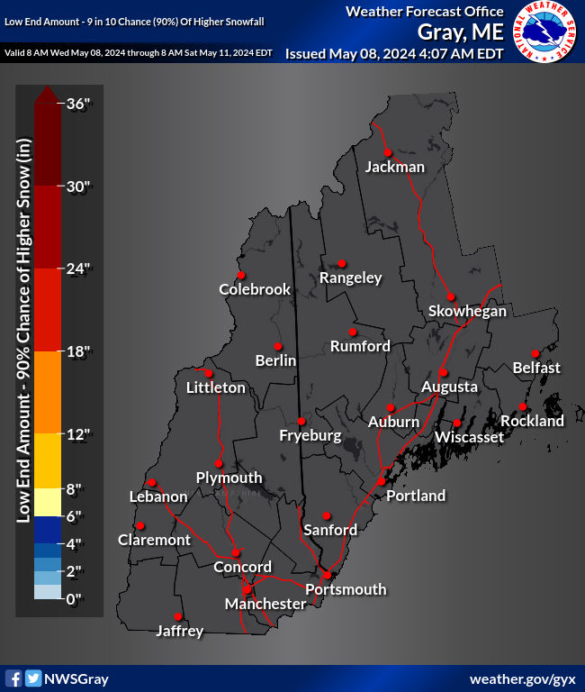
GYX is bullish this morning, especially for the foothills along the Maine/NH boundary.
ocation Snow Amount Potential Chance of Seeing More Snow Than Low End
SnowfallExpected
SnowfallHigh End
Snowfall>=0.1" >=1" >=2" >=4" >=6" >=8" >=12" >=18" Portland, ME 0 3 14 87% 83% 77% 65% 53% 42% 23% 7% Brunswick, ME 2 9 17 93% 91% 88% 80% 70% 58% 34% 10% Cumberland Center, ME 4 11 20 95% 94% 91% 86% 78% 69% 47% 19% Gray, ME 9 15 24 99% 99% 99% 97% 94% 90% 73% 38% Bridgton, ME 13 19 27 100% 100% 100% 100% 99% 97% 90% 60% Lewiston, ME 10 16 23 100% 100% 99% 99% 97% 93% 78% 40% Augusta, ME 8 14 19 100% 99% 99% 97% 94% 87% 62% 18% Waterville, ME 7 12 18 100% 99% 99% 96% 91% 81% 51% 12% Fryeburg, ME 13 19 28 100% 100% 100% 100% 99% 98% 92% 66% Rumford, ME 11 17 26 100% 100% 100% 99% 98% 95% 84% 52% Farmington, ME 10 17 25 100% 99% 99% 98% 96% 92% 79% 46% Rangeley, ME 8 14 23 99% 99% 99% 97% 93% 88% 70% 35% Kingfield, ME 9 16 25 99% 99% 98% 97% 94% 90% 75% 44% Eustis, ME 7 13 23 99% 99% 98% 95% 91% 85% 65% 32% Jackman, ME 5 10 19 98% 97% 95% 90% 82% 71% 46% 16% Skowhegan, ME 7 12 19 99% 99% 98% 95% 90% 82% 57% 18% Belfast, ME 6 11 17 99% 99% 98% 94% 87% 75% 43% 9% Unity, ME 7 12 18 99% 99% 98% 95% 90% 80% 50% 11% Sanford, ME 7 10 21 100% 100% 99% 98% 94% 86% 61% 28% Kennebunk, ME 0 4 14 86% 82% 76% 64% 52% 41% 22% 7% Bath, ME 0 6 14 88% 84% 79% 68% 56% 43% 21% 5% Wiscasset, ME 4 10 17 98% 96% 94% 89% 79% 67% 40% 11% Rockland, ME <1 8 13 89% 86% 81% 71% 58% 44% 19% 2% Hope, ME 7 13 19 100% 99% 99% 96% 92% 84% 57% 16% Manchester, NH <1 2 13 91% 86% 79% 65% 52% 40% 21% 6% Nashua, NH 0 <1 11 77% 71% 65% 52% 40% 30% 15% 4% Concord, NH 3 4 14 100% 99% 97% 84% 67% 51% 26% 6% New London, NH 9 12 19 100% 100% 100% 99% 97% 91% 62% 18% Portsmouth, NH 0 <1 9 67% 60% 53% 39% 28% 18% 7% 1% Hampton, NH 0 <1 9 66% 59% 52% 38% 26% 17% 6% 1% Keene, NH 2 3 11 98% 94% 87% 68% 50% 35% 13% 2% Rochester, NH 4 6 18 100% 99% 97% 90% 78% 65% 41% 16% North Conway, NH 14 20 29 100% 100% 100% 100% 100% 99% 95% 71% Laconia, NH 8 11 19 100% 100% 100% 100% 98% 91% 61% 20% Claremont, NH 6 6 14 100% 100% 100% 99% 85% 64% 29% 5% Lebanon, NH 6 7 14 100% 100% 100% 98% 86% 64% 27% 4% Plymouth, NH 9 10 17 100% 100% 100% 100% 100% 95% 55% 11% Pittsburg, NH 4 7 14 99% 98% 96% 88% 73% 55% 23% 3% Berlin, NH 9 15 22 100% 100% 100% 99% 97% 92% 74% 32% Lancaster, NH 5 7 13 100% 100% 100% 96% 83% 61% 24% 2%
-
2
-
-
Numbers for a weird March:
Avg max: 40.9 +2.1 6th mildest Mildest: 51 on the 6th
Avg min: 24.3 +7.5 Mildest min of 26. Coldest: 4 on th 1st
Avg mean: 32.6 +4.8 3rd mildest. The avg diurnal range is 2.1° less than 2nd least.
Streaky temps.
1st was BN,
2-20 all AN,
21-26 BN,
27-31 AN.
Avg for 2-20: +9.6 (Min avg +12.4)
Precip: 8.67" +4.99 Tops by 0.76" Wettest day: 1.53" on the 10thSnow: 29.3" +11.9" Snowiest day: 11.5" on the 23rd. The 22.0" of 3/23-24 is March's biggest and tied with Dec 16-18 for 3rd biggest.
Pack avg: 5.3", well below avg but the 22" O.G. at 7 on the 24th is tops for the snow season.-
1
-
-
39 minutes ago, 40/70 Benchmark said:
My record is 8" snow/sleet combo in VD Day 2007.
Wow! I've never seen more than 3", twice in NNJ. The 2nd time was in Jan 1964 and it was topped by 1/2" ZR. Kids were skating in their back yards on the impenetrable stuff.
-
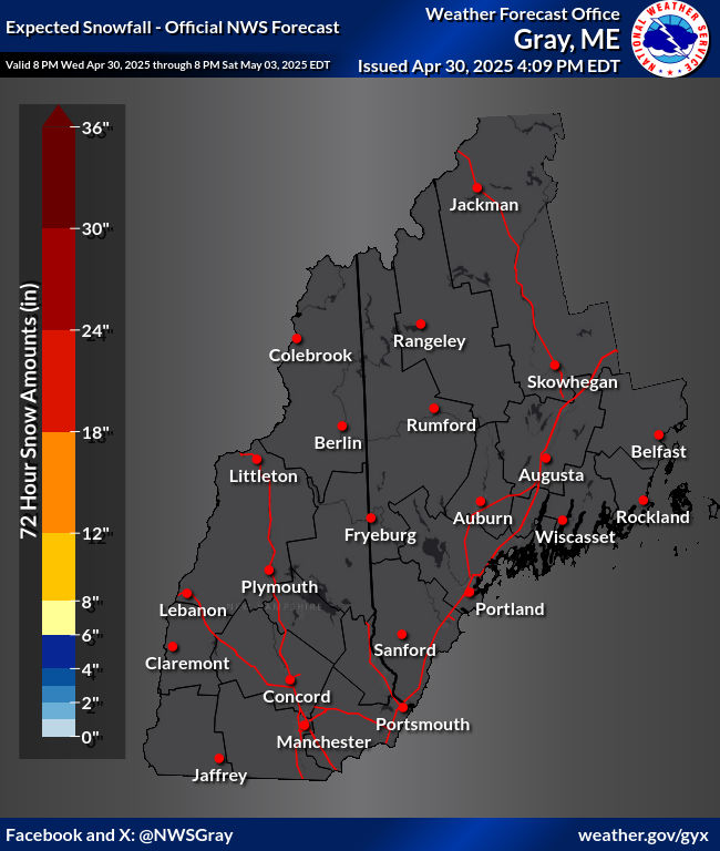
3 hours ago, dryslot said:

The spreads in the GYX snowfall predictions are huge - 90%/expected/10% for Farmington are 4/8/20. MHT <1/4/13. Lots of uncertainty still.
-
36 minutes ago, powderfreak said:
Agreed. 1,000ft is good but the lower elevations have had numerous storms where depth change nailed it pretty good. Especially up here with valley vs mountain ratios.
This last event had little elevational variation in snowfall, which is odd for a late season storm though 2m temps were well below 32. (Highest spot had somewhat greater ratio, however.)
Listed by higher/lower elevation:
Temple 1.8W 1,224' 2.02" 22.1"
Farmington 4.2NW 616' N/A 21.1"
Farmington 4.8NNW 610' 2.14" 20.5"
New Sharon 2.0N 392' 2.27" 22.0" Had 2.5 hours of sleety/rimey stuff before the death band. Don't know if the others had the same but friends in the area had some. -
1 hour ago, dryslot said:
No clue.
LEW co-op shows 7.5" for mid-April 1933, and 25.5" for the 1982 blizzard. Only CAR's 26.3" was greater, at least any I've found in Maine. Farmington measured a mere 10", the lowest that I've found in Maine for the 1982 event. I "measured" 17.0" in the Violette Settlement, the quotes because - what do you do when a major blizzard ends with 2" lower pack than pre-storm and most of the snow fell with temps low-mid teens? Guesstimate is an understatement. The drifts within 20 feet of the stake - on both sides - looked to be 5' or higher. Fort Kent co-op recorded 12" but they seem to record snowfall by how much the pack has changed.
-
2
-
-
4 hours ago, kdxken said:
Stumbled across these photos of the 1936 Hartford flood while looking for something else.
High quality photos.
https://credo.library.umass.edu/search?q=*&fq=FacetCollectionID:mums830
That was the 2nd greatest peak flow on the Sandy River until December 18 kicked it into 3rd. April 1987 still #1 by a large margin.
Measured exactly 1.00" for the 24 hr ending at 7 this morning. Both December and March are the wettest since we moved here 26 years ago, with the driest February in between. 24.40" since December 1, can't keep up with SNE however.
-
1
-
-
15 hours ago, Sey-Mour Snow said:
Lol well to be fair like 90% of News Englands population is in SNE. Edit just checked 79% of New Englands population is in SNE.
And 72% of the area is in NNE. SNE's population density is about 10X that of NNE.
-
2
-
-
44 minutes ago, Sn0waddict said:
Let’s do this instead lol

Grandkids planting the garden in SNJ (they're about 10 miles south of "79") while we sit under the clouds hoping to reach 50.
-
1
-
-
1 hour ago, Typhoon Tip said:
I think it's interesting that we've had about 9 consecutive months of above normal precipitation - I think? - on a regional scale, yet we never seem to really push the flood threat over the top. We're getting the Headlines out of the official offices but it seems by and large we're in a kind of "hydrostatic balance" (sloppy usage) where the outflow and inflow into the geography are in equilibrium; above climo, but below flood gauges.
Playin' with fire? It's like sustaining a primed wick and never getting a match event
April 2023 thru March 2024 is currently (thru 7 AM) at 63.52". 2005 had 66.67", hopefully out of reach, but #2, 63.73" will be left in the mud (no dust here). However, Feb 24 failed to get the message - its 0.95" is the driest.
-
1 hour ago, dendrite said:
Thankfully the NAM busted. Looks like the back edge of the heaviest is pushing through W NH now. Only 0.71” so far with maybe another quarter inch or so to go.
Of course, we do it again tonight.

-
44 minutes ago, HoarfrostHubb said:
May 1977 enters the chat
Where it was 10-20" it's the Octobomb, spring version, but 5/77 affected a relatively small area. I'd compare it to the BGR to MLT blizzard of Dec 30-31, 1962. In that area it might've been as powerful a blizzard as 3/1888, but in a much smaller area.
-
1
-
-
53 minutes ago, ma blizzard said:
Def could happen again not disputing that .. its just something that happens probably once every 200/300 years ..
IMO, 4/82 is nearly as anomalous as 3/1888 and 9/1938, and equal or beyond with the Octobomb and Jan 1998. (This latter may not have been the absolute most severe of anywhere, but its massive areal severe extent may be 2nd to none.)
Sun making a weak attempt to break thru the clouds, but the overall warmth has settled the pack from 15" to 10, and thoroughly ripened it.
-
2
-
-
3 hours ago, dendrite said:
CAR is at 82”
Which is 24.5" BN thru 3/26. I'm currently 3.1" ahead of them, which is unusual.
In 2000-01 we finished 5.0" ahead thanks to 55.5" in March. Ten years later we squeaked ahead by 0.2" after the 15.1" dump on April Fool's day. The 26-winter difference leaves my place averaging 33" behind CAR.Edit: Most of the above clowns would be quite frustrating here if they verified ("slim chance" is understatement). Seeing 20s and 30s barely 100 miles to the SW while we might reach 3" - even in April that would hurt, worse than 2016 when many SNE points had 5-10" of cold pow while we had cold clouds as the snow season finished 4" below the 2nd worst.
-
Later news is that the ship's rudder became useless, they called a "mayday", and the bridge was almost completely emptied, only 8 persons on it (maintenance workers?) with 2 rescued and 6 missing. If that's true, it could've been much worse.
The Army COE is to be tasked to help on the rebuild but it'll still take a long time (a year plus?) before it's replaced. Pres. Biden said that the government (us) will pay for the rebuild rather than waiting while trying to get the shipping company to pay, though I could see a concurrent attempt being made.-
2
-
-
3 hours ago, 40/70 Benchmark said:
December and February killed me in terms of temps, but the month that really killed my snowfall totals was February....I needed an escape from the MC that month and instead it happened in late March. I expected this pattern to come a month ago.
Not just temps but precip, which has been wildly anomalous December on.
DEC: 9.35" Wettest by 1.50" (26 year POR here)
JAN: 5.47" 0.54" below the wettest (1999)
FEB: 0.95" Driest
MAR: 7.41" 0.50" below the wettest (also 1999) but likely to finish on top.
-
2
-
-
14 hours ago, 40/70 Benchmark said:
I'm an amateur...which implicitly makes learning my primary motive for doing this. You can't learn from errors unless you own and accept them....only cheating myself if I don't.
Heard this many years ago:
What's the secret of business success? Right decisions.
How does one learn to make right decisions? Experience.
How does one get experience? Wrong decisions.
-
5
-
-
3 hours ago, SJonesWX said:
why the f__k would terrorists take out a bridge in the middle of the night when there are so few vehicles on it? usually their goal is to terrorize-meaning kill lots of people. this isn't that
News said that the harbor pilot reported the loss of propulsion in time to have the bridge access blocked, though some vehicles were caught in the middle. Also, ships often head out with the tide, so the ship's speed would've remained relatively high.
-
29 minutes ago, ORH_wxman said:
I think we only cracked freezing twice in January 2009....sneaky frigid month. Never hit 40F. Throw in 25" of snow from multiple events (in addition to the late December snows) and it was quite a stretch. Pack got pretty deep but not like 2011, 2013, or 2015 levels.
We reached 31° on 3 different days that month but never got higher. 16th-17th had lows of -36/-34, the 2 coldest mornings in our 26 winters here. (And Big Black River in the far NW hit -50 for a new state record.) Then February had 33" from storms of 8.5" and 24.5" 19th-23rd, briefly raising the pack to 51", though it had settled to 49 by my 9 PM obs time.

Significant Miller B Nor'easter Apr 3rd-4th OBS
in New England
Posted
Looks like something by Jackson Pollack.
Near 40 here with a raw breeze.