

tamarack
-
Posts
14,665 -
Joined
-
Last visited
Content Type
Profiles
Blogs
Forums
American Weather
Media Demo
Store
Gallery
Posts posted by tamarack
-
-
Modest 1.16" yesterday but snowmelt and saturated ground allowed the Sandy River to reach 20,900 cfs, a bit under flood flow but in the top quartile of peaks since records began in 1929. Also not quite half the peak on Dec 19 but high enough to further traumatize those suffering damage back then.
Wood frogs started "quacking" in the old stock pond last evening, appropriate as I flushed 2 hooded mergansers earlier in the day - first ducks I've ever seen on the small (30 ft diam) puddle. -
1 hour ago, OceanStWx said:
Two feet after the equinox to claw my way to normal snowfall. Just how you draw it up in the pre-winter meetings.
Spring snow elevated my total from ratter to 110% of average. Snowiest post-equinox years:
2024: 40.9"
1982: 38.6" (Fort Kent)
2007: 37.9"
2001: 35.6"
No others approached 30".-
 4
4
-
-
20 minutes ago, MaineJayhawk said:
As compelling as that is, I am putting the snowblower away for the season over the weekend
I'll soon challenge the snow by turning ash logs to firewood after their 2 winters of adding traction to the Ranger.
-
4
-
-
17 hours ago, ariof said:
I'm sort of wondering about your strategy, but it sounds like you probably didn't hit the road until 1700 or so.
From Eustis at least I wonder if the optimal route would have been to get to Kingfield and then take 142 down to 156. There are enough branching roads south of there that it may have been possible to do so. The whole idea here was to avoid converging roadways (especially if you were on the secondary road in a merge) and seek out branches, and where possible think about three steps ahead of the average driver (one step ahead = taking the parallel road to the interstate, two steps ahead is a different route, three steps ahead is a parallel road to a different route). Get beyond what can be solved algorithmically, use intuition. Google is not smart enough to predict where there will be backups 30 minutes after totality ends. Try to figure that out, and go elsewhere!
It was 6:15 PM before I cleared Kingfield, but south of there it was clear sailing. The road itself is much better than the twisting 142/156 and the latter goes near downtown Wilton, with stop signs, etc. Might've gotten some cars with folks who climbed Tumbledown, too. Of course, I ducked around Farmington and drove thru Industry instead. My wife and friend tried Town Farm Road rather than Main Street as they went back to the friend's house near the Fairbanks Bridge over the Sandy. Neither way was fun, as those coming down Rt 4 from Rangeley were diverted onto Town Farm while the "Loaf traffic went thru town.
Decent article describing the event, and traffic, on the local online news: dailybulldog.com . Some nice pics, too, including one taken from the obs platform atop Oquossoc Bald, showing folks on the ground below. The article noted 2,500+ at Saddleback and 10k+ at Sugarloaf, where the access road was closed to additional cars by 8:30 Monday morning.
re: aurora. We saw this several times when we lived in Fort Kent, usually when it was about -20.
-
1
-
-
47 minutes ago, SJonesWX said:
I am surprised that you are enjoying the new climate regime that brought you snow in late march and early April.
40.9" after the equinox, most I've measured anywhere. Another 3-day rain incoming here, though next week has more promise.
-
1
-
-
17 minutes ago, weathafella said:
Spain. I think Iceland has a much higher cloud possibility.
We were there in August 2017 and never saw full sun. Never felt temps above 60 nor calm winds, and we never got more than 40 miles from Reykjavik. Up at 66 North it's likely to be colder and cloudier.
-
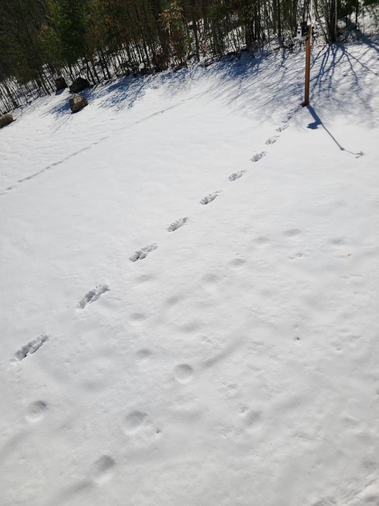
On 4/8/2024 at 5:57 PM, Lava Rock said:
Saw these tracks across the lawn. I assume moose?

Sent from my SM-G981U1 using Tapatalk
Moose tracks would be closer to round. That almost looks like a big male fisher's tracks. Most of the mustelids have that one-foot-forward tracks like the pic appears, but I don't know the exact scale.
-
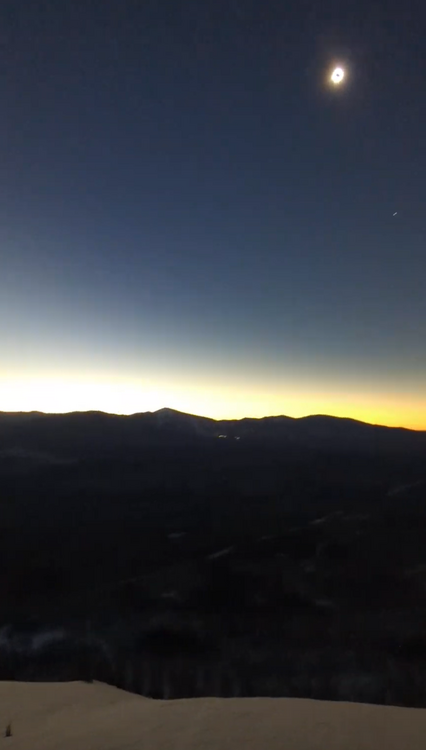
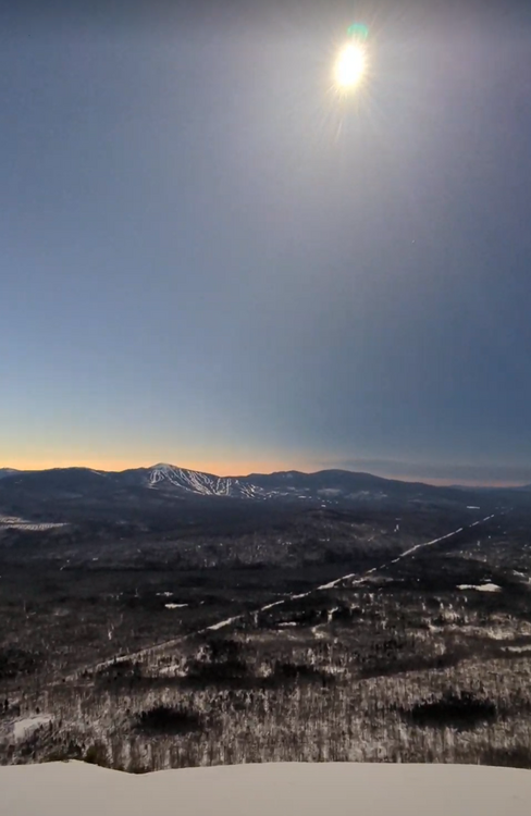
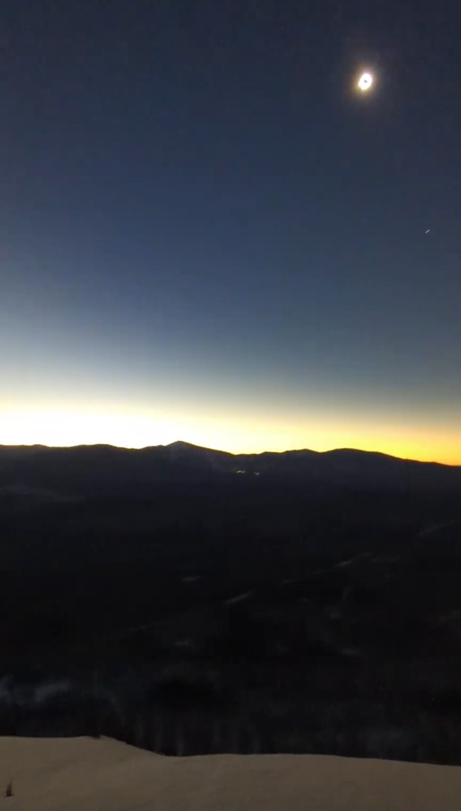
As others mentioned, the comradeship was a bonus to the event. It started for me days earlier with the back-and-forth PMs to Angus - really pleased at how it worked out for their party. We were only 6 at our viewing spot and the younger couple stayed mostly to themselves. The other 3, a 40s-ish couple and the father of one of them, were eager to chat. In the 30-minute run-up to totality we found many commonalities. They were from New Gloucester, Maine, and noted the great X-C trails at Pineland Farms, where I used to do forest management on Parks and Lands ownership, and Opportunity Farms, where I helped take down the firetower, much of which is an observation tower on Oquossoc Bald, between Rangeley and Mooselook Lakes. They also had been to the Fort Kent/Madawaska area, where we lived 1976-85.
We didn't note the sharp cooldown though there came a cool breeze during totality. I'd guess the temp drop was closer to 5°, perhaps due to the 2-foot pack remaining up there that tempered the 60+ warmth farther south.
-
2
-
-
On 4/9/2024 at 11:09 AM, Angus said:
at the recommendation of @tamarack climbed Little Bigelow Mountain which looks south and west towards Sugarloaf and the Crockers. Excellent choice and thank you so much. There was something like 3 dozen people up there with my party of six including two guys from Franklin county search and rescue who stayed up and were going to do a sweep after everyone had gone down. They also packed out the trail on Sunday which was pretty awesome. We got up about an hour before totality and everyone was in a festive mood - families, some students, a large crew from Ashbury Park NJ??? Watching the darkness move across the valley floor towards us was pretty spectacular. The winds really increased substantially and it got very cool. Just an awesome experience. Traffic getting through Madison and Norridgewock was hilarious - to experience a one mile backup in those towns is a once in a lifetime experience too! Route 16/27 and the area around Sugarloaf access road was all time from what I have been told. Without and with light!
Great report! What a wonderful 'Mainiac' deed having the almost 3 miles/1,800' gain packed out ahead of time (longer if the 0.8 miles of the county road from LFD wasn't plowed). In my PM I asked where you were at totality, here answered, as the noted road/locales made little sense to me - from my place in New Sharon I go 134 (Starks Road) to 16 to Long Falls Dam, as we're 2 towns west from Norridgewock. I guess you drove 295 to the Belgrade exit (112) then 27/back on US 2/201/16/LFD.
I drove up some 10 miles beyond Eustis - actually more as I looked (5 more miles) for a safe place to turn around on the twisty highway with narrow shoulders - and parked at the mouth of a plowed gravel road 61 miles from home. On the 1:15-3:00 drive on 27, I encountered relatively few cars (most went long earlier, except for 2 places. The hill immediately north of the Sugarloaf entry had cars parked on both sides, though 2 semis were able to meet, carefully. Where the South Branch of the Dead River enters Flagstaff Lake there is a 1/3-mile stretch with long views both east and west, and for perhaps 1/2 mile both sides had cars. Here LEOs were keeping traffic moving slowly as there were many folks walking between the parked cars.
At my stop (The "N Road"?) there were 2 other cars, 5 other people and I saw the show from about half obscured to perhaps 2:30 of totality - great show, with Venus and Jupiter in display, though the skies were still blue/gray. The only black was the moon. We also could detect the mountains and valleys of the moon, as the valleys allowed a bit brighter corona to be seen.Heading back, I knew the 2 choke points would slow things down, especially at Sugarloaf where deputies were alternating strings of cars on 27 with those exiting Sugarloaf. To my dismay, traffic remained slow for the 15 miles to Kingfield, then suddenly became wide open. 32 miles from viewpoint to Kingfield took 2.5 hours, then 29 from there to home, 45 minutes.
-
1
-
-
8 hours ago, Saguaro said:
Got into Portland from Phoenix late Saturday night. Original plans were for southern TX but I pulled the plug on those Thursday/Friday. The departing storm was still spitting out snow from around 7k feet all the way down to around 900ft in PWM area where it changed to rain showers the rest of the descent. A pretty big difference from the 70s and 80s we've been getting in AZ. The snowcover is melting rapidly, already down to patches, hard to believe 18" fell a few days ago.
Starting from Harrison tomorrow morning and am thinking Norton, Canaan, Colebrook, Pittsburg or maybe Newport. Eustis to QC border area is a possibility too.
I may be looking there as well, but even though I'm familiar with the roads there, the paucity of off-road parking may be an issue. Maybe Natanis Point Camps (north end of Natanis Pond) opened early, but if so, they're probably filled up.
-
13 hours ago, Weathernoob335 said:
Very spotty on my drive to eclipse totality zone in Maine too, finally seeing some decent snowpack north of jay, figured southern Maine would have more snow but just coatings and thats melting fast
Will go to patches (trace) today, 14" gone in 4 days. Back in the '60s, crooner Johnny Mathis did a song with the line, "Melt my heart like April snow." Outside of my Fort Kent days, snow in April has had no staying power. Even April of 2007, with 37.2" and temps 6° BN thru the 17th, saw everything gone 5 days later.
-
2 hours ago, wx_observer said:
If this info is correct, 2023 was the 4th wettest on record in Worcester. If we keep up the same rate we've had so far in 2024, we would probably surpass that.
https://www.extremeweatherwatch.com/cities/worcester/year-2023
The Kennebec drainage has had much if its top-5 peak flows in recent years, especially the 2 rivers from the mountains. All flow numbers are cfs. (Parentheses: sq. mi. watershed)
Carrabassett 1926 on (373) Much the flashiest trib.
50,700 4/1/1987
39,000 12/18/2023*
35,500 5/1/2023
31,600 8/29/2011 Irene
30,800 3/19/1936Sandy 1929 on (516)
51,100 4/1/1987
42,700 12/19/2023
38,600 3/19/1936
36,900 3/28/1953
31,300 5/1/2023Kennebec 1979 on (5,403)
232,000 4/2/1987 **
167,000 12/19/2023
113,000 6/1/1984
113,000 5/1/2023
111,000 4/28/1979
* Reached 39,000 while still rising, then went offline for 8 hours, by which time the flow was much lower.
** Greatest flow in Maine records. Comparison with Maine's other major rivers:
Penobscot, 1902 on 153,000 on 5/1/1923 (6,6721)
Saint John, 1927 on 183,000 on 4/30/2008 (5,680)
Androscoggin, 1929 on 135,000 on 3/20/1936 (3,263)-
1
-
-
1 hour ago, dryslot said:
-RN, 38/34°F, Still have bands backing in from the east with the low out by Machias.
Radar says it's raining here but the only drops I see are coming from the melting snow on the roof. Branches are dry as well. Upper 30s with high RH so evaporation shouldn't be eating all the rainfall.
-
The only quake I've felt was when we lived in Fort Kent. Epicenter was in New Brunswick, a couple dozen miles north from Fredericton, and had a 5.7 magnitude. 5+ effects were noted as far west as Allagash and to the southwest, Belfast. It was a sleep-in Saturday but at 7:41 we were rudely awakened. At 4:41 the following Monday there was a 5.4 aftershock. I was driving home from work and the bumpy roads prevented my noting it, but my wife had pots and pans rattling in our kitchen. We read of several fire depts being called for possible chimney fires on the 9th, as the quake's rumbling sounded something like well-established fire within the flue.
We saw some cracks in our foundation ("daylight basement" with only the uphill section had full height concrete) but we weren't aware of the consequences until mid-April 1983. We were traveling out of state and had house-sitters, relatives of our off-grid friends, staying at our place. There was a 3.5" deluge plus snowmelt, and they ended up bailing water out the basement's back door.
-
1
-
-
3 minutes ago, Ginx snewx said:
Yea I lived that one starting on the back of a Jon boat a mile up river on opening day. Forecast down in SRI was rain in the afternoon. Yea it started raining a little then an explosion of Dendrites. To add to the angst the trolling motor shit the bed and we were downstream mile from any semblance of road. We had 3 inches of snow on the boat by the time we rowed back, soaked, hypothermic but had some nice frozen brookies. Anyways yea great for SNE but I was wondering about NNE
I can't recall seeing another snowstorm that clobbered CHI, NYC and CAR. Must be a rare trifecta.
-
18 minutes ago, Angus said:
I was living in Waterville and I have no recollection of this storm. It's kind of strange. I remember running I think the day after the Boston Marathon either in '82 or '83 in heavy snow - somewhere across the river in Winslow.
1983. NYC posted a WSW but had only 0.8" while across the Hudson EWR recorded 4.1". Some spots in NW NJ had nearly a foot.
-
24 minutes ago, OceanStWx said:

1982 wasn't bad. Little lighter for BTV, much bigger for SNE.
Much different character, too. Dry cold pow with temps one might expect in a January blizzard - numerous low max records were set. Down at NYC it was the most wintry April snowstorm in their 155-year POR. (Embarrassing for the mets at CAR as well. Like almost everyone, they expected a sharp right turn OTS and were forecasting cold/windy/flurries. Instead, they got 26.3", at the time their biggest on record.)
-
2
-
-
34 minutes ago, OceanStWx said:

Listen, no snow forecast is ever going to be perfect in all locations, but this is going to be a pretty great forecast for a difficult April storm. We'll see what the map looks like later today (though our phones are down, so we may have to delay until we can talk to all the Coops, etc), but I think it's going to look pretty good compared to even our Tuesday maps.
Forecasts pegged the jack area essentially perfectly and did well elsewhere. Once the S+ ended before 7 yesterday morning, I figured that the forecast for here (12-18) would bust, but the wet 0.7" (0.11" LE) pushed the storm total to 13.2" - another score. It's our 3rd greatest April snow here (18.5" on 4-5/07; 15.1" on 1-2/11) and 4th anywhere (17.0" on 7-8/82 in Fort Kent). Spring total of 40.2" tops the 37.9" in 2007, a mark I thought to be unbeatable.
-
5
-
-
Probably up to 10" by now. Had 8" midnight-7 AM then maybe 1/2" 7-noon as snow was light or "is anything falling?" levels. Light-moderate at present (2:45), temp 31, gusts into the 20s. 50/50 chance of reaching the 12-18 forecast, but only the 4th double-digit storm in our 26 Aprils.
-
1
-
-
2 minutes ago, dryslot said:
Yes, But i was referring to last weeks, This will have prolonged outages too.
This is what I thought to which you were responding. (Boldface mine). DirecTV is down - probably the dish on the roof is packed but I'm not interested in climbing up there atm. Also waiting to see the plow before I run the blower, and unless we get into the good bands, I may wait until late afternoon. My machine is a bit under powered, but it will handle 10-12" okay.
gonna be days w/out power. Dec storm we were out nearly 3 days.
And those were localized outages, This is widespread.
-
1
-
-
35 minutes ago, dryslot said:
And those were localized outages, This is widespread.
Didn't CMP outages reach 400k on Dec 18? Nobody in our general region had power; we ran the genny just over 100 hours.
Had 8.5" and 0.87" LE by 7 AM, maybe 1/2" since as a stripe of nothing from the NH line to Newport was parked along Rt 2 for several hours. It's moved a bit north but still only light SN here, with occasional gusts approaching 30. Trees are loaded up to about 30 feet then wind-emptied above there. May yet reach the low end of the 12-18 forecast.
-
1
-
-
1 hour ago, dryslot said:
A bit easier reading the colors on this map.........

>30" for Saddleback and Sugarloaf.
-
GYX table of 90%/expected/10% still shows lots of uncertainty:
PWM #: 0/6/20
ASH #: >1/5/16
Less of a spread at Farmington: 13/18/25.
-
7 minutes ago, Lava Rock said:
lol, imagine if this were on monday with the eclipse. some areas up north don't have any rooms
If that were the case, there might be plenty of rooms due to all the cancellations.


April 2024 Disco- SNE’s favorite month
in New England
Posted
6/9/53 in ORH was EF4 and there are arguments (from observed damage) that it was a 5.