

tamarack
-
Posts
14,679 -
Joined
-
Last visited
Content Type
Profiles
Blogs
Forums
American Weather
Media Demo
Store
Gallery
Posts posted by tamarack
-
-
14 minutes ago, kdxken said:
I didn't know you were so close to Belgrade lakes. The views from the golf course are spectacular.
Aroostook lake is frozen but not quite ready for trucks . From last week,
"I was standing there screaming at him to stop when he headed out,” Perkins said Monday via Facebook message. “We watched him walk out with [an ice chisel] and he chipped a hole in about five hits. [We] figured he was going to walk out and fish. All of a sudden he came flying out with the truck and down he went."
9.7 miles from my snow stake to the northwesternmost cove of Great Pond, but to my SE, not south.
-
 1
1
-
-
3 hours ago, qg_omega said:
Real lakes, not ponds
I think that 75,000-acre "pond" north of Greenville might be frozen over.
Maine waterbody nomenclature is a bit different. Growing up in NNJ, we lived 100 yards from a 50-acre "lake", where I did most of my very frequent fishing. Ten miles south of my current residence lies a 9,000-acre "pond". At least it's named "Great Pond", largest of the Belgrade Lakes.
-
1
-
-
After 3 straight crummy winters, 22-23 and this season might be the "new" climate for our area: Solidly AN temps (and even moreso for precip), SN avg to AN but low ratios and frequent snow-to-rain events.
-
1
-
 1
1
-
-
40 minutes ago, WinterWolf said:
If the county does decent…that will be enough for me to take the first trip. Hoping for that.
WS watch posted for northeast Maine, basically east of Rt 11 and down to extreme northern Wash Cty. CAR has that area in the 8-12 color.
-
1
-
1
-
-
18 hours ago, powderfreak said:
The rain runnels in the snowpack are the crazy part. Rare to see it like this… some Pacific NW stuff.

The foreground of the field across from our place has that same pattern - my wife said it looked like a mattress pad.
Tale of 2 messy storms:
Jan 10 Jan 13
SN 9.0" 3.8"
LE 1.34" 0.66"
RA 0.84" 0.73"
Tot 2.18" 1.39"Unlike Dec 18, there was little wind in either event.
-
1 hour ago, cleetussnow said:
That stadium will be full 100% no matter what the call is. Been there. Those are hearty tough people and they only have the Bills and snow. Thats it. They are all in!
If they could get to the place, and if they wouldn't care whether they could see the field.
TonightSnow. The snow could be heavy at times. Areas of blowing snow. Low around 23. Windy, with a west wind 30 to 37 mph, with gusts as high as 60 mph. Chance of precipitation is 100%. New snow accumulation of 7 to 11 inches possible.SundaySnow. The snow could be heavy at times. Areas of blowing snow. High near 25. Windy, with a west wind 25 to 30 mph, with gusts as high as 43 mph. Chance of precipitation is 100%. New snow accumulation of 7 to 11 inches possible.Sunday NightSnow. The snow could be heavy at times. Areas of blowing snow. Low around 14. Breezy, with a west wind 18 to 24 mph, with gusts as high as 39 mph. Chance of precipitation is 100%. New snow accumulation of 4 to 8 inches possible.M.L.King DaySnow before 10am, then snow showers likely, mainly between 10am and 4pm. High near 20. Breezy, with a southwest wind 17 to 20 mph. Chance of precipitation is 80% -
1 hour ago, kdxken said:
Boston is 4.6 ave for January not including today.
Last January was +8.8; thru yesterday we're running +4.0, though today will kick that up by about 0.7°.
-
1
-
-
31 minutes ago, qg_omega said:
Incredible warmth has been the story since 12/1 this winter, along with incredible amounts of rain. Classic strong El Niño winter and more warmth just a few days away.
Hyperbole much? Dec. 23 was 0.07° hotter than Dec. 22, and Jan to date is running 4.5° less hot than Jan. 23.
I'd it's not IMBY, then I don't care. I'd rather watch the game.Might be able to see nothing but snowflakes.

-
1 hour ago, tamarack said:
3.5" at 11:30, lots of teeny snow-things at noon.
Peak accum 3.8" at 12:10 PM, with 0.66" LE. Changeover was in progress as I took the core, but only a trace of liquid at that time. Lgt RA at present.
-
34 minutes ago, moneypitmike said:
About an hour to go until high tide here.
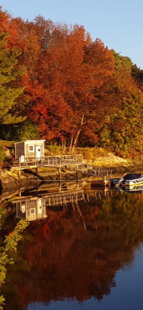
here’s my neighbors dock in the fall (note the hightide mark on the rock) and it is now,
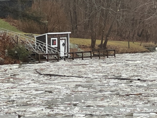
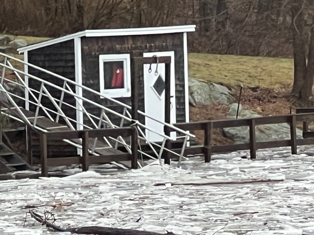
Read that PWM peaked 12:06 PM, at 14.57 ft, 0.40 above the previous record. Peak must be 1.5-2 hours later at Pit 2. (It's about 4 hr behind PWM at AUG.)
-
3.5" at 11:30, lots of teeny snow-things at noon.
-
1
-
-
35 minutes ago, Damage In Tolland said:
This is so much like that 2010 event
2" in 45 minutes at RUM, 1" at home, best snowsquall since we moved from Fort Kent in 1985. (Unfortunately, that event brought the last flakes of powder here for the 09-10 snow season.)
-
About 2" new, moderate snow falling almost vertically, upper 20s.
-
1 hour ago, moneypitmike said:
It’ll be interesting to see what it’s like at pit2.
I wonder how high the water got on Dec 19 or 20, as the Kennebec peaked art 167k cfs, about halfway between the record (232k cfs in 4/1987) and 3rd place.
Dews have dropped considerably today, now in the mid-teens. Might delay significant snow as the dry air gets overcome, but also might delay the changeover to RA. I'm guessing 4-5" here plus 1/4-1/2" wet.
-
1
-
-
1 hour ago, 40/70 Benchmark said:
I'd shovel it before it froze.
After clogging the snowblower before it went 5 feet in the slushiest part, I parked the machine and, fortunately, was able to have the driveway plowed. (1st driveway-plow since moving into our first house in 1977, in Fort Kent.) The ice was left after plowing the slush and that night's below freezing temp.

-
2
-
-
48 minutes ago, 40/70 Benchmark said:
I'll take several inches and rain over a few inches of sand.
You might change your mind if you had to negotiate our glare ice driveway. It needs some white "gravel", soon. 2-4" cornmeal, packed, would be very welcome.
-
13 hours ago, powderfreak said:
Japan is a bucket list snow spot on the north island. Cold air from Siberia, crossing the Sea of Japan, then plowing into high topography… it’s a dream set up. Theres a reason some of these towns average like 400-500”.
26” overnight in Niseko, Japan a couple days ago, with rates to 6”/hr. The culture plus snowfall and ski terrain… would love to visit someday.

The Japanese Alps along with the heights in Hokkaido must be in the running for snowiest places on Earth, along with Rainier, Baker and the mts behind Sitka and Juneau.
-
11 minutes ago, ORH_wxman said:
Yep. Don’t see any major red flags at the moment other than compression but the synoptics are working in our favor for once to overcome a negative variable. Hopefully we can bring this one home in the next few cycles.
My hope is for some snow that the grandkids in SNJ can play in. The only accumulating snow they've seen since 2021-22 led to needing a short tow in Jay as they headed back south following an 8-day visit here.
-
1 hour ago, mahk_webstah said:
And that’s at 7pm. If there is a snow pack in clear skies, that is a night that will be in the single digits.
Average temp here for Jan 24 is 25/3, so it might be AN (slightly) anyway.
-
50 minutes ago, STILL N OF PIKE said:
Extremely Similar in location, amounts will in my opinion be 2/3 as much snow due to less QPF .
WPC and HREF are much tamer than Wednesday.
WPC does not have 8”+ progs above 50% anywhereMy guess is 6-9” in Conway and maybe 10 @ Wildcat
Will be interested to see if Bretton woods avoids shadowing
GYX always has some weenie colors on those maps with a more subdued discussion totals , they had 18-24 swath for Wednesday and the only place I saw verify was someone measured within 1-2 miles of Mt Wash summit but they nailed their forecast totals that they had out in the warning areas
That's my thinking, especially after seeing WWA colors rather than the WSW for last Wed. My area was in the 8-12 color then (final pre-storm forecast 6-10) and the 4-6 color this morning. My 9" then was lower than places just to the west, where 10-14 was the rule. Coastal flooding is the main threat this time, as astronomical tides are a foot higher tomorrow than last Wed. Looking for 4-5", with the rain maybe half the 0.84" that made the Wed stuff all but immovable.
-
1
-
-
On 1/10/2024 at 10:53 AM, dryslot said:
Always take the under and you'll be more right then wrong.
That's my philosophy. Didn't work on 12/18 - last time I experienced 50+ gusts for 4 hours was on 12/31/62. (Doria and Bob had stronger gusts, but only for an hour or so.)
-
34 minutes ago, UnitedWx said:
Likewise. Although that's why a season like 95-96 was so great. Lots of pack for a very extended period throughout the winter, and many many events
Lots of snow in 95-96, its 138.8" was tops of my 13 winters in Gardiner by 30". That trails only 2007-08 since moving from Fort Kent in 1985. However, the major thaws, especially in January, tempered my enthusiasm.
Five top SDDs for Gardiner winters:
1993-94 1,993
1986-87 1,879
1989-90 1,641
1992-93 1,352
1995-96 1,290-
1
-
-
36 minutes ago, Volcanic Winter said:
Wow, genuinely don’t recall that one. Beautiful precipitation band though, VA to Maine simultaneously…
Looks really good for an event that only brought us 3.8".
-
1
-
-
Sun came out at 11:30, after 10 minutes of calm and fog. Headed out to the catch bucket and a couple shovels of glop.
Total precip: 2.18"

Monitoring some form of significant ( to be determined more precisely) impact winter storm, Jan 16/17th. Moderate seems to be the upper limit - for now
in New England
Posted
When I use the confused emoji, it means that I was confused. ymmv.
This storm grows up in N. Maine - CAR forecast is 8-14. Latest for home is 4-8, which has steadily edged upward over the past 2 days. We'll wait and see what the GYX night crew thinks.