

Jebman
-
Posts
7,827 -
Joined
-
Last visited
Content Type
Profiles
Blogs
Forums
American Weather
Media Demo
Store
Gallery
Posts posted by Jebman
-
-
Mammoth is open. It's a massive powder day. Palisades is opening up as well, and it is still snowing HARD there! It's a spectacular day in the white room and you better pack a snorkel if you go off piste! Deep stashes are plentiful and this is a great day to carve out some great turns as we have three feet of fresh pow at Mammoth and 6 feet of fresh pow at Tahoe, with even MORE snow pummeling the Palisades!
-
 2
2
-
-
Palisades Tahoe has 6 feet of snow. It is still snowing. They are planning to open Monday. Ski Patrol said they will be digging out for the foreseeable future.
Damn I envy them.
One pic of them showed a man trudging thru 3 feet of pow. He looked kind of punked out.
-
1
-
-
19 minutes ago, nj2va said:
That’s just too much snow, lol.
For you, lol.
But for ME, There can NEVER be too much snow. Day After Tomorrow was not enough snow for me. Winds weren't nearly high enough. Tahoe's 190 mph wind gust at the Crest met my needs well, as well as insane amounts of the snow. I absolutely worship how that snow blew off the roof at the Mammoth Main Lodge in 125 mph gusts!
Nothing on earth is more important, than getting to see THAT and blasting all my tracks at 950 decibels.
There is NEVER too much snow. There is never enough snow. And that WIND really needs to blow that pow all over the place, in huge white clouds that blot landmarks out for weeks, severely disorientating travelers who soon end up just like Luke Skywalker on Hoth. I wub that blowing powder so much! Mammoth showed me all about that! I love Mammoth, I love Tahoe, and I love Donner.
I can still get my fix from blowing snow off the Woolly Lot.
https://www.mammothmountain.com/on-the-mountain/mammoth-webcam/woolly-cam
-
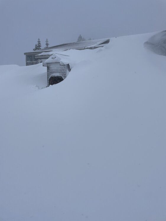
3 hours ago, katabatic said:
Greetings again from Donner! This epic storm continues. The entire front of the condo building has now disappeared. We’ve been taking turns at an entrance on the windward side, keeping that open (well, kinda) so at least we can get outside. To get this picture, I waded through waist to chest high snow. I have done multiple lake effect chases so I have seen some pretty intense snow but earlier today we had a thunderstorm that easily dropped 4 or 5 inches in 30 minutes. Still no power, no plow and no internet (phone works!) but warm and well fed. What a once in a lifetime experience for someone who loves this stuff.
I am absolutely full of jealousy! Wow man the snow at night in the lights must be awesome!
You came in search of a snow fix. I think you found some!
WOW 9-10 feet of snow!!! And even MORE on the way! Find a job, stay there! You have found HEAVEN!
The Sierra has got everyone else OUTCLASSED! They dont get that much in the Northeast. All the Great Lakes got was only 6 feet.
I pick the Sierra! I WORSHIP Tahoe and Mammoth with all my snow weenie heart!
Mammoth is still blowin hard, ground blizzard. Tahoe is still getting heavy snow and blowing all over, still piling up snow! As can be seen above, Donner is still snowing and blowing and it looks like they have gotten at least 9 feet, maybe 10 feet of snow with another couple feet to come then yet another storm in a few days will dump yet another 2 feet!
Obviously, the Sierra is the place to BE if you love snow. The Cascades are another good place. Extreme high winds plus insane amounts of snow are the BEST. Donner, Tahoe, Mammoth win hands down!
-
1
-
 1
1
-
-
Mammoth still has blowing snow and some light to moderate falling snow. But Tahoe is still getting heavy snow. It looks like they got at least 5 feet of snow. Mammoth got about three and a half feet.
-
Both Palisades and Mammoth remain closed. Winds are still too excessive to open lifts. Snow continues to pile up as well. Visibilities are better. People are out walking around. Mammoth has 3 feet. Tahoe has a TON of snow, probably 5-6 feet. I heard Donner Pass may have ~8 to 9 feet.
There are a lot of folks stuck on the highways. Some of these ppl have been in their cars for 2 days. This is a full blown desperate emergency. It's still blizzarding.
Katabatic is marooned at Donner in an airbnb expecting at least another 4 feet of snow. Yesterday he reported 7 feet so far. He was lookin for a snow fix. He got some, alright lol. The snowblower the condo association uses to clear all the snow is broken. In the meantime, snow piles up there and the wind is stacking drifts. Hope Katabatic is okay. He is out of power and has no Internet, though his phone works.
-
15 hours ago, katabatic said:
This sure has been one hell of an adventure. I don’t have power, I don’t have Internet although my phone still works thankfully. The snowblower that the condo uses to dig us out is broken and they don’t think we’re gonna get any back up until at least Monday. I estimate we’ve had about 7 feet with another 4 to 6 to come. If I don’t get out on Monday which is when my flight is, Tuesday and Wednesday we’re going to get another 2 feet.
You came for a snow fix. It looks like you found one. Wow all that snow! You sure know how to pick when to vacation in a snow zone! I envy you and am jealous as heck! Enjoy the snow! Dig massive amounts of snow! Dig a snow cave! Have fun in it!
You wanted snow. YOU GOT IT!
You are getting a genuine Donner Experience!
-
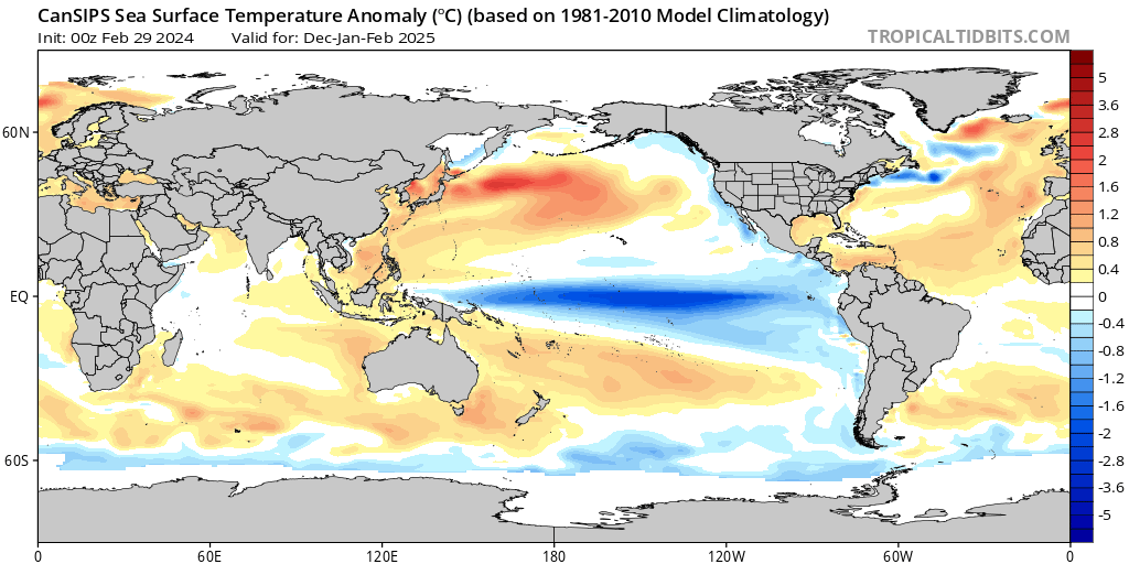
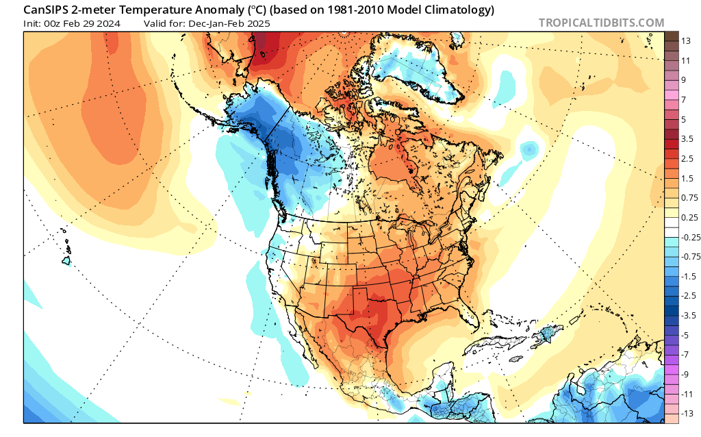
13 hours ago, Terpeast said:
A look ahead to the 2024-25 winter... not for our own backyards, but WHERE to travel and chase (and when):
New CanSIPs just came out, and it performed well on a smoothed/seasonal basis for this winter. It showed a wet first half, then a slightly drier second half, and a mostly warm CONUS with near normal/slightly BN southeast.
So here's what it is showing for next winter now...
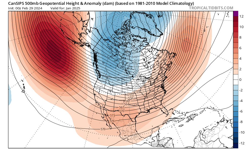
1) Moderate-strong La Nina, basinwide or even a little bit modoki. MJO should be active in the eastern IO through the MC (phases 3, 4, and 5). Negative PDO signature appears obvious, with that marine heatwave off Japan still ongoing and no signs of ceasing.

2) Standard La Nina h5 configuration enhanced by overall warming with a solid +AO/+NAO (or lack of blocking overall). Take away that -NAO block in December 2022 in the 2022-23 winter, then you'll get a good idea of what this winter is going to be like.
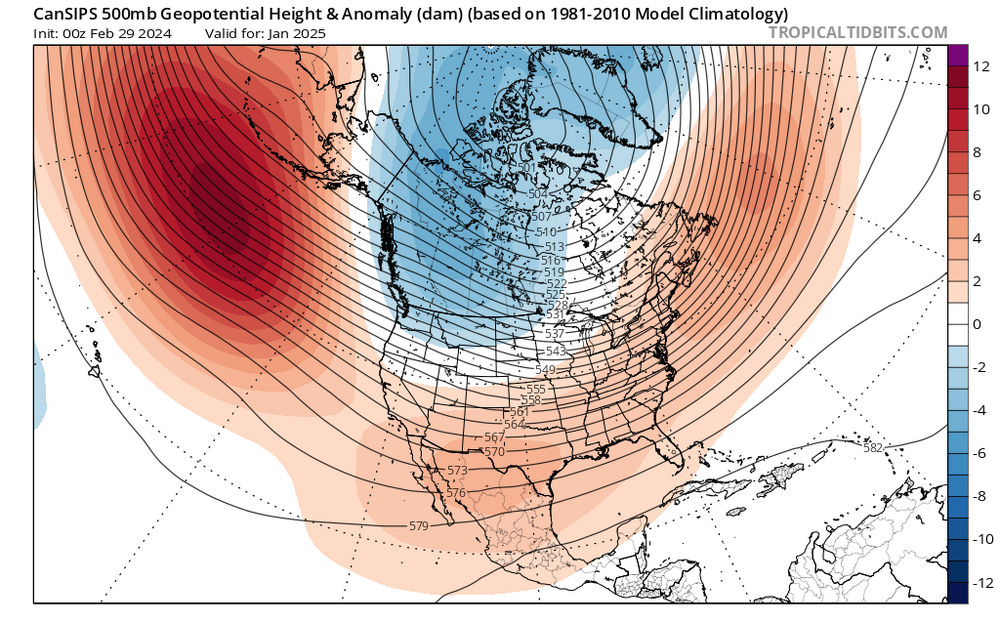
3) Again, a mostly warm CONUS just like this year, except the warmest anomalies are displaced south across New Mexico, Texas, and through the Tennessee Valley. (I wonder what raindancewx has to say about his backyard having the warmest anomalies).
However, the west coast and Pacific Northwest are depicted to have near to slightly below normal temperatures.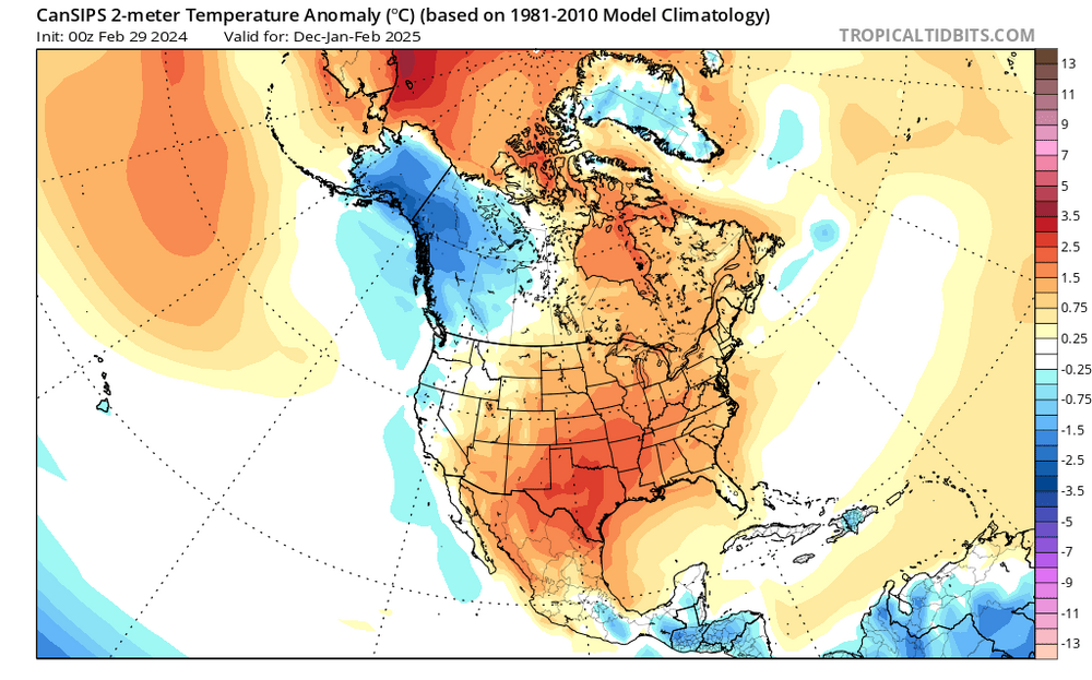
4) Opposite to this winter, the south and southeast are depicted to be drier than normal. It would not surprise me if we got a hot and dry summer, with drought conditions redeveloping across the east.
Wettest anomalies are shown over the Pacific Northwest, and with normal to slightly below normal temps, the mountains in that area could be the best places to chase.My brother lives in Spokane, and they may be set for a great/historic winter next year. Seriously considering an extended two-week visit there, renting a car, staying with him for 4-5 days, then drive to Montana's rockies for a few days, then back. Or if the Cascades are about to get a big one, we could chase there instead.
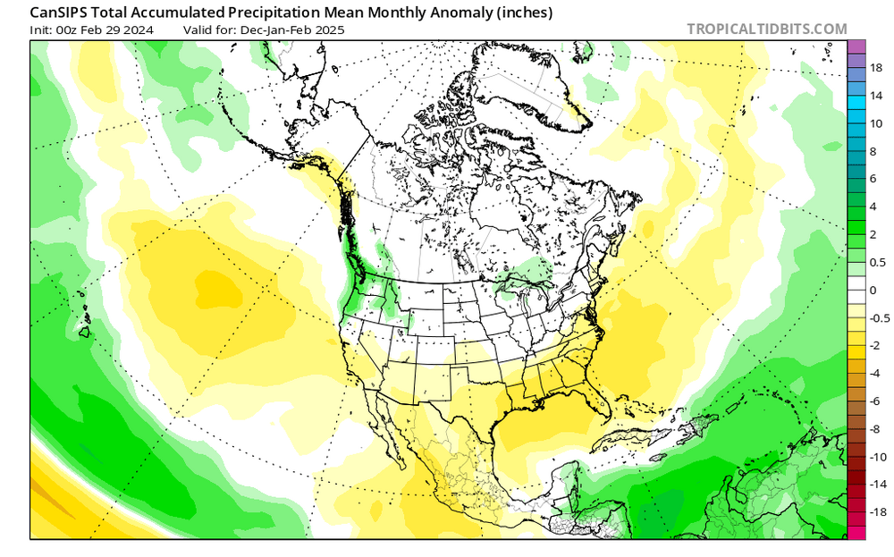
Again, this is to show you where to plan your chases for next winter, not for snow in your backyards.
Excellent point.
Weather is changing. We need to start thinking in terms of mobile backyards. Figure which mountain regions will get obliterated by snow then go there and get your massive snow fix.
I live in south TX. My mobile backyard is located in Tahoe or in Mammoth, particularly that Woolly complex. That place gets destroyed a lot by both damaging winds and torrential snows.
Heavy snow is great for a fix. But there is nothing like a decent dose of severe Category 5 winds to get things nice and spicy!
-
On 3/1/2024 at 9:23 PM, Maestrobjwa said:
So am I. I laid out in the snow for a good 10 mins just appreciating having even that much snow to lie in (in fact, I wish I'd stayed out there longer!). It may be little while before we that again.
And overall...we need to be thankful for what most of us (except for maybe a couple posters) experienced between 2009-2016. Epic stuff!
Next time you lay in the snow to appreciate it I will drop by and shovel fresh pow from Mammoth over you to make it a singularly memorable experience lol.
This is what in the snow resort space we refer to as a genuine 'Jebman Special'.
-
In the Village in Mammoth, it is snowing SO HARD it's unbelievable! They must already have a new foot of pow! They JUST plowed that!
In life, there is no better thing, than to be Mammoth'ed by high winds and insane snow rates! I absolutely LOVE Mammoth to the utter exclusion of everything and everyone else!!!!!!!!!!!!!!!!!
We are getting gray outs again in the world-famous Woolly lot as the winds come up and a burst of torrential snow smashes into the Sierra tonight!!!!
The Village at Mammoth is getting absolutely obliterated right now! It's WORSE, than last night!!!!!
Woolly is getting so obliterated that they have a near constant gray-out! It's very high winds plus an extra burst of very very heavy snow that is utterly assaulting the living hell out of the Woolly region!
-
Might want to check out the Palisades cams, 8200 foot Scope shows a decent drift. This is the first time in DAYS I've been able to see anything Tahoe.
https://www.palisadestahoe.com/mountain-information/webcams#tab=palisades
Alpine cams are still worthless. Its pretty windy up there. They've been closed down all day anyway.
Mammoth cams are usable and it is still snowin and blowin there, tho a tad less than last night's wonderful grayouts with tons of snow comin down!
The forecasters were spot on with the water equivalents and they got the snow, BUT the high winds broke the aggregates up in smaller flakes that did not pile up as high and the winds blew some snow off the measuring sites. That's why Tahoe probably has 4 feet now and Mammoth has 2-3 feet now. Up to three more feet could pile up by Monday morning, but the caveat is that the winds will break up the flakes and reduce snow depth measurements. But I KNOW what I saw come down last night! It was white GOLD and those 100 plus winds made for an exciting, rousing show! To my everlasting joy, Tahoe recorded 190 mph winds at crest last night! THIS IS MY KIND OF WEATHER! IT'S MY KIND OF WEATHER!
This is still an INCREDIBLE storm and I am very happy I got to witness last night's extravaganza!
Wow I am so happy and full of vicarious snow, I close my eyes and all I see are whiteouts and tractor blades tryin so hard to clear deepening snowpacks on the lots of the resort!
I LOVE MAMMOTH SO MUCH! Just have a look at all that blowing snow!
https://www.mammothmountain.com/on-the-mountain/mammoth-webcam/woolly-cam
CHECK IT OUT! LIGHTS ARE BACK ON AT THE MAIN LODGE!
https://www.mammothmountain.com/on-the-mountain/mammoth-webcam/main-lodge
-
Today, snow is falling, strong winds are still blasting snow. Both Tahoe and Mammoth are closed because of high snow rates, high winds and visibilities shot completely to hell. I have never seen The Village in Mammoth like this. This is a serious storm. Plows are very very busy today. People are walking around bewildered by the horrific conditions. Mammoth got 20 inches overnight. How can you tell with strong winds blowing the powder all over the place at 15 degrees? Not sure how much Palisades has gotten so far. Woolly cam portrays a very dark snowscape with very bad visibility. Snow is blowing all over. I have gotten one heck of a high octane snow fix off of the Mammoth cameras, especially last night!!! Very high wind gusts are causing gray out / white out on the woolly lot. The storm is still raging nearly at last night's ferocity.
Wow wow wow wow wow Mammoth is such a snow enthusiasts paradise! Those winds are really blowing that POW all over! They plowed that lot BUT the storm just piles more pow on! This place is whiteout central! Mammoth NEVER, EVER lets you down!
Are you kidding me???????? There's a Bus and that whiteout was so damn BAD, you can't even see the bus! The bus was only a few scant feet from the camera! Man I am falling head over heels in sweet WUB with Mammoth!!!! What a storm! What an incredible blizzard this is!
This is SO bad, you could get so overly cold jebwalking out in this then get so badly disorientated in the ongoing whiteout, that you could easily end up like Luke Skywalker on Hoth.
Ha ha guys getting pics in front of the Mammoth in the teeth of the blizzard lol. Another bus full of touristas lookin at the shut down lifts amid huge blowing aggregates! Mammoth fell to 14 degrees. Still snowing and blowin real hard, whiteouting to death. Touristas can't resist, they are jebwalking all over lol.
-
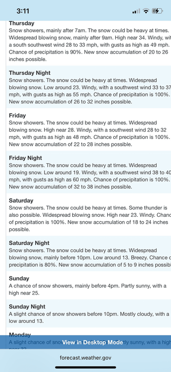
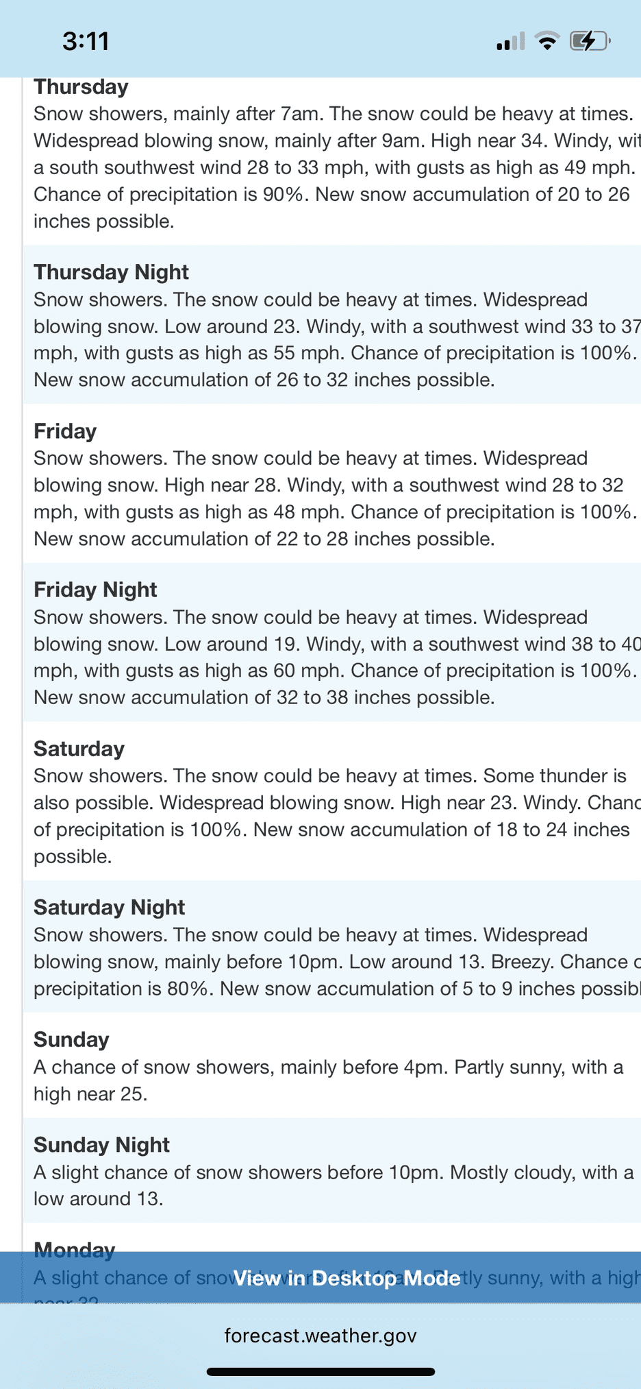
On 2/29/2024 at 9:51 PM, George BM said:
Forecast Discussion
Saturday, March 16, 2024 3:28PM EDT
Blizzard Warning in effect from 8AM EDT Sunday, March 17, 2024 until 3PM EDT Monday, March 18, 2024
High Wind Warning in effect from 9AM EDT Sunday, March 17, 2024 until 6PM EDT Monday, March 18, 2024
Hurricane-Force Wind Warning in effect from 2PM EDT Sunday, March 17, 2024 until 6AM EDT Monday, March 18, 2024 (for tidal-Potomac and Chesapeake Bay)
Life-Threatening Late-Winter Storm to cripple the region.
Temps are currently holding in the mid-50sF across the DC metro area but are already starting to fall in far northern Maryland as the cold front associated with the strong northern stream system drops south through the region. Temps will plummet out of the 50s and through the 40s and 30s through the evening and reach the lower 20s in many areas by morning as the unusually cold airmass pushes in. As this occurs through the late afternoon and evening hours skies will become overcast both from lift associated with the southward moving cold front and from the strong southern stream system to our south/southwest. There may be enough lift and moisture associated with the front for some light sprinkles and/or a few flurries/light snow showers to develop through the evening before precip slips to the southeast. Northerly winds will become quite gusty during this time with gusts of 25 to 40 mph.
As the strong southern storm system moves toward the coastal Carolinas tonight it will begin to phase with a second powerful northern stream vort diving south from the eastern Great Lakes/ Toronto region leading to strong diffluence over the surface low leading to rapid deepening. The two will pinwheel around each other as they phase bringing the southern storm and associated surface low northwards as rapid deepening takes place allowing snow to overspread the region by morning from southeast to northwest. The snow will quickly become heavy as NE winds increase with gusts to over 50 mph across the region likely by midday. Temperatures during this time will be in the lower 20sF leading to windchills in the single digits. By the late afternoon/evening the surface low will slow down and eventually stall over the Virginia peninsula/ southern Chesapeake Bay area. The surface pressure could be as low as the mid-950s in millibars breaking monthly low-pressure records in that area. Meanwhile, the areas northwest of the surface low (the greater Washington DC and Baltimore metros) will be getting the worst of this storm with blinding snowfall and widespread 60-75+ mph wind gusts w/ 80-90+ mph gusts along the coast of the Bay. In fact, snowfall rates in the heaviest bands will likely be in the 4-6”+/hr range leading to visibilities as low as 50 feet (effectively zero visibility for the sake of argument) from the late afternoon hours through the night and into Monday morning. Temperatures will remain in the 20s throughout the duration of this event with upper teens possible in the higher elevations north and west and temperatures closer to 32F in far southern MD and along the bay where warmer air will be located near the surface low. Windchills during the duration of the event will stay in the single-digits for most w/ negative single-digits in the mountains and lower teens in southern MD and along the bay.
Near-whiteout and conditions and severe wind gusts will still be ongoing by dawn Monday as the low-pressure system slowly pulls northeastwards. Heavy snow will continue through the late morning to midday hours before tapering off from west to east. When all is set and done with total liquid-equivalent precipitation of 4-7”+ across the region, snowfall totals of 4 to 6 FEET will likely be commonplace with snow drifts of as high as 30 feet possible. Areas in southern MD and near the Bay may end up with slightly less (roughly 2 to 4 feet) as the warmer air associated with the low-pressure center cuts down on totals in that area.
This will be the worst blizzard, by far, to impact the region since weather records started in the later 1800s. It will essentially be a high-impact hurricane with snow instead of rain as the main precip-type. People who venture outside during this time may get disoriented and lost in the whiteout conditions and/or get seriously injured by flying debris. Emergency services may not be able to reach you for days should something happen to you outside. This is the DC and Baltimore urban corridor not Lake Tahoe or the Japanese Alps. We’re not equipped with the snow removal equipment that they have. So, if you absolutely must venture outside during the storm no caution that you use would be too extreme given the circumstances.
Temperatures will only rebound to the lower 30s as skies start clearing by mid to late afternoon on Monday.
Forecaster Wannabe: George BM
You are NO wannabe.
Best I have ever read from you, George BM! That storm could have been pulled straight out of the Sierra Blizzard! Wow!
75 mph winds with snow, 30 foot drifts! Wow wow wow wow wow!
If something like this happened in the DC Region I'd BE THERE to dig everyone out with my SHOVEL, not a dumb snowblower!
-
1
-
-
Its unbelievable what this storm is forecasted to dump on Tahoe and Mammoth. By the end of the new week, Tahoe could have an ADDITIONAL 10-11 FEET, this is on top of what has ALREADY FALLEN lmao!
Tahoe may have about 15-25 inches already. They have been under massive assault by this storm since early Thursday, thru Thursday night thru Friday into tonight/this morning. MUCH MUCH more yet to come.
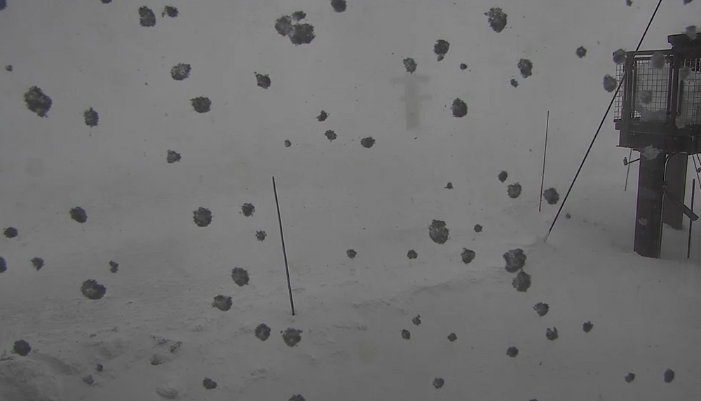
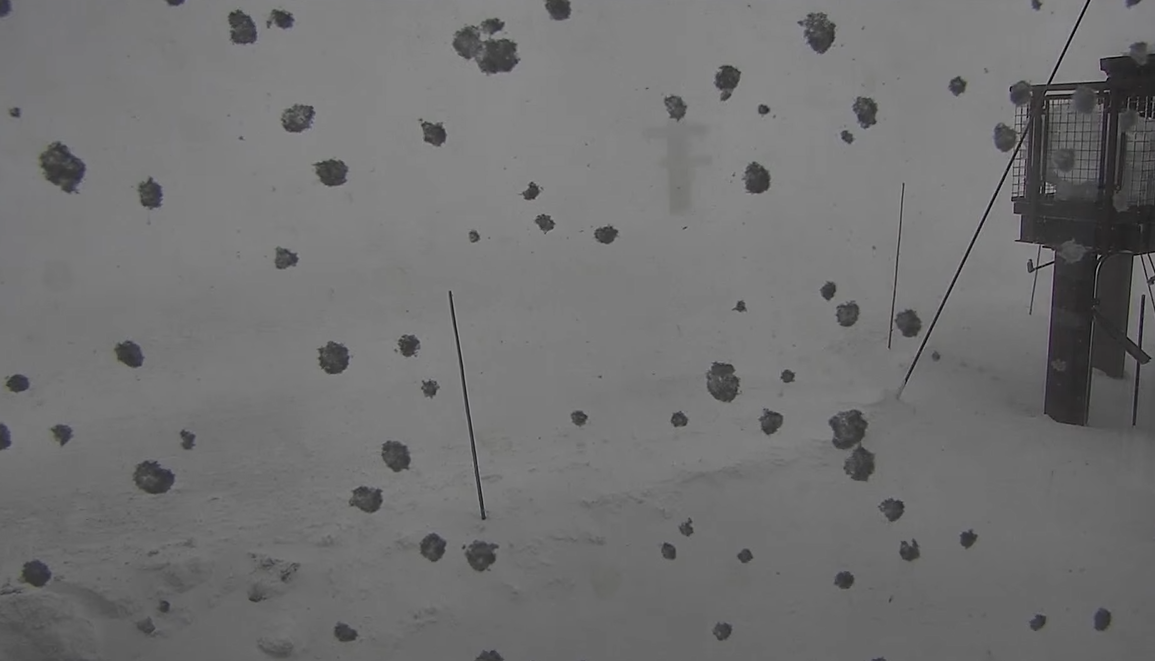
Winds are gusting into the 100-110 range, creating gray out/white out conditions. This can be seen on the Woolly Cam at Mammoth, even at this time with many of the resort outdoor lights switched off.
https://www.mammothmountain.com/on-the-mountain/mammoth-webcam/woolly-cam
MUCH more heavy snow and high wind to come today Saturday, Saturday night and Sunday. More snow Monday as well.
Tahoe or Mammoth or Truckee are great places to get a snow fix in.
Tractor blade guy is at it again, this time he has more snow to plow. He's got his work cut out for him tryin to keep the resort plowed. This storm is relentless. I hope people are not out trying to drive in this.
That woolly cam, it is a near constant GRAY OUT from very high winds just blasting unbelievable amounts of heavy snow! Thats NOT fog. Its very heavy snow being blasted to heck by insane wind velocities! Some of those gusts are well in excess of 120 mph!
This is NO TIME to jebwalk!
What you are seeing on the Woolly cam is tractor blade is pushing snow then a snowblower truck is blowing the piled up snow into a holding container in the back of the truck. They are moving the snow. It's coming down so fast they are removing it at intervals. They are gonna be busy all weekend.
Katabatic is in Donner Pass. He is getting a SERIOUS SNOW FIX right now I'll bet!
-
That woolly cam is compulsive watching! Those high winds are really blowing that heavy snow all over at Mammoth. I wub how the 100 mph winds gray everything out! Mammoth is my favoritest place ever! This place NEVER EVER lets you down! The drifting is so unbelievably bad, it is covering up the lights in front of the Mammoth!
Woooooooooooo----- Hoooooooooooooo!!!!!!!!
I really wub 100 mph heavy snow blizzards so much!!!!!!!!!
Mammoth is pure heaven right now! 22 degrees, lots of fresh heavy snow, visibilities have done gone straight out the proverbial window, and those refreshing winds are 60 to 70 mph with exhilarating gusts to 110!!!!!!!!! This is a steady state condition at Mammoth! Fresh snow is drifting all over the woolly lot the tractor blade guy just plowed! Ain't this cool?????????!!!!!!!!!!!!
Wow another huge 110 mph gust! INSTANT GRAY OUT! CANT EVEN SEE A SINGLE THING UP IN HERE! I wub 110 mph blizzards loaded up for Bear with torrential snow SO MUCH!!!!!!!!!!!!! I am watching this and BLASTING Elton John tracks!
One report from Tahoe, winds clocked at 167mph. Damn this is serious serious bisnass!
-
Mammoth is turning into a milkshake froth at times. You can barely see the Mammoth from the woolly cam lmao! Winds are really picking up amid moderate snow. That WIND is blowing all that fresh snow all over! This is becoming intriguing lol.
As of 848pm central time, apparently moderate to heavy snow is assaulting both Tahoe and Mammoth. Tahoe has been under assault since yesterday. Tahoe probably has at least 12 to 18 inches. Mammoth is unbelievable, heavy snow whipped around by winds that tonight are forecast to reach 115mph. That's Category 3 hurricane force gusts! They are calling for up to 39 inches just tonight/overnight. Not sure how much has fallen at Mammoth. The problem is very high winds, it is going to be very difficult to verify just how much snow has fallen. I think based on eyeballing the woolly lot and the Village lot, about 8 inches of snow have fallen at Mammoth but the reality is probably more than that. Drifting is getting ridiculous, I have been scopelocked on Mammoth since November, some of these shacks are developing 6 foot drifts, could be taller. These winds are life threatening. I can see why Ski Patrol has shut things down at Mammoth and gotten folks in buildings. The drift by the mammoth on woolly lot looks to be about five feet but is likely taller. With the milkshake froth developing from heavy pac moisture snow and extreme wind gusts, it will be easy to become disorientated and lost then succumb to the cold and blowing snows. Two meter temperatures will fall to 12 tonight in and around Mammoth. Wind chills are going to be Everest-like. This is definitely NO time for a jebwalk. Snow is expected to become not only very heavy but also of a drier character and will blow around in the admittedly insane wind gusts. Visibility will be shot completely to hell and back. Apparently storms delayed in the Sierra are not necessarily denied. This storm was a day and a half late, but it is still going to destroy Tahoe and Mammoth and many other Sierran communities. Not sure how much snow will accumulate - that is for local folks who truly understand how this stuff goes in that part of the world. As for me - if I was there I'd be a frackin statistic in no time. I would try to jebwalk then get slammed by a freak 125 mph gust and smashed against a mountainside. As for my forecast last night, I was balls wrong lmao. Some March 2001 redux lol. It took its sweet time getting to Mammoth but its here now and will blast severe winds and snow against these communities with no mercy at all. I dont know how much snow they will ultimately get. Its going to be a lot, though. I am admittedly getting my snow fix, and then some!
You might want to peruse these links.
https://www.mammothmountain.com/on-the-mountain/mammoth-webcam/woolly-cam
Main Lodge will have lights until 3am your time! You might want to take a gander at those! Its unbelievable! Heavy snow plus crazy high winds!!
https://www.mammothmountain.com/on-the-mountain/mammoth-webcam/main-lodge
When those winds come up, they turn the heavy snow into a kind of milkshake-like froth! This place is a snow lovers paradise but it could also be frankly dangerous.
At times, that insane wind whips the snow into a kind of solid gray WALL - You can't even see a damn thing! That place is Heaven! Wow wow wow wow wow wow wow wow!!!!!!!!!!!!!!!!!!!!!!!!!!!!!!!!!!!!!!!!!!!!!!!!!!!!!!!!!!!!!!!!!!!!!!!!!!!!!!!!!!!!!!!!!
Given these unusual storm conditions, woolly cam lot will be quite the picturesque draw - even after the resort switches off the Main Lodge lights. You'll still be able to see LOTS on the woolly cam lot!
Guy with a tractor blade plowed the woolly lot but the heavy snow keeps right piling up and drifting in hurricane force gusts lol.
-
6 hours ago, GramaxRefugee said:
They seem to have measured gusts at 145mph..
https://forecast.weather.gov/product.php?site=rev&issuedby=REV&product=PNS
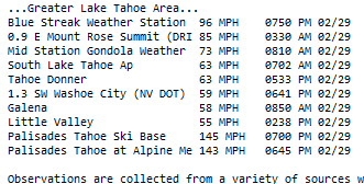
Notice how their gadget drops the highest to the bottom because its not set for 3 digit measurements.
The winds have been very bad. NWS got that right. Palisades is shut down because of winds. I doubt Tahoe got much more total snow than 10 to 15 inches. Mammoth got one inch overnight. Mammoth is running their lifts, probably because the winds there may not be as severe. The snowfall sure is no problem lmfao. Six to ten feet my @ss. This storm has got damaging winds but it is turning out to be a hell of a lot drier than what that gfs was printing out. Palisades will get 2 to 3 feet by Tuesday. Mammoth might eke out 8 inches by the end of next week.
I am just sick with disappointment. I craved a total snow disaster replete with cottonwood canyon style avalanches and huge drifts and people stuck on roads in ten feet of snow. But alas Lucy pulled the football and left me on my ass crying with disappointment. Base state for the Loss.
Wow 145 mph gusts. Category 5 hurricane force winds! No wonder Tahoe shut down the entire resort. You would have to have a death wish to be out roaming around in that maelstrom. Not sure even a snowcat would be a good idea.
I think there are now about 4 inches of snow on the wooly lot at Mammoth. Snow there is steady.
As of 230pm central time, woolly lot camera is showing considerable snow rates with a few rather large aggregates. Snow on the lot looks to possibly be ~ 6 inches deep.
-
Not really sure why visibilities are getting so low on woolly camera at Mammoth. Winds are increasing a lot. That wind is beginning to take on a kind of milkshake froth appearance. Not really understanding what I am seeing here. Okay there is some increase in areal coverage of snow on the woolly lot. It is blowing around a lot more than it did at 3am my time. Winds are gusting to damaging speeds. If snow is actually accumulating, it will be extremely difficult to measure because of 90 mph gusts.
I am not hugging the gfs. This snow is probably only a brief shower or two. This storm is a day late and one hell of a dollar short! We shall see but I am not fooled by the goofus's siren song of 10 to 12 feet. That is pure nonsense. Maybe a foot for Mammoth over the next 10 days including the next storm later next week. I threw that useless gfs out! It's an outlier.
-
Tahoe is getting some steady snow. Mammoth is getting a few flurries. NWS will end up trimming the amounts down some. It is doing some snowing but overall this storm is much much much drier than models have been predicting. That Goofus model is extremely high on snow crack. This storm does not have eleven inches of water. Maybe three or four. NWS has been hugging the GFS like a damned overexcited snow weenie. No, NWS has been outright making passionate love to the GFS! Tahoe might get 6 inches overnight. Mammoth will have a few passing flurries. Damaging hurricane wind gusts are the big story with this storm. Snow amounts, naso much. Actually, hardly any snow at all. Tahoe might eke out 24 inches by next Thursday. Mammoth might get a few inches, barely plowable. I wanted that heavy snow so bad, especially in Mammoth. But the base state won again. Even the Sierra have to abide by it. This Pacific storm is drier than a Texan martini in a successful Bar Rescue nightclub. Damn the base state, and damn Lucy to hell.
Poor Mammoth. No snow at all. All that hyping by the media and NWS came to nothing. I would not be surprised if it was sunny and 49 degrees and a spectacular bluebird day tomorrow in Mammoth. I feel sorry for katabatic. He is in Donner Pass amid clouds and crazy high damaging winds and in all likelihood, occasional flurries and not much else. If you listened to the crazy weather reports 72 hours ago and stocked up, you must feel foolish as fook now! This so called total FARCE of a storm has spectacularly fizzled right out.
This is now a laughable case of March 2001 for the California Ski Resorts. Meteorologists can write up some papers on the mysterious dried up Pacific West Coast Blizzard of Feb 29-Mar 5 2024, once they get done wiping EGG off of their faces.
NWS. You forecast 36 inches in Tahoe for Feb 29. You stated it would start at 10am local time. It did not start until late afternoon! They were fortunate to get maybe 5 inches! Can I have some of that prime hashish you are smoking? RENO NWS is insisting amounts have increased. They insist 10 feet by Sunday Mammoth Mountain. NWS, get off of the damn goofus model! Throw it out! All we have are flurries at Mammoth! The winds are very strong, you got that very correct. Back slowly away from the GFS! It is flat out WRONG!
-
This storm may be a fail. Snow is light and sporadic. I think the base state DOES apply to the Sierra after all. The initial push of moisture proved to be very light. NWS will probably need to trend forecasts down by a couple of feet. However, 4 to 6 feet of new snow is still a serious, if not outright biblical magnitude blizzard for the Sierra. Mammoth may end up skating with a lot less snow. It's blowing hard but has been very light all day. I would say 3 feet for Mammoth and 3 to 5 feet for Tahoe. This thing is wimping out at the last minute.
Damn. I craved a monumental biblical snowstorm. These things are getting rarer and rarer. Ha ha that ten feet for Mammoth is in trouble lol, they got one inch today uh oh.
2 hours later....... Very light snow at both Palisades and Mammoth. Very breezy. So far this storm has far more bark than bite lol. NWS, your apocalyptic forecasts for the Sierra ski resorts are ALL in dire peril. NWS, quit smokin all that GFS hashish! Would you believe this shoosh? They sent the HURRICANE HUNTERS into the pacific storm! LMFAO x 999 decillion! This storm does not have 11 inches of water. It will NOT dump twelve feet of snow. It is more likely to snow 5 feet in Tahoe and 2-3 feet in Mammoth. Cameras at both resorts show very light snow being blasted by very strong winds. NWS needs to quit the beer bong, right now. The GFS is WRONG. The storm is trending DRIER, not wetter and not colder. The trend, is NOT your friend, Sierra! You might end up dry as a Texan martini on Bar Rescue! LUCY has her eyes on your storm, Sierra lmfao!
Damn. I am bitterly disappointed. The snow is so damned LIGHT. I am ready to jump right off the Ledge. Reaper, please reap me again in some offhand way. I am officially giving up on the Sierra Winter. The Base State has won, and WON BIG. I WAS BALLS WRONG. THE SIERRA DOES, AND WILL, LET YOU DOWN.
I had my heart all set on watching torrential snows blow across the parking lot on the Woolly Cam at Mammoth. I craved to watch the PLOW bounce right off too much snow on the Woolly Lot. Lucy is a very mean lady. She pulled that blizzard right out from under us! Lucy pulled the rug so hard I smashed my head real hard on a snowless granite ground and got a life-threatening concussion! I am so damn depressed and inconsolable!
Mammoth has near zero visibility in blowing CLOUDS of water vapor and extremely light pixie snow! NOTHING on the lot! Wow what a monumental BUST, for all-time! To give you an idea of why I am so disappointed: They were calling for 36 inches TODAY! What a fooking BUST! They were lucky to get an INCH! An INCH all day! That's like the Allegheny Front this winter!
Tahoe has light snow. Mammoth has about 24 flurries. Aggregates are having a TOUGH time forming in that FAIL of a so-called "blizzard". Main Lodge camera shows extremely thick FOG, with NO additional snow accums on the black roof on on the deck. This smells like a BIG FAIL. It's EPIC tonight! You'd have a better chance of seeing snow in Falls Church Virginia, than in this rug pull of a storm.
Wow Main Lodge has a few flurries! Wow, better rename this place Washington, DC! lmao. Okay, to be fair, Palisades Base at 6200 feet has moderate snow. Maybe they can salvage this massive debacle. They already LOST three feet of snow they never got today. Maybe they will get 48 inches by next Wednesday. Maybe.
-
 1
1
-
-
5 minutes ago, nw baltimore wx said:
Any original Star Trek tv show fans here? Looks like the Tribbles have invaded the summit of Mammoth.
I watch EVERYTHING star trek! The Next Generation, Voyager, Deep Space 9, all of them!
-
Its ON! Tahoe is snowing an blowin! It's a mayjah wintah stahm, with a lot of blowing snow! Slow moving, loaded for fucking BEAR with several decillion metric tons of Pacific moisture! Many places will receive in excess of ten feet of fresh snow! Katabatic is up at Donner right now in an airbnb! He could see 10 feet!
-
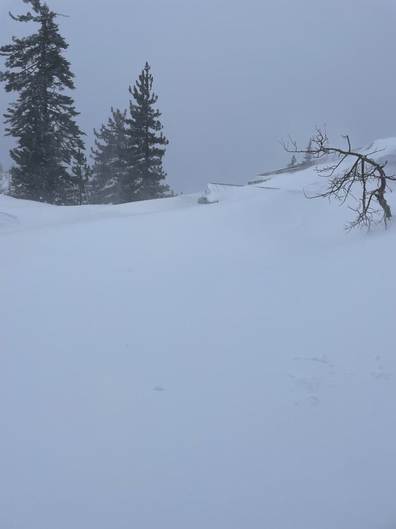
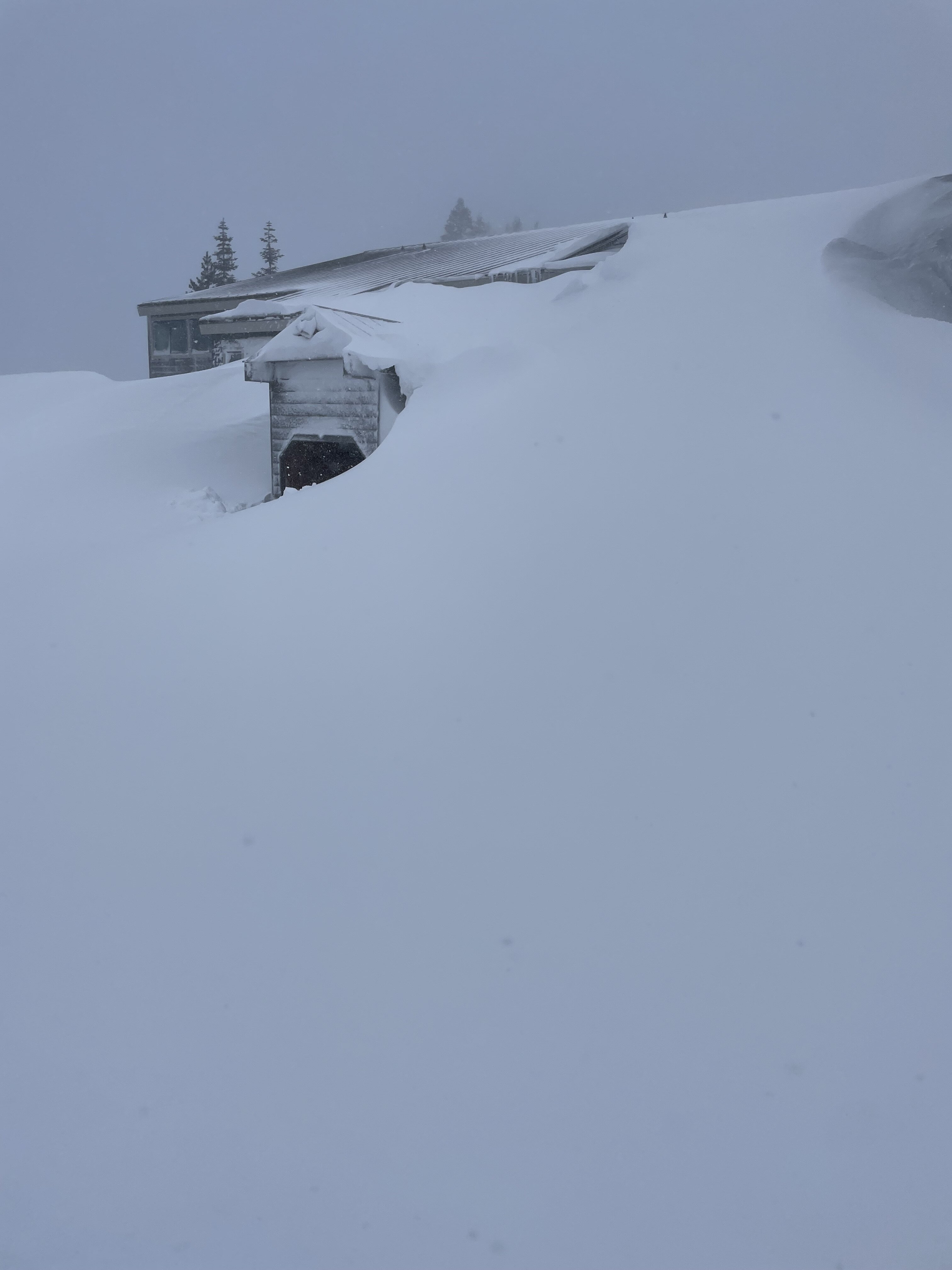
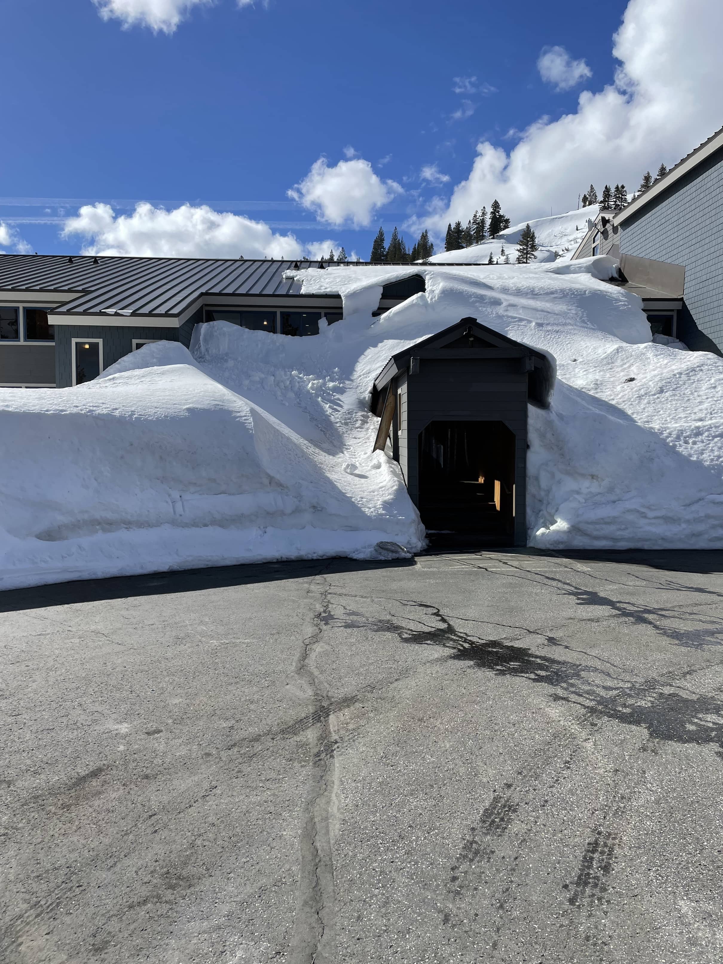
3 hours ago, katabatic said:
Your yin to my yang. Calm before the storm here. Finally made it to Donner Summit last night - and now looking at a forecast for the ages. The pic is the entrance to my Airbnb condo. Will be interesting to see what it looks like post storm.
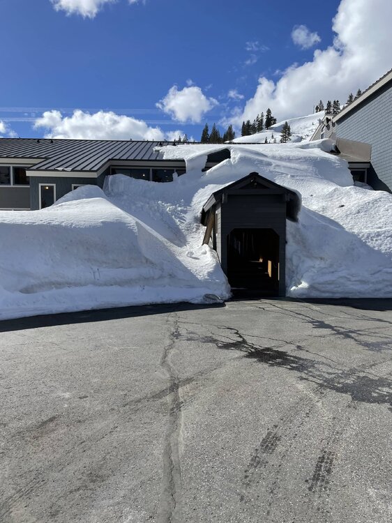
You are at Donner? Wow man enjoy the snow! Enjoy that 8 to 10 feet, take long leisurely jebwalks and dig massive amounts of snow!
I will tell ya what that place will look like post storm.
You will be forced to dig like a BADGER just to get out of that building. You are about to be DEMOLISHED by snow SO BAD! Hope you are stocked up! Don't end up like the Andes survivors in 1972 lmfao!
-
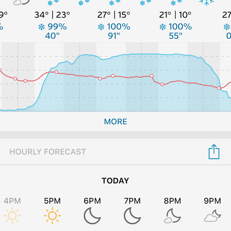
56 minutes ago, midatlanticweather said:
Just looking at the forecasts for some of the areas near Mammoth! INSANE!
Here is the output from one of the plowing companies. LOL!
ARE YOU KIDDING ME?????????? 91 inches of snow in a single frackin' DAY!
I am jealous as all hell!


March Discobs 2024
in Mid Atlantic
Posted
Correction.
Palisades did not end up with 6 feet. Last night they piled on an extra 12 inches. They got SEVEN feet from this mega blizzard!!
EDIT:
https://blog.palisadestahoe.com/weather/digging-out-from-8-feet-of-snow/
I was balls wrong about Palisades earlier today. They got eight feet total, IN FOUR DAYS!
They have got a ton of digging out to do.