Snowncanes
-
Posts
169 -
Joined
-
Last visited
Content Type
Profiles
Blogs
Forums
American Weather
Media Demo
Store
Gallery
Everything posted by Snowncanes
-
The “I bring the mojo” Jan 30-Feb 1 potential winter storm
Snowncanes replied to lilj4425's topic in Southeastern States
ULL is a bit more north and transfers earlier. I still think y’all will be fine in the upstate in the 3-6 range -
The “I bring the mojo” Jan 30-Feb 1 potential winter storm
Snowncanes replied to lilj4425's topic in Southeastern States
absolutely insane rates in E NC on the 3k nam. LP just sitting there absolutely cranking for 20+ hours straight. Looks like models are catching on to it being more west, somewhat in line with the Gulf Stream. Dream E NC setup -
The “I bring the mojo” Jan 30-Feb 1 potential winter storm
Snowncanes replied to lilj4425's topic in Southeastern States
Last model that ran was an hour ago and everyone is resting up for all the show were going to have to shovel. Remember we don’t have plows in the south haha -
The “I bring the mojo” Jan 30-Feb 1 potential winter storm
Snowncanes replied to lilj4425's topic in Southeastern States
Speculation, but could let the southern energy round the bottom of the trough and beat the cutoff. Would help pull the low in closer -
The “I bring the mojo” Jan 30-Feb 1 potential winter storm
Snowncanes replied to lilj4425's topic in Southeastern States
Yeah thats a big change for 12hr… wonder how it changes downstream. Must’ve had some recon ingested. -
The “I bring the mojo” Jan 30-Feb 1 potential winter storm
Snowncanes replied to lilj4425's topic in Southeastern States
This storm is actually a good example of it. If we don’t get the snow from the ULL sometimes the surface low can form too far east for us to get meaningful snow from that. Kinda in that no man’s zone. Also at the edge of the typical cad wedge so not as cold as the triad and foothills in that scenario. And not far enough east for cold air to catch up to moisture coming over the mountains. Lots of ways to fail here lol -
The “I bring the mojo” Jan 30-Feb 1 potential winter storm
Snowncanes replied to lilj4425's topic in Southeastern States
They’re the pros for a reason, I would imagine they’re thinking the surface low forms a little closer to the coast per climo and holding off on changing anything until they see otherwise. Also really high rates are going to help them. 18-1 rates only need 1/2” qpf to give rdu 9” -
The “I bring the mojo” Jan 30-Feb 1 potential winter storm
Snowncanes replied to lilj4425's topic in Southeastern States
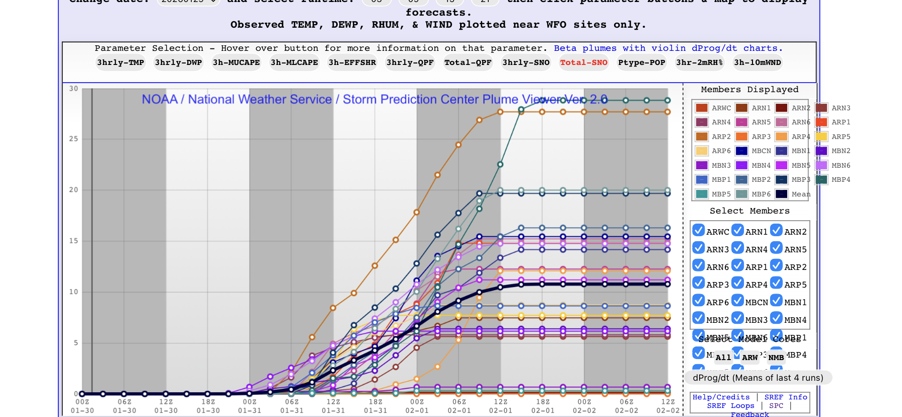
SREF plumes for RDU. 4 at 20+ 3 at 0. Crazy spread for 48 hours away
-
The “I bring the mojo” Jan 30-Feb 1 potential winter storm
Snowncanes replied to lilj4425's topic in Southeastern States
It’s just an echo chamber lol -
The “I bring the mojo” Jan 30-Feb 1 potential winter storm
Snowncanes replied to lilj4425's topic in Southeastern States
Check please -
The “I bring the mojo” Jan 30-Feb 1 potential winter storm
Snowncanes replied to lilj4425's topic in Southeastern States
Yes. Mostly close to the coast but there’s a good chance. WPC mentions it in their disco -
The “I bring the mojo” Jan 30-Feb 1 potential winter storm
Snowncanes replied to lilj4425's topic in Southeastern States
WPC put out a great discussion. A little long to quote so here’s the link. https://www.wpc.ncep.noaa.gov/discussions/hpcdiscussions.php?disc=qpfhsd -
The “I bring the mojo” Jan 30-Feb 1 potential winter storm
Snowncanes replied to lilj4425's topic in Southeastern States
Neutral at 48 centered over extreme NW GA. Looks like it’ll be a good run -
The “I bring the mojo” Jan 30-Feb 1 potential winter storm
Snowncanes replied to lilj4425's topic in Southeastern States
RGEM out to 30 closes off the low over Illinois/iowa and seems like it maybe has slightly better tilt at that range -
The “I bring the mojo” Jan 30-Feb 1 potential winter storm
Snowncanes replied to lilj4425's topic in Southeastern States
If I had to guess as to RAH’s reasoning, I think they see the trend and climo saying the low stays a little closer to the coast. Perhaps they’ve for seen that energy around Florida as fraudulent and thus doesn’t pull the low east quite as much. They’re definitely the professionals though. It won’t take much to set up a nice fgen band over the piedmont. Hopefully the upper low can tilt just a tad bit earlier, that will help too. -
The “I bring the mojo” Jan 30-Feb 1 potential winter storm
Snowncanes replied to lilj4425's topic in Southeastern States
I think it’s just saying im a new member. Ive been a long time lurker and just decided to start contributing to the conversation haha. But yeah it is really hard down there but I think this is the one that does it for y’all. Good luck! -
The “I bring the mojo” Jan 30-Feb 1 potential winter storm
Snowncanes replied to lilj4425's topic in Southeastern States
The NAM doesn’t run for another hour and fifteen minutes -
The “I bring the mojo” Jan 30-Feb 1 potential winter storm
Snowncanes replied to lilj4425's topic in Southeastern States
Really interesting to see RAH so bullish on central NC. Of note, they have Greenville NC at 98% to see more than 4 inches. And rdu at 87%. But they have rdu at 10% to see more than 18” and Greenville at 2%. I guess that shows where they are most uncertain about. -
The “I bring the mojo” Jan 30-Feb 1 potential winter storm
Snowncanes replied to lilj4425's topic in Southeastern States
Euro a decent tick west at H5 hr42. Heights a little flatter over NE -
The “I bring the mojo” Jan 30-Feb 1 potential winter storm
Snowncanes replied to lilj4425's topic in Southeastern States
EuroAI qpf. About the same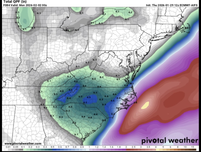
-
The “I bring the mojo” Jan 30-Feb 1 potential winter storm
Snowncanes replied to lilj4425's topic in Southeastern States
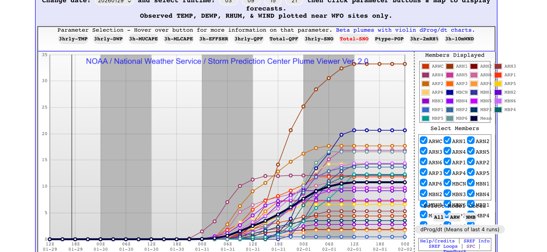
SREF plumes for RDU. Can we please stop the cliff diving? We have 9” on the nbm and a 34” storm on one of the sref members. It’s going to snow
-
The “I bring the mojo” Jan 30-Feb 1 potential winter storm
Snowncanes replied to lilj4425's topic in Southeastern States
Gfs looks better out to 54. Closes the low way earlier and is slightly west -
The “I bring the mojo” Jan 30-Feb 1 potential winter storm
Snowncanes replied to lilj4425's topic in Southeastern States
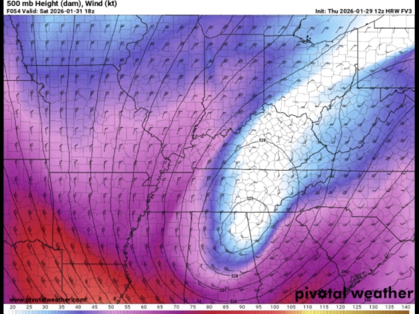
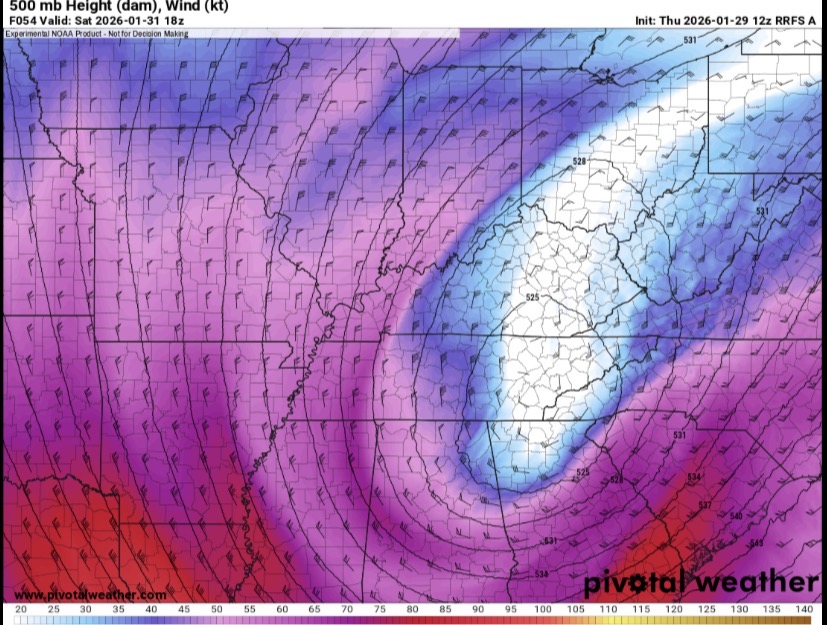
Adding the RRFS since that just gave us a big snow. Just trying to help people see the why behind the pretty color maps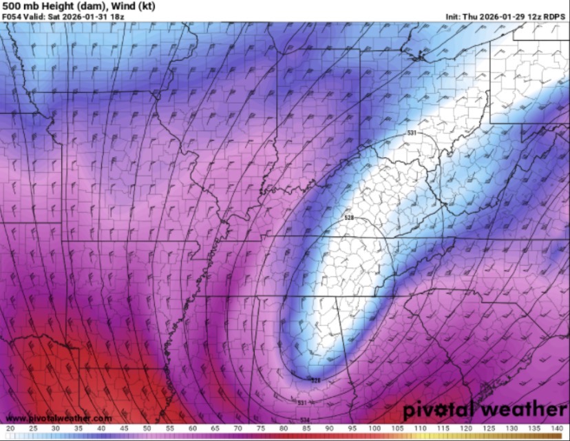
-
The “I bring the mojo” Jan 30-Feb 1 potential winter storm
Snowncanes replied to lilj4425's topic in Southeastern States
Just to illustrate how much we are splitting hairs… here is the 500mb view of the upper low from the FV3 and the RGEM. Nearly identical in placement but the tilt is just a tad bit better on the FV3 and the flow is more onshore and pulls the coastal in just a tiny bit more. Ideally we’d have this thing closing off and going neutral in central Tennessee/north Alabama and we aren’t terribly far from that. But that’s what would give us our best shot at board wide happiness lol.
-
The “I bring the mojo” Jan 30-Feb 1 potential winter storm
Snowncanes replied to lilj4425's topic in Southeastern States
Saturday morning haha. Hopefully the models can figure it out a little before then.