TalcottWx
-
Posts
28,808 -
Joined
Content Type
Profiles
Blogs
Forums
American Weather
Media Demo
Store
Gallery
Everything posted by TalcottWx
-

March 10-11 light snow threat for SW New England.
TalcottWx replied to Sey-Mour Snow's topic in New England
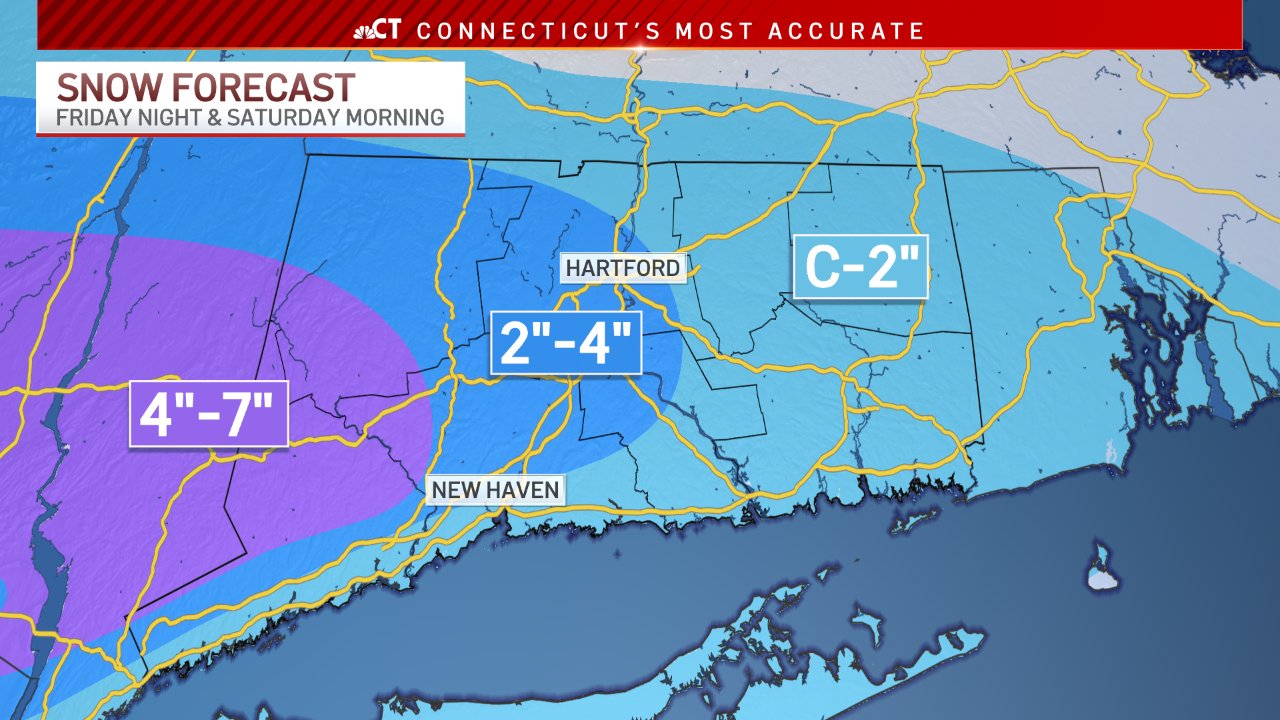
Ryan's map
-
March 10-11 light snow threat for SW New England.
TalcottWx replied to Sey-Mour Snow's topic in New England
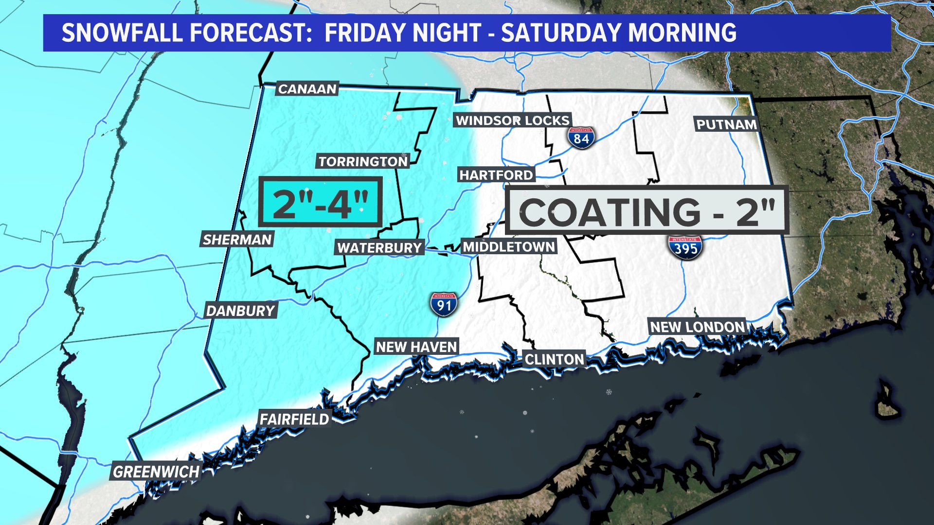
Fox 61
-
March 10-11 light snow threat for SW New England.
TalcottWx replied to Sey-Mour Snow's topic in New England
My guess is 3-6" from you on south and away from the sound out to w CT... Obviously you well see less but that range covers a lot -
The last hurrah? Putting all the eggs in the Tuesday 3/14 basket
TalcottWx replied to Ginx snewx's topic in New England
Our storm has been 5 days out since Christmas -
March 10-11 light snow threat for SW New England.
TalcottWx replied to Sey-Mour Snow's topic in New England
We are such a weird middle ground. Especially Simsbury. Goes like 50' to 1k ft lol -
The last hurrah? Putting all the eggs in the Tuesday 3/14 basket
TalcottWx replied to Ginx snewx's topic in New England
Good news is the guy is going to make it. -
March 10-11 light snow threat for SW New England.
TalcottWx replied to Sey-Mour Snow's topic in New England
Lol not used to being close to these borders -
March 10-11 light snow threat for SW New England.
TalcottWx replied to Sey-Mour Snow's topic in New England
Nothing in Hartford County? Wtf? -
March 10-11 light snow threat for SW New England.
TalcottWx replied to Sey-Mour Snow's topic in New England
-
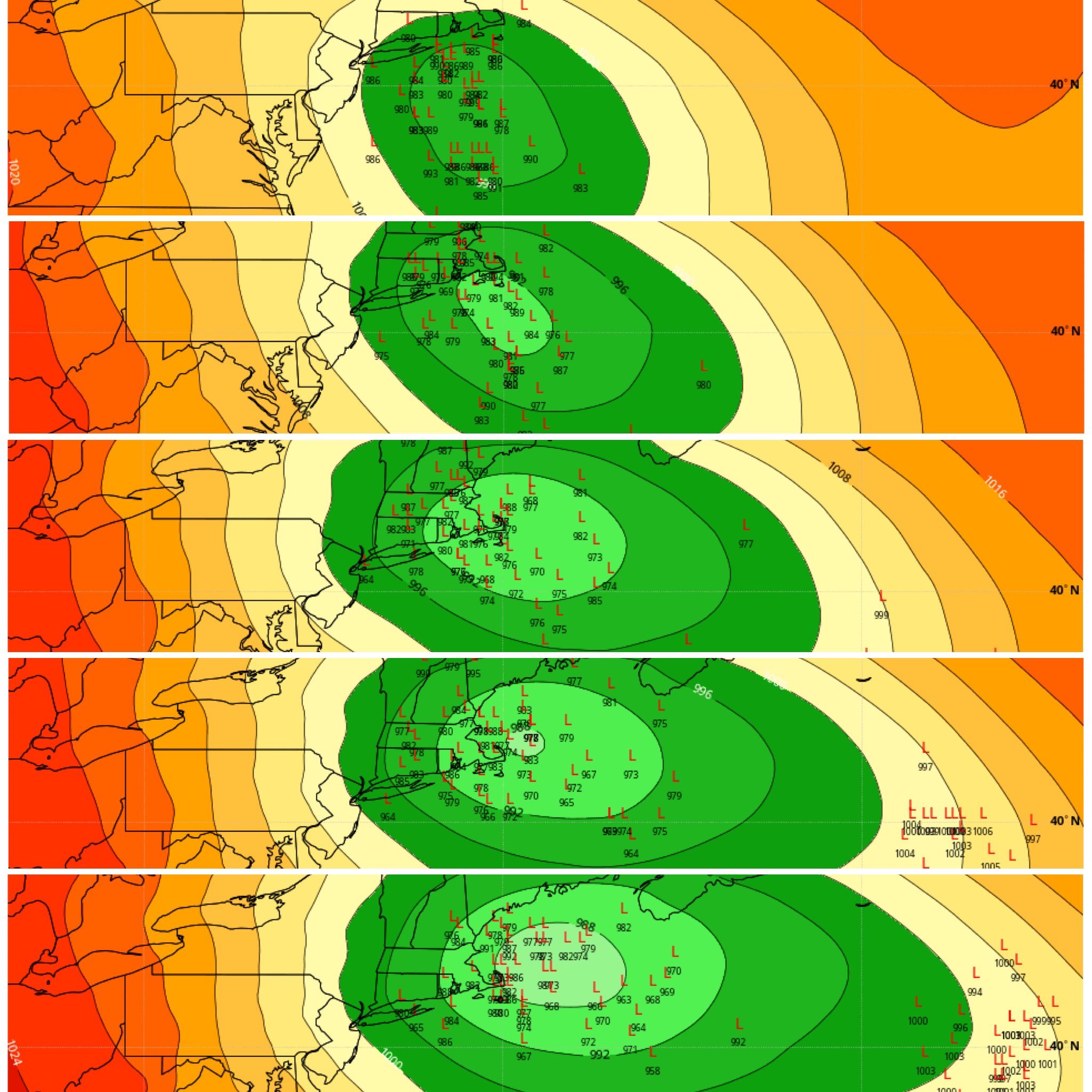
The last hurrah? Putting all the eggs in the Tuesday 3/14 basket
TalcottWx replied to Ginx snewx's topic in New England
Eweather just posted this on Twitter. Eps ensembles, from 6z Tuesday to 6z Wednesday, top to bottom.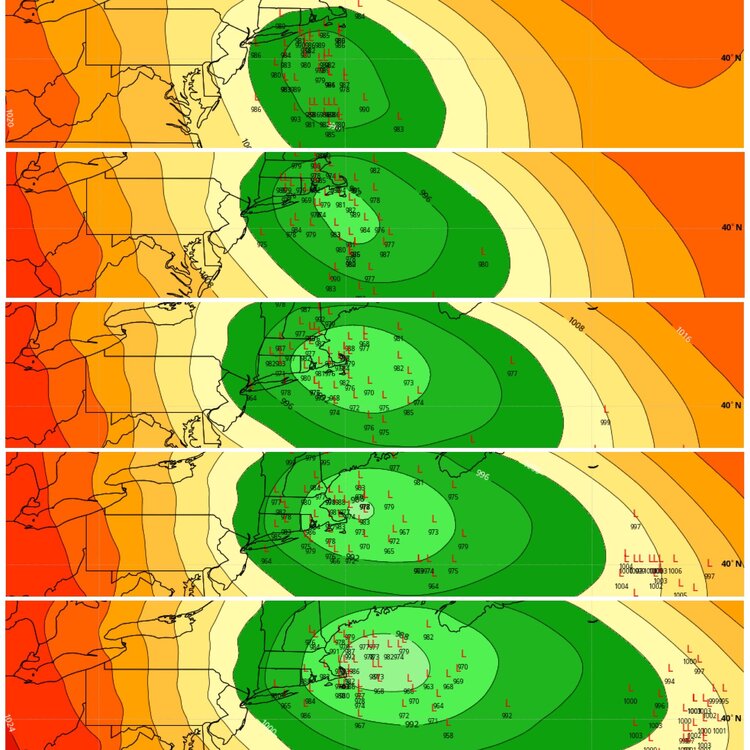
-
March 10-11 light snow threat for SW New England.
TalcottWx replied to Sey-Mour Snow's topic in New England
It's OK I don't exist. -
March 10-11 light snow threat for SW New England.
TalcottWx replied to Sey-Mour Snow's topic in New England
Definitely what is being watched. -
The last hurrah? Putting all the eggs in the Tuesday 3/14 basket
TalcottWx replied to Ginx snewx's topic in New England
Would rather be here vs E Mass.... -
March 10-11 light snow threat for SW New England.
TalcottWx replied to Sey-Mour Snow's topic in New England
Just posted it above. -
March 10-11 light snow threat for SW New England.
TalcottWx replied to Sey-Mour Snow's topic in New England
-
March 10-11 light snow threat for SW New England.
TalcottWx replied to Sey-Mour Snow's topic in New England
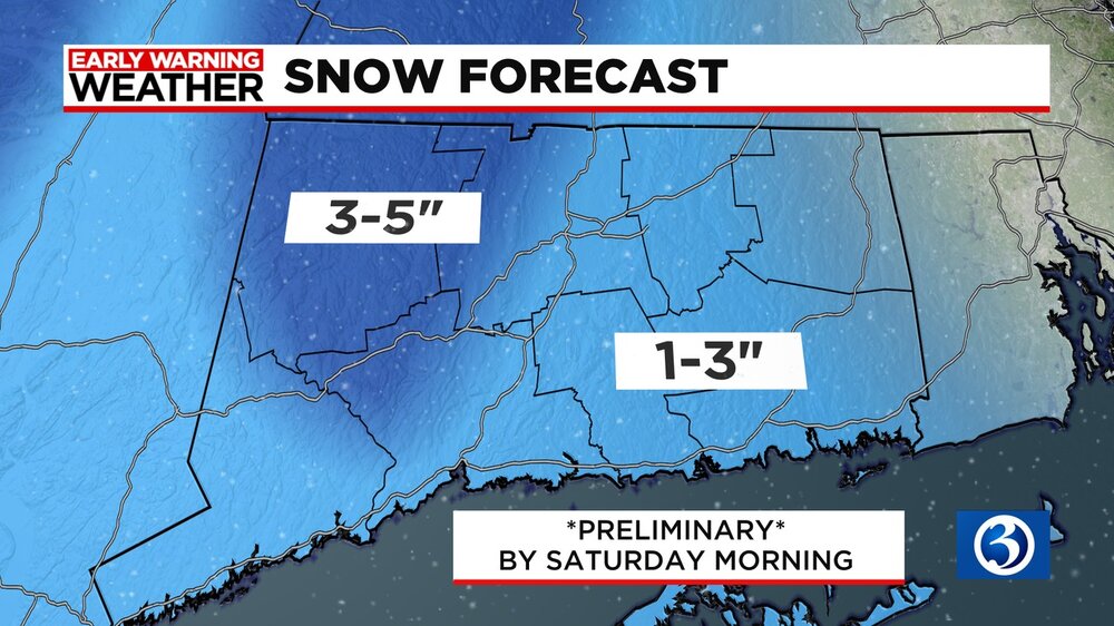
We just upped our snowfall maps for the noon. -
The last hurrah? Putting all the eggs in the Tuesday 3/14 basket
TalcottWx replied to Ginx snewx's topic in New England
I have a bad feeling about this one. Leaning toward thinking it's rain for us vs. a whiff. Hope we pull it off. -
March 10-11 light snow threat for SW New England.
TalcottWx replied to Sey-Mour Snow's topic in New England
I thought I smoked bath salts before looking at that run. Awesome. -
The last hurrah? Putting all the eggs in the Tuesday 3/14 basket
TalcottWx replied to Ginx snewx's topic in New England
Probably 6-12" in Tblizz house and 0" in Weymouth -
The last hurrah? Putting all the eggs in the Tuesday 3/14 basket
TalcottWx replied to Ginx snewx's topic in New England
Noted for the record. -
The last hurrah? Putting all the eggs in the Tuesday 3/14 basket
TalcottWx replied to Ginx snewx's topic in New England
Just say patient for now. I won't be super concerned unless this trend continues into tomorrow. -
The last hurrah? Putting all the eggs in the Tuesday 3/14 basket
TalcottWx replied to Ginx snewx's topic in New England
I am so confused from Ryan's posts to seeing this. -
March 10-11 light snow threat for SW New England.
TalcottWx replied to Sey-Mour Snow's topic in New England
I take any snow. -
Hold me
-
The last hurrah? Putting all the eggs in the Tuesday 3/14 basket
TalcottWx replied to Ginx snewx's topic in New England
Tip gone wild!