simbasad2
-
Posts
41 -
Joined
-
Last visited
Content Type
Profiles
Blogs
Forums
American Weather
Media Demo
Store
Gallery
Everything posted by simbasad2
-
E PA/NJ/DE Spring 2026 Obs/Discussion
simbasad2 replied to PhiEaglesfan712's topic in Philadelphia Region
Surprised nobody is mentioning the potential severe weather activity on Day-4 -
E PA/NJ/DE Winter 2025-26 Obs/Discussion
simbasad2 replied to LVblizzard's topic in Philadelphia Region
Temperatures downtrended at the last minute. Undermodeled CAD, as always.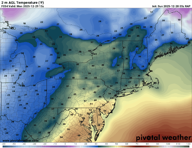
-
E PA/NJ/DE Winter 2025-26 Obs/Discussion
simbasad2 replied to LVblizzard's topic in Philadelphia Region
For the rain total folks, I'm at 0.07" on the day in West Chester, PA. Line looks like it's about done moving through, so that's probably about where I'll finish. I'll have an update if I record more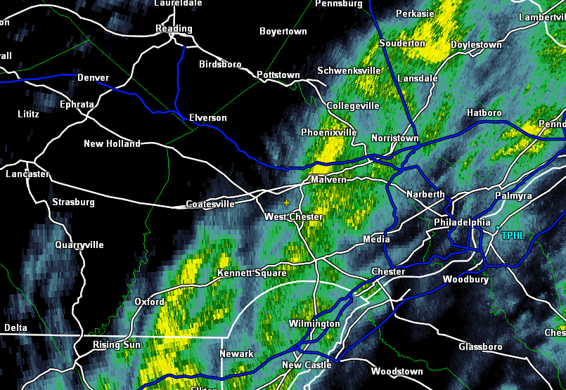
-
E PA/NJ/DE Winter 2025-26 Obs/Discussion
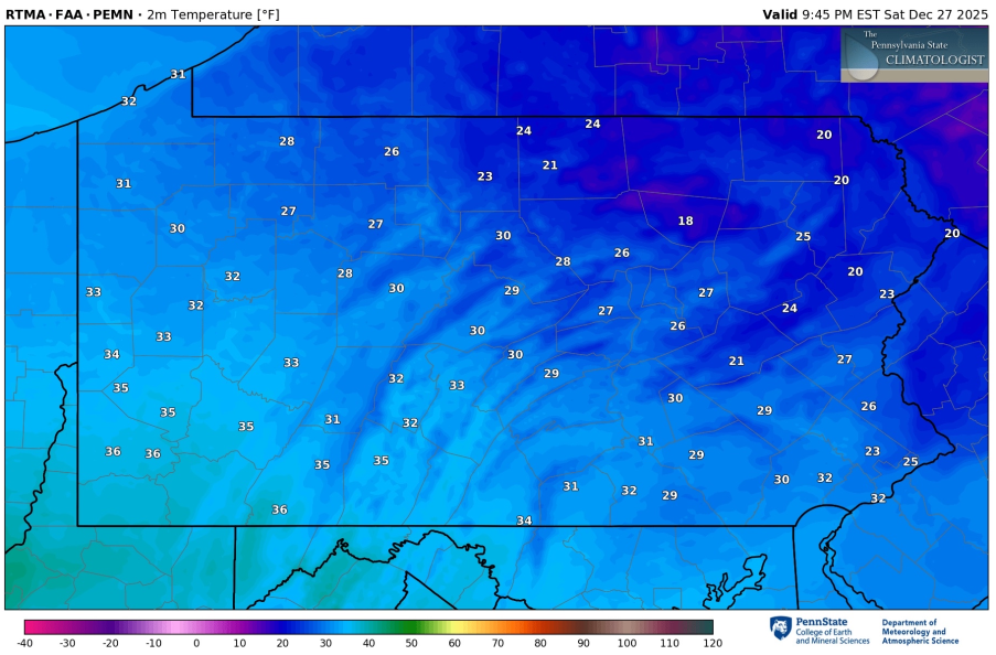
simbasad2 replied to LVblizzard's topic in Philadelphia Region
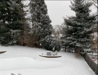
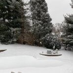
Very low flow at 925mb has allowed for a near-stationary low-level cloud deck to develop. This is reflecting on the temp maps, where it is in the low 20s near Philadelphia and Bucks county, but holding around 30 degrees here in Chester County. Neat stuff
-
Saturday night/Sunday 12/13-12/14 Jawn
simbasad2 replied to Ralph Wiggum's topic in Philadelphia Region
Agreed. Was originally thinking that it was going to be in South Jersey but overnight guidance has lead me to believe it'll be somewhere right along I-95. -
Saturday night/Sunday 12/13-12/14 Jawn
simbasad2 replied to Ralph Wiggum's topic in Philadelphia Region
What the hell is this 00z NAM lmfao... I think this solution is unlikely at the moment so this doesn't worry me, but this is a really funny snow map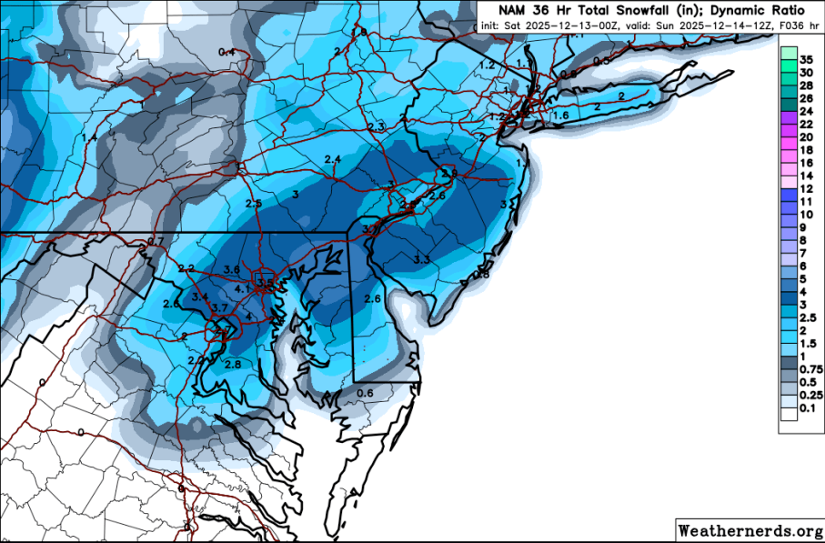
-
Saturday night/Sunday 12/13-12/14 Jawn
simbasad2 replied to Ralph Wiggum's topic in Philadelphia Region
Here's my first call, going a little bit on the aggressive side with the band that sets up over I-95. I think that the regional models (NAM/RDPS/RRFS etc..) have a better handling on how this storm will do has there will be important mesoscale features determining total snowfall that the global models just aren't able to resolve. My thinking is that hypothetically if the banding can really get going along I-95 then NW and SE areas wouldn't do as well because of the subsidence that would result -
Saturday night/Sunday 12/13-12/14 Jawn
simbasad2 replied to Ralph Wiggum's topic in Philadelphia Region
Created sort of a "0.5th call" as we approach around 60 hours from precipitation onset. Don't pay attention to the numbers on the side (I even crossed it out) just focus on the shade of the color. While not a full forecast, it does outline some aspects of my thoughts such as 1. Snow more favored for I-95 and surrounding suburbs, but slightly less confidence as you travel northbound on I-95 closer to NYC 2. Snow less likely as you head towards the far northwest suburbs and the shore 3. Despite these differences, the entire map is shaded as I think this will be an event where everyone in the region has a very good shot at getting some sort of snowfall -
12/3 Snow/Sleet/Mix Bag of Everything Discussion/OBS
simbasad2 replied to Mikeymac5306's topic in Philadelphia Region
Measured 0.2" of snow/sleet/slush this morning. Though, this was after the changeover, so it's possible there was more that was melted -
12/3 Snow/Sleet/Mix Bag of Everything Discussion/OBS
simbasad2 replied to Mikeymac5306's topic in Philadelphia Region
Final call for this storm, shifting everything to the north and west by a ton. The storm keeps trending slower and slower AND warmer, both horrible for our storm for everyone. I'm thinking I-95 will start as a wintery mix and areas just NW of 95 will start as some flakes before quickly shifting over. Far NW suburbs + mountains will still likely see some decent accumulations, but I removed the 6-8 contour for the poconos as totals downtrend even for up there. Schuylkill, Carbon, and Monroe counties are the only areas on this map that will remain all snow. Still can't rule out isolated 6"+ for those areas but not widespread enough to add the 6-8 contour back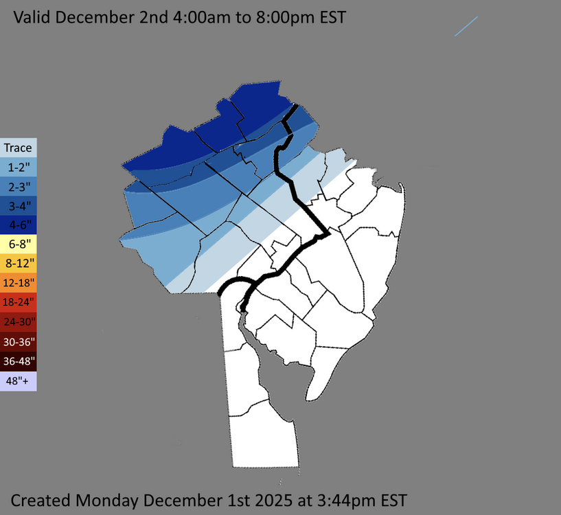
-
12/3 Snow/Sleet/Mix Bag of Everything Discussion/OBS
simbasad2 replied to Mikeymac5306's topic in Philadelphia Region
I'm really disliking the overnight trends for I-95 and the immediate suburbs. 12z NBM has literally no snowfall for the entire urban corridor (Eastern Chester, Eastern Montgomery, Lower Bucks NWS forecast zones and points SE). This storm is reminding me of the one we had around this time in December 2019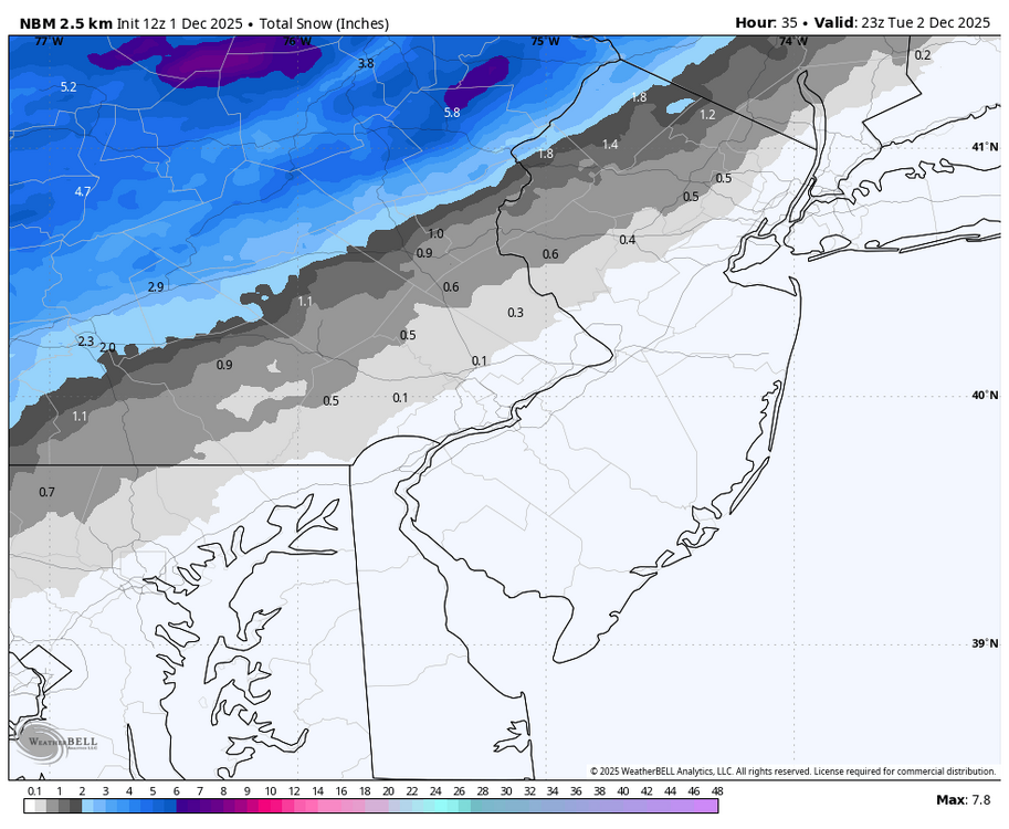
-
E PA/NJ/DE Winter 2025-26 Obs/Discussion
simbasad2 replied to LVblizzard's topic in Philadelphia Region
Thank you!! -
12/3 Snow/Sleet/Mix Bag of Everything Discussion/OBS
simbasad2 replied to Mikeymac5306's topic in Philadelphia Region
Reposting this here -
E PA/NJ/DE Winter 2025-26 Obs/Discussion
simbasad2 replied to LVblizzard's topic in Philadelphia Region
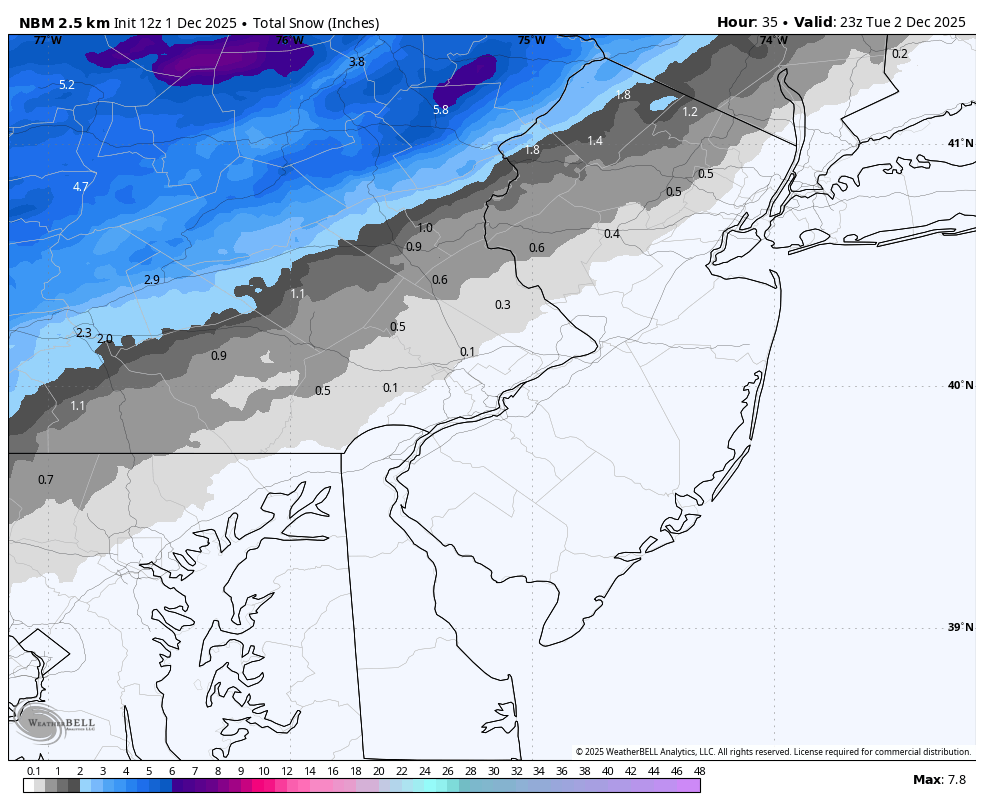
Here are my thoughts regarding totals for the region for Tuesday. Keeping the heavier snow to the northwest with a sharp gradient as you approach I-95. I'm thinking I might shift this even farther northwest in future updates but we'll see -
E PA/NJ/DE Autumn 2025 Obs/Discussion
simbasad2 replied to PhiEaglesfan712's topic in Philadelphia Region
All the other regional sub forums have done it, I think a board for the December 2nd storm should be created sometime today or tomorrow -
E PA/NJ/DE Autumn 2025 Obs/Discussion
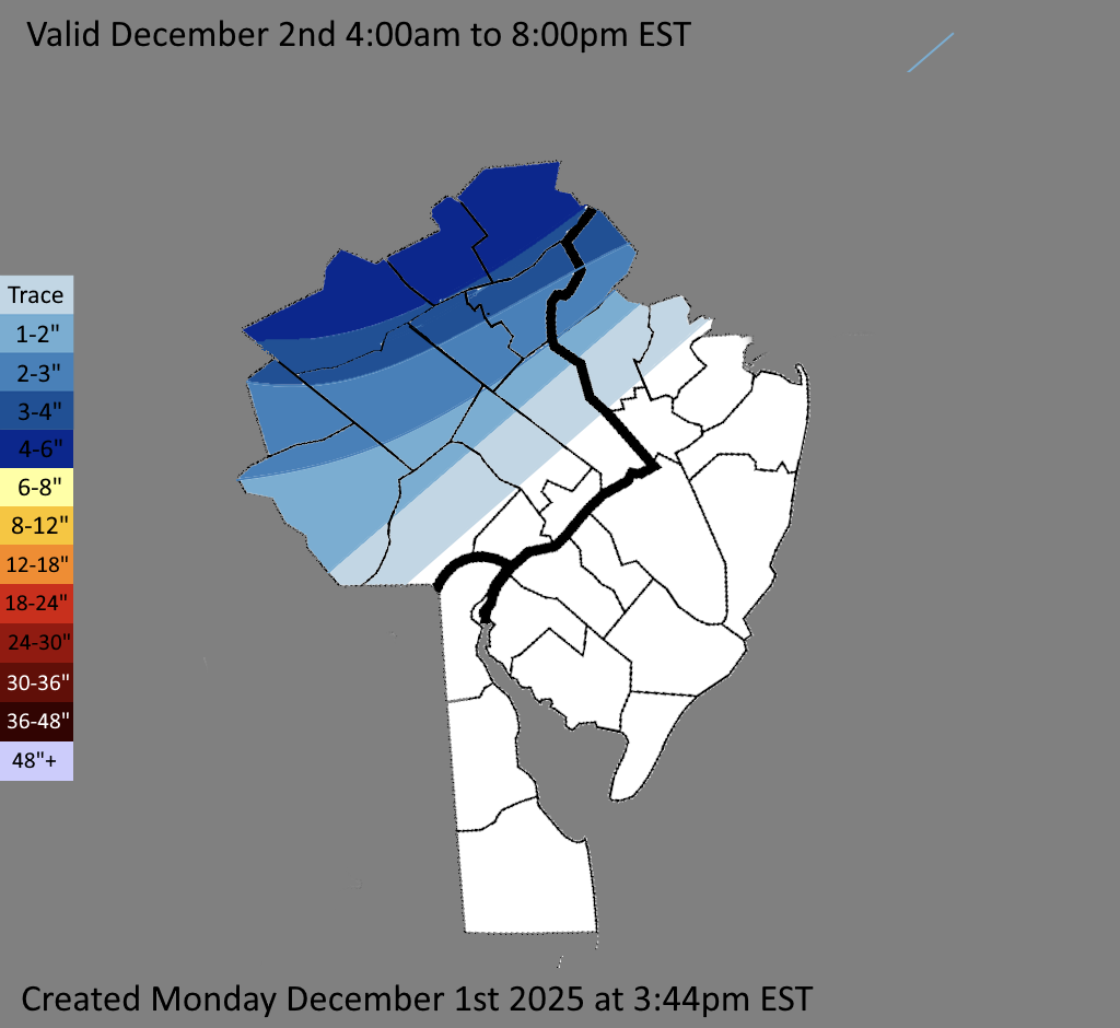
simbasad2 replied to PhiEaglesfan712's topic in Philadelphia Region
Drew up this quick map to outline some of my thoughts for this storm. Constructive feedback is appreciated! Blue - All Snow expected, accumulations around 2-4" localized 4"+ Pink - Snow, mix, and rain expected. A sharp cutoff will develop here and a slushy 0-2" will fall before changing over to rain, some of which could be heavy Green - All rain. Perhaps maybe a light mix at onset but this will quickly change over. Air temps closer to the shore could even reach into the lower 50s. Some rain could be heavy at times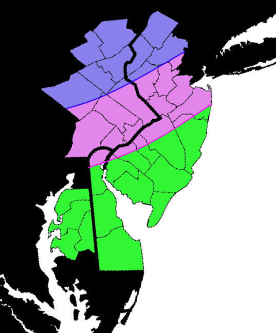
-
Gonna put this here too.. The uber northwest all rain solution just seems unlikely to me
-
E PA/NJ/DE Autumn 2025 Obs/Discussion
simbasad2 replied to PhiEaglesfan712's topic in Philadelphia Region
Maybe I sound weenie but I'll say it: When the Euro and GFS disagree on a storm like this, 9 times out of 10 the Euro will end up being correct -
Oh yeah I know which one you're talking about, 1/19. It actually did pretty well in the medium range compared to other guidance which had the storm like 100 miles off the coast. Though I do agree it did pretty bad in the short range like you said, but it's not like any other global model did much better for that storm though
-
The Euro nailed like every storm last year, no? Other than 2/20 of course but nobody got that one right
-
E PA/NJ/DE Autumn 2025 Obs/Discussion
simbasad2 replied to PhiEaglesfan712's topic in Philadelphia Region
12z GFS and ECMWF showing similar solutions of a I-95 and NW hit. While it's still certainly possible, the chance that this storm is suppressed is appearing increasingly more unlikely and the main worry shifts to whether or not thing thing tracks too far north. The TPV over the Hudson Bay is so poorly sampled so this will be a high uncertainty event until precip onset, so don't bet all your money on one solution -
E PA/NJ/DE Autumn 2025 Obs/Discussion
simbasad2 replied to PhiEaglesfan712's topic in Philadelphia Region
New to Americanwx so I'm still trying to figure things out here. How far usually 'til a storm thread is made? -
The "Worlds Most Consistent Model" with a 200 mile jump to the NW. Anyway I love the changes I'm seeing on the 18z suite so far, certainly feeling more optimistic about next week's threat compared to yesterday.
-
Central PA Fall Discussions and Obs
simbasad2 replied to ChescoWx's topic in Upstate New York/Pennsylvania
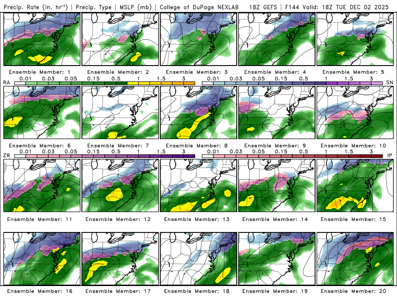
That is quite the signal from the 18z GEFS -
E PA/NJ/DE Autumn 2025 Obs/Discussion
simbasad2 replied to PhiEaglesfan712's topic in Philadelphia Region
18z GEFS coming in with a pretty evenly distributed amount of members going for snow, too far north and rain, and too far south and miss. The track of this storm and its behavior is dependent on many factors, namely timing, track of the shortwave as it rounds the base of the TPV lobe, and how strong the TPV can actually suppress this thing south. It is certainly possible that the TPV suppresses this storm too far south which is what the Euro AI is showing. I think the GFS solution of a changeover to rain is unrealistic, and a much more likely fail mode is that the shortwave is too flat and goes out to sea. The 18z Euro should be in range tonight if not for the early morning 06z run, so we'll have more guidance to go off of for this 18z suite