

AirNelson39
-
Posts
1,052 -
Joined
-
Last visited
Content Type
Profiles
Blogs
Forums
American Weather
Media Demo
Store
Gallery
Posts posted by AirNelson39
-
-
Hi Res snow- not compete yet for northern areas
(11).thumb.png.9f2fb4899ec0212364f70004a2555bee.png)
I’d say this is closer to reality especially for Piedmont and foothills. We’ll be lucky to see another dusting and if we do it’ll be gone within a few hours. After the way things have gone all winter I just can’t get excited for any model run. Depressing-
 3
3
-
-
Nothing coming down in NW Catawba here in Hickory, despite the radar returns indicating otherwise. The direction of this flow is different than normal, though, which may explain the returns that are breaking containment. It's almost due north, just a few degrees west of that.
Sent from my moto e5 supra using Tapatalk
Saw a few flurries under those radar returns last night after 10pm here in SE Caldwell County. Was hoping for more given the returns. Looks like we may have another shot at some more flurries today with more returns breaking containment.-
1
-
-
Just like I suspected 33 and rain in Hickory. Sad stuff.
-
Different world here just 45 mins to your west in McDowell. Hovering below 30 with an inch+ still on the ground
Pretty jealous right now! -
Temp steady at 33, the dusting from earlier is gone. Looking like 33 and rain overnight. Weather apps have done a great job nailing the temps here. NWS forecasts aren’t looking good for NW Piedmont.
-
Dusting here in Hickory (Caldwell County side), nothing on the roads. Looks like we are on the very tail end too. Might be all the wrote in regards to snow on this one.
-
3
-
-
Not sure what model/models WeatherUnderground uses for their hourly forecast but they don’t have Hickory getting below 34 tonight. Little concerning on how we’ll get any ZR accrual with that. I know it’s an app but the models are clearly not impressed with surface temps in this area and the temp forecasts are typically pretty spot on. These borderline events never pan out.
-
Brad P isn’t feeling it especially for the foothills. I’m not feeling this setup either and think the models are way overdone.

-
That'd be sweet if I was still living in my old home of Scranton, Pa. :-/
Good grief. Someone take the pens away from him. Pathetic.-
 1
1
-
-
Heavy, half dollar size flakes now.

-
5
-
-
FINALLY all snow and moderate/heavy in southern Caldwell. No accumulations yet.
-
2
-
-
This is why you don’t trust your phone apps. This is still the current forecast from my accuweather app. There’s absolutely zero snow on the ground.

-
 1
1
-
 1
1
-
-
Half an inch before it melted. Biggest bust in a long long time! On to the next storm.
Where are you located? Guessing you aren’t in Boone lol. Here in Granite we didn’t even have 1/8” an inch before it melted lol -
Not seeing how southern Caldwell gets any accumulations out of this. Heading towards a major bust.
-
1
-
-
Going to take some seriously heavy snow to accumulate here I’m afraid. I’m thinking 1-2” in hickory is being pretty optimistic. Will be lucky to see an inch if we can’t get accumulations in the middle of the night.
-
1
-
-
Radar depiction is showing all snow but a heavy rain/sleet/snow mix southern Caldwell County. Thought it would have changed fully by now in these heavier bands.
-
35 degrees and mostly rain still here at the southern tip of Caldwell County. Has had snow mixed in for over an hour now but is really struggling to changeover to all snow.
-
Temps being stubborn, radar looks horrible, thinking this may turn out to be a daylight event. Peace out until 6am.
It’s been modeled as mostly a daytime event for the last 24 hours or more. The brunt of the snow has and is suppose to come from the ULL which isn’t anywhere close yet.-
1
-
-
Also, don’t think it was Brick that had the healing skies theory...can’t remember the user name, but he/she was an odd character.
WilkesboroDude said the skies hadn’t had time to heal for a decent event lol.-
2
-
1
-
-
^ Six-ten inches of snow for Hickory? I hope DT is correct, but I'm not banking on that.
I don’t think he’s ever got a map right for anyone south of VA. He’s made some hideous maps like this in the past where he’s always wayyyy to bullish.-
3
-
-
CMC is a I40 crush job.
Pics please. Would like to save for post storm reference -
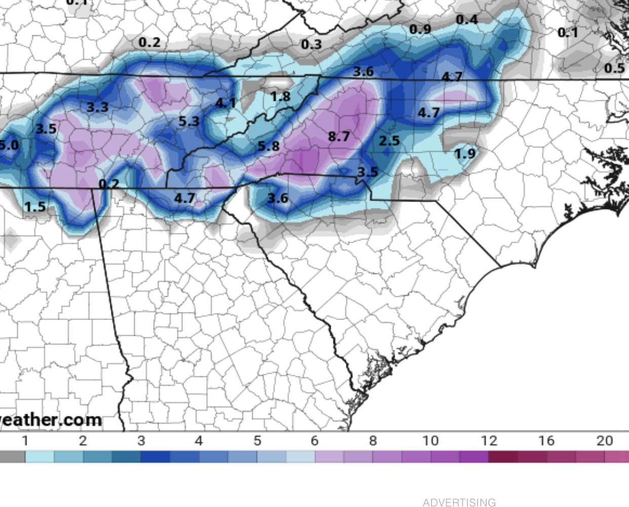
18z gfs v16 snowfall amounts seems slightly east of NAM and euro consensus, doesn’t target mountains as much . We won’t see 10:1 ratios but map gives idea of QPF instead of actual ground truth accumulation.

Wow! What a change from the GFS. It has finally joined virtually all other modeling. Goes to show the GFS might be one of the worst models right now, if the consensus is to be believed.-
1
-
-
-
(11).png.a095ba54bdbc28da1c90b2918c4a6b12.png)


2/6/-2/7 Snow Threat
in Southeastern States
Posted
I believe it was showing a major ice storm for I-40 corridor less than 12 hours out with last system and we had 34 and rain all day. That left a pretty bad taste in my mouth for the RGEM