SabreAce33
-
Posts
333 -
Joined
-
Last visited
Content Type
Profiles
Blogs
Forums
American Weather
Media Demo
Store
Gallery
Everything posted by SabreAce33
-
Southern MD / Lower Eastern Shore weather discussion
SabreAce33 replied to AnEndlessMaze's topic in Mid Atlantic
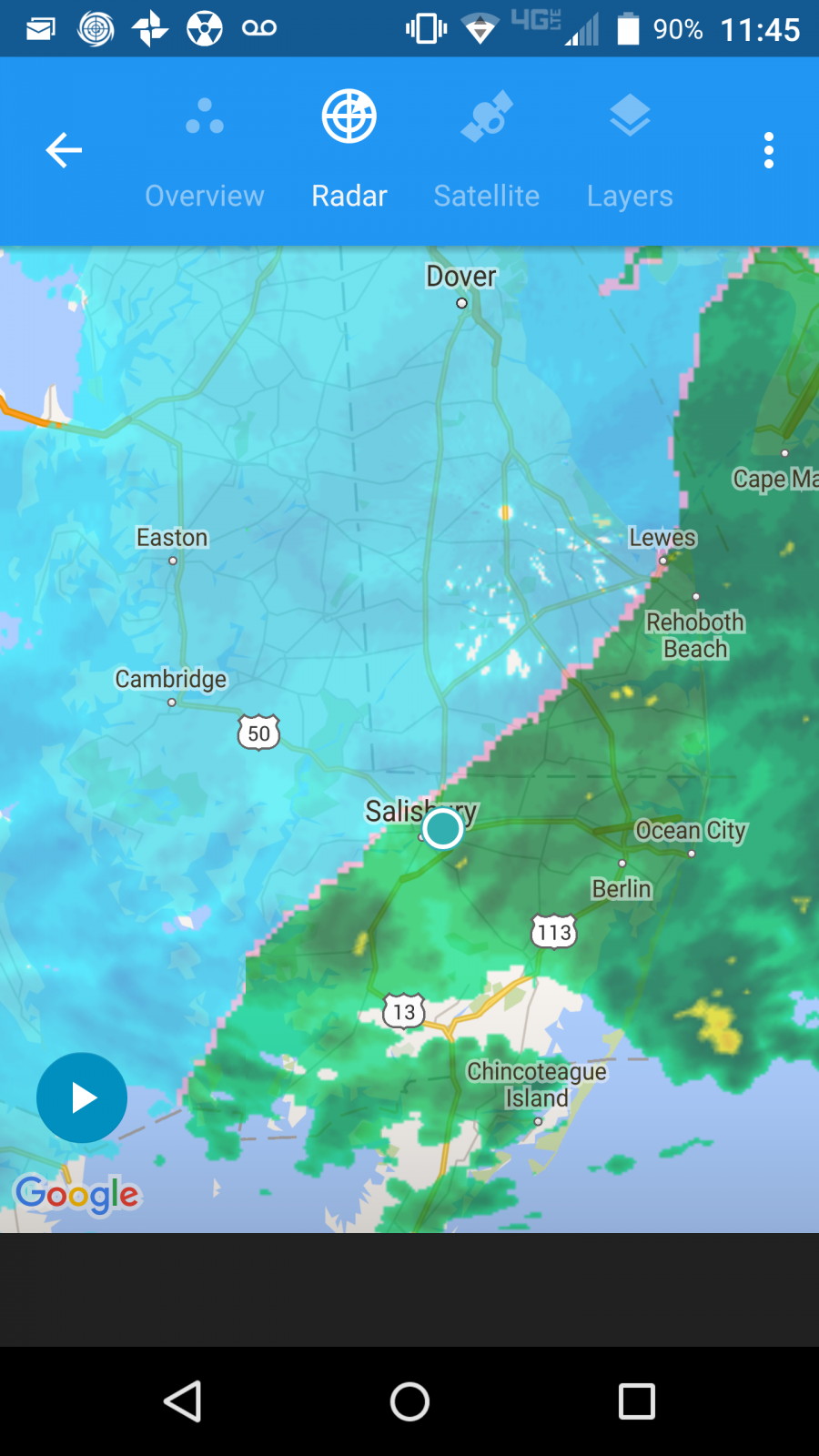
Image sums it up for SBY. 30 miles would have made an enormous difference. Ultimately, GFS/NAM were correct and the Euro was not.
-
Southern MD / Lower Eastern Shore weather discussion
SabreAce33 replied to AnEndlessMaze's topic in Mid Atlantic
That sums it up... -
Southern MD / Lower Eastern Shore weather discussion
SabreAce33 replied to AnEndlessMaze's topic in Mid Atlantic
Mostly rain, touch of sleet as of 30 mins ago. Only 4.5 or so on the ground. Off to bed. -
Southern MD / Lower Eastern Shore weather discussion
SabreAce33 replied to AnEndlessMaze's topic in Mid Atlantic
Lucky you! Temp rising here. EDIT: First big gust out of the ENE just now, would explain the rising temps. -
Southern MD / Lower Eastern Shore weather discussion
SabreAce33 replied to AnEndlessMaze's topic in Mid Atlantic
We picked up a fast inch, then flake size decreased along with rates. A bit more modest now. -
Southern MD / Lower Eastern Shore weather discussion
SabreAce33 replied to AnEndlessMaze's topic in Mid Atlantic
Right, I was considering the wind too, but you're right, Wakefield is always so conservative. -
Southern MD / Lower Eastern Shore weather discussion
SabreAce33 replied to AnEndlessMaze's topic in Mid Atlantic
Ah hah, here: -
Southern MD / Lower Eastern Shore weather discussion
SabreAce33 replied to AnEndlessMaze's topic in Mid Atlantic
Where did you see this? Neither the WSW or my point forecasts reflect that. Also, would that not put us in Blizzard Warning territory? -
Southern MD / Lower Eastern Shore weather discussion
SabreAce33 replied to AnEndlessMaze's topic in Mid Atlantic
Euro says 14" of snow for SBY according to Bob Chill. Two camps. Not sure what the temp biases are. EDIT: Euro is usually a little warm. Let that be the case and SBY could be sitting on a foot plus. Wonder how much the rain will knock down. -
Southern MD / Lower Eastern Shore weather discussion
SabreAce33 replied to AnEndlessMaze's topic in Mid Atlantic
Correction: Looks like 9" on the GFS, low-res map fail. -
Southern MD / Lower Eastern Shore weather discussion
SabreAce33 replied to AnEndlessMaze's topic in Mid Atlantic
Did it? I never saw the maps for the Euro. A 30-50 mile shift is not at all unusual with a big dynamic system like this. 12Z GFS came in cold, looking like 10-12 for SBY from the low-res clown map. -
Southern MD / Lower Eastern Shore weather discussion
SabreAce33 replied to AnEndlessMaze's topic in Mid Atlantic
What a nasty mess it's going to be. If we have 4-6 inches of wet snow saturating with rain at the time of peak winds, it's going to be a bad time. -
Southern MD / Lower Eastern Shore weather discussion
SabreAce33 replied to AnEndlessMaze's topic in Mid Atlantic
Unless the Euro wins out, I think we're stuck with a nasty mixed bag here in SBY at least. -
Southern MD / Lower Eastern Shore weather discussion
SabreAce33 replied to AnEndlessMaze's topic in Mid Atlantic
My best guess is 3-6 followed by a period of rain, followed by another 3-6 at the end. Total snow on the ground at the end, maybe five inches? That's entirely unscientific and based on my own hunch. -
Southern MD / Lower Eastern Shore weather discussion
SabreAce33 replied to AnEndlessMaze's topic in Mid Atlantic
Let us not troll until we have something verifiable to troll about. -
Southern MD / Lower Eastern Shore weather discussion
SabreAce33 replied to AnEndlessMaze's topic in Mid Atlantic
Poor snowdude! Two camps it seems. GFS gives a couple of inches and a lot of rain, Euro gives us a bunch of snow with some mixing and rain, but not a ton. -
Southern MD / Lower Eastern Shore weather discussion
SabreAce33 replied to AnEndlessMaze's topic in Mid Atlantic
Looks great in SOMD! -
Southern MD / Lower Eastern Shore weather discussion
SabreAce33 replied to AnEndlessMaze's topic in Mid Atlantic
NAM came in west over the last two runs and shows us dry slotted at times, reducing our totals to ~4 inches. Yeah, it's the NAM,but it's in its wheelhouse now. Curious to see if GFS does the same. -
Southern MD / Lower Eastern Shore weather discussion
SabreAce33 replied to AnEndlessMaze's topic in Mid Atlantic
About the same here in SBY. Schools closed. Maybe they looked at DC's mess last night... -
Southern MD / Lower Eastern Shore weather discussion
SabreAce33 replied to AnEndlessMaze's topic in Mid Atlantic
Tough forecast for you over the next 24 hours. Models still call for ~10 inches in SBY, but when does that fall? How much gets knocked down by the rain? How much comes on the back end? Etc., etc., etc. There's a reason NWS is so slow to decide on how to handle us a lot of the time. -
Southern MD / Lower Eastern Shore weather discussion
SabreAce33 replied to AnEndlessMaze's topic in Mid Atlantic
I think it's related to the quantity of warm air we're talking about. The low is simply too far inshore for us. But I like that you're keeping the dream alive! Remember, we only need 30 miles. -
Southern MD / Lower Eastern Shore weather discussion
SabreAce33 replied to AnEndlessMaze's topic in Mid Atlantic
I believe warm air aloft is a concern with the easterly flow we're expecting. -
Southern MD / Lower Eastern Shore weather discussion
SabreAce33 replied to AnEndlessMaze's topic in Mid Atlantic
This will be our problem. I would expect a good thump up front, brief mix, extended rain, brief mix, then snow again at the backend. I would imagine the only accumulation will be a base layer of slush and then whatever comes at the end. -
Southern MD / Lower Eastern Shore weather discussion
SabreAce33 replied to AnEndlessMaze's topic in Mid Atlantic
I suspect that's more likely to be accurate. How often do we see bay counties at 14+ inches(obviously throwing out numbers over 24" at this point)? I just don't want 24 miserable hours of cold rain... -
Southern MD / Lower Eastern Shore weather discussion
SabreAce33 replied to AnEndlessMaze's topic in Mid Atlantic
00z GFS still likes the 8-12 range for SBY, but perhaps more importantly: