

GramaxRefugee
-
Posts
1,595 -
Joined
-
Last visited
Content Type
Profiles
Blogs
Forums
American Weather
Media Demo
Store
Gallery
Posts posted by GramaxRefugee
-
-
1 hour ago, PrinceFrederickWx said:
I just accept that met summer is now Jun 1 - Sept 30. I think BWI’s new 1991-2020 normal is almost two degrees warmer than 1981-2010 for September.
1.4
-
.07" overnight.
-
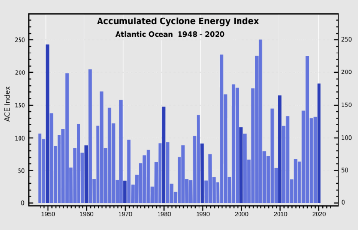
If you look at a chart of Atlantic ACE Index, (below hopefully), some of the best winters had low ACE. But I think RaindanceWX is looking at La Nina years only. Which, as we all know, are usually pretty woeful winters for snow lovers, with some exceptions. Looks like the snowy winters of 2013, 2014, 2015 all had low ACE
-
ACE (Accumulated Cyclone Energy) is a measure of tropical cyclone energy, but I'm probably not the best guy to elaborate except to say this...
The way I look at it, things like the number of major hurricanes, or number of named storms, etc. are all subjective, since they'll name a thunderstorm these days. But the total accumulated energy is more absolute, so might be a good measure of how active the hurricane season is.
-
On 9/5/2021 at 8:41 PM, raindancewx said:
It doesn't work reliably in Baltimore/DC and south, but in La Nina years, ACE over 150 is almost a pre-requisite Summer trait for the big NE snowy winters. Pretty sure there are no La Ninas more than +20% or +30% for NYC/Philly snow totals since 1930 when ACE is not at least 150. I know you guys don't live up there, but if you hit 150 ACE in the Summer, you at least have a shot at a lot of Nor'easters with blocking.
The big ACE La Nina years since 1931-32 are these, in order of highest ACE:
1933, 2005, 1995, 2017, 1950, 1998, 2020, 1999, 2010, 1955, 1964.
If you use Baltimore, the 11-year average snowfall is (44.6+19.6+62.5+15.4+6.2+15.2+10.9+26.1+14.4+18.1+18.6)/11 --> 22.9, and essentially a coin flip for near-normal to snowy conditions using the 1991-2020 snow average.
1933-34, 2005-06, 1995-96, 1999-00, 1955-56, 1964-65 are all near average to snowy using the most recent 30 years. 2020-21 and 2010-11 would probably be snowy patterns too with less bad luck.
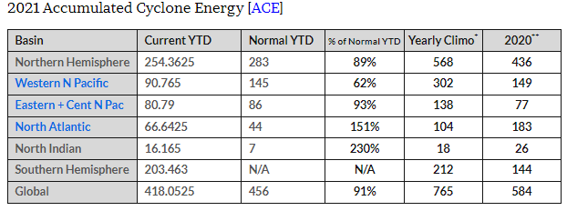
I guess we talking Atlantic ACE? This chart seems to say we're running ahead of normal for 2021, (as did 2020) That right?
I looked at the snow avg calculation and re-did without the highest and lowest (because I feel 1995 is just too anomalous), and still got 20.3" which didn't seem so bad.
-
1 hour ago, Stormfly said:
Like the winter of '77 when people were driving their cars on the ice @the inner harbor! YIKE!

Cold but no snow. YUCK!
Earth's gravity was weaker in those days, so cars weighed less. Actually, I was driving a '68 VW Beetle that winter, (weight < 1800#) so maybe there's some truth there.
I do recall looking at certain wheel tracks on the ice of the WSSC reservoir at the Rte 29 bridge. But I did not drive my car on the ice. I think it was a Chevy Vega. (Don't ask how I know.)
Kids today don't know the fun they're missing.-
 1
1
-
-
3 hours ago, nw baltimore wx said:
5.27” here for August, and your temperature extremes would make me think it wasn’t a bad month at all. But we all know the truth…
BALTIMORE MD...BALTIMORE-WASHINGTON INTERNATIONAL THURGOOD MARSHALL AIRPORT...
THE AVERAGE TEMPERATURE IN AUGUST 2021 WAS WELL ABOVE NORMAL. IT WAS THE 5TH WARMEST AUGUST ON RECORD. IT WAS THE WARMEST AUGUST SINCE 1995, WHEN THE AVERAGE TEMPERATURE WAS 80.1 DEGREES.KNAK (Navy) is my close station, and the same numbers there are 7.34", Lowest 63, Highest 91.
So, living in a woodland, I might miss some rainfall, but I run 2 gauges, and they have agreed within a tenth or so. On the day we hit 59f, I seem to recall that many of our AmWx pals were into the mid 50s. I had 6 90+ days, and KNAK reported 5. KNAK reports avg temp departure of +1.5. BWI claims +3.5. (I don't record this item)
What made it a "bad month" was the very high humidity here. Seemed like every day had a DP around 80 for a couple weeks.
Link for the USNA station August data (hopefullly): https://www.weather.gov/wrh/climate?wfo=lwx
edit: Well, the link doesn't quite take you straight to the August page, (requires more clicks), so I'll try to paste in an image here:
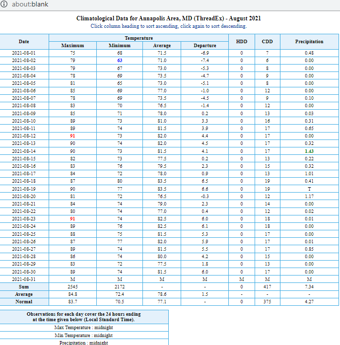
-
August total 4.73"
Lowest temp 59, highest 93.
-
40 minutes ago, WxUSAF said:
Crazy how areas of north NJ that saw so much rain from Henri also were bullseyed from Ida. Got to be some places with over 12” of rain in 2 weeks?
We remember hurricane Agnes in 1972, which became the flood of record for many. But, we forget that it was preceded by other storms which made it a wet May/June. One reason for Pax river flooding was that the WSSC reservoirs were high and lacked storage by the time Agnes hit in June.
Trend, friend, and all that....as they say.
-
1.92" for Sept 1
-
5 minutes ago, nw baltimore wx said:
AACPS never sent out word to its employees. They never closed early. As far as I know, a lot of them were in the building.
Don't know about AACPS, but I was on a video meeting with AACo at the time and they said they had to finish up because they were getting a tornado warning. I believe they're located next door to Dept of Ed.
Was about a little before 2:00pm I think.
eta: Well, the storm would have been at South County a little before reaching the Annapolis/Parole facility, so take that into consideration I guess.
-
 1
1
-
-
5 minutes ago, ThePhotoGuy said:
Lots of trees and wires down in Edgewater.
Leaves drifting down from higher altitude after the rain here in Annapolis. They got sucked up there somehow.
Storm went over us, briefly heavy rain.
eta: got the storm, but I couldn't see any rotation here. (My big weather window faces south)
-
13 minutes ago, chris21 said:
Sun is out just east of DC in Riverdale.
Getting a few patches of blue sky in Annapolis too. For the record; no rain here all day.
-
2 hours ago, mappy said:
.... but a climate scientist on twitter corrected me .....
Hmmmmm.....
-
16 minutes ago, clskinsfan said:
Nice piece of right- place- at- the- right- time- video.
But, that roof seemed to give up easy. Wind noise should have been drowning out the (humorous) audio if it was that strong. Bit strange.
-
Been having a lot of high clouds in Annapolis this morning compared to the 2 past blue sky days.
(I see BWI has been reporting Mostly Cloudy all morning)
If it keeps up, I doubt I'll break yesterday's high of 91
-
12 hours ago, Maestrobjwa said:
What?
Maybe it's a reaction to your negative thought waves. (Or maybe not....I dunno
") )
)
That "deep snow is no longer possible" line comes around every cycle here in Balto. After living through the snowy 1960's, we said it in the 70s...and so on and on....
OTOH, Nature seems to have a way of laughing at the weatherman and suddenly proving him wrong; so carry on I guess.
(No harm meant...I enjoy reading your posts)
-
1
-
-
1.17" today, about 4.65 for August
-
3 hours ago, frd said:
The famous and destrcutive Hurricane of 1938 was moving at an incredible 47 mph. Wow !
... moving at a forward speed of 47 mph!
How was the speed determined before the satellite era? I figure it was by charting observations days or weeks after the storm.
-
Windy rain striking at Annapolis 15:20. Seems a bit ahead of radar image, which shows stronger cell passing just to our east.
We'll see.
-
2 hours ago, Mrs.J said:
@GramaxRefugee yes you can cycle through and get the DP also WC. It is in the temp area. The RH stays just below the temp.
Thank you for checking.
In our climate, I've found that the DP is my most used piece of data. ( I live in a woodland near a swamp, so wind is never an issue, and temp is meaningless without DP)
-
1
-
-
17 hours ago, MN Transplant said:
CoCoRahs requires a particular rain gauge, you aren't supposed to use any of the tipping bucket or other automated gauges. https://www.cocorahs.org/Content.aspx?page=store
I've used one of those 4" gauges since 1980's, and also got a tipping bucket maybe a dozen years ago.
It's fun to do, and you'll notice that both gauges agree at certain times of season; but do not agree at other times. There's nothing to break down on the real gauge, but it does seem to have a secret sign that must say "Bird Outhouse"
-
17 hours ago, Mrs.J said:
I just recently replaced my Davis with this one. Got a recommendation from another member.
So far I like it. I like the three arm instrument set up. I am getting better wind info from this set up than I did from my Vantage Vue. You can look down in my signature and see my Weather Underground web link for it.
Can it be set to read DP instead of %RH (as shown in the link)?
-
This was the most respectable of the 4 storms this week. About 0.85" and rumbling thunder. Couple close CG hits too.
September Discobs 2021
in Mid Atlantic
Posted
(We tease because we love)
IAD was 0.7, which is half of 1.4, so there's that I suppose. And those are the only ones I have readily available. But it just reinforces our idea that BWI is slightly broken, as I think most of us have noticed.