

GramaxRefugee
-
Posts
1,343 -
Joined
-
Last visited
Content Type
Profiles
Blogs
Forums
American Weather
Media Demo
Store
Gallery
Posts posted by GramaxRefugee
-
-
Snow squall here at 16:40; was working outdoors and it caught me by surprise.
-
3 hours ago, Kmlwx said:
I'm torn on whether to root for a last minute freak snowstorm that makes me lose....or if I should just hope for the win at this point.
At this time of year, a heavy snow would be melted in a few days anyway. Winning Glory Never Melts.
However....2.5 inches at RIC, with a little bit at IAD would suit me fine.
-
Feb Total 1.62"
Highest temp 66, lowest 21
-
 1
1
-
-
17 minutes ago, SnowenOutThere said:
If you have any old AFDs from our blizzards saved please do share them as unfortunately I am too young to have been able to read of them live...
Here's the 2016 storm as written by the legendary Paul Kocin. (For some reason it's been hanging around my hard drive for years)
http://www.wpc.ncep.noaa.gov/discussions/hpcdiscussions.php?disc=pmdepd
EXTENDED FORECAST DISCUSSION
NWS WEATHER PREDICTION CENTER COLLEGE PARK MD
1100 AM EST TUE JAN 19 2016VALID 12Z FRI JAN 22 2016 - 12Z TUE JAN 26 2016
HIGHLIGHTS...
LETS CUT TO THE CHASE. THE MAIN EVENT IN THE MEDIUM RANGE IS THE
POTENTIAL FOR A SIGNIFICANT EAST COAST SNOWSTORM FROM FRIDAY
THROUGH SUNDAY/DAYS 3 TO 5. THERE HAS BEEN AND CONTINUES TO BE
RELATIVELY GOOD AGREEMENT ESPECIALLY BETWEEN THE MODEL ENSEMBLES.
COMPARING THE OPERATIONAL RUNS TO THE ENSEMBLE MEANS DOES INDICATE
SOME DIFFERENCES THAT ARE SMALL IN THE LARGE SCALE BUT CRUCIAL TO
THE FORECAST. ALL MODELS SUGGEST THAT MAJOR DEVELOPMENT FOR THIS
SYSTEM WILL OCCUR AS IT MOVES TO THE MID ATLANTIC COAST AND THEN
THE SYSTEM OCCLUDES...BECOMES MORE VERTICAL AND THEN CONTINUES
NORTHEASTWARD WITH THE MOVEMENT OF THE UPPER TROUGH. WITH THAT IN
MIND...THE STORM WILL LIKELY SLOW IN ITS FORWARD MOVEMENT AS IT
MOVES OFF THE MID ATLANTIC COAST AND THEN WILL LIKELY ACCELERATE
NORTHEASTWARD OR ANOTHER TRIPLE POINT LOW MAY DEVELOP FARTHER
NORTH AND EAST. THE 00Z ECMWF SUGGESTS BOTH SCENARIOS. IN EITHER
EVEN...THE OVERALL SPEED OF THE SYSTEM IS IMPORTANT TO AFFECT THE
AMOUNT OF SNOW IN ANY ONE AREA. THIS WILL BE AN IMPORTANT TREND
TO FOLLOW AS THE MORNING MODEL SOLUTIONS START COMING IN.IN ADDITION...ANY TRENDS EITHER NORTH OR SOUTH WILL IMPACT
SNOWFALL AMOUNTS ALONG THE NORTHERN EDGE OF THE HEAVIEST SNOW AS
WELL AS THE ISSUES OF MIXING/CHANGEOVER ALONG THE SOUTHERN EDGE OF
THE SYSTEM. THERE HAVE BEEN SUBTLE NORTH/SOUTH SHIFTS WITH THIS
FORECAST BUT WILL HAVE TO BE ASSESSED WHEN THE MORNING MODELS
ARRIVE. THERE HAVEN'T BEEN LARGE CHANGES WITH THE OVERNIGHT CYCLE.IN GENERAL...THE OPERATIONAL GFS RUNS ARE SLIGHTLY MORE
PROGRESSIVE THAN THE OPERATIONAL ECMWF RUNS. IN PARTICULAR THE 06Z
GFS TRENDED FASTER THAN PREVIOUS RUNS RESULTING IN LOWER SNOWFALL
AMOUNTS DUE TO LOWER SNOWFALL DURATION. THE 00Z UKMET IS SIMILAR
TO THE ECMWF AND TO SOME EXTENT THE GFS BUT THE 00Z CANADIAN WAS
MUCH MORE PROGESSIVE THAN ANY OTHER MODEL AS WELL AS THE CANADIAN
ENSEMBLES. AS A RESULT...LATER IN THE FORECAST...THE NAEFS MEAN
IS FASTER THAN THE GFS MEAN DUE TO THE CONTRIBUTION OF THE
CANADIAN SOLUTIONS. AT THIS TIME...THE HIGHEST PROBABILITIES FOR
THE HEAVIEST SNOW BETWEEN THE ISSUES WITH THE NORTHERN EDGE AND
THE SOUTHERN MIX/CHANGEOVER IS CURRENTLY SUGGESTED TO RUN FROM
NORTHERN VIRGINIA TO EASTERN PENNSYLVANIA/NEW JERSEY INTO SOUTHERN
NEW ENGLAND.TO PUT THIS SYSTEM IN CONTEXT...THE POTENTIAL SNOWFALL
DISTRIBUTION HAS SIMILARITIES TO SEVERAL MAJOR EAST COAST STORMS
IN RECENT PAST INCLUDING THE 5-6 FEBRUARY 2010 SNOWSTORM/THE
JANUARY 1996 BLIZZARD OF 1996 AND THE PRESIDENTS DAY OF FEBRUARY
2003. JANUARY 1996 IS LIKELY TO BE MORE WIDESPREAD/HEAVY BUT ONLY
TIME WILL TELL. THE MECHANISMS COMING TOGETHER FOR A MAJOR
SNOWFALL ARE TEXTBOOK.IN THE WEST...PRECIPITATION SHOULD WANE ALONG THE COAST DAY 3 INTO
DAY 4...WITH THE NEXT MAJOR PRECIPITATION EVENT EXPECTED ACROSS
THE PACIFIC NORTHWEST BY NEXT MONDAY OR TUESDAY...WITH SEVERAL
INCHES OF LIQUID EQUIVALENT EXPECTED.CONFIDENCE...
THIS IS A HIGH CONFIDENCE EVENT THIS FAR OUT IN ADVANCE BUT THAT
ALSO SUGGEST THAT SMALL CHANGES CAN HAVE SIGNIFICANT CHANGES TO
IMPACT. THERE IS STILL 3 TO 4 DAYS FROM THE EVENT AND MANY MODEL
SOLUTIONS TO COME. THERE HAS BEEN EXCELLENT CONTINUITY RELATIVE
TO AVERAGE AND PERHAPS SIMILAR TO WHAT WAS OBSERVED WITH THE
FORECASTS PRIOR TO 5-6 FEBRUARY 2003...WHICH WAS FORECAST AS MUCH
AS 8 DAYS IN ADVANCE. OTHER STORMS HAVE BEEN MUCH LESS
PREDICTABLE. THIS MAY BE ONE CASE WITH A HIGH DEGREE OF
PREDICTABILITY BUT WE SHALL SEE.KOCIN
-
5
-
-
2 hours ago, Jebman said:
Not really sure why visibilities are getting so low on woolly camera at Mammoth. Winds are increasing a lot. That wind is beginning to take on a kind of milkshake froth appearance. Not really understanding what I am seeing here. Okay there is some increase in areal coverage of snow on the woolly lot. It is blowing around a lot more than it did at 3am my time. Winds are gusting to damaging speeds. If snow is actually accumulating, it will be extremely difficult to measure because of 90 mph gusts.
I am not hugging the gfs. This snow is probably only a brief shower or two. This storm is a day late and one hell of a dollar short! We shall see but I am not fooled by the goofus's siren song of 10 to 12 feet. That is pure nonsense. Maybe a foot for Mammoth over the next 10 days including the next storm later next week. I threw that useless gfs out! It's an outlier.
They seem to have measured gusts at 145mph..
https://forecast.weather.gov/product.php?site=rev&issuedby=REV&product=PNS
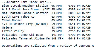
Notice how their gadget drops the highest to the bottom because its not set for 3 digit measurements.
-
1
-
-
low 24
but no frost to scrape
-
0.40" at my gauge; last night's reading
-
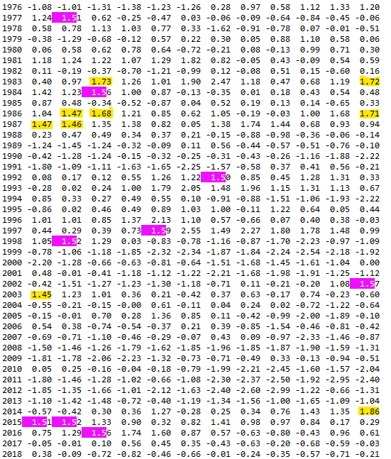
12 hours ago, GaWx said:
For winter:
-2014-5 and 2015-6 were solid +PDOs.
-2016-7 and 2017-8 averaged pretty much neutral
-2018-9 was only modestly -PDO
-Strong to very strong -PDO since
https://www.ncei.noaa.gov/pub/data/cmb/ersst/v5/index/ersst.v5.pdo.dat
I had it highlight the +1.5, and then highlighted anything same or higher. Winter months only. Satellite era only. At first glance it looks like you might expect, but too many exceptions to be definitive.
-
1
-
-
Several rumbles of thunder last evening followed by a shower of 0.01" total.
39f and overcast this morning.
-
On 2/18/2024 at 10:01 PM, RodneyS said:
This article notes that Delaware received nearly 25 inches. https://vlab.noaa.gov/web/nws-heritage/-/unpredictable-the-president-s-day-storm-of-1979#:~:text=By Monday%2C February 19%2C snow,blocked%2C impassable even to snowplows.
What was memorable about that Sunday prior to the storm was the extreme cold -- the temperature ranges were 6 to 15 at DCA and -14 to 8 at IAD.
A link within that link is an analysis of the storm by Uccellini. (Youngsters; he is the U in KU) Pretty good read with updated graphics. Repeating here for convenience:
https://ocean.weather.gov/2-PresidentsDayStormColloquium_Uccellini.pdf
-
4
-
-
Took an involuntary Jebwalk during the storm when my buddy and I stuck his Jeep, (1960 CJ3B; . Badass). Probably about 8am when it was really hitting us hard.
I seem to remember measuring 22" in Howard County, but not certain.
-
1
-
-
Melted down to 3/4 inch now. Will report 1" based on my predawn observation.
33f here
-
2
-
-
23f with frost
(I think about 5 below my LWX forecast)
-
2 hours ago, Maestrobjwa said:
Y'all don't think that...it may have been the volcano? I mean I know some kinda laughed that off, but now I'm starting to wonder. I mean we'd never had that much water vapor, right? So we didn't know the effects...but because it looks so weird, now I'm wondering!
Largest ever recorded by modern scientific instruments. Largest of satellite era. 1000 times the Hiroshima bomb. You are on to something young man.
-
1
-
-
12 minutes ago, Terpeast said:
I’m starting to prefer that. When we lose school days, the kiddo stays home and the only time she’s in a happy mood is when we’re playing outside in the snow. But if we’re not outside, it’s tantrum galore. Rather send her to preschool and keep the snow on weekends when she’s home anyway.
That’ll change when she hits kindergarten or first grade, but for now… yeah.
Just invite a dozen of her preschool friends over to your house. Then she'll be happy and you can have a quiet, relaxing day. Win-win.
(sarc tag, eh...)
-
 1
1
-
-
Annapolis flipped to snow about 8:30. Nice big flakes. Windy too.
-
Temps down from 36/35 after midnight high of 42. No snow yet but some wind gusts.
-
3 hours ago, nj2va said:
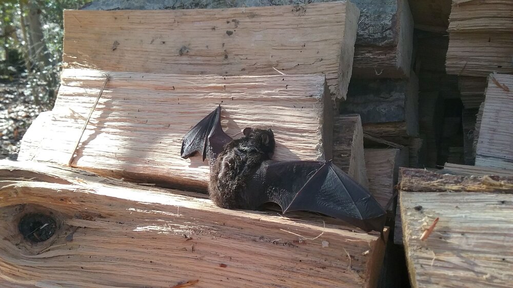
OMG, I would have screamed.
2 hours ago, nw baltimore wx said:No doubt in my mind that my reaction would have awakened that thing from the deepest hibernation.
") Heh, the photo kinda looks like someone left a Halloween decoration on the woodpile. But, the bat was quite docile. It looks like a mouse at first. Then it spread those wings.
Heh, the photo kinda looks like someone left a Halloween decoration on the woodpile. But, the bat was quite docile. It looks like a mouse at first. Then it spread those wings.
I may have to relocate it next week if it doesn't move to a new more sheltered spot. I use my crab tongs for that. (Rabies and all that.)
-
3
-
-
(moved from obs thread)
Uncovered a hibernating bat while loading firewood on Saturday. It was yawning a lot, and I was about done for now, so covered it back up, lest the dog start chasing it.
This is about the 3rd time this has happened, but probably the largest bat.

-
4
-
-
27f this morning.
Been scraping a lot of windshield frost past few days.
Woodstove going early. Cracked open a new pile of 3 year red oak on Saturday and uncovered a hibernating bat. (Suppose I should post a pic)
eta: OK, I put it in the Gardening thread, (but it still reads 2023):
-
2
-
-
4 hours ago, FXW176 said:
There’s a mouse in my house.
I’ve heard it more than seen it, but it definitely exists. I’ve set up box fans to try to blow/keep it away from the kitchen. Doesn’t seem to help. The whopper wrappers in the trashcan are just too much of a powerful mouse magnet.
I might have to move.
The creature is clearly seeking shelter from an impending heavy snowstorm. See if you can trap it or at least get a photo, so we can determine if it's a MECS mouse or a HECS mouse.
-
2
-
-
Just now, snowfan said:
Good radiational cooling night underway. Tipton airport topped out at 50 and is already down to 32.
Same here.
Started this morning from 25 too.
-
1
-
-
Total for January 6.65" (8.5" snow)
Highest temp 75f , lowest 10f.
-
1
-
-
40f and light rain.
Crap weather.


In like a lamb--out like a Lion. March 1958 redux long range thread
in Mid Atlantic
Posted
March 1942 (Baltimore)... Temp anomaly was +2.8...Hit 76f on feast of St. Patrick.....22" of snow fell on 3/29/42. Same date also the lowest temp of the month at 33f. That's right, a 22" snowfall month in which the temp never fell to freezing.