

NittanyWx
-
Posts
758 -
Joined
-
Last visited
Content Type
Profiles
Blogs
Forums
American Weather
Media Demo
Store
Gallery
Posts posted by NittanyWx
-
-
34 minutes ago, LibertyBell said:
Sounds absolutely amazing! The reason I ask is because I'm strongly considering vacationing there next year. Surfing and snorkeling are definitely two things I'd want to do there.
Go, avoid the tourist traps.
Definitely do the sunrise bike ride at the volcano.
-
 1
1
-
-
7 hours ago, ORH_wxman said:
Yeah don’t disagree there. I also don’t disagree that early January never looked brutally cold. To me it sort of looked near normal which is obviously a much colder look than the +5 December temps. But it may end up being more like +3 or something instead of near normal.
We can still snow in that pattern, but it’s harder with a lower margin for error.
Yeah exactly on your last point, which I think was well articulated over the past few weeks. Could snow isn't will snow. And I think the main gripe I'd have if I was rooting for cold/snow is that plenty of folks shared the h5 of the weeklies as a sign for 'massive changes and improvement', yet there'd be no one sharing the t2m, which accurately showed the air being advected via PNA spike was mP due to an extended jet.
Here's what I mean...two weeks back I was asked what I thought about the weeklies at work and I had the h5 charts sent to me and the following: 'seeing on twitter a lot of folks think this is a colder pattern east for New Years...thoughts?'

My response was, did they share the 2m charts? The source region sucks, this isn't gonna deliver anything meaningful/prolonged in early Jan. The 2m charts were pretty damn warm at the time:

Well, here's what we got at h5 surrounding New Years:


I dent think that's a bad job by the weeklies at all. I do think, however, that it was a bad job by certain forecasters ignoring the source region and assuming that the Pac jet would magically ease and cold would just appear. There were plenty on here who disagreed with that premise, but I'd say that was more the minority opinion at the time.
For what it's worth, the EC Ens has also had a cold bias, so risk is this may come in even warmer/closer to Euro weeklies.
As forecasters, there is some element of strategy to what we do and what we communicate. If I see an h5 that's 'better' but I see no source air to advect, I'm not gonna ignore that source air and say 'you know what, the weeklies are way too warm because of h5 and it'll roll forward colder' personally. I'm not saying that to tout my forecast, I'm saying that because I think people got trapped up at h5, whereas some correctly (several in here to their credit) didn't see the mechanism for getting meaningful cold into NA for anything more than a slight step change/transient cool shot that wouldn't last without reinforcing HP and an airmass that wasn't cold to begin with and had no snowcoveras it was advecting into the region.
So, yes, it can snow there, but a lot has to go right. I think the conversation was skewing more towards 'this is a hell of a lot better and split flow is exactly what you want'. The premise being there was longevity to a colder look and this would be normal. My point was the weekly didnt show that, it showed a better h5 but still a very marginal airmass. It's only 'exactly what you want' if you have a source airmass.
Still keeping tabs on Jan 6-7, but outside of that there's not much in this for early Jan on either cold or snow
-
 3
3
-
-
1 hour ago, LibertyBell said:
ever think of vacationing in Bali?
Already went a couple years back. It's a beautiful place and the people are truly special.
Surfed Kuta and Uluwatu, did the temples, spent time with people and got to speak with several regular folks there.
It has a special energy about it. If and when I retire I'm doing 2-3 weeks there with the Mrs.
-
1
-
1
-
-
3 hours ago, snowman19 said:
There is nothing to stop the IO and Maritime Continent MJO phases anymore either…the +IOD is rapidly weakening and should be neutral come mid-January
In terms of sensible weather impact it's already dead. Indonesia is one of my forecast regions.
-
1
-
-
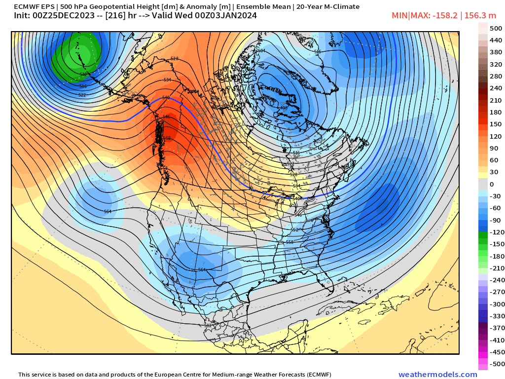
12 minutes ago, ORH_wxman said:
Oh I see what you’re saying…I still don’t 100% agree. We were consistently progged for N or BN heights here and that may not verify…
This is the 5 day mean from the 12/25 weeklies run from 00z 1/2 to 00z 1/7
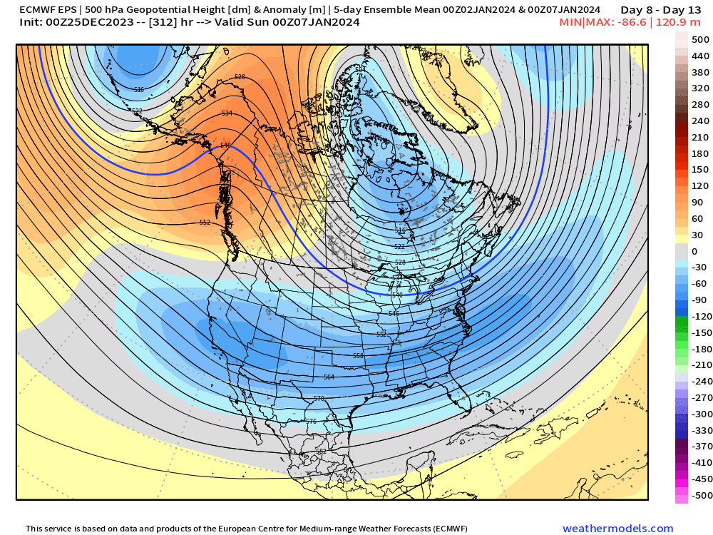
Yeah I'm more looking at it from a week 3/4 prog from the EC weeklies than inside the week 2 frame. I got a few charts I'm gonna share a bit later on today to articulate what I'm saying.
As far as the EC Ens goes, it has had a bias for several weeks of heights and temps being progged too low d 8-15 for most of this winter.
-
1
-
-
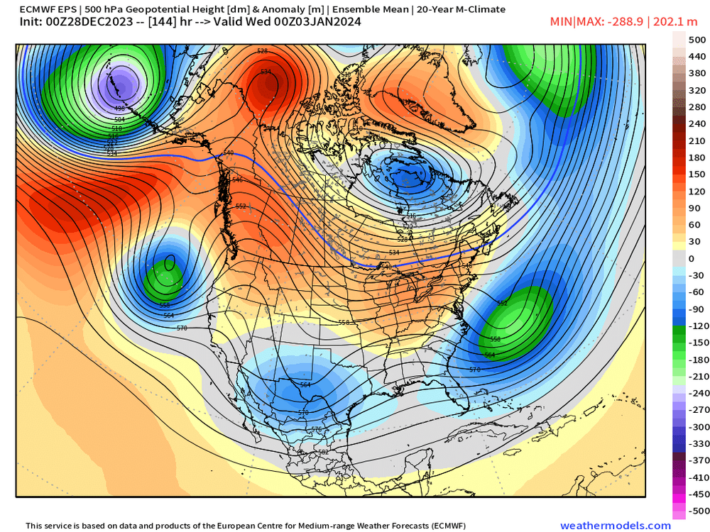
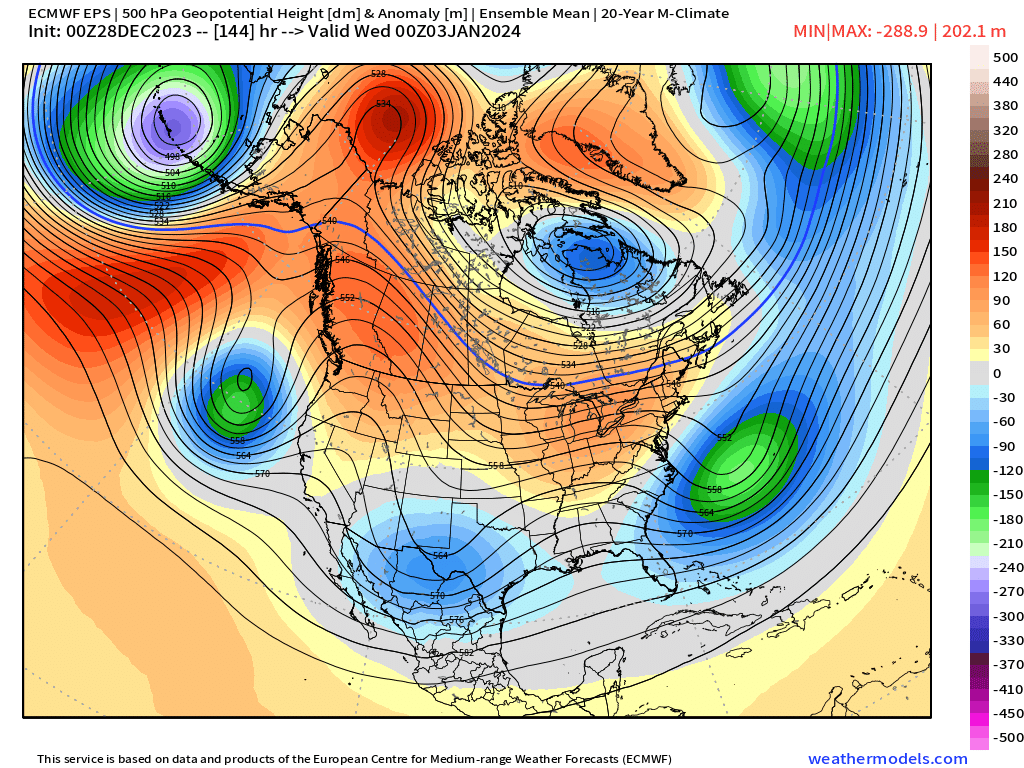
2 minutes ago, ORH_wxman said:
No those are both point forecasts valid 00z 1/3.
You're missing what I'm saying...my post was about weekly h5 view on the EC weeklies for first week of Jan being the basis for a colder early Jan forecast.
A point forecast would be averaged into a week 3 mean...
-
1 minute ago, 40/70 Benchmark said:
I will probably end up too cold in January...my honest guess. But you tell me how this has aged from early November:
January 2024 Outlook
January Analogs: 1958,1964,1966,1973,1978,1983,1987,1988,1992, 2010 (x2), 2015, 2016(x2)This should largely be a tale of two months, as the warmer than average first half should give way to a colder second half that will be accompanied by the first of two historic seasonal snowfall potentials. The first half of the month should focus appreciable snowfall across the interior of southern New England, however, the coastal plane should join with a vengeance. A NESIS caliber storm is likely during the window between approximately January 22 and February 5, however, there is a possibility that it will be focused to the south of New England. The PNA should remain variable, which will continue to fuel an active pattern as the PV grows increasingly more disturbed in the wake of a SSW during the window from about Christmas through January 8.I think you should be feeling good about how this pattern looks at a long lead time.
I'm also not calling anyone out specifically.
-
2 minutes ago, ORH_wxman said:
To be fair, early January on the H5 level looks more hostile than it did even a few days ago…look at the EPS valid 1/3 for the 00z 12/25 run versus last night. That 00z 12/25 run is definitely a colder look than last night…the flow has become more zonal near the Canadian border and the PNA ridge a bit flatter than was being advertised…it’s not a massive change hemispherically, but those subtleties can be the difference between a pretty blah AN boring outcome and a potential snowier/stormier outcome. That 12/25 look has a decent source region for Se Canada…so instead of 850 temp anomalies around -1 for SNE, we get +3
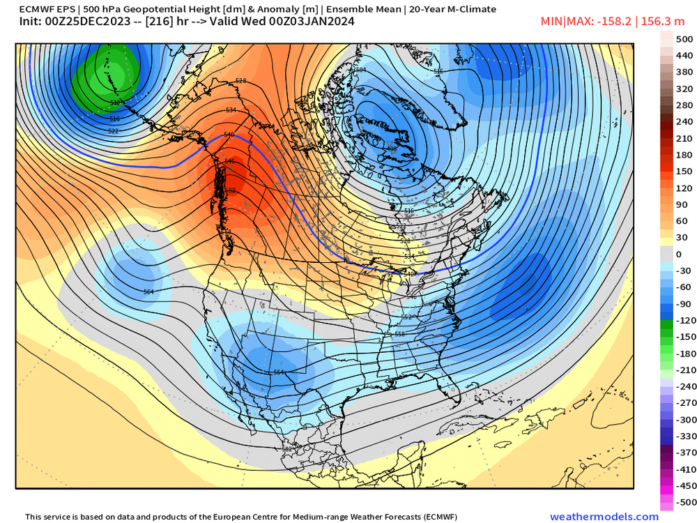
You're comparing a short interval of time to a weekly mean h5 view though.
The source region is and was still garbage.
-
9 minutes ago, Allsnow said:
Agreed. If the weeklies are forecasting this big turnaround because of a SSW then it will most likely be kicked further down the road.
I think you misunderstood what I'm saying.
I'm saying if the weeklies are already seeing it, as a forecaster are you adding any skill on top of it by coming out and saying 'this SSW will dramatically change things'...I'd argue going counter to the weeklies in the dramatically colder direction for example could end up burning you a lot of the time.
-
1
-
-
On 12/26/2023 at 10:30 AM, brooklynwx99 said:
can we get through the first ten days of the month before canceling the entire winter? jesus christ
I can't blame weenies for being frustrated at a lot of early Jan forecasts. It will end up warmer than many were preaching based on the H5 look of the Euro weeklies.
I personally am not canceling winter and haven't seen many do that outside of complaining about mild weather. but this is another case of 'know your source' when viewing h5 forecasts in the week 3-4 range. That said, I think the erosion of mild Pac air is somewhat less hostile than what we're gettng in early Jan
-
5 minutes ago, Allsnow said:
I feel like it gets lots of talk when we are in a mild/snowless winter. It’s usually brought up as one last ditch effort to justify a seasonal outlook or snowy turnaround.
I mean, it can be something that helps turnaround...maybe? It can be relevant to the pattern relative to blocking in the right set of circumstances. But I think the better question is 'are the weeklies already seeing that' in their week 3-5 timelines and further are you doing a better job determining regional temp anomaly distribution than the weeklies are relying heavily on SSW as the basis for your view. Many times the climate models are taking a strato warming event and are assimilating it into those forecasts. So I'm not sure how much forecasting edge you're actually gaining from pointing it out.
-
3
-
-
3 minutes ago, Allsnow said:
The SSW got a ton of tweets by respectable accounts which kind of surprised me
It's something to discuss, but it's also only relevant for Feb...maybe...if it actually happens as progged. There's no issue talking about it, but a lot of people do tend to overhype the correlation to 2m temp, and specifically to 2m temp in the east.
-
3
-
-
5 minutes ago, Stormlover74 said:
Not just this board. Too many of the pros seem to fall into the trap of well it's January it must turn cold and snowy now let me look for any hint of a pattern change and blast it all over social media.
You see a very small sliver of the pro's. Social media pros tend to skew cold because it drives interactions. I don't view Bustardi as an operational met anymore so much as a political pundit hocking books. He has long past his expiration date on reliable forecaster in the long range and a lot of folks have wised up to it. Margavage was in school when I was and flunked out, now returns as the 'cold and snow' guy and gets a following.
There are a lot of good mets around, a lot, who's opinion I value and respect. Some of them were cold 1h Jan, many were not. But they're not gonna be the loudest voice on twitter.
-
6
-
-
39 minutes ago, Typhoon Tip said:
mm Teleconnection spread looked contentious for mid month, though.
We have a -EPO early on, and there's ample suggestion among the operational runs ... materializing cold into the Canadian shield as a result of that. It's gonna set up volatility and potential for time as that happens - no question. But beyond the 5th, the EPO fades and actually flips positive in the index projections from all three ens sources. If the PNA were to stay positive we'd be okay - but the PNA projection beyond that is negative. So a +EPO/-PNA for mid month?
It's a little bit of a head scratch though because the -AO/-NAO phase state is also in the outlooks/agreed upon.
If these grander scaled telecon work out, it's going to be a merry-go-round badly performing operational model run era. I imagine the flow would have to be fast - wtf's new there, huh ... - because the Pac is a warm signal over the downstream continent, whilst the -AO/-NAO is not. So competing larger scale mass-field indicators makes for a mid latitude gradient rich environment with cold over hot.
Seems the last several years ...one f'n way or the other we end up in mid winter with some kind of rage of velocity issues - so how's that for "persistence" ? we'll see
Just personally I care way more about what's happening upstream right now given lack of carpet and atrocious source region. Think the 'way out' of this very mild pattern has to be this +EPO/-PNA combo, which likely means locally it's mild outside of a transient period around the 5-7 and cuts off the Pac flow into NW Canada for a minute. Then when you return to a more +PNA setup given background standing wave pattern you're advecting air that isn't just mild mP that has flooded into NW Canada.
-
1
-
-
14 minutes ago, Dark Star said:
Yes, I do recall. I take it that prog was incorrect, just as the present progs are?
Persistence Forecast: A forecast that the current weather condition will persist and that future weather will be the same as the present. The persistence forecast is often used as a standard of comparison in measuring the degree of skill of forecasts prepared by other methods. The Subtropical Pacific Jet has persisted over the last few years. Despite constant long-range signals for cold periods forecasted during the winter of 2022-23, they never materialized as each one was said “to be delayed”. Presently, the arctic air is not even in the “Western Hemisphere”. Unless this “monster/thing” of a beast in the Pacific subsides or is re-directed, I would not put any credence to any cold weather signals in the near future. (This hypothesis does not necessarily represent the viewpoint of this blogger or of anyone on this site).
You may have found a universally acceptable definition of persistence.
Edit: card carrying member of #TeamWCanFirst
-
1 hour ago, bluewave said:
The first we thing see in early January are the VP anomalies almost going off the scale with the record marine heatwave near 60E. While the MJO composites aren’t a perfect match, my guess is that the shift toward a -PNA week 2 of January is in response to this. A deep trough in the West is close to the MJO 2 El Niño composite. The MJO getting over to 3 would tend to build the ridge again in Canada. But any lingering convection near 60E could hold an undercutting trough in the SW. So we may go to an overlapping composite look for a time before the next step in the MJO becomes better defined.


I suspect you will end up finding progression here in these VP anomalies as well. Particularly as the IOD has collapsed and there's a smoothing of ocean temperature anomalies between WIO and EIO.
-
1
-
 1
1
-
-
1 hour ago, Dark Star said:
Interesting. Originally there was to be no cold dump in the west from Canada, since the first Arctic air was supposed to seep over the pole into north eastern Canada. Has this changed?
This was a fun debate earlier in December.
-
On 12/20/2023 at 3:35 PM, NittanyWx said:
Ongoing source region issue, and will continue to be an issue in early Jan.
Source region remains an inhibitor to anything other than transient early January cool shots surrounded by warmth. Keeping a side eye on the Jan 5-7 window in the event this low amps a bit more, but outside of that 'know your source' remains quite prudent.
Looking bigger picture, seeing signs of the erosion of Pac air upstream into W Canada deeper into Jan. Should be less hostile then.
But as far as this early Jan period goes, the book was written early. A modest h5 improvement, but lack of source air first week.
-
2
-
-
On 12/21/2023 at 5:03 PM, NittanyWx said:
Just a note that the GFS Ens has been posting higher skill scores in the 6-10 at 2m and suspect the EC Ens surface reflections will end up a couple degrees too cold. Sadly even the GFS Op has had less of a cold bias past 3 weeks.
That said, do believe the base state is changing from December. Not a great source region still, but not as dire as late Dec.
The GFS Ens is going to again beat the EC Ens in this post-Christmas period. Both will end up too cold.
-
2
-
-
17 minutes ago, Allsnow said:
Second week looks like a -pna with -nao dumping cold into the west. We very well might get to 1/15 without anything

I think this was well telegraphed personally. In years where you 'got out of it' after a very mild start, this was normally the step change observed.
-
1
-
-
Thoughts today:
The lack of source region remains a barrier to significant cold despite h5 improvements. As such, first 5 days of Jan should average above normal before a transient cooler period 5-7th. Think the risk is cold air overdone by modeling in extended range and HP rolls forward less intense due to lack of snowcover and Pacific air contributing to that issue. Locally, we'd need to thread a needle for a significant snow and you only have a couple windows where I see that as possible early January. As I've said several times now, source is still vitally important. And we are in an improved h5 pattern with marginal source region through the first 7 days of Jan. That's not a death sentence for snow, but margin of error is slim.
First period of interest would be Jan 5-7 range as some HP in Canada and a wave in the southern stream moving northward. I flagged this as a period of potential interest last week and thoughts haven't changed on it. Old adage is 'WAA waits for no man' but this is a situation where if you can avoid a coastal bomb you could get an overrunning situation into NE Canadian high pressure if the cards on the table lay out properly. Several things need to go right, theyre not all 'right' as of today, but that may change.
Big picture, thinking this is a multi step process moving forward whereby the upper level pattern shift will be most notable during the Jan 8-15 window as we scour out some Pac air in North America, TPV retrograde westward (slowly), PNA drops and EPO rises. That should, in theory, start the process of allowing for some carpet to be laid in the Canadian prairies and upper Midwest later in the month. It's not brutally cold, but it's a way to begin to scour some of the much above normal temps in time. It'll be stormy, but mild here I think during that second week of Jan. Could have some much above normal temp days.
Could you see something in that window of transition? Perhaps, but again need several things to go right and big coastals are a no go for snow here in this window. I expect polar regions to be less hostile heading into mid-late month, but the Pac still hostile for the bulk of early Jan.
That brings us to the MLK weekend whereby you're looking for some of this cooler air to potentially migrate S/E ward as PNA rises and board resets towards more traditional Nino with potentially some blocking. Maybe. I think you've got a lot more reasons to be optimistic after MLK than before, with the caveat that you'd hope the Pac jet isn't as hostile as it has been if you're a snow lover.
As an aside, I'm not considering any potential Strato interaction on this pattern until perhaps February, if at all. I just view any potential 'help' there as supportive of blocking and not necessarily supporting a Pac change.
-
5
-
4
-
-
3 hours ago, MJO812 said:
All the meteorologists on Twitter including the good ones are forecasting it.
MJO shouldn't be weenied for this one. He's right that most are calling for a warming event and potential split. It does look valid and will qualify as an SSW event in all likelihood.
What will be overhyped is the correlation between SSW and t2m in the east. SSW events are essentially a correlation of a correlation to 2m temps. SSW inducrd PV displacement and splits are correlated to periods of more blocking which is correlated to colder temps in the mid latitudes of varying intensity and regionally/unevenly distributed.
That correlation to temperatures is mostly 3-4 weeks after event. So this would in theory increase colder odds for the mid latitudes in February. But that doesn't necessarily mean colder in the northeast. It might, but it's not guaranteed.
Historically splits work better for NA in analogs....but theres a huge caveat that the pac jet will need to relax and the EPO will need to be way less positive that it is right now.
In short, its a situation where one of the factors we track in the weather becomes less hostile in theory to cold in the mid-latitudes. That said, we don't live at 10-50mb level, so it's one piece of a large puzzle.
-
3
-
2
-
-
45 minutes ago, NEG NAO said:
12Z GFS OP - shows the 1st storm passing by mid week then the upper low and more energy is left behind with not enough cold air to support frozen except in the Apps by late 12/29 early 12/30 a 993 LP off the south jersey coast - something to watch to see if colder air is somehow drawn into this system in future runs

12Z CMC shows similar system

Not enough cold air to tap into
-
4
-
2
-
-
13 hours ago, MJO812 said:
Yes this far out but you have to be excited ( yes I know it's far out ) how this pattern is evolving . Compare this time last year to this year. Way different.
I think we have different definitions of excited
-
1
-


January 2024 -- Discussion
in New England
Posted
I think the giveaway was threefold on how bad the source region is/was:
1) Snowcover, or in this case the complete lack thereof
2) Lack of appreciably anomalous HP upstream
And
3) +25s in the front weeks for N/NW Canada preceding this h5 change. While I don't disagree you generally will get better performance at h5, I think this was a situation where the forecasters had enough in front of them to say 'you know, I don't like the source despite the h5, I'm not gonna paint this significantly colder than the model because I don't see a mechanism where I can tap into anything'..
The play was to reduce the much much above for a small period and get closer to normal. But I think by mid-Dec you had a lot of reasons to question whether even normal is valid.