

NittanyWx
-
Posts
758 -
Joined
-
Last visited
Content Type
Profiles
Blogs
Forums
American Weather
Media Demo
Store
Gallery
Posts posted by NittanyWx
-
-
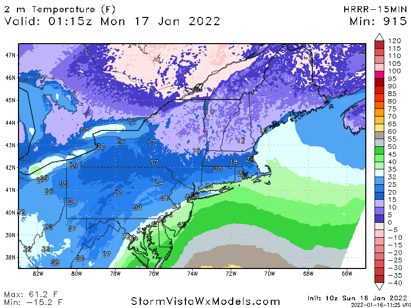
Using 12-1 ratios because the wind is gonna beat up these dendrites. 10+ island and much of coastal NJ and coastal CT seems fair. It's that sharp gradient keeping me up right now. I'd love this to tuck 20 miles further west just to make this a bit more straightforward
-
 4
4
-
-
13 hours ago, NJwx85 said:
Snowed moderately at my location in SE Rockland County from 8pm to 1am. Finished with about 3” before the changeover. It thumped for a good 3 hours.
So not the 12 hours of snow 15 miles inland then?
-
 1
1
-
-
7 minutes ago, Wxoutlooksblog said:
I do not agree with this. It is one run cycle during which every model is somewhat flatter/further south and east and the ECMWF is only very slightly further south and east & importantly to note, slower. That slowness continues the threat into Sunday with some question marks. One is timing. There are numerous impulses of energy s/w's into the southern stream which could develop. Which one is it going to be or will it be consolidated into one? The European IMO keeps this threat in play maybe another 12 hours later. The Euro is not bad. It holds serve.
WX/PT
Most of the downstream changes are a knock on effect of subtle differences occurring inside hour 72 with regard to that northern stream piece. It's becoming a bit less theoretical today. Still some time for it to change again, but inside 72 you tend to look at it as a bit less theoretical vs trend tracking.
-
4
-
-
44 minutes ago, snywx said:
This event was 99% frozen here.
Barely above freezing now..
32.4f
That shift in warm nose at 925/850 made a huge difference up there. Nice job by Albany on seeing that early yday.
-
24 minutes ago, HVSnowLover said:
How much qpf did it have at this time? Temps look accurate but seems the precip came in a little earlier.
Precip timing was fine at the 10z cycle, it has 0.1LE a little after 9 in the city and S Westchester closer to 10. So pending SWE it could end up a bit too dry if anything.
But as far as temperatures go and the coastal front, that was handled well.
-
20 minutes ago, binbisso said:
It did have its starting as snow for the 1st hour less than .1LE So it didn't show on the clown maps. However the 23Z shows .15LE falling as snow. I started snowing here at 6:30 still snowing moderately now a little over a 1/2 inch so far probably gonna end up with 1 to 2". Most models had me with nada including the uk GFS RGEM, gem and regular nam.
You were repsonding to a post of mine talking about the performance of the model with the coastal front. From there went on about how the 21Z HRRR 'showed no snow', which is just flat out wrong. It also kept Ptype as snow through 9pm, or roughly 2 hours.
LE may end up around 0.1", which is where the 21Z HRRR may end up underperforming. If you would have said that, I would have agreed with you...
-
2 minutes ago, HVSnowLover said:
I think its ok to acknowledge this was a little colder than modeled? I think everyone realizes this is mostly going as scheduled.
Depends on which model. Here's what the HRRR had this morning for right now:
I'm a big stickler on revisionist history in this field and will call it out every time.
-
1
-
-
For the record, the HRRR has been showing this starting off as snow pretty much all afternoon...
Use the clown maps at your own risk. But it's straight up false to say it didn't have this starting off as snow for an ay least an hour via the 21z run.
29/25.5 in Wilton, light snow.
-
1 minute ago, binbisso said:

Do I need to say the clown map thing again?
-
1
-
-
7 minutes ago, binbisso said:
The 21z hrrr had 0 snow for me in so westchester. Newest run 1.5". It's starting to get a hint
What are you talking about?
-
1
-
-
6 minutes ago, lee59 said:
I just saw a report from Seaford long Island only about 4 miles to my southeast that it is raining. I just looked at temps in the region and south of Hempstead Tpk. route 24, temperatures are in the mid to upper 30s and apparently raining, north of the turnpike it is the low 30s and snowing.
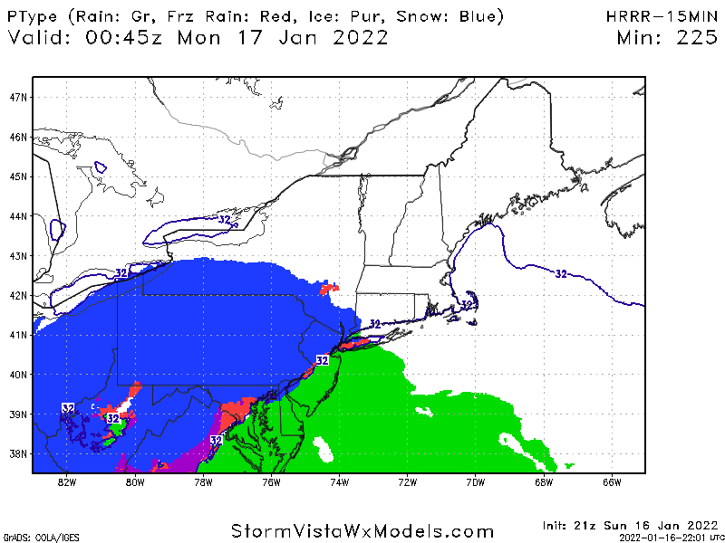
That gradient won't last very long. The HRRR has been pretty good at modeling this coastal front
-
Would very much appreciate peak wind gusts in the AM for those of you with a PWS.
-
1
-
-
95% of the metro area looks in line to be above freezing by 11:30. Orange County and maybe the hills of Sussex the exception. Storm behaving as expected.
-
3
-
-
Looking at some upper 20s and 30 degree readings into lower Manhattan.
-
27 minutes ago, HVSnowLover said:
I agree about mid levels maybe but low level cold is definitely stronger already than what the models have been showing.
The HRRR has been fine.
-
Winds have shifted to an easterly direction in Fairfield County, CT and temps have quickly jumped to the mid 20s.
It will only take a subtle wind direction shift to warm things up considerably.
-
12 minutes ago, nycsnow said:
Latest nam has nyc east gusting 40-50 by 10pm with a max of 70-80 during early Monday morning hours. Wild
I was surprised Upton kept the HWW limited to eastern areas, I think most of the Island will verify criteria.
-
2
-
-
Still expecting the inversion to hold for most north of the Island. I'm a bit surprised Upton hasn't extended HWW further west as of this morning. Think odds are pretty high of that verifying south shore and much of the Island at large.
-
4
-
-
13 minutes ago, MJO812 said:
So you are going with an op run that's definitely going to change instead of a well thought post by a meteorologist?
Now you know how I feel.
-
3
-
 2
2
-
-
47 minutes ago, IrishRob17 said:
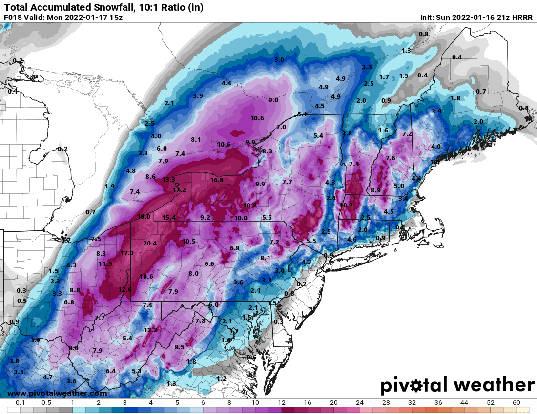
And take a look at the snow accumulation map from that run…

I dk how many times this week I said that wasn't gonna be snow...
-
5
-
2
-
-
2 minutes ago, jm1220 said:
Inland that can work. Here as soon as the SE wind starts that hope dies.
*Far* Inland.
Would need a major (and it should be said quite unlikely) error with the northern stream to have much impact around the major cities like he's suggesting.
-
I dont want to speak for the guys at Mt. Holly or OKX, but I think they're waiting to see the northern stream piece sampled by our upper air network first given its importance to how far inland the low tracks. That's the only thing I can think of at this point.
-
9
-
-
35 minutes ago, USCG RS said:
Sounds like they need a good Emergency Manager....
They need to be broken up and sold for parts. As does PURA up here in CT.
-
2
-
-
10 minutes ago, sussexcountyobs said:
JCP&L is never ready. They're the worst.
I'll raise you one with Eversource up here in Connecticut.
-
2
-
1
-

January 28-30th Possible Nor'easter
in New York City Metro
Posted
Same issue with the dendrites getting beat up. Perhaps even more so. You'll just have way more liquid to work with.