smokeybandit
-
Posts
4,162 -
Joined
-
Last visited
Content Type
Profiles
Blogs
Forums
American Weather
Media Demo
Store
Gallery
Everything posted by smokeybandit
-
Finally got a solid storm (and hail that was appreciably small) today. My yard was due after all the storms spinning up all around me the last week or so.
-
Some impressive hail and localized rain Denver and metro south and east. But a nice cell that was headed my direction dried up before it got to me.
-
I swear I have a force field around my house. I just had rain and thunderstorm activity within 3 miles to my north, south, east and west. And didn't get any measurable rain.
-
I picked up about an inch this week. I wish it was more, but my lawn is finally starting to show signs of life.
-
Snow mixing in with rain at 6300 feet.
-
Looks like this storm is further north than projected. Models drying up south and east of Denver. But look like a heck of a snowstorm in Wyoming
-
I largely missed out on today's rains with the bulk of it passing to my east. Hopefully something substantial tomorrow.
-
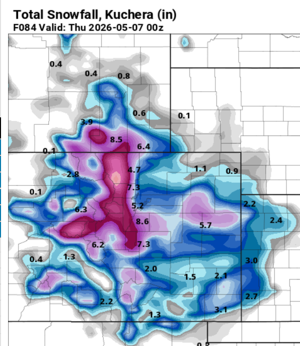
18z NAM has the snow bullseye over...DIA?
-
GFS has backed off a lot, but still has a few inches for the Palmer Divide and foothills. NAM also has it. Waiting for the 12z Euros to kick off.
-
Seems like a rain event with maybe some cutover to snow briefly in some lower elevation places.
-
All my snow was gone by midday. It's Colorado so you never know, but, that appears to be the end of any snow chance for the season.
-
Most of mine melted already. For sunny spots that still have snow, probably only 2-3" left.
-
The only problem with May snow is that for most of us it'll all largely be gone tomorrow
-
Looks like I'll pull an extra inch from this morning's stuff. So 8" Even with that, still has me under 50% of normal for the season.
-
Some excellent moisture for the area, especially the mountains. Hopefully that keeps the edge off fire season.
-
Almost 7" accumulated, but only 3" overnight, which was supposed to be the bulk of the storm. We'll see what this last wave brings this morning, if anything.
-
Some flakes mixing with rain here, temps up to 36. But the forecast really doesn't have any accumulation until the front passes late tonight. So no rational fears of a bust here, just the typical irrational ones.
-
12z NAM brought a lot of the snow back to the Palmer Divide, so maybe it just didn't have coffee at 6z. 34 degrees here, several degrees below what was forecast for this time of day.
-
06z NAM started slashing snow totals. We'll see if the others do so at 12z.
-
Well we're 24 hours out and local mets are increasing their snow amounts. Right on schedule for waking up tomorrow with the totals halved.
-
I'm already pre-pissed so when it happens I'm not as disappointed.
-
-
18z NAM even bigger than 12z
-
Euro is now generally on board, too, though its snow maps look kind of goofy around the Palmer Divide
-
12z NAM says let's do this. Even the Euro is now showing a few inches for the Front Range.