AccuChris
-
Posts
737 -
Joined
-
Last visited
Content Type
Profiles
Blogs
Forums
American Weather
Media Demo
Store
Gallery
Everything posted by AccuChris
-
Temp has now dipped below freezing with a mix of snow and sleet in Lebanon. Roads getting covered .
-
Just a coating in Lebanon. Temp down to 33° .
-
Yes, it was a tick more southeast though obviously not as suppressed as the Euro was .
-
18z GFS also still bullish for middle of next week .
-
Central PA Autumn 2024
AccuChris replied to Itstrainingtime's topic in Upstate New York/Pennsylvania
Currently a mix of sleet/snow in this passing shower in Lebanom . -
Central PA Autumn 2024
AccuChris replied to Itstrainingtime's topic in Upstate New York/Pennsylvania
Rain tapering off quickly in Lebanon. .89” in the gauge….temp 41° . -
Central PA Autumn 2024
AccuChris replied to Itstrainingtime's topic in Upstate New York/Pennsylvania
Rainfall total .21” in Lebanon . -
Central PA Autumn 2024
AccuChris replied to Itstrainingtime's topic in Upstate New York/Pennsylvania
The 12z Euro, even though doesnt show a lot of snow, does show absolute brutal cold in the extended period . -
Central PA Autumn 2024
AccuChris replied to Itstrainingtime's topic in Upstate New York/Pennsylvania
Moderate snow falling in Lebanon. Temp at 33 . -
Central PA Autumn 2024
AccuChris replied to Itstrainingtime's topic in Upstate New York/Pennsylvania
18z GFS Thanksgiving storm . -
Central PA Autumn 2024
AccuChris replied to Itstrainingtime's topic in Upstate New York/Pennsylvania
Finished with 1.01” in Lebanon with this first part . -
Central PA Autumn 2024
AccuChris replied to Itstrainingtime's topic in Upstate New York/Pennsylvania
18z long range HRRR still very bullish on snowfall . -
Central PA Autumn 2024
AccuChris replied to Itstrainingtime's topic in Upstate New York/Pennsylvania
12z Euro Kuchera is on steroids through the period [emoji15] . -
Central PA Autumn 2024
AccuChris replied to Itstrainingtime's topic in Upstate New York/Pennsylvania
12z NAM holding with the general snow theme . -
Central PA Autumn 2024
AccuChris replied to Itstrainingtime's topic in Upstate New York/Pennsylvania
Latest long range HRRR looking fun and still cranking at hour 48 . -
Central PA Autumn 2024
AccuChris replied to Itstrainingtime's topic in Upstate New York/Pennsylvania
12z NAM kuchera snow map…event still ongoing at hour 84 . -
Central PA Autumn 2024
AccuChris replied to Itstrainingtime's topic in Upstate New York/Pennsylvania
12z GFS still indicating a pattern change to more wintry weather starting this Thursday through the rest of the 2 week period. Kuchera snow map because why not . -
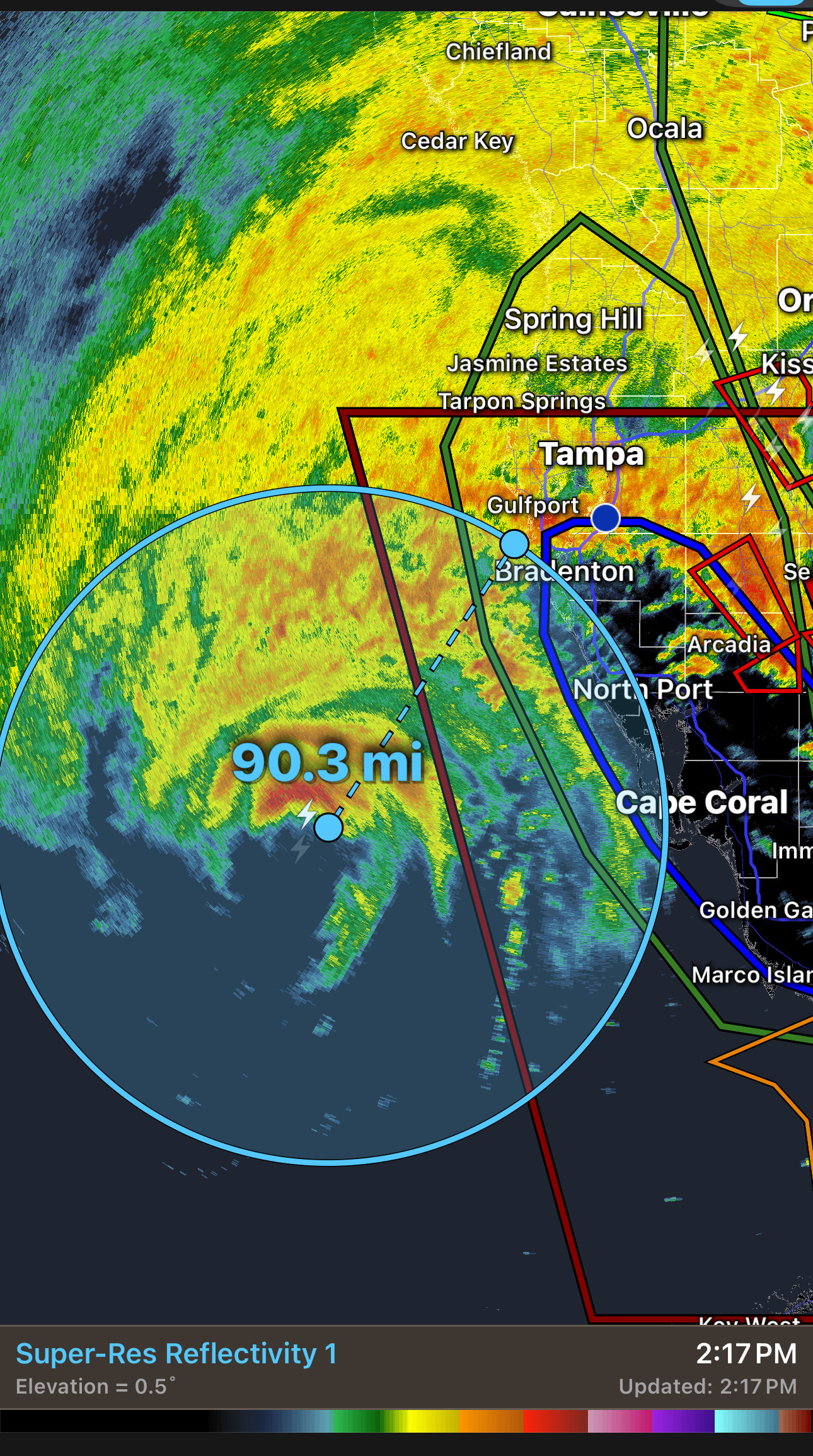
Purely extrapolating current heading and distance it still looks on pace to landfall pretty darn close to Anna Marie Island in about 6 hours…barring any wobbles .

-
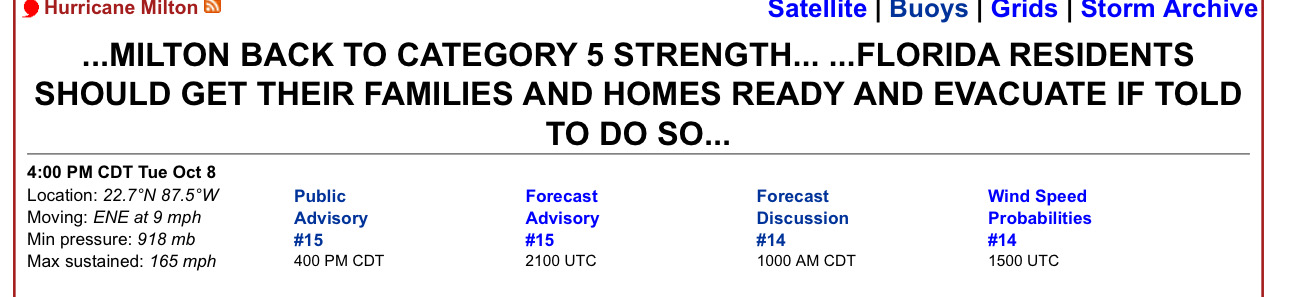
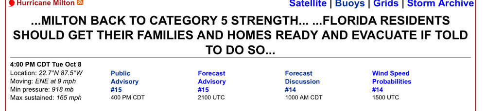
The graphic was not updated to show their latest pass but as someone else just noted, looks like the plane missed the eye by 8-10 miles so that pressure of 941mb was not a true accurate SLP reading in the eye .
-
I was wondering the same as the lowest pressure they found was 941mb. So either they totally missed it or the pressure rose 20mb in an hour .
-
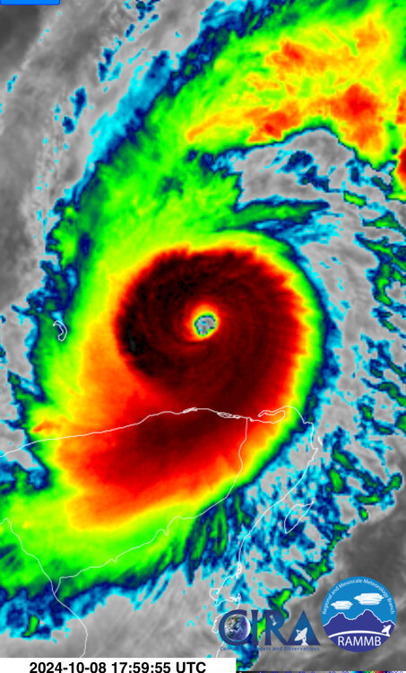
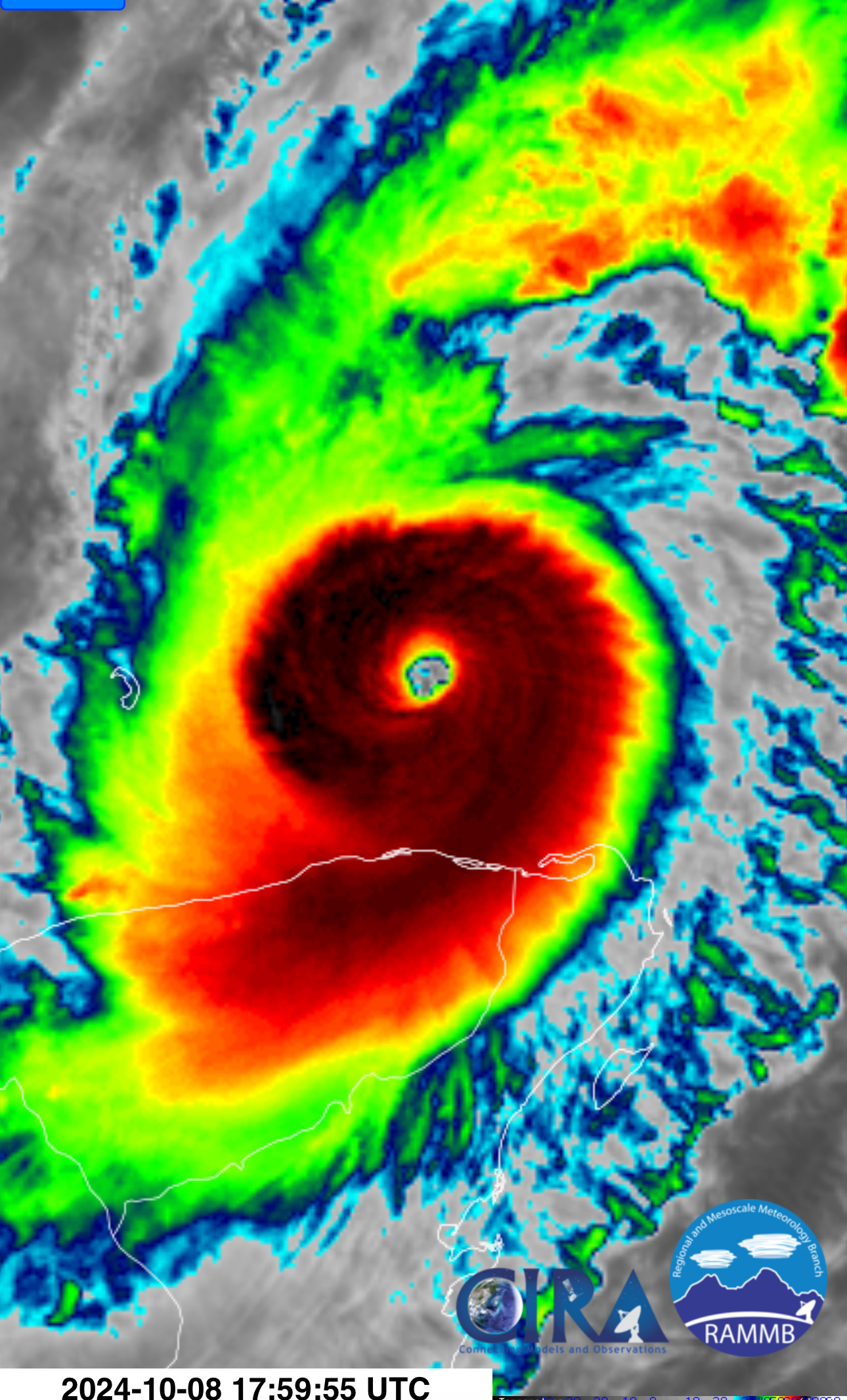
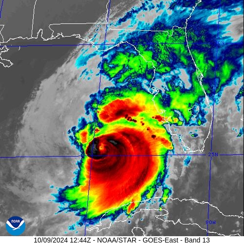
Latest IR shows deep convection really starting to encircle the eye wall again. Will be very curious to see how it responds to a more hostile environment but would no be surprised to see the eye re-appear in the next couple hours .
-
I imagine NHC will be doing a special advisory update increasing the winds and updating for the lower pressure in the near term .
-
Back to Cat 5 .
-
Latest recon just getting into the storm so we should get some up to the minute data on Milton over the next 15-30 mins .
-
Absolutely looking textbook again .