

TradeWinds
-
Posts
527 -
Joined
-
Last visited
Content Type
Profiles
Blogs
Forums
American Weather
Media Demo
Store
Gallery
Posts posted by TradeWinds
-
-
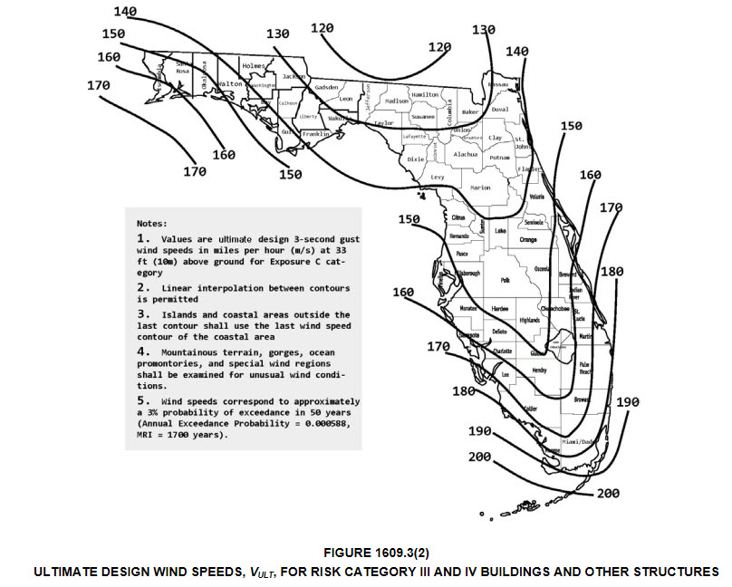
I'm surprised Taylor County building codes are only to withstand 130 mph gusts let alone sustained winds. I'm sure many are built above standards but older homes will be tested.
-
21 minutes ago, Windspeed said:
Wind interacts differently inland for a TC versus over the water or right at the coast. You get gusting bursts due to friction and turbulence. 100+ mph gusts are definitely possible if that is where the core traverses.
Speed is what might make the difference. I know when Hurricane Charley zipped across FL, Orlando had its highest gust ever at 108 amd that was pretty far from landfall. What surprised me is FL building codes are only to 130ish where this may landfall. I would think Valdosta older buildings/roofs could see high damage if hurricane force winds are sustained.
-
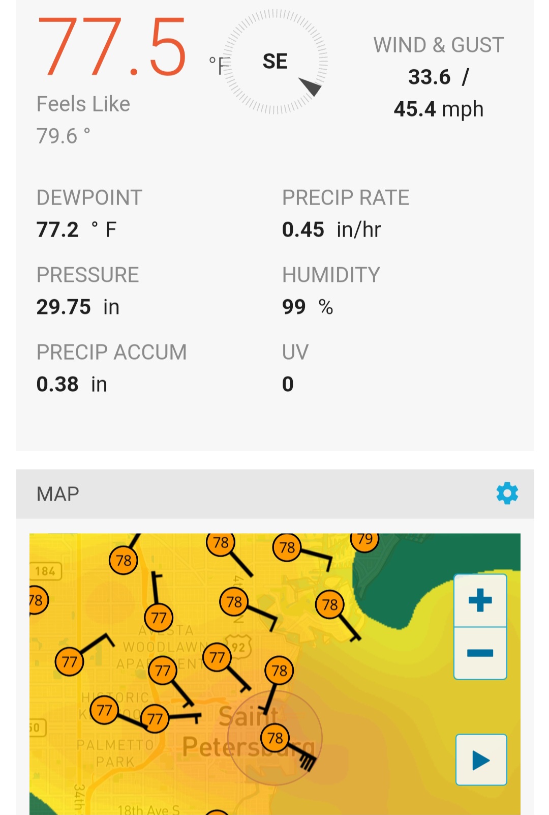
Was looking at some obs in the band over St Pete. Not bad. Almost tropical storm force winds.

-
 1
1
-
-
13 minutes ago, cptcatz said:
GFS for the most part was the outlier for Ian. Lots of other models had it going between Tampa and Ft Myers. All the models are in agreement with Idalia.
Don't disagree on current consensus but GFS was not the outlier for Ian. UK and Euro were mostly the outliers.
-
6 minutes ago, Hotair said:
There’s lots of chatter now that latest models have shifted LF guidance about 30 miles West. But didn’t these runs initialize with a 20 to 30 mile westerly offset ?
Looks like tighter clusters mostly but many of the more western tracks show the cane moving NNW starting now or even should have by now. Time will tell.
-
1
-
-
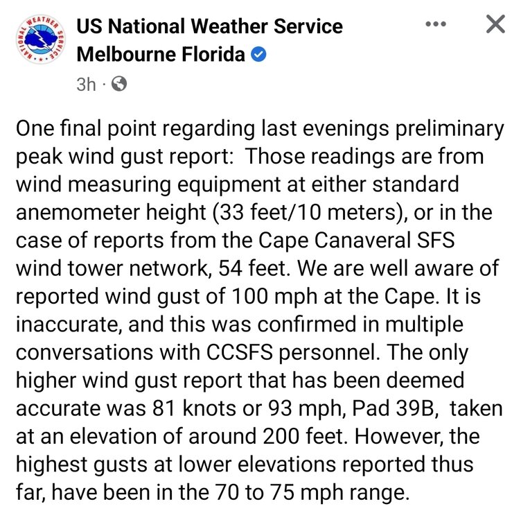
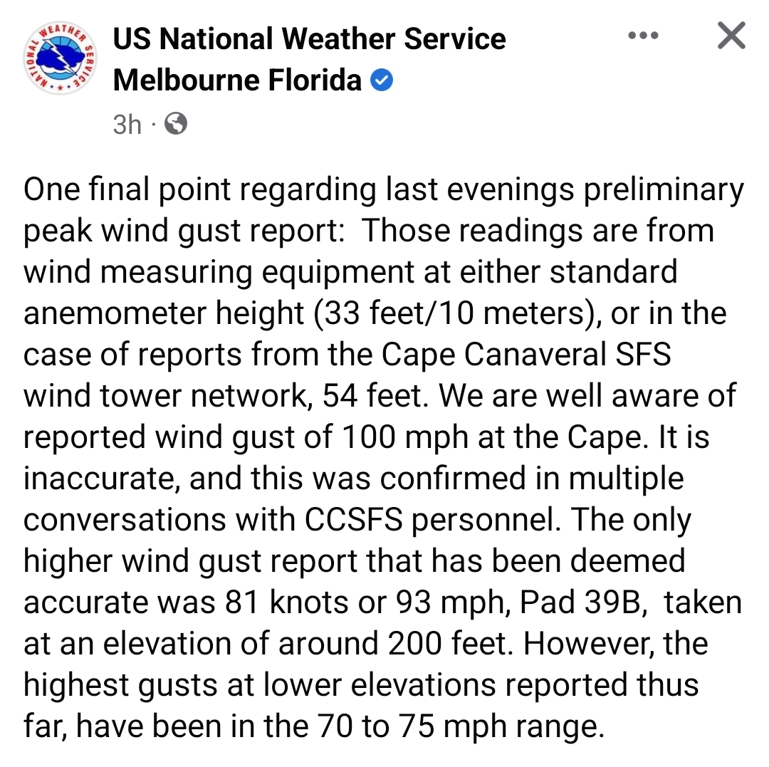
Some clarification from NWS Melbourne
-
1 hour ago, Normandy said:
This doesn't make any sense. Having 100 MPH flight level winds does not make a storm a hurricane. The lack of sustained 60+ MPH winds anywhere near the coast suggests this did not have 75 MPH sustained surface winds. It is possible for a storm to be stronger aloft and weaker at the surface. It is also possible for a storm to have weaker flight level winds and have the winds mix down better. Nothing I am saying here downplays Nicole as a storm.
What you describe is true of every tropical storm. Very rarely do rated winds verify, at least consistently.
-
2
-
-
4 hours ago, Rockem_sockem_connection said:
quiet around here but that's good since if no one is interested in talking the storm must not have killed anyone or damaged much
At least 2 people died in Orlando related to electrocution of a fallen power line.
-
3 hours ago, GaWx said:
By looking at the county by county power outage map, one can get a good idea of where the highest winds were. In FL going up the coast, significant numbers of outages don't start til Indian River county, where Nicole made landfall. The next county up, Brevard, has by far the highest number and percentage in the state with 25% out (as mentioned above). Significant outages go as far north as St. John's (8%) in NE FL. Even way up here in SAV, my power was out for a couple of hours and just came back on.
In stark contrast, SE FL (which was on the weak side of the eye) has only a very low % out (under 2% St. Lucie county southward).
Although well inland, Orange county (Orlando) has 6% out and Marion county has 9% out. In NW FL, Madison county at 19% has the second highest percentage out! Does anyone know why?
Overall, for a minimal hurricane, Nicole has been pretty impactful on the strong side of the eye. I'm pretty sure that most minimal hurricanes haven't had this much impact overall. This was aided by a strong gradient due to the big high that was to the north.
Orange County looked to peak at several hours of sustained TS (35-38 mph) with gusts to mid 50s. I heard transformers popping this morning.
-
 1
1
-
-
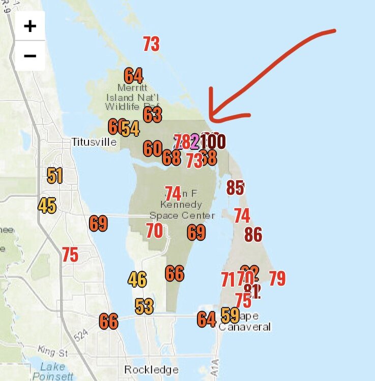
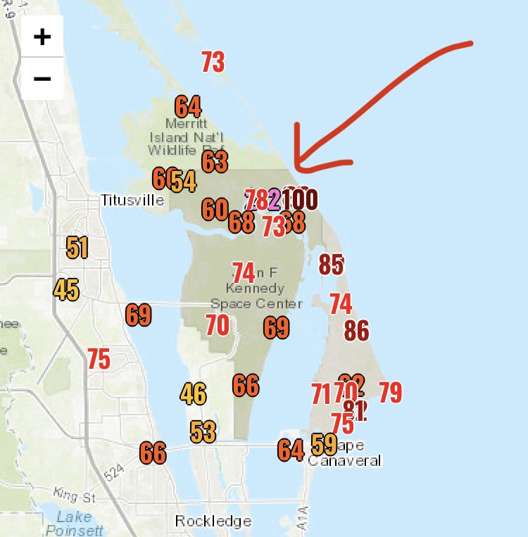
30 minutes ago, Intensewind002 said:
Were there any reports of hurricane force sustained winds on land? I'm assuming probably not. What about gusts 75+ kts?
Here are some reported gusts. I believe cocoa had several 70+ mph gusts. The 100 was at 120 ft elevation as has been reported.
-
1
-
-
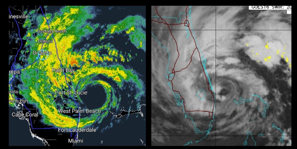
A little close off and tightening just before landfall. Impressive for mid Nov.
-
15 minutes ago, WEATHER53 said:
What year did it break?
1935 - Miami (Nov 4)
1985 - Kate (Cat 2 into Panhandle Nov 21)
-
42 minutes ago, Amped said:
One of the ugliest looking Hurricanes you'll see make landfall. But I guess it's November so What'd you expect.
Quite impressive actually for the latest FL east coast landfall in recorded history.
-
3
-
-
6 minutes ago, dbullsfan said:
Question for everyone and forgive me if this should be in the banter thread, but. When I look at the radar on weather.com it looks like the eye is almost going NNW as it lands putting it on a track to go over Orlando or even east of Orlando. This seems to differ from the cone or most tracks, is this just the model they are using or are they projecting a jump east in the track? Or am I just misreading the radar
.It's like an optical illusion especially with wider eyes. They also use a composite radar I suppose. Even on radarscope, you can tell on a 20 frame loop it is WNW. Check out this loop and you'll see jogs but a general WNW.
https://twitter.com/TMainolfiWESH/status/1590518516167368704?t=enBwT-KL08LxbScN89GQ9w&s=19
-
1
-
-
Interesting official forecast for Orlando just increased wind forecast at 7:30 PM update to peak 55-65 with gusts to 80. Don't see that verifying but we'll know more as reports start further south.
-
A doorbell video from Abaco. Looks like what you would expect from a TS.
https://twitter.com/NashWX/status/1590433968822026240?t=OTtGHJ03ch35aw3Ipsr-fQ&s=19
-
2
-
-
A storm pic from Coopers Town as Nicole passed.
https://twitter.com/Tribune242/status/1590431132113580032?t=IjG5Oh36pRIpJn_xnRaCiQ&s=19
-
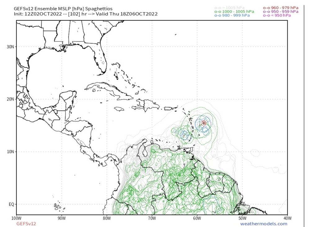
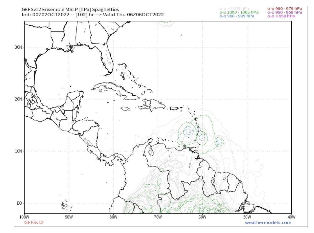
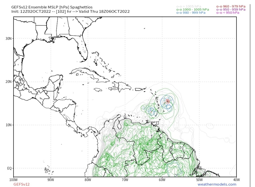
GEFS now showing some earlier development compared to 24 hrs ago.

-
1
-
-
5 hours ago, Jersey Andrew said:
Sadly agree with you. Good friends of mine barely escaped from Fort Myers Beach with their lives. Other friends and family are shaken. Look how Florida handled the Surfside condo collapse. Just pay off victims and families of the deceased so we can move on with business as usual. Have to keep the tourism merry go round going to fund the state.
People also choose to build and live in hurricane prone areas, just as they choose to live in tornado alley or on a fault line. People also choose to evacuate or not. Ft Myers was in the cone the entire time. I'm sorry for their loss but personal decisions are real.
-
1
-
-
1 minute ago, Akeem the African Dream said:
Ukmet killed it
one of the weather observers in the sesh was going on about how it is a shit model and he never looks at it
Yes, a lot of people embarrassed themselves here. Also a shout out to the people that kept sharing the tweet about how well the GFS did. Our local met in Orlando actually lol'd last night when he mentioned the GFS.
-
 1
1
-
-
2 hours ago, Clyde said:
East of Orlando here, yard flooded, water 6 inches to a foot deep everywhere, septic backed up. I don’t live in a flood zone so can’t imagine what it looks like in those places. We got 11 inches of rain with Irma and had no standing water so this is quite something. Oh, no wind damage to note and didn’t lose power which is a minor miracle since I typically do for pretty much anything stronger than a deer fart.
.Orlando got hit hard. I received 14.13", almost 6" just in that band last night between midnight and 3 AM. Had to help neighbors as water entered their homes. The flooding in Orlando is ridiculous. We are now pushing 12 hours of tropical storm force winds and gusts to 60. Ian was a beast in FL.
-
2
-
1
-
-
Absolutely ripping in southern part of Orange County near MCO.
-
2
-
-
Our local mets explained why Orlando to Daytona is experiencing some of the highest winds this evening. Daytona had a 73 mph gust. The cold front is causing an intrusion of cold air. As the cold air sinks, it is efficient at bringing down the winds aloft. The rain is helping too.
-
1
-
1
-
-
This convergence zone over Orlando is producing high rain rates and wind. MCO last hour is 37 sustained and 60+ gusts. I'm seeing lightning and hearing thunder.
-
4
-

Hurricane Idalia
in Tropical Headquarters
Posted
I think Orlando would disagree with that, unless you're talking homes demolished.