

Picard
-
Posts
177 -
Joined
-
Last visited
Content Type
Profiles
Blogs
Forums
American Weather
Media Demo
Store
Gallery
Posts posted by Picard
-
-
Up to 2.27" on the day. Pouring again. I'm going into hour 7 of observable thunder and lightening.
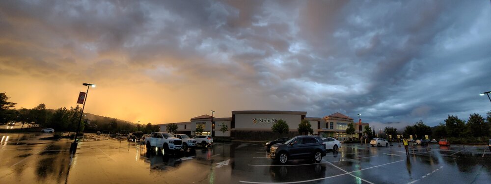
I took this photo earlier from the Stop and Shop in Sparta of brightening skies off to the west and ominous storm clouds overhead and to the east. The image is very true to how it actually looked and it was taken around 8:10 PM. The storms won the battle again a short time later.
-
 2
2
-
-
I'm up to 1.46" on the day. Surprised it's not more, but I'd rather get it pieces, and not 7" at once.
The line just keeps re-loading to my south. I've now observed constant thunder and lightening for the past four hours.
-
2
-
-
In a deluge here. 0.44 here just in the last 20 minutes or so. Looks like the storms are training over the area now which could lead to some serious totals if you stay under that red.
-
Mom says no power and no phones. Two large branches are down in the yard. I'm heading out that way shortly. 1.4" of rain from the storm - and 0.00 here five miles away.
-
1
-
 1
1
-
-
Any severe reports/damage out of Sussex County?
That was a nasty cell. It skipped just to my north and looked ominous. My 75 year old Mom is texting me telling me it was scary up her way with wind and her neighbors lost a fence.
I'll be out later so if I see anything I'll post.
-
1
-
-
And the sauna has arrived. Dewpoints are hitting mid 70s in spots.
-
2 minutes ago, MANDA said:
Based on all 12Z global models I am not budging on my expectations of local 4" amounts over parts of this forum for period ending 12Z Thursday 6/29. I'll even go a step further and say better than 50% of the sub forum gets 1-2" for the period ending next Thursday 12Z. That might not be enough to please some but with the lack of sun and warm temperatures it will help with the dry conditions. Pattern does not look unfavorable to me for decent totals over the next 6 days. I did not water the garden last night and don't plan on watering tonight.
I am holding off watering unless it's absolutely necessary. Today was a bust, and they hung onto the rain forecasts too long, despite no radar or ground confirmation. We'll see about the next 7 days. Hopefully you're right, although I could skip Saturday since we have outdoor plans.
-
Thundershower here with brief gusty winds and a little bit of hail (pea size). Didn't amount to much. 0.03"
-
0.16" thus far. Radar looks worse than it actually is, but I'll take it.
-
1
-
-
0.6" Nice soaking. It's a start.
Still raining. On the lighter side now.
-
1
-
-
1 hour ago, psv88 said:
AQI is 20 now. She’s done
Don't jinx it. None the less, the air is very pleasant today.
-
Look at Cape May and the Delmarva now stuck in the mid-50s, presumably due to the smoke.
-
Low of 40 at home in Sparta. The heat kicked back on.
There are lots of 30s in NW NJ, including a low of 33 at Walpack. I wonder if anyone observed any frost.
-
1
-
-
19 minutes ago, MANDA said:
Thick "blob" of smoke has crossed into Sussex County NJ. Looks like I'll be on the southern fringe of it as it moves e.s.e. across far NNJ and toward NYC, especially northern part of Manhattan and the Bronx (rough trajectory) over the next 2 hours or so and then across western L.I.
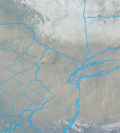
The sun has all but disappeared again. I can still see the smoke in the air, but oddly enough, it doesn't smell that much this round. I wonder if the worst of it is more aloft on this pass.
-
8 minutes ago, psv88 said:
Nasty plume of smoke flying through NE PA in your direction. Its not even close to being over.
Oh I don't think it's over. But if I can stay in that flow coming down the western catskills, I'll drop a shade or two of red. Small victories.
It looks like the absolute worst at the moment rides the turnpike south from NY to Philly.
-
An cautionary tale of improvement here. The smoke smell isn't as strong, and the sun is warmer than it has been all day. I just reached my high of 66 for the day.
It looks like AQI values to the north and west of the area are lower than they were earlier this afternoon. So hopefully that "fresher" air is moving in.
-
It's a touch brighter here in the past 15 minutes. I can hope.
-
The purple air website has multiple readings 400+ for the area. I could see one or two of them being a fluke, but not this many.
-
Temps in NW Jersey running upper 50s to low 60s, adding to the apocalyptic feel of things.
Some of the air quality spot readings are in the 300s and 400s between here and Syracuse. My eyes and sinuses are burning just sitting here in school. Insane.
-
1
-
-
And here it is. The orange glow and the eerie look. Sun is gone. My classroom even smells now.
-
1
-
-
Question. I'm looking at Air Now. Why is there such a large variability in air quality readings over such short distances? You can see green and red icons with widely different readings, within a couple miles of each other. It looks like they're all updating properly. Is it affected that much by the local geography?
-
41 minutes ago, JustinRP37 said:
So our options appear to be cool and smoky or hot and humid. Hmm decisions decisions…
Hot and humid please.
-
1
-
-
15 minutes ago, wilsonvoid1 said:
hi guys i have kids and this smoke is somewhat taking a toll on my health, the window in my kitchen is open about 2 inches? should i shut it completely or leave it open for the night, this is very concerning!
.I think the obvious choice would be to close it, and keep your house closed up tight until this passes. Ours is.
If you have an air purifier, I would use it if it's affecting your health. Maybe run an air conditioner too? Minimize your time outside.
This too shall pass, although the next couple of days is going to suck.
-
3
-
-
I was just panning around the website purpleair. The site is slow to load, but it looks like a couple of the stations are periodically topping 300 PM AQI. I don't know exactly what that means, but I do know it's the deepest red and highest category of alert.

June 2023
in New York City Metro
Posted
2.74" here last 24 hours. The Cocorahs map has the heavier amounts just to my north and west which adds up because the first round yesterday morning completely missed me but dumped 1.4" in about a half hour one town away.
Just noticed that. We actually had some sun early this morning so I was starting to think getting a short hike in. Then poof - the last few radar frames and it's back. Already added 0.04" to the total from above.