BaltimoreWxGuy
-
Posts
2,137 -
Joined
-
Last visited
Content Type
Profiles
Blogs
Forums
American Weather
Media Demo
Store
Gallery
Everything posted by BaltimoreWxGuy
-
The March Long Range Discussion Thread, Winter's Last Stand
BaltimoreWxGuy replied to stormtracker's topic in Mid Atlantic
A 992 tracking to our west. Definitely no Bueno -
The March Long Range Discussion Thread, Winter's Last Stand
BaltimoreWxGuy replied to stormtracker's topic in Mid Atlantic
Eh. It looks like the euro is setting up for a Rainer to me -
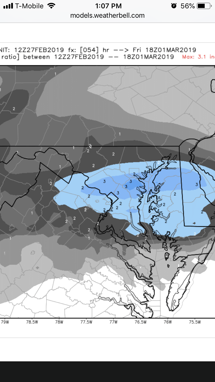
I’m good with it here in Dundalk...I’m in the 2-3” band
-

-
2-3” on 10:1 map for most of us on euro
-
GFS looks ok for about 1” for a lot of us. Nothing really near PA line though
-
ICON favors DC for 1-3”. Not much for Baltimore-north
-
The positive snow depth map only showing 1” might be a red flag but hey if you had to make a forecast based off the NAMs you would certainly have to go 1-3” for most areas.
-
Yeah I guess I should have been more clear about that. Anyway, clearly the NAMs are nice little storms. Are they right? I guess we’ll see. I’m highly skeptical but hey, I guess it could happen
-
It wasn’t premature at all...what I said was 100% accurate. Just turns out it doesn’t matter as it’s still able to amplify enough to get us a good band of precip
-
Despite the differences early on, the 3K still looks good particularly DC-North
-
It wasn’t. Compare hr 36 on 3K and 12K...now clearly it’s developed a nice burst at 41 so far but it was not as expansive in the Ohio valley
-
It appears at least early on that the 3K isn’t as juicy or as far north with precip...isn’t the 3K considered superior to the 12k?
-
Yeah NAM isn’t backing down particularly for northern Md.
-
The March Long Range Discussion Thread, Winter's Last Stand
BaltimoreWxGuy replied to stormtracker's topic in Mid Atlantic
I’d use extreme caution on the FV3 depiction for Sunday/Monday...I almost guarantee that’s how it won’t go down...no spacing at all between storms and rain to snow? Frontal passage basically. -
The March Long Range Discussion Thread, Winter's Last Stand
BaltimoreWxGuy replied to stormtracker's topic in Mid Atlantic
It’s crazy how the models have been keying on different waves all winter. Whether it’s the complex pattern or not, the models have been kind of awful this winter. Is what it is -
The March Long Range Discussion Thread, Winter's Last Stand
BaltimoreWxGuy replied to stormtracker's topic in Mid Atlantic
Just not enough spacing between waves on gfs. Not looking great -
One thing is for sure, whatever falls it’ll melt by noon lol
-
Gfs is a bit better particularly for dc but still nowhere near the NAM
-
Disagree...this is the type of system that the NAM over exaggerates on the northern extent of a jet streak when a low is way to the south. It’s out to lunch. I wouldn’t expect anyone to do better than a coating of snow with this.
-
The March Long Range Discussion Thread, Winter's Last Stand
BaltimoreWxGuy replied to stormtracker's topic in Mid Atlantic
Ouch. Rough hit. Not sure why anyone bought into the midweek farce. I could tell that looked sketchy. Gotta hedge our bets on Monday -
Euro and GFS combo I usually find works well. They both agree on a relatively weak, sheared out system. Gotta go that route. Friday’s dead for now. Let’s pay attention to Monday
-
The March Long Range Discussion Thread, Winter's Last Stand
BaltimoreWxGuy replied to stormtracker's topic in Mid Atlantic
Snow dog Holmes is on the case according to DT -
Why would we care about flood warnings in the south? We’re talking about the modeled QPF in this forum. Real QPF was less than modeled. That’s the only point. Let’s move on now
-
Lol it’s a baby threat. The best we can hope for is 1-2” with marginal temps. I mean sure that’s something but this isn’t really too much of an event