

DarkSharkWX
-
Posts
667 -
Joined
-
Last visited
Content Type
Profiles
Blogs
Forums
American Weather
Media Demo
Store
Gallery
Posts posted by DarkSharkWX
-
-
 woah
woah
-
 6
6
-
 7
7
-
-
2 hours ago, CAPE said:
NPAC jet extensions are more prevalent/expected in a Nino, and literally favor a +PNA. So that is NOT in and of itself the 'cause' of the warmth. The AO is neutral, and the NAO is positive. Shift those indices negative with that jet extension and we have a much more favorable/colder h5 pattern for the beginning of Feb. None of this stuff happens in isolation.


ik - i was just talking about the pattern potentially becoming more favorable for -NAO wavebreaking (along w the +SCAND lol) w the jet extension, and mainly the pattern after the transient favorable period before mid feb
-
looks like another jet extension will bring a big warmup for the country, but when it retracts it should bring back blocking(we've seen this before), probably around feb 10th
the -PNA from the jet extension along with a +SCAND will setup a pattern for -NAO wavebreaking, hopefully we can cash in on that period when it retracts
-
5
-
-
2 minutes ago, DDweatherman said:
I’d call the 18z euro a hold at worst, we’d lock that up right now if we could. Good thing 0z is going to continue the run good…
it got slightly better lmao
-
12/11: 2.1"
1/14: 0.2"
1/15-1/16: 5.8"
Total so far: 8.1"-
1
-
-
3 minutes ago, psuhoffman said:
There aren't many other 12" plus examples...but there are plenty of like 6-10" examples. Not having a NAO block severely limits our ability to get a 12" plus storm because even if we get a transient 50/50 its moving out and so any long duration slow moving storm, the kind you usually need to get a 12" plus storm...is going to have issues unless its times absolutely perfect. But we can certainly get a good storm that way. 2003 was time up perfect with an arctic high in a perfect spot and not just a 50/50 but an absolute BEAST of one that because it was so strong didnt move as easy.
do u think -NAO can restore in like mid feb?
-
has there been any examples of a 12"+ storm besides 2003 with a netural to positive NAO and w just a 50/50?
-
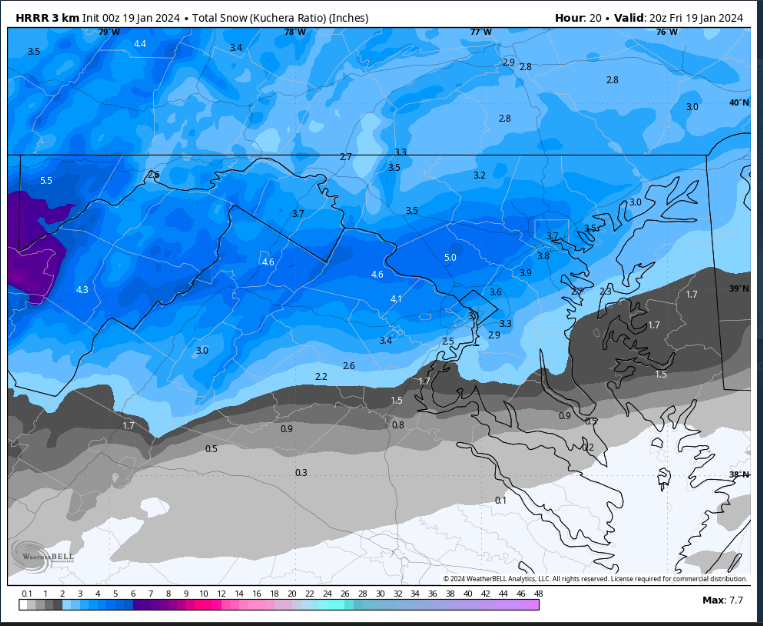
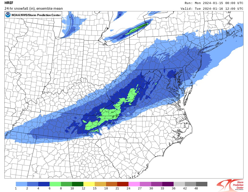
HREF 4-6"
-
4
-
-
2 minutes ago, Deck Pic said:
So NCEP ran the 1.33km Nam over our area at 0z. It only goes to 36 and it's still snowing when it cuts off

that exists? link doesnt work for me
-
Just now, Stormchaserchuck1 said:
It actually shows 2-4".. ratios have it changing over to ice briefly along I-95.
ratios are way higher this event i dont see a need to use positive snow depth change lol, it mixes for like 2 seconds before coming back
-
1
-
-
-
6" contour and not done snowing for hoco
-
5
-
-
euro probs would have been better if it went out further btw, better angular momentum and pna
-
4
-
-
-
nice uptrend!

-
19
-
1
-
-

basically guaranteed inch on GEFS, probs around 4-5" mean w/ 0.3" qpf and adjusting w 15:1 ratios-
7
-
-

way better this run w the tpv and main wave seperation(12z vs 18z vs 0z)
-
4
-
-
tomer said that the euro weeklies keep cankicking the feb pattern though?? personally i dont see it but idk
-
59 minutes ago, CAPE said:
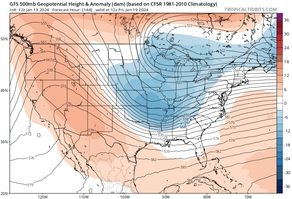
Hell of a ridge bridge between the retrograding -NAO and the PNA ridge progressing eastward. A factor that could contribute to the 20th storm potential coming together too late/offshore. If it amps enough and develops a wave break in time the GFS scenario might be a real possibility. Also would give us our coldest temps in a long time followed quickly by a late Jan warm up.


Any January 'thaw' looks short lived though as the advertised pattern reshuffles to a -EPO/+PNA look for the end of the month. Colder air should be in place again by the beginning of Feb.

that looks good, but are you concerned about the +NAO for the end of jan a bit? +PNA won't allow for -NAO wavebreaking, atl the way its advertised now
atl we finally have cold air lmfao -
named, 7" BWI

-
1
-
-
9 minutes ago, baltosquid said:
Much angst over the op (at first) but the GEFS continues its happy trend west, at least I would argue this was a tick west.
overall trend

-
2
-
-
-
-
9 minutes ago, Imgoinhungry said:
What is the difference between the two?
.3km is much more high res and can sniff out ptypes better
models basically useless this close tho-
1
-


Jan 19th Storm OBS Thread
in Mid Atlantic
Posted
likely final total here in gaithersburg is around 6.4"