

DarkSharkWX
-
Posts
695 -
Joined
-
Last visited
Content Type
Profiles
Blogs
Forums
American Weather
Media Demo
Store
Gallery
Everything posted by DarkSharkWX
-
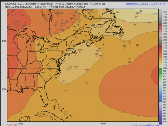
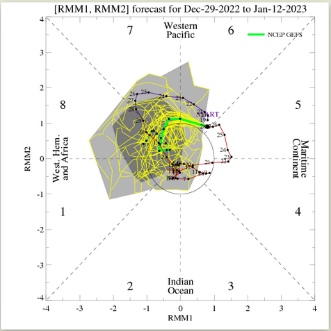
Some signal for a 50/50 low as well
-
happy new year everyone! here's to another year of tracking
-
2 storm systems phased together and then a near-stationary UL ridge over maritime provinces of canada prevented it from going NE and instead it moved east. this also made the storm stall off the coast before eventually moving OTS
-
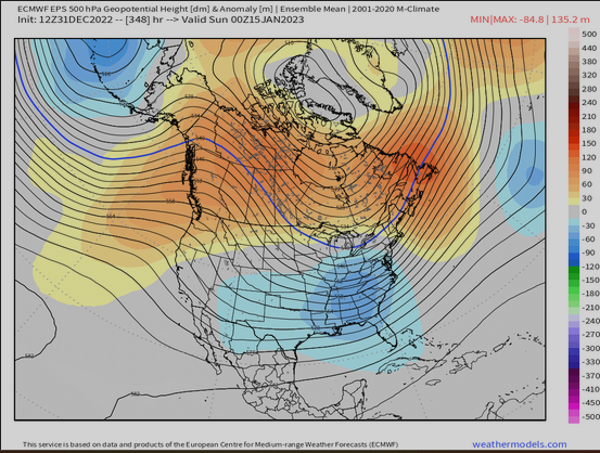
EPS looks good as well likely reacting to MJO going in favorable phases
-
I assume more ensembles/models will start to adjust to this look more in the LR with the MJO going into phases 8/1
-
Pretty sure one of George001's post got like 40-50 lmao
-
-
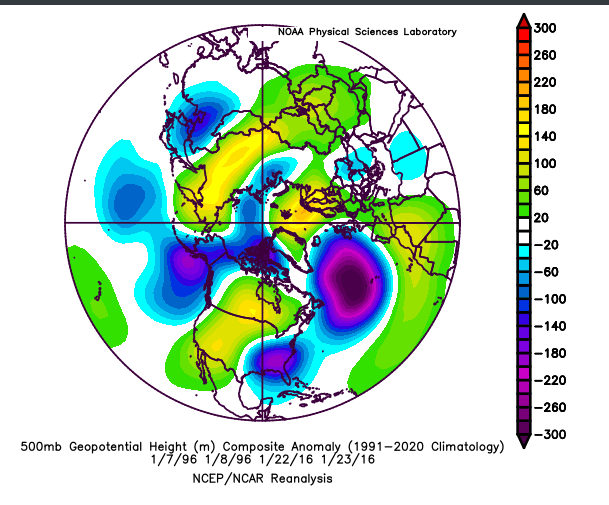
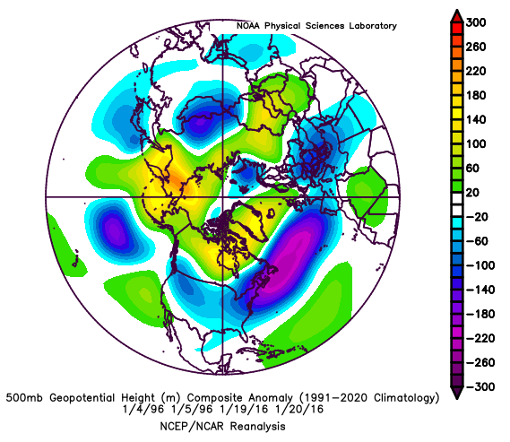
Maybe there was an -EPO prior to the storm allowing cold air to seep in? But yeah, most of our KUs have happened w/o -EPO and it isn't necessary for us to get them. One thing that all of them clearly have is a Canadian high, 50/50 low, and a ridge over the Rockies. HL blocking/-EPO isn't fully necessary to get a good storm(as proven by 1996 and 2016).
-
Here is all of the 500h pattern for the major snowfalls our area has had since 2009-10 winter(excluding the major KU storms, and storms that only gave major snowfall to far far northern areas and/or high elevations). Just goes to show that we dont need a perfect pattern to score good snowfall in our area, some help from atlantic/pacific can be used well(as you said) edit: oops accidently added december 13th instead of jan 13th
-
Euro extended/weeklies, GEFS, and GEFSX has MJO going through Phase 8. An -EAMT event would retract the jet back and since its overextended rn, form a +PNA. Along with the NPJR, MJO p8 would further enforce +PNA and blocking(along with +SCAND). While I'm still skeptical about it, this is an encouraging signal to see, and changes in the modeling will probably occur sooner or later if this signal continues to stay
-
For IAD, ~85% of all snow falls past Jan 1st(3.1" falls in November and December, 17.9" falls in January, February, March, April) For BWI, ~87% of all snow falls past Jan 1st(2.6" falls in November and December, 16.7 falls in January, February, March) edit: oh mb you meant after Jan 15; ~72% for IAD and ~74% for BWI
-
Yeah, pretty sure DCA had no measurable snow before Jan in 2014-15, 2015-16, and 2021-22, and then things started to ramp up after the start of the New Year
-

The Seasonal Snowfall Futility Markers
DarkSharkWX replied to North Balti Zen's topic in Mid Atlantic
id be interested to see this for IAD or Damascus(even though there isn't much data for Damascus). i'd expect the same downward trend, but maybe its decreasing less/more, etc. -
Another presentation about the NPJ if anyone is interested in it: https://www.weather.gov/media/sti/nggps/Presentations 2017/08 NGGPS17_PImeeting_Bosart.pdf
-
when the jet retracts we should at least get a transient +PNA, +SCAND showing up as well which indicates that Atlantic should get fixed soon, how long this favorable pattern lasts depends on how long jet stays in favorable place. def not a bad look below with +PNA over Rockies, ridging over Canada and Arctic w/ Aleutian low and +SCAND which puts pressure on PV
-
-
GFS fantasy run
-
yeah lmao, chat gpt is pretty good with stuff like this(as long as it is given proper set of directions/data), i just changed a few parts
-
Paraphrased: Models use pressure as a vertical coordinate system(500mb, 750mb, etc.) rather than height(10000 ft, 20000 ft, etc.) to work well. Geopotential height patterns at the 500mb pressure surface show where warm and cold air masses are located, with higher geopotential heights indicating warmer air masses and lower geopotential heights indicating colder air masses. When cold and warm air masses meet, wind is produced, with the strength of the wind being determined by the strength of the temperature gradient between the air masses. This wind controls the flow and track of storm systems.
-
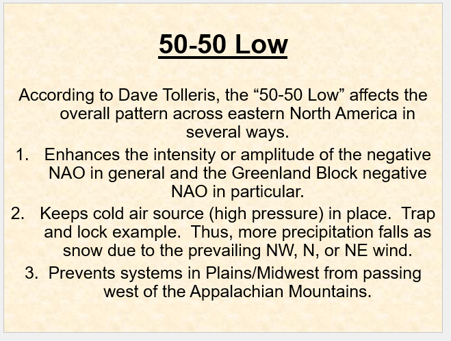
Here is a PPT that explains the significance of a 50/50 low(shows examples and explains more in detail), it prevents storms from cutting inland, strengthens the block, and locks high pressure in place 5050low.ppt
-
Fair enough - I can see what you mean; still wouldn't say pattern was dominated by SER/-PNA, and as others have said sometimes its just luck(if the frontend was colder for just a bit longer or it snowed for a bit longer in the right areas we would have gotten accumulating snow)
-
Yeah most of the cold was placed in the Central US because of the lack of a 50/50 low and the ridge not being east enough over the Rockies. Had we had those 2 factors, this December could have gone a lot better
-
much more different lmao
-
From Dec 15(around time when we were expected to go into a favorable pattern) - Dec 24(latest date available) there doesn't seem to be any sign of a -PNA/SER at all. The PNA not being east enough(not over the Rockies) and the lack of 50/50 are one of the factors that contributed into the pattern not doing well.
-
tbf correlation doesn't equal causation - most of those years that had <1" for you before Jan 1st were bad for everyone because of a strong -PNA and SER which is different from what we've had so far and what is being shown on guidance the reason why we will go AN for the end of dec thru first week of jan is because of NPJ overextension - quite similar to a strong nino pattern


