Benjamn3
-
Posts
274 -
Joined
-
Last visited
Content Type
Profiles
Blogs
Forums
American Weather
Media Demo
Store
Gallery
Everything posted by Benjamn3
-
I personally love the euro/ol Uncle Ukie lol.
-
Local stations predictions this AM in my area. Calling for quite a bit more than the NWS. As well as about a 10th to a quarter inch of ice.
-
I’m hoping the same. It must be a tough forecast for our local Mets. I’m thinking we will do fairly well I have a good feeling this will overperform for us. The CAD west of the blueridge is always underestimated.
-
Our area really is all over on this one. I’ll also be curious to see how the CAD helps us. I’m up in Eagle Rock so I’m thinking we will see more snow than is being shown on the GFS
-
How is it looking for areas north west of Roanoke close to the WV boarder? Been riding that snow mix line.
-
Sorry about that, I forget about the banter page a lot.
-
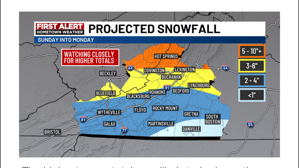
South/Central VA crew watching/hoping the south trend continues for sun/mon

-
The latest from Blacksburg, hopefully they update frequently. LONG TERM /SUNDAY THROUGH WEDNESDAY/... As of 200 AM EST Thursday... Key Messages: 1) Confidence is increasing for a wintry mix of precipitation lingering into Monday. 2) Arctic air will push temperatures further below normal during Tuesday and Wednesday. Monday could feature a plethora of precipitation types due to a Miller B system tracking eastward across the Appalachian Mountains. While the parent low dissipates in the mountains, a second area of low pressure should develop across eastern North Carolina and head offshore. A wintry mix will continue through Monday until a dry slot can squeeze its way northeastward along the Blue Ridge as the system departs. Although details still remain murky, the overall consensus depicts rain spreading northward in parts of North Carolina and Virginia where temperatures try to rise above freezing. However, this milder air will have to fight against colder air near the surface that will keep a mix of freezing rain and sleet in play.
-
I personally am hoping the warm nose isn’t much an issue here in SW VA. It’ll be interesting to see where the snow mix line ends up. I’m thinking just south of I64. Just depends how the CAD sets up. I’m also hoping it trends a little further south. I hate dealing with Ptype issues.
-
January: Medium/ Long Range: May the Force be with Us....
Benjamn3 replied to Weather Will's topic in Mid Atlantic
Over here in VA in the Allegheny mtns hoping the south trend continues like.
-
January: Medium/ Long Range: May the Force be with Us....
Benjamn3 replied to Weather Will's topic in Mid Atlantic
I will deff take some cold in place then hope to thread the needle. Can’t make the play without you’re most important player on the field. Not to mention ground temps when the snow shows up. It’s nice to have everything good and cold so that first flake sticks. -
January: Medium/ Long Range: May the Force be with Us....
Benjamn3 replied to Weather Will's topic in Mid Atlantic
Naaaa knock it about 75 miles to the South West
-
Well, get the keys ready cause I ain’t stopping my optimism. Ain’t like I’m hoping for 25 and snow, 48 and pleasant is fine by me. I’ll bet you’re a joy at parties. Lol I’m currently building a farm so I should hope for warm.
-
Just an opp run. Seems kinda split in my oppinion, on what the 10 day period holds. Looks seasonal to me, not shit the blinds but boring. Which for Xmas is just fine.
-
I think that’s a lot, to much even. I think 4” of anything is respectable.
-
Does anyone ever think maybe all this is a “watched pot doesn’t boil” kind of thing. Maybe if we quit watching it, we will have another 09-10 lol
-
I don’t know about yall but I just want it to be seasonal on Christmas Day. I don’t think that’s asking too much. Lol
-
Fast forward to 6:30 tonight. “That looks great, look at that would ya look at it”. It’s a roller coaster in here. Lolol
-
Lock that sumbitch in. Lol
-
I’m just glad it’s not 59 lol. Y’all getting crazy asking for snow Xmas week.
-
Concerning the Euro around Christmas.

-
SMH you can bet the bank this is the sumbitch that will verify 15 days out.
-
What I’m hoping as well. Let it fade for a week or so then come right back around The 20th. It’ll be close but if you go by the 6 week rinse repeat schedule it may work out.
-
Share with the rest of the class. Lol