

Stormchaserchuck1
-
Posts
3,522 -
Joined
-
Last visited
Content Type
Profiles
Blogs
Forums
American Weather
Media Demo
Store
Gallery
Posts posted by Stormchaserchuck1
-
-
12 minutes ago, brooklynwx99 said:
my guess is that you get a vigorous wave coming onshore around the 20th, the Aleutian low retrogrades, spiking the PNA, and that's how you get clobbered. everything is in place there, TPV is perfectly elongated
I would say we get something before then. The unretrograded N. Pacific low in the Gulf of Alaska is really a recipe for a monster, if everything times right.
Look at how the Euro amped up this pre-Valentines wave. https://ibb.co/tLxxhB9
-
 2
2
-
-
2 hours ago, Blizzard of 93 said:
The SOI continues its tanking, which it has been doing for the last several days.
Here’s the latest.

That fits the double blocking pattern https://ibb.co/2P1Pjdt
Higher precip in the SW: https://ibb.co/Fxv790Y
-
2 hours ago, brooklynwx99 said:
now this is more like it
Their analogs keep the cold around for a while. This is up to Day+15
-
1
-
 1
1
-
-
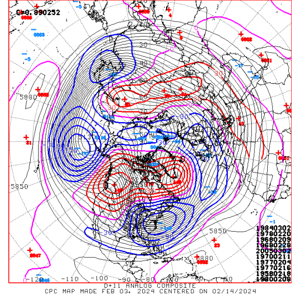
The 12z GEFS looks cold for Feb 19-20, with a new signal to have a block in the Arctic Circle north of Alaska!
Now it's a matter of amplifying the STJ, because we have two perfect low positions in the 50/50 spot and south of the Gulf of Alaska.
That High pressure north of Alaska though is called -EP/NH and has a strong tendency to be a cold pattern:
US Surface Temps https://ibb.co/gwg8WWB
-
2
-
-
18 minutes ago, NorthArlington101 said:
Is that our HECS?Yes.. something is going to need to change between H5 and the surface though. -EPO is an underrated cold pattern.
-
Crazy if we get rain with this H5 https://ibb.co/YR9gdSH I guess they will back off of it on future runs..
-
12 minutes ago, brooklynwx99 said:
wow
A trough in the east... you would think with the Atlantic blocking hooking up with -EPO at 384hr of GEFS you would have more severe cold.. I guess the Euro is the slightly warmer model right now.
-
Day 10 Euro tries to develop -EPO/+PNA/-NAO.. it's early, but I like that there are +heights over AK vs the GEFS at that time.
-
1
-
-
4 minutes ago, psuhoffman said:
You’re missing the point. Yes there may be a lag for it to couple and cause another deep blocking period. But that’s irrelevant when the nao is already tanking! We just need it not to quickly bounce back. Yes maybe the nao has another crazy dive in March because of the SPV collapse in Feb but what’s most important here is that a weaker SPV means the already -nao is unlikely to recover any time soon.
I guess the point is that the -NAO may be more likely to sustain giving the 10mb warming expected to occur ~ Feb 15-16.. I'm just saying based on how it hasn't held for like 14 years it may be a little harder than it seems..
-
7 minutes ago, psuhoffman said:
How do you even judge a “lag” if the nao is already negative when the SPV weakening happens?
A # of composites showing the same thing. Sometimes it would go -250, -250.. -100, 0, -50, -250, -300, -350. But the thing is, there were a lot that went +250, +150, 0, -150, -250, -350... so after like 100 examples, you had a clear time lag that had the highest correlation between 500mb and 10mb (and it was not D+0), the "+time" was about 3x stronger. There was also not less +time -NAO's if the D+0 nao was negative.
-
9 minutes ago, psuhoffman said:
I don’t get the lag talk. The lag is when we have a beast of of TPV and need to wait for the SPV to impact it. The TPV is already in the process of collapse due to pacific forcing combined with Atlantic wave breaking. The SPV collapse will simply prevent a quick recovery and foster additional -nao cycles. This is also very similar to 2010 when repeated SPV hits acted in conjunction with troposphere forcing to create a long lasting and extensive blocking regime.
You do a lot of researches, it could be worth it sometime to go back through the daily climate composite dataset and compare 10mb to 500mb. I found that negative events (strong 10mb vortex) correlated to +AO at 0-days all times of the Winter, and there was a strong lag-time (+10-45 days whether it was early or late in the Winter), regardless of if, there was a strong -NAO the day of the 10mb warming, for almost all warming events. The linear difference in times of the year with 3x the average -NAO +lag vs initial was a very compelling find, based on 75 years of data.
-
3 minutes ago, brooklynwx99 said:
there isn't a lag this time. the SPV and TPV are coupled quickly looking at NAM plots
As we get into March, the typical lag is +10-15 days, vs +45 days in November, but history says that's how it usually happens.. Even in the examples where there would be a monster -NAO the day of the 10mb warming, it would usually come back to spike up later in the allotted time.
-
2 minutes ago, psuhoffman said:
2010 really is the best analog to this progression. Just everything is displaced about 2 weeks like you said. It’s nearly identical in how it’s getting from A-Z in almost every way. I’m just careful throwing that around since it’s literally our snowiest period ever. That took some luck on top of the great pattern. But this has that level of potential. At the least it will be difficult to escape this without a significant snowfall.
2010 is the last time I saw so much arctic blocking.. easily carrying over from the Atlantic into Alaska with >+100dm everywhere along the way. Now for it to hold as we get closer..
-
1
-
-
11 minutes ago, frd said:
When do you think the - NAO starts to relax, because that will be important as it is related to storm potential during the relaxation period.
If we have another wave 10mb warming, it may be longer into March.. but we are still in a +nao era, as like 8/42 Winter months lately have come in negative or something like that, and big -NAO's lately have been lasting an average of 8-12 days. I think it may come up sooner than expected, maybe at the end of February. Then it might go negative again in March. GaWx in the ENSO thread said yesterday's models had Feb 15-16 as the 10mb warming peak, which would favor -NAO ~March 2-7.
-
1
-
-
9 minutes ago, frd said:
Interesting
I've seen a lot of people say "it's propagating or not" (when the 10mb high/low connects with 500mb/surface at Day+0).. but it doesn't really happen like that. Correlations I've found is that no matter what the NAO signature is a 0-day, it has a higher correlation +10-40 days (depending when in the Winter it is), even if it's "making it to the surface" or not at 0-day. The Jan 13-24 10mb warming does have correlation to -NAO conditions ~Feb 3-20 (or sometime around there), just based on 75 years of data. It's not something that can be easily seen "as hitting now or not" at Day-0, although sometimes the mechanism of the 10mb warming stretches all atmospheric layers.
-
1
-
-
-NAO/-AO really showing up as a beast on the 12z GEFS
I haven't seen it cover such a large area of the Polar domain in a long time.. (It's a 384hr model though). It seems like we've been at 384hr for a while, but they are getting better day-by-day.
The problem with NAO getting too strong is, it can suppress storms. Here's a 0.4-0.5 precip correlation over the Mid Atlantic in February: https://ibb.co/8zrBxYf
That's why a lot of big storms happen when the block lifts out.. But I do think energy in the southern US along the STJ is the sign of a wetter pattern.
Really a cold pattern though, with the Atlantic ridge connecting with -EPO.. almost all you can ask for.. Still has the near 50/50 low, south of GOA low, central-southern US STJ energy to come east for Feb 19-20.
-
2
-
-
1 hour ago, WEATHER53 said:
Is mid Feb (10th to 19th) still on or delayed to 20th to 29th?
I'd say it's on (~ Feb 19) unless the upper latitude index pattern changes (which it hasn't yet). It also looks like an active STJ starting around that time so well have to just time something right in trend. It was always suppose to be warm before Valentines Day.
-
0z GFS builds the +PNA at day 11! 952mb
-
2
-
-
Leading up to a triple phaser, or a blizzard, you generally want the N. Hemisphere to be colder anomaly. It's pretty simple, but almost all the major storms have it, days to weeks before, the Hemisphere temps dropped, or were colder than normal overall. Here's before March '93.. this is in the midst of '48-20 averages (93 is 65% of the way through).. colder hemisphere
-
29 minutes ago, Terpeast said:
Case in point, take away that 80 degree day would lower our Jan average by at least a full degree. We’d have been closer to average
It does feel like it's been a colder Winter. A lot of low cumulus, and days in the 30s and 40s. These clouds are really pretty for the last 2 years, and I think we are bringing in a better overall period for snow/cold (although maybe several years, even a decade?, out). It's not the same composition as 2005-2017, where things were melting fast, and not refreezing, a lot of sunny bright days
-
3
-
-
1 minute ago, psuhoffman said:
EPS has been nailing the long range a lot this winter.
What about January though where it had several runs going back to September of us being -1 to -4?
-
31 minutes ago, psuhoffman said:
We have threads for specific threats once they are inside 5 days or so. But that’s a different kind of thread. We know want the general pattern is going to be by 5 days. Discussion inside 120 hours focuses on a specific event and the details of that threat not so much patter generalities. The problem with a permanent day 1-5 thread is they 90% is the time there is no specific threat inside 5 days and so the thread would be dead most of the time.
And the long range models will keep getting more and more accurate, and going out further and further in time! It's the point in the technological revolution we are in. I'm kind of disappointed because manual methods like analog research are no longer as valuable. The GEFS and EPS are still not performing all that great, though.
-
1 minute ago, IUsedToHateCold said:
All you need is a passport, a car, and some cash
For real.. let's do it
-
11 hours ago, stormtracker said:
Ok, so the story about this guy...if there are any doubts everyone on staff will confirm my story
So back in day, his name was Earthlight here. Good poster, knowledgeable dude, from the Philly forum. We liked him. So we put him on staff. So we started to notice that the Philly forum was getting a bit light. Eh, no big deal. Come to find out from a few anonymous PMs that this dude was using his position to poach Philly people from this board to his own...the entire time he was a moderator on staff here. Look, people are free to start a board and go wherever they please. That wasn't the issue. It was that he was a trusted staff member here and was actively poaching members and never resigned and was active in the mod forum. That was years ago and it's funny now and I'm sure he's a good guy...but back then we were all competitive and engaged in the stupid board wars of the early 2000 teens. It was a fierce pitched battle. Many died. A true widow maker. We've all signed a treaty of Versailles, so I'm sure that will never happen again. A war to end all wars.
But all of us admins are over the entire thing and I wouldn't even care if he posted here. We just thought it was a shitty thing to do at the time.
He was like 17 at the time lol.
I used to post with them when I was also in high school and college.. they were fun, easily deep. I'm glad he's a successful person now with some good storm chasing videos.. looks like he's having a good time.

El Nino 2023-2024
in Weather Forecasting and Discussion
Posted
Look how much we recently lost the warm subsurface anomalies
https://ibb.co/tX8w6Pj
Big disconnect between the surface and subsurface right now (+1.9/0.0) The start of the end of the El Nino, after a few weeks it should probably start to sharply drop to more Neutral conditions by the Spring.