

Stormchaserchuck1
-
Posts
2,067 -
Joined
-
Last visited
Content Type
Profiles
Blogs
Forums
American Weather
Media Demo
Store
Gallery
Posts posted by Stormchaserchuck1
-
-
17 minutes ago, clskinsfan said:
Dude. You just posted a map with SIX FING INCHES of pdf and called it dry......ISSUES bro.
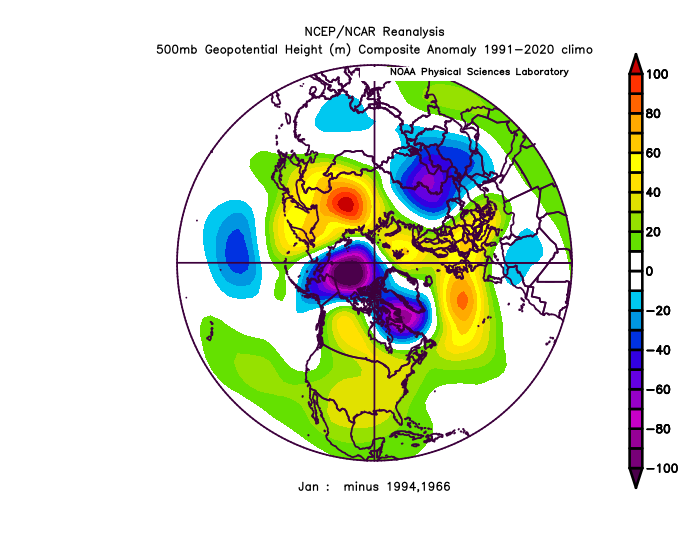
-NAO's in December have been historically dry. Not this one. 1996 was the only exception and the similarity is that there was warmth in the ENSO subsurface (before 1997 El Nino).
do you see my other maps(before +time)? water, water everywhere but noone pays $1 for water
Yeah I'm out bro
-
-AO doesn't carry.. slight tendency for +PNA
-
1 minute ago, 40/70 Benchmark said:
.23" RF today...Hi of 56
60 here.. nice High pressure-NAO, like always.
-
Just now, Maestrobjwa said:
I know I get the weenie tag for saying "Does a niño still work", but this is why I am genuinely curious about what will happen in our next legit niño (2018/19 is hard for me to count because it was a bit of a wimp strength-wise). To see just what those look like with where we are now climate-wise.
It seems like they are getting progressively "less uniform" (our last strong Nino 15-16 was followed by 6-7 years of -PNA
 )
)
-
4 minutes ago, psuhoffman said:
Fixed is highly subjective
I just think it's interesting.. watch it happen. I'd take a +NAO these days and in general. We are switching to a lower atmosphere pattern I think.
-
6 minutes ago, psuhoffman said:
there is a lot of assumption that once the -NAO pattern breaks our pac issues will be alleviated.
Yes.. maybe we will have -NAO all Winter.. could be the same to worse.. (I edited your post)
-
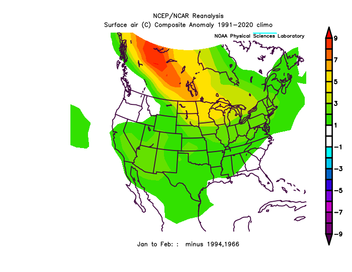
*If I can 1 more post this. It was Dec-Mar. A 0.40-0.50 correlation/above random for +NAO Jan-Mar, based on Dec -PNA, (since 1948, 75 analogs. top 20/75 analogs).
-
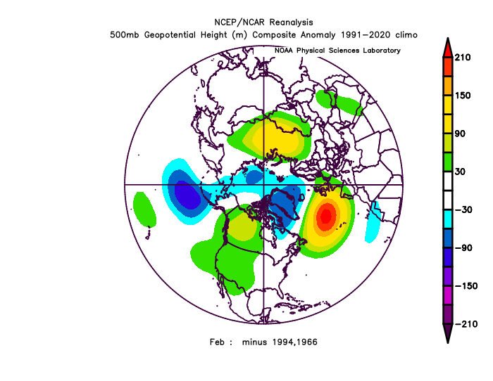
Check out my research from last Winter as to what a +PNA Dec means for the rest of the Winter. (last year was the #1 strongest PNA on record, per 500mb)
20 analogs, that came out at +100dm -PNA for, Jan and Feb! same 20 analogs came out ta a +70dm +NAO for Jan and Feb! The NAO is probably of more significance because same things correlate the same going forward, but the NAO is not so connected... so, if the PNA comes out like 18z GFS ensembles have, making it a top 5 Dec PNA on record, it's a strong +NAO, -PNA signal for Jan-Feb combined. That's just roll-forward, but I was surprised how well it worked out last year.. The +100/+70-2months dominated other things that were conflicting indicators in early January, like ENSO developments.
-
8 minutes ago, ORH_wxman said:
Western trough is giving everyone PTSD….definitely from last December.
Patterns aren’t the same though. If the western trough decides to dig to Baja through Xmas, then maybe but I don’t see that and guidance isn’t showing it either. Lots of emotional hedging going on I think. The pattern should produce plenty of threats imho.
Notice how LR models skew reacts strongly to current conditions?
-
 1
1
-
-
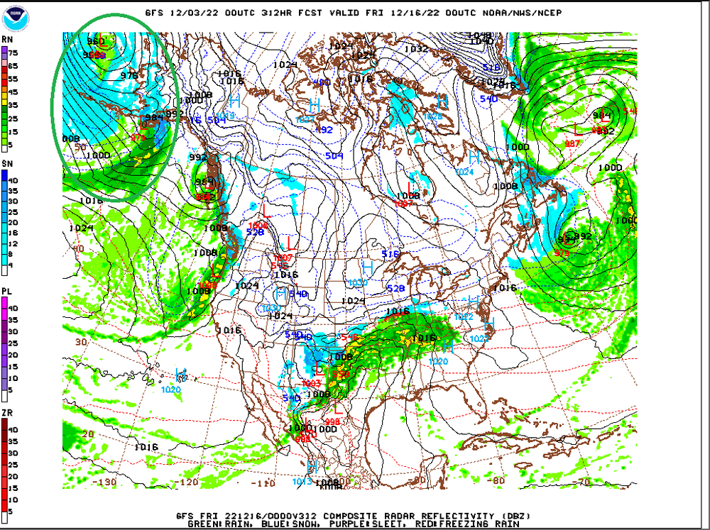
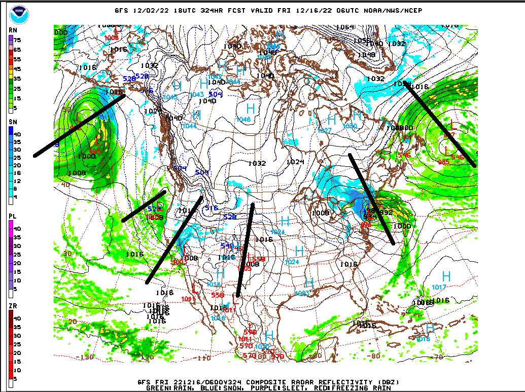
18z GFS ensembles looks really bad in the ER (extended range) day 15>beyond (trend)
-
Wet pattern, El Nino STJ. ladada
.thumb.gif.303acdfd256972cd0d4260c1d3c02746.gif)
-
2
-
-
14 minutes ago, Maestrobjwa said:
Nice article about the upcoming Niño:
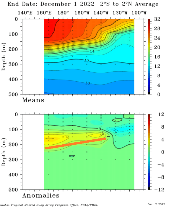
Yeah, the subsurface is really warm

A lot of the analog roll forward I did gave us 50% chance of Nino next year, 25% Neutral, 25% Nina(it's like 10% because we are 0/7 in 4th year Nina's). We'll see, events have been getting depressed in general, defaulting to 1998- cold period (-PDO) base state.
^The mid-subsurface at -200m actually correlates directly with the 500mb N. Hemisphere pattern, and is a reason, I think why, we are so wet.
-
Importance of the PNA.. I keep harping on how big of a miss this is, because of how dry -NAO/-AO's typically are
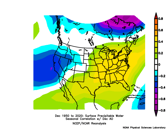
We are entering a very wet pattern at just the right time(NAO/AO), which is contrary to what's normal.
-
3
-
-
Here we go.. look at all this moisture
-
10 minutes ago, Maestrobjwa said:
Yes indeed. Another bullet point for the "Why ninas suck here" category, lol Overcoming a -PNA is tougher than I realized...and if that's the tendency with ninas...boo!
Now I'm curious...what did the PNA look like in 1995-96?
super positive.. #2 on record. 95-96 was after 6 straight +ENSO years 90-95 (record of this century +streak, also 89-90 and 96-97 were both -Neutral, but we didn't go La Nina 8/9 years (95-96 the exception) 89-98, which is also the longest streak of the last 200 years). After we were most negative ENSO 70-76, 76,77, 77-78, 78-79 were the coldest Winter's on record. 78-79 still ranks as #1.
-
 2
2
-
-
10 minutes ago, psuhoffman said:
The high latitudes weren’t as hostile as you’re implying some of those years. The numerical index isn’t as important as the actual h5 pattern.
Didn't you have 90" of snow those years? (I wasn't here)
-
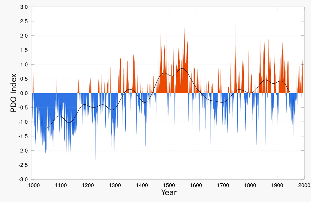
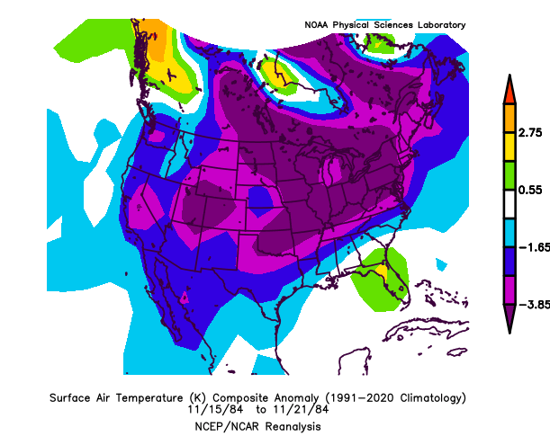
MacDonald and Case[24] reconstructed the PDO back to 993 using tree rings from California and Alberta. The index shows a 50–70 year periodicity but is a strong mode of variability only after 1800, a persistent negative phase occurring during medieval times (993–1300) which is consistent with La Niña conditions reconstructed in the tropical Pacific[25] and multi-century droughts in the South-West United States.[26]
0/7 I think 3rd year La Nina's going into the 4th year, since the 1800s.
-
1
-
-
15 minutes ago, psuhoffman said:
Problem is we’re too far south to survive any one major factor being awful. I agree the AO is the most important but it can be ruined if other things are in a bad way.
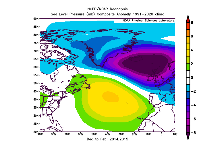
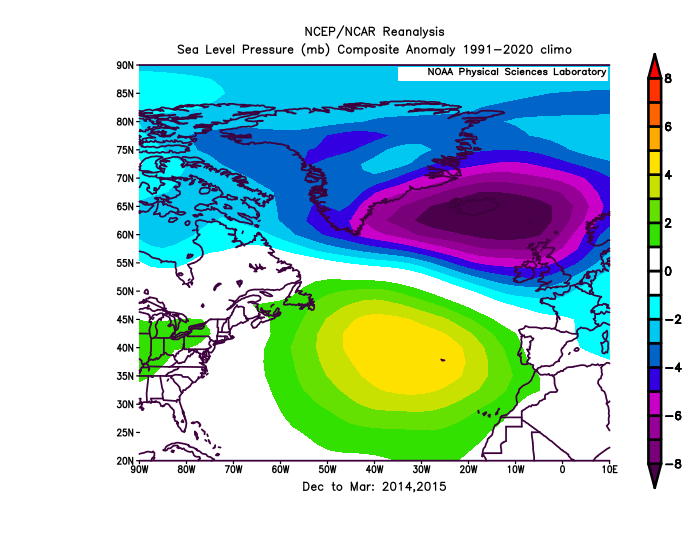
We can do it when ++NAO (13-14, 14-15, 92-93, 93-94). PNA is pretty untouchable.
-
-PNA is saturated now.
http://www.meteo.psu.edu/fxg1/HEMI500/5dayloop.html
Usually when it's switching from long term +PNA to -PNA, we can get colder, but not this time.. look forward to a rainy 15-20 days.
-
Look at this wave train
Maybe someone could run stats on how it goes PNA negative/neutral, coming out of >4SD -NAO (rain/snow?). Because the moisture will be there.
-
STJ is really active for 10-12 days with retrograding NW Atlantic low.. probably all rain imo, pretty high confidence lock, but something we have not seen in a while(such a wet pattern).
-
On 11/22/2022 at 7:39 PM, raindancewx said:
After our last two, only two, strong -PNA/-NAO's in long-wavelength season, since Jan 2013.. it gets cold (high pressure upper atmosphere lol)
-
Can you believe this +5-7F subsurface cancels itself out in the global + wavepatterns? (little relevance)
-
15 minutes ago, Eskimo Joe said:
This is amazing. Is there any chance you could run this for January and February?
Pacific and Atlantic have been matching too, at -0.70 correlation. A 4-5SD -NAO is going to be 3SD -PNA (5-6SD -NAO is going to be a 4SD -PNA) (3SD -NAO is going to be a 2SD -PNA, 0time). No snow for us for a while, at least through 384hr.
-
 1
1
-
 1
1
-
.gif.56b9ae1956e25b41068092b362587a8d.gif)


December 2022 Medium-Long Range Disco
in Mid Atlantic
Posted
Cliché
I don't know that people see my research though, because you can probably make monetary gain from it , because it's simple work. It's a long time at this point for information blackout re: responses. (Can't do anything if you're saying STFU to my outside point from 30 minutes ago.) Not a big deal.. but it's weird. calculated and no science (the response times). it's about respect too.