

Stormchaserchuck1
-
Posts
3,561 -
Joined
-
Last visited
Content Type
Profiles
Blogs
Forums
American Weather
Media Demo
Store
Gallery
Posts posted by Stormchaserchuck1
-
-
Really close for northern MD on the 18z NAM. Close, but a miss.
850mb temps are near 0 at hr63
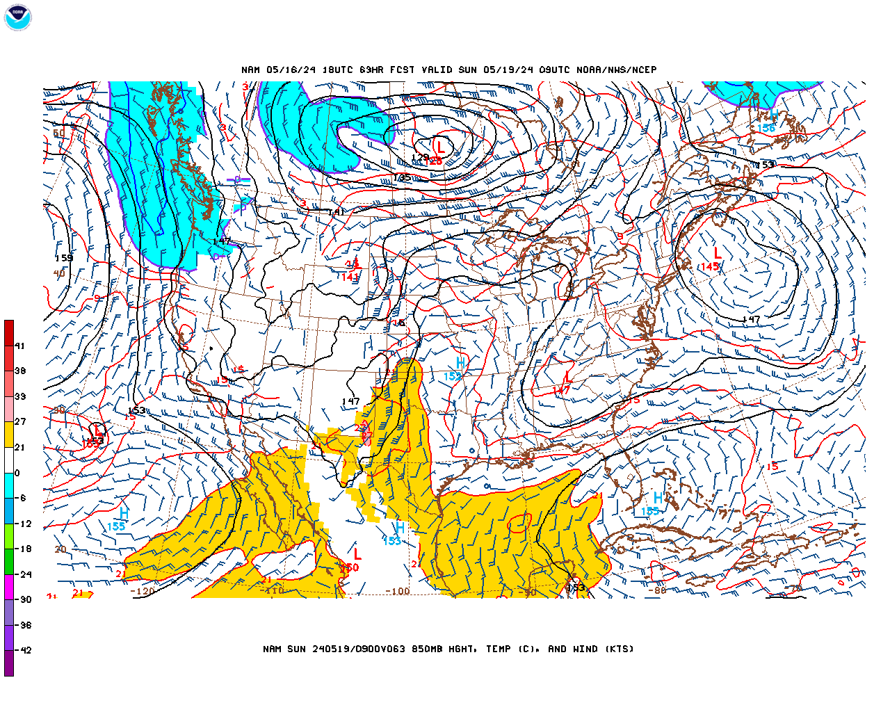
heavy precip close
Actual SL low is off of Ocean City MD..
-
NAM is definitely more amped this run
-
12z GEFS: PNA is negative for "PSU storm".. I don't care what the NAO is doing, the Pacific has overwhelmed the Atlantic constantly since 18-19. I mean, with the way it's trending, we may end up in the 50s. I still think PD is our best shot at snow, because it has the most favorable upper latitude pattern.
When subsurface ENSO changes happen, the N. Pacific pattern does adjust, sometimes even despite what is going on at the surface. It's a fairly successful forecasting method.
The -NAO/-PNA/+EPO, +NAO/+PNA/-EPO correlation is holding. Models were showing a break, but it backed off of the short term -NAO, associated with +PNA, and went stronger on long range -NAO associated with -PNA.
-
 1
1
-
 2
2
-
-
Really getting warm out today.
-
1
-
 1
1
-
 1
1
-
-
Warm out, 60 degrees, and I love it. I've been seeing all this Spring grazing birds, and they are moving like it's March-April..
-
13 hours ago, Stormchaserchuck1 said:
Nah, with the -EPO like that we should be colder.. that's why I said watch to see what they do over Alaska in future runs.
See PSU this is what's happening
-
5 minutes ago, WxUSAF said:
Obviously some scatter still, but 12z GEFS looks fairly bullish for the psu storm
We lose the -EPO and the Japan ridge is moving east. In verification, Surface temps would be a problem I think.
-
Did you guys see my NG research? It's since fallen down to 1.83 https://ibb.co/kxdbZSs
QuoteSince 1998, top 7 +Natural Gas analogs for February averaged 8.3, bottom 4 Natural Gas analogs for February averaged 2.2. We are at 1.97, the 3rd lowest on record in that time, fitting the extreme situation guideline.
Here are the top 11 +analogs for March.. based on Feb's NG price:
^that's Feb high/low NG price rolled forward into March (so a +1 month lead time). I don't know that March's warmth will be that extreme, because a lot of LR models (GEFS, EPS, Euro) are showing below average temps through the 21st, but we probably will finish the month above normal in the NE.
100dm is an amazing signal for something not even really related!
Furthermore, my analog set is 1998-2023. I have 11 analogs out of the dataset.. so 11/25 years.. 41% of the total. To have a +7F average anomaly (+ and - .. more - years, for the global warming skew.. 7/11 are cold analogs) for 40% of a dataset in 25 years is amazing!
-
1 hour ago, psuhoffman said:
Dude
NAO isn't even stronger on our side of the globe.
0.38 correlation in February to Air Temps
-
31 minutes ago, Terpeast said:
If it’s getting this bad in here, wait until I post my winter 2024-25 preview after getting shut out this feb and march

Yeah.. did you guys see the NOAA issued a La Nina watch
And it could be +QBO next year too.. and the last time we had +NAO we hit 80 in January!
-
Here's a strong NAO we had.. a few days ago
-
1
-
 1
1
-
2
-
-
9 minutes ago, psuhoffman said:
Ok you’re off in loony tunes land. That’s about as perfect a block as we can get. We don’t want more blocking than that. As it is it’s squashing everything for days to begin with and we have to wait for it to relax some.
It's not even a block.
And the tendency is for things to be warmer.
-
1
-
1
-
5
-
-
3 minutes ago, psuhoffman said:
This looks moderately negative to you? Or are you basing this on the op gfs again. If so can you please preface with that so we know to ignore everything after!
Yeah.. that ridge near Japan is approaching the same extent. It doesn't even close off a block. In the last year, we've seen 3 stronger -NAO events (March '23, early Dec '24, Jan '24). GEFS is a weaker signal right now though, and 6z is more recent.
-
1
-
-
2 minutes ago, mattie g said:
On which ensembles did we lose the 50/50?
-
This isn't that bad from this range.
What I don't like is the loss of 50/50 low on ensembles.
-
1
-
-
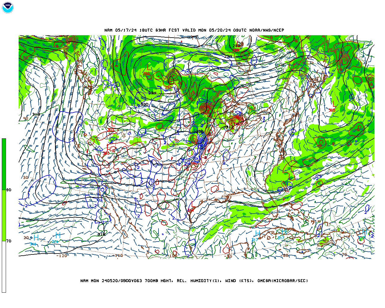
This does not hit northern MD
-
Now on models: The NAO is moderately negative for 84 hours, and that's about it (hrs 204-288)! Compared to some recent episodes, the Polar ridging doesn't look impressive, it barely even closes off any blocks. +250dm max (-epo/-ao) in February is not that much.
The 50/50 low has trended much weaker for PD threat.
-
A lot of ensemble variation still on the storm. Some miss it completely to the south.
Usually when there's a bombing low pressure, there is a wider range.
-
5 minutes ago, psuhoffman said:
And I said I’m frustrated. I expected colder. Something similar to 1958 and 2010. I didn’t said I’m throwing in the towel or changing anything yet. Sometimes people overreact to every random thought I post.
Nah, with the -EPO like that we should be colder.. that's why I said watch to see what they do over Alaska in future runs.
-
You guys did say that the Atlantic was warm.. in the south-central and Caribbean SSTs are where they usually are in July?
Here's a 591dm High over Dominican Republic. https://ibb.co/bL6GYZQ
^That 50/50 low is a little north, and while it is a -AO, it may also be a neutral to + NAO. https://ibb.co/7z7z3FZ
-
I don't know.. I guess the -NAO isn't strong enough.
-
2
-
1
-
-
42 minutes ago, PrinceFrederickWx said:
So when does the 2010 pattern kick in again? By this time in 2010 I had over 50” of snow. This year I’ve had three glorified cartoppers and a week’s worth of cold.
The sad thing is, ultra favorable periods are the only ones producing.. This will be our 3rd round of strong -NAO. Anything without a -NAO/+PNA in place may finish the year "0".
-
1
-
1
-
-
Actually somewhat big changes on the NAM short term.. I guess that's why everyone loves it so much
-
1
-
1
-
-
Looks good.. the Euro weeklies have had a very favorable high latitude pattern for US cold for several runs/a long time now.. Interesting to see things so far apart for March. Late February Stratosphere warming favors some -NAO conditions in March, too.
2024 Valentines Day Who the Hell Knows - Comeback Thread
in Mid Atlantic
Posted
18z Hrr fwiw was colder than the NAM with the 0 line at 48hrs
https://ibb.co/s1FZmsS