LakeEffectOH
-
Posts
299 -
Joined
-
Last visited
Content Type
Profiles
Blogs
Forums
American Weather
Media Demo
Store
Gallery
Everything posted by LakeEffectOH
-
Well, I've noticed the nicest day of the week is usually Monday, and the eclipse falls on a Monday, so...that may help us. A little...
-
Anybody care to guess what the weather will be like on Eclipse Day (4/8)? According to one Wx vendor, precipitation is expected to be above normal during the first half of April.
-
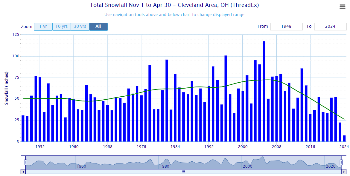
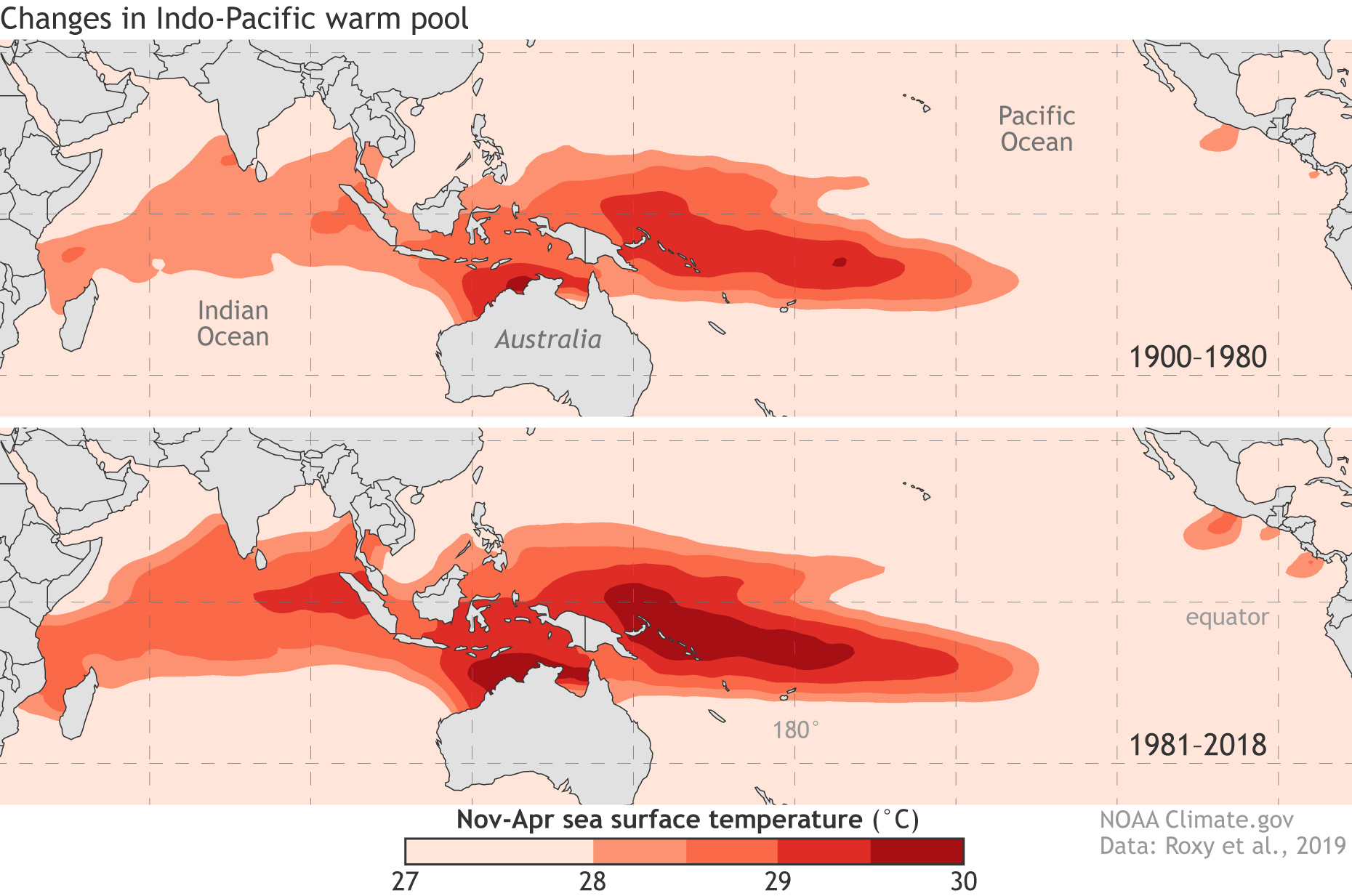
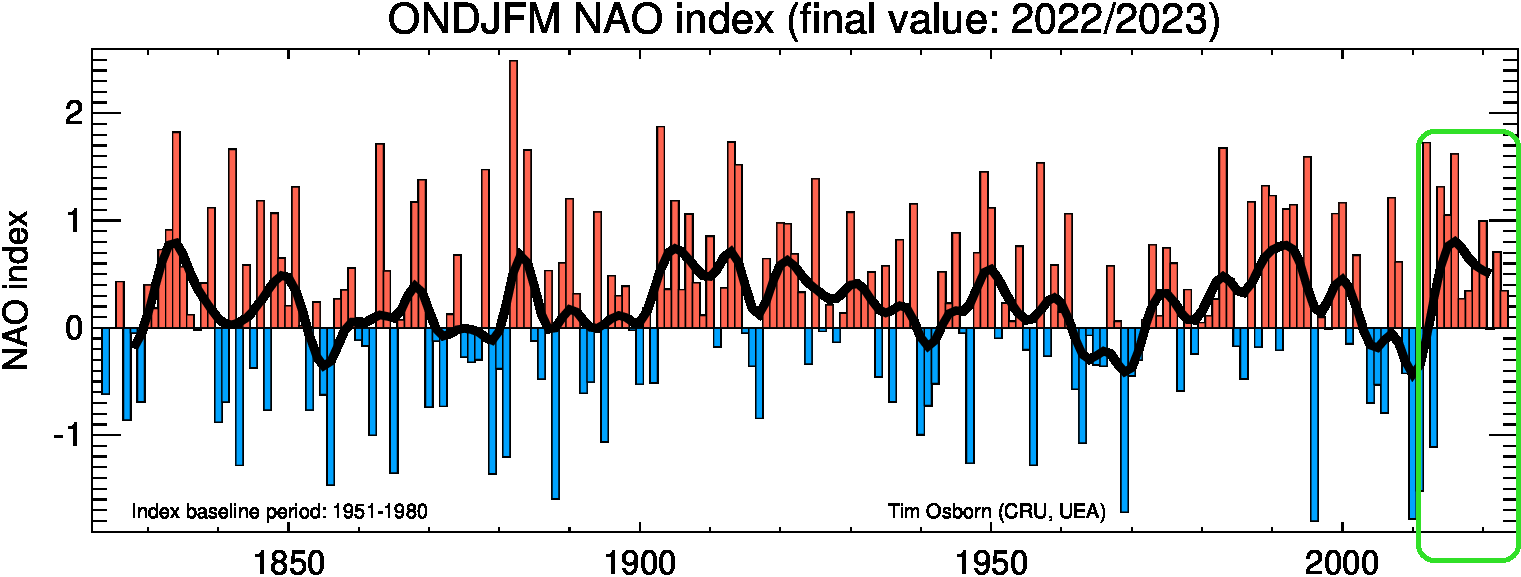
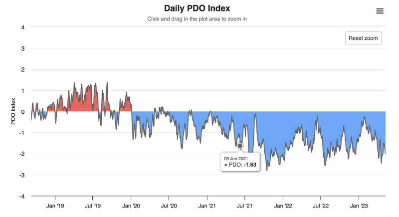
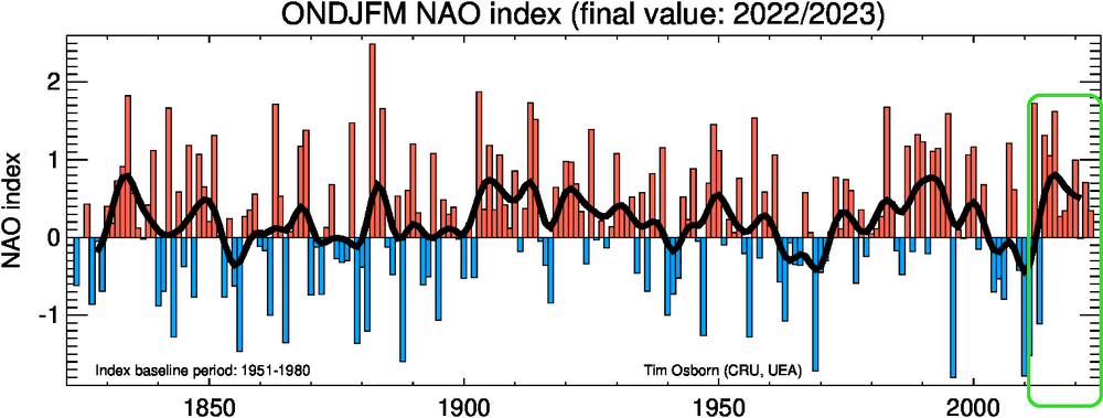
OHweather, A little break from the current snow event... What are your thoughts about the recent crash in snowfall totals measured at CLE? Link: https://xmacis.rcc-acis.org Here are some of my thoughts on possible contributing factors: Recent tendency of the MJO to linger in the "Bad phases" (4-7); The changes in the Indo-Pacific warm pool could be a factor in this. Expansion and warming of the Indo-Pacific Ocean: A strongly negative PDO over the past several years: Link: https://www.worldclimateservice.com/2021/09/01/pacific-decadal-oscillation A greater tendency of the winter NAO to be positive, especially in the past 10 years, (circled in green): Link: https://crudata.uea.ac.uk/cru/data/nao/img/idl_nao_base1951-1980_ONDJFM_300dpi.png Of course, there are many other factors, large and small, that are affecting our snow totals. I only hope this isn't permanent because of climate change. I would be interested in hearing your and anyone else's thoughts.


-
Well, we're under a Winter Storm Watch... URGENT - WINTER WEATHER MESSAGE National Weather Service Cleveland OH 230 PM EST Wed Jan 17 2024 OHZ009>013-019>021-180330- /O.NEW.KCLE.WS.A.0001.240119T0600Z-240120T0600Z/ Erie-Lorain-Cuyahoga-Lake-Geauga-Huron-Medina-Summit- Including the cities of Sandusky, Huron, Lorain, Elyria, North Ridgeville, Avon Lake, Cleveland, Mentor, Willoughby, Eastlake, Painesville, Willowick, Wickliffe, Chardon, South Russell, Bainbridge, Chesterland, Middlefield, Burton, Norwalk, Willard, Brunswick, Medina, Wadsworth, and Akron 230 PM EST Wed Jan 17 2024 ...WINTER STORM WATCH IN EFFECT FROM LATE THURSDAY NIGHT THROUGH LATE FRIDAY NIGHT... * WHAT...Heavy snow possible. Total snow accumulations of 4 to 8 inches possible. * WHERE...Portions of north central and northeast Ohio. * WHEN...From late Thursday night through late Friday night. * IMPACTS...Travel could be very difficult. The hazardous conditions could impact the morning and evening commute. Interesting that Ashtabula county was left out. Me thinks that Ashtabula has different criteria for winter storm messages.
-
Yeah, I spoke too soon. Blame me, lol!
-
Since the lake is a "warm" 40 deg., It's possible we get a lot of LEH & LES snow, starting late Friday and lasting for several days due to the Arctic air settling in for at least the next week. Most guidance has consistently shown potentially heavy snow totals for a few days now. Fingers crossed!
-
Yes, in Solon, where I work, it was a rain/snow mix all day. It wasn't til I practically crossed the Chester township line when everything became covered with 1-3" of snow.
-
I may not be correct here, but it seems like the last Huron connection we've had was in 2020. Before then, we'd get at least one per year. Bigger LES events seem to be going to WNY/Buffalo since about 2016 - the year the long term eastern snow drought began.
-
In Chesterland, I got at least 8". However looking at the storm reports around me, by certified spotters, accums are between 3.5 - 5". I checked pretty well for drifts before...estimating the depth. Strange. Maybe I better get a snow measuring device.
-
Coming down much harder here in Solon. Flakes have gotten much bigger too.
-
Measured about 4.5" on top of the car...
-
Yeah, this winter has gotta be better. I've been looking at the long range models and there's little signs of a persistent SE ridge. That's what hoses up our winters. Hopefully, we'll see some snow tomorrow night. NWS is calling for 2-4" in Chesterland. 2-4" would have been major for last winter...
-
OHweather, what are your thoughts about the upcoming winter? Hopefully it will be better than last winter.
-

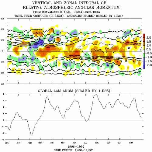
Link to Plot Relative AAM Charts
LakeEffectOH replied to LakeEffectOH's topic in Weather Forecasting and Discussion
CustomWX, Thanks a lot! I'll check out the link. -
Link to Plot Relative AAM Charts
LakeEffectOH replied to LakeEffectOH's topic in Weather Forecasting and Discussion
Does anyone here have an answer? -
Does anyone know a link where I can go to plot the latest Relative AAM chart such as the one attached? Thanks! LEO
-
Pitiful...just pitiful...

-
I sure hope so...this winter is absolutely disgusting. Makes 2001-02, 2011-12 & 2019-20 look good.
-
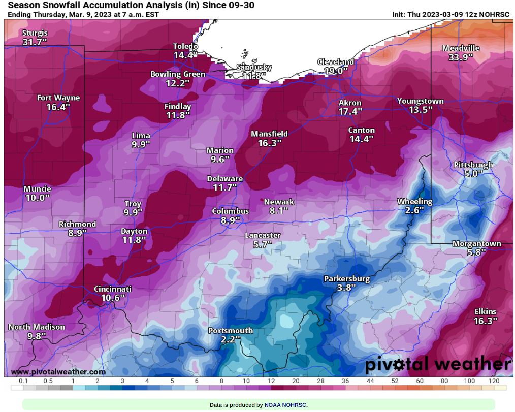
This winter has got to be a record setter for the Snowbelt as far as lack of snowfall goes. Chardon, so far this season, has had just under 40". Ugh! I hope the saying "What a difference a year makes" applies to next winter.
-
My Winter Outlook for 2022-23
LakeEffectOH replied to raindancewx's topic in Weather Forecasting and Discussion
Curious here...does anyone think last year's Hunga Tonga volcanic eruption contributed to pattern disruptions causing this winter's extreme warmth? This eruption blasted a tremendous amount of water vapor into the stratosphere. -
Best of luck for your travels. Be safe and warm.
-
Ok, that makes more sense...
-
In Ashtabula County? That's close...
-
Wind's picked up here. Some little snownadoes now happening.
-
I don't see that weird hole on the 18z HRRR.