

TheClimateChanger
-
Posts
3,506 -
Joined
-
Last visited
Content Type
Profiles
Blogs
Forums
American Weather
Media Demo
Store
Gallery
Posts posted by TheClimateChanger
-
-
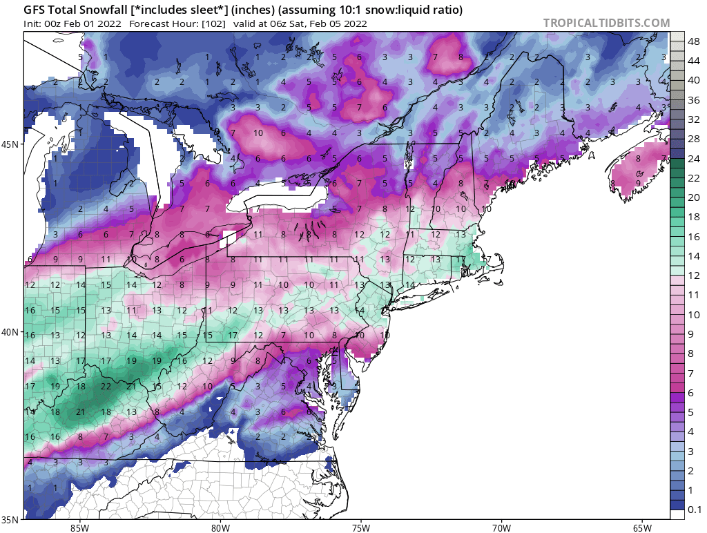
9 minutes ago, RitualOfTheTrout said:
Alright…wtf… who stole the GFS super computer cluster and is running it in their basement with modified physics code?
 It can’t be this different from the rest and be correct can it? Lol
That's a depth positive change map, which includes sleet as snowfall... similar to this one from Pivotal:

-
-
2 minutes ago, KPITSnow said:
I was honestly hoping that it would put this to bed, but it didn't. AMazing how wildly different the NAM and GFS are.
Why are they so different? I think it was hour 72 or somewhere around there... the NAM had Charleston, WV at 55, and the GFS at 32?
-
-
0z GFS (Kuchera ratio):

-
The 0z GFS still looks like a decent hit.
-
Well, alrighty then, better get the generator ready…

-
59 minutes ago, Floydbuster said:
Hmmm. Not bad but hoping for a few inches more. That map gives me about 6-8 inches.
Here's the updated map through Friday morning. Looks reasonable, except there's a strange band across the SE portion where snowfall suddenly jumps 2+" across no more than like 5 miles.
-
Not much snow on the NAM, but it does seem to be trending towards a pretty substantial mixed precipitation event. Shows about 1-2" of sleet or sleet/snow mix in the north, with a band of up to an inch of freezing rain through the metro area.


-
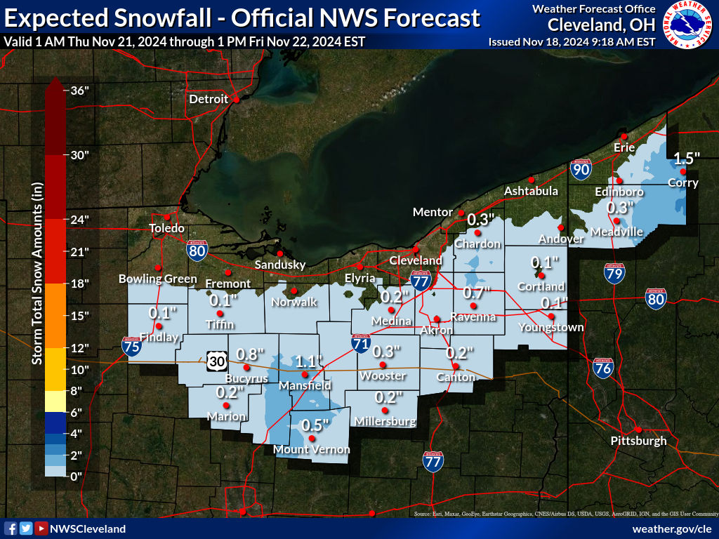
Here's the official NWS forecast through Thursday at 7 PM:
-
-
1 hour ago, Ahoff said:
Would it take into account that most of what we have now will be gone?
Well, it's supposed to account for melting and other effects. But it's only showing a couple inches of change between now and Thursday evening. It does seem to keep temperatures mostly below 40.
-
Uhhh, this doesn't look too good...

-
I like the Canadian snow depth map. This includes snow on the ground now. I'm not sure how these things are generated, as it certainly doesn't really jive with the snowfall maps. But it's fun to look at!

-
Today's 12z run of the UKMET continues to look pretty good for our region. It's been pretty adamant about the further south track.

-
Looks like the NWS isn't expecting much. This is area-wide from the current HWO:
.DAYS TWO THROUGH SEVEN...Tuesday through Sunday.

Widespread and periodic preciptation associated mid to late week
frontal encroachment will result in mixed wintry precipitation which
could need a Winter Weather Advisory.
Looks like they aren't anticipating the need for Winter Storm Watches or Warnings anywhere in the CWA. We get advisories for a trace of freezing drizzle so they aren't going too far out on a limb.
-
6 hours ago, Floydbuster said:
Well with the way all the non-meteorological people are talking on social media and around the water cooler, if we don't get atleast 10+ inches, they'll say it's an over-hyped bust.
I wouldn't get too hung up on the colors. Those snowfall maps with the razor-thin cutoffs are inflating the snowfall relative to the depth change and (incorrectly) excluding sleet accumulations. I mean have you ever seen a (non-lake effect) storm go from 5" in Akron to two feet in Cleveland? Lol.

-
Much better look. At hour 84 (Thursday evening), the NAM is now showing freezing rain for many places north of the city. Still think it's way too amped, I can't see this wave of low pressure just bullying that 1050-1055 mb high pressing south from Canada. Normally, the biggest player is the low pressure system. In this case, however, the strongest feature appears to be that high pressure pushing south from Canada. I would think that arctic high would have a huge say-so in the ultimate track of this storm system.
.thumb.png.da764b580cc4793703595090d2a59080.png)
-
11 minutes ago, KPITSnow said:
Fairly certain this includes sleet. It was like 4-6 inches of snow and 4-6 inches of sleet.
Sleet counts as snowfall in the weather records, so if the snowfall maps are completely excluding sleet they are going to come in too low. Normally, it wouldn't make a big difference as sleet accumulations are typically an inch or less. But the GFS shows several hours of heavy sleet with the snowfall maps (even the 10:1) not detecting any accumulation. If that were to actually occur, then yes, 3, 4, 5 inches of sleet are possible, which are being excluded from the snowfall maps. If you get an inch of QPF to fall as sleet at a 3-5:1 snow to liquid ratio, then that's 3-5 inches of sleet.
-
Nevermind. A big part of the disconnect is your map cuts out substantial snowfall that occurs after 3z Friday. There's still some weirdness going on, but a lot of those places are projected to receive several inches of snow later Thursday night into Friday.
-
4 hours ago, WHEATCENT said:
Gfs extreme totals gone but nice and south
.thumb.png.6112af03e5f03ed646ac5c486f226744.png)
Seems to be a disconnect between the Pivotal snowfall maps and the Pivotal change in snow depth maps. Some areas on the southern edge are projected to have a positive snow depth change of a foot or more, but depicted to receive little if any snowfall.
-
-
-
1 hour ago, Burghblizz said:
Taken literally, I’m like 20 miles from the foot line, but yeah, not a fan of that look.
It never actually plays out like when the snowfall algorithms show those razor thin cutoffs like that in these types of setups. What would probably actually happen is a couple to a few inches of snowfall around the Pittsburgh to like 6, 7, 8, maybe 9 inches of snow around I-80. I suspect a lot of that along the southern edge of the heavy snowfall is actually slop - i.e., mixed sleet and freezing rain. The warm air aloft always makes it further north than expected. So even the 10:1 map is probably inflated.


.png.a22d282d048781d6f4692388a8eecf6d.png)

Western PA/Pittsburgh Winter 2021/22 Discussion
in Upstate New York/Pennsylvania
Posted
I think that's the one missing variable. If we can get that boundary through, then winds shift to the north. With north winds, the typical warm nose is non-existent at least at the surface which would allow any mode of wintry precipitation to occur over plain rain.