

TheClimateChanger
-
Posts
3,506 -
Joined
-
Last visited
Content Type
Profiles
Blogs
Forums
American Weather
Media Demo
Store
Gallery
Posts posted by TheClimateChanger
-
-
This one's coming south, gentlemen. Looks good.

-
1 minute ago, TheClimateChanger said:
Our south ticks are killing the storm. Now looks like a rather pedestrian snow event (7-10 inches) for most of northern Ohio and western New York. Maybe a few lollipops up to a foot in the favored areas with a bit of lake/orographic enhancement.
By the time it trends here, might be under 6" everywhere.

-
Our south ticks are killing the storm. Now looks like a rather pedestrian snow event (7-10 inches) for most of northern Ohio and western New York. Maybe a few lollipops up to a foot in the favored areas with a bit of lake/orographic enhancement.
-
3 minutes ago, TimB84 said:
Euro with a slight tick in the right direction. Maybe not enough, but when is it ever?
I'd say a bit more than a slight tick. Now gets heavier snows (6, 7 inches) into parts of Beaver and Butler Counties. Not quite up to the GFS's totals of around a foot. But certainly increases likelihood of a decent snowfall (5"+) for north and west of the city.
-
 1
1
-
-
Baby steps on the Euro:

-
Unfortunately, the short-term Canadian model still wants to send this storm up to, well, Canada:

-
I don't know, guys. This pesky GFS just doesn't want to budge. Looks like it's going to just keep holding pat until all the other models converge onto its idea.
-
1
-
-
If the sleet were to somehow fall as snow:

-
Not bad. Very subtle slight south shift in highest snow totals. Now brings a foot to most of Beaver and Butler Counties, as well as NW Allegheny.

-
1
-
-
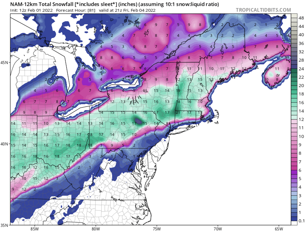
I think we legitimately could get 2-4 inches of sleet, maybe 5 in spots, if these models are correct (probably with some snow mixed in too).
-
Posting this not as a snowfall map, but to show just how much sleet would be possible on the NAM. This map shows all precipitation falling as sleet and snow as 10:1, so that means about 1.8" of precipitation is to fall as snow or sleet - almost all of which falls as sleet. Using a more realistic 3:1 or 4:1 ratio for sleet would mean 5.4-7.2" of sleet...

-
1
-
-
2 minutes ago, KPITSnow said:
Ok that makes more sense.
Yeah, sleet is like 3:1, maybe 4:1. Would take a full inch of precipitation to lay down 3" of sleet. I will say normally when we get sleet, there is at least some mangled snowflakes mixed in. And perhaps the occasional changeover to heavy, wet snow with dynamic cooling of the column during periods of heavier precipitation. So we could get a bit more accumulation than the models are showing. It seems the Pivotal algorithms are set up to completely discard mixed precipitation as snowfall, which is why it keeps showing the razor sharp cutoff from 12+ to little or nothing.
-
1 minute ago, TimB84 said:
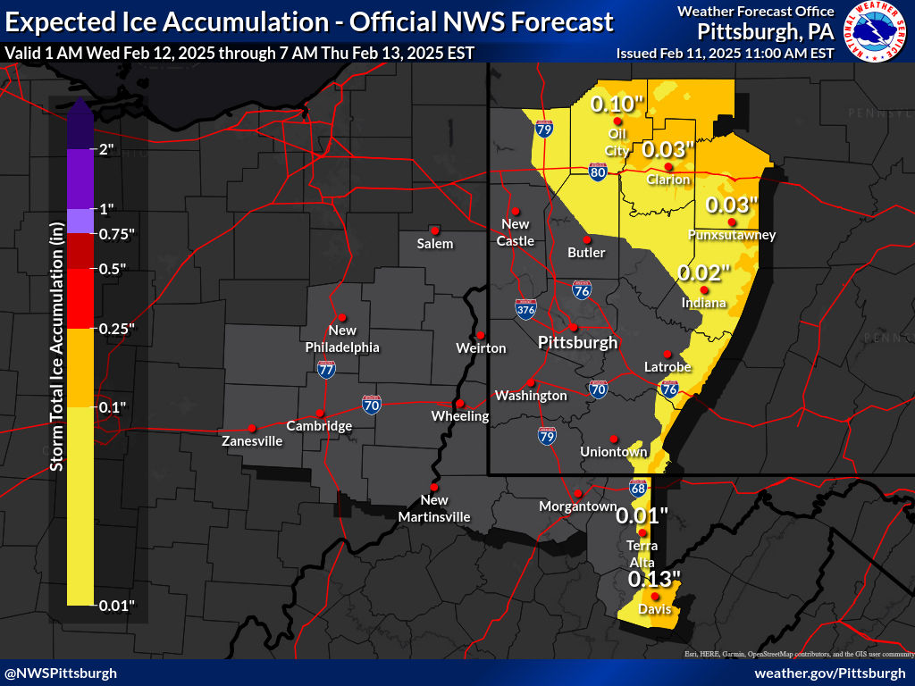
0.25”+ is red. I don’t see any red on that map.
Sorry, I edited my reply. I was still viewing the old map. Refreshed to the new one when I posted.
My edit:
Actually they just changed it. I was wrong. Now they show generally less than a tenth of inch of icing. I had to refresh my browser for the new map.
-
3 minutes ago, TimB84 said:
That’s significantly less bullish than they were on the ice potential earlier. The previous package had over a quarter inch for much of the metro.
Actually they just changed it. I was wrong. Now they show generally less than a tenth of inch of icing. I had to refresh my browser for the new map.
-
1
-
-
3 minutes ago, TheClimateChanger said:
It looks like the NWS updated the expected snowfall map. Looks like totals have been bumped up a bit. I think it looks pretty reasonable at the moment. The 2.3 inch amount is for downtown Pittsburgh. The airport would be closer to the 3" line - probably checking in about 2.8 or 2.9 taking this forecast literally. I'd say it looks good, but I might place the initial over/under value for the airport closer to 4". The NWS is also forecasting the potential for 0.2-0.3" of ice through much of the area.
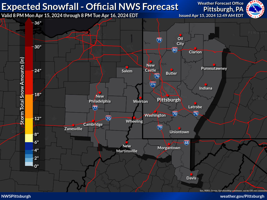
Really I think with the current trends, we could see all zones get bumped up one tier. Might be more in line with a blend of the NAM/GFS at this point. Would also coordinate better with the snowfall map from NWS CLE which has 6-8 in the southern counties.
-
It looks like the NWS updated the expected snowfall map. Looks like totals have been bumped up a bit. I think it looks pretty reasonable at the moment. The 2.3 inch amount is for downtown Pittsburgh. The airport would be closer to the 3" line - probably checking in about 2.8 or 2.9 taking this forecast literally. I'd say it looks good, but I might place the initial over/under value for the airport closer to 4". The NWS is also forecasting the potential for 0.2-0.3" of ice through much of the area.
-
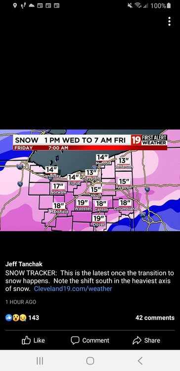
I saw this in the Ohio thread from a TV meteorologist in Cleveland. Brings a foot and a half of snow all the way to the Ohio River in eastern Ohio... what model is showing that? I thought this might raise spirits here though. Lol.
-
I don't really understand why the forecast still has mid and upper 30s on Thursday? Even the warmer NAM has temps below freezing by daybreak, and drops it into the upper 20s during the afternoon Thursday. GFS shows mid 20s Thursday afternoon. If temps are 25-28F, that also calls into question the theory that the ice won't accumulate much at 31F, no?
-
Probably too late in the game to get to Pittsburgh, but it is now starting to show heavy snow in parts of the NWS office's CWA. Even the much warmer NAM now brings 8-12"+ to Mercer, Venango, and Forest Counties. Far cry from the 3-6" in the WSW. Might be able to get those higher totals to come down another row of counties further south though.
-
This is one case where the maps that include sleet accumulation are probably more realistic, rather than a sudden decrease from 12" of snow to 0" of snow.


-
It does try to nose the warmth back up, which pushes the sleet back over Pittsburgh. At 21Z Thursday, its 30F at PIT (versus 31F on the prior run), but Charleston, WV is 10 degrees colder at the same time than the prior run (40F versus 50F).
-
Oh yeah, it is. Big time. Mix line down near Greene/Washington County border - and this is only early afternoon Thursday!
-
NAM caving? I haven't even looked at the sensible weather yet, but the 2M temperature at 15Z on Thursday (what is that about 1 PM, I think?) in Pittsburgh is now shown on the 12z run as 27F in Pittsburgh versus 31F at the same time on the 6z run.
-
4 minutes ago, Floydbuster said:
Woah. That's all of the state being pounded by high accumulations.
Well, this particular map does include sleet so it’s inflated somewhat due to that in the south. But I liked it because it looks impressive and really screws over the typical north and west crowd.
-
2
-
 1
1
-
 1
1
-
Western PA/Pittsburgh Winter 2021/22 Discussion
in Upstate New York/Pennsylvania
Posted
Yeah, you are right. And it's not exactly dry. Still shows 2" of total precipitation nosing into western Allegheny, with a widespread 1.3-1.8" for all of northern Ohio. I'm actually a little bit surprised the snow map is as paltry as it is for those areas (even at 10:1). Must be a bit more mixed precipitation up that way versus the GFS solution.