jwilson
-
Posts
1,292 -
Joined
-
Last visited
Content Type
Profiles
Blogs
Forums
American Weather
Media Demo
Store
Gallery
Everything posted by jwilson
-
Pittsburgh, Pa Winter 2023-24 Thread.
jwilson replied to meatwad's topic in Upstate New York/Pennsylvania
I think we had more storms over the last couple days than we did all of last summer. -
Pittsburgh, Pa Winter 2023-24 Thread.
jwilson replied to meatwad's topic in Upstate New York/Pennsylvania
Not much winter to forecast. The ensembles all show a warmer pattern after this coming weekend when we get a cold shot, but it looks like any snow talks are on hold for a while. The GEFS is the exception for now which shows a little possible something on March 2nd when we get a transient ridge in a near ideal position. But it is on its own. The EPS and GEPS are both showing a strong warm look, nearly full latitude ridge at that time. I guess if you roll the pattern forward, mid-March is a possibility for something? Hard to get overly excited at this point. March is always a wild card, of course, but for me it's something historical like 1993 or let's just move on to spring. Five-and-dimes aren't as effective or interesting after February. In December? Sure. -
Pittsburgh, Pa Winter 2023-24 Thread.
jwilson replied to meatwad's topic in Upstate New York/Pennsylvania
I drove through that death band in the city. 279 from the north was completely covered and I passed one vehicle that had clearly spun around. It was snowing so hard snow was accumulating on my hood while I was driving. Massive dinner plate flakes. Once I got beyond the Liberty tunnel you could see the subsidence. Much worse dendrite growth and 19 in the South Hills was mostly just wet, excepting a few spots. The snow started getting a bit heavier in Bethel beyond Mt. Lebo. -
Pittsburgh, Pa Winter 2023-24 Thread.
jwilson replied to meatwad's topic in Upstate New York/Pennsylvania
NWS pretty bullish on their call. There is going to be a narrow band of winners somewhere between Allegheny and Morgantown. Problem is if you're outside that maxima band, you're probably dealing with subsidence and bad dendrite growth. Pretty much all the latest mesos keep that band in Greene and Washington counties. It will be interesting to nowcast that and see where it falls. I thought the soundings weren't that great looking into Allegheny even yesterday in terms of maximizing potential, but I don't know how reliable those are from the mesos. -
Pittsburgh, Pa Winter 2023-24 Thread.
jwilson replied to meatwad's topic in Upstate New York/Pennsylvania
On all the ensembles, there's another Omega block look setting up for next weekend, except with the ridge potentially positioned further west. I had highlighted this period in the past because the ensembles had pretty classic East Coast snowstorm looks before. Now that look is not at all the same, but it could still setup into something interesting. The operationals show nothing but that's irrelevant right now. Remember that the last time that omega block happened, we had a pretty major storm, it just missed us by a few hundred miles and buried other places in feet of snow. It's quite possible this is our last chance before March torches, so I'm going to enjoy tracking this even if it amounts to nothing. -
Congrats on the win! We went from rain to snow to heavy snow to mix to flurries to high clouds in the matter of 48 hours out here in Pittsburgh. I'd ask my mom to measure (Hatboro), but I'd prefer she doesn't slip in the conditions.
-
I was obsessed with the original when I was 10 - went to see it in the theater at least three times and then burned through a VHS copy. A big reason I got into tornadoes and weather was because of that movie. Obviously the science doesn't hold up at all, and I imagine this sequel won't be any better in that regard, but it's a trip.
-
Pittsburgh, Pa Winter 2023-24 Thread.
jwilson replied to meatwad's topic in Upstate New York/Pennsylvania
It does depend a bit on which model you followed. The Canadian and Ukie both picked up on the southern solution earlier, starting Thursday into Friday. Thursday at 0Z was the last run the CMC showed a really amped northern push. The problem is forecasters, myself included, don't put as much stock in those compared to the GFS and Euro, and those two were still showing a bigger spread into Sunday. It's a bad performance, but the GFS has been quite bad this winter, overall. There's always those occasions where certain models score an unexpected win. Back in 2016, for example, even the NAM scored a win, and that's quite rare. -
Pittsburgh, Pa Winter 2023-24 Thread.
jwilson replied to meatwad's topic in Upstate New York/Pennsylvania
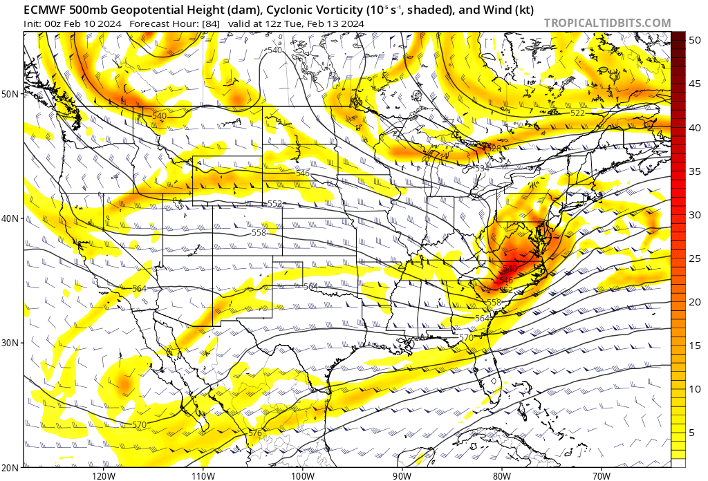
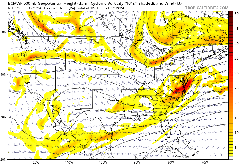
Yep, really a function in the change of the confluence up north. This is from 0Z Saturday when it looked like the storm could have driven north of us. Here you can see the northern stream is pretty flat and not particularly intense (area across Northern Michigan and Wisconsin), while our s/w of relevance is relatively spread and unaffected. And then this is 12Z today. Suddenly you have a bit of a notch developing in the wavelengths (stronger confluence), and it's also pressing down more with less of a West to East, flat orientation. It's exerting more influence, overall. Our area of relevance is more compressed, too, because of those NS changes. Most of the energy is confined to a SE quadrant. Precip shield cannot extend further to the NW away from that vorticity. Manipulating a system like this creates your intense and compact deformation bands, but it limits the AOI of the storm. Enough to generate those crazy gradients. I think part of the problem lately is that NS moving so fast anymore and with it constantly dropping s/w after s/w, we're having more trouble timing things properly. It feels like our only hope is to get the NS to phase in and give us something bigger while hoping we have some kind of block in place to prevent a storm from progressing north unimpeded. It seems we can't just run a developed southern stream event without interference. This is something more akin to Nina behavior, too.

-
Pittsburgh, Pa Winter 2023-24 Thread.
jwilson replied to meatwad's topic in Upstate New York/Pennsylvania
I think this winter has proven to be a humbling experience thus far for weather-oriented folks. Every time you think you're learning and understanding something, the atmosphere turns around and says, "Nah, bro," and kicks you in the nards like a middle school bully. Our understanding of atmospheric physics is clearly still in the novice stage, about as deep as a kiddie pool (relatively speaking). The fact that models continue to struggle this bad is evidence of that. Our weather likely being heavily influenced by things happening in or around the Indian Ocean is the perfect illustration as to why we don't have a firm predictive grasp on global weather patterns. It's the butterfly effect. It's looking more possible the groundhog was right and we can forget this winter happened before too long. -
Pittsburgh, Pa Winter 2023-24 Thread.
jwilson replied to meatwad's topic in Upstate New York/Pennsylvania
On the bright side, at least it was relatively easy to avoid investment into this storm. Long range it looked like a cutter, then it got borderline for 48 hours but never really looked right, to suppressed mode in another 12 hours. -
Pittsburgh, Pa Winter 2023-24 Thread.
jwilson replied to meatwad's topic in Upstate New York/Pennsylvania
The latest convergence we see is actually between the Euro, Canadian, and Ukie with a lower northern component (almost a non-event now) and more of an eastern component, which probably makes more sense if you think about. Consider the southern solutions from before were modeled that way because of stronger and faster confluence coming out of the NS. This is acting as a kicker and preventing much deepening or negative-tilt prior to the storm advancing out to sea. That likely puts the better CCB/deformation banding to areas east of us. I basically ignored the idea that the CMC and Ukie could be right and figured the Euro and GFS combined were a safer duo. That's a whoopsie, and if the former score a coup on this storm, I think I'm done predicting or analyzing anything this winter. Considering how much things have changed in 24 hours, it's difficult to say anything is finalized now, but there appears to be a bit more agreement as compared to 12Z yesterday. We're still dealing with a marginal airmass and bad surface thermals. This is evidenced by the fact that we have an ideal vort pass on all three levels (south of us), but we're still struggling to generate snowfall. If the storm is kicked east quicker, that part aligns, because the deepening which generates the cold air we need occurs out of our zone. The GFS is sort of on its own again, but it jumped south significantly between 12Z and 18Z. Oil City went from 15" to 3" in one run. That could very well mean it is beginning to fall in line with the other guidance. Another 24 hours will tell the tale. -
Pittsburgh, Pa Winter 2023-24 Thread.
jwilson replied to meatwad's topic in Upstate New York/Pennsylvania
The CMC is the only one of the majors that keeps it an open wave, meaning the lows - at all levels - never close off. So the s/w doesn't deepen and it bounces along the confluence out to sea. It's subtle, but it is also a tad bit stronger and further south / faster with the confluence. There's a suppressive element to that difference. There's not a ton of NS energy getting phased into the center in any case. The good and bad of that is we have a cap on how far north it can realistically go, but it also means we cap how deep the storm can intensify. Most of that energy acts more of a kicker to knock the system East, which also means the center of LP stays farther away and limits its influence on us. Obviously, we're coming into this event with extremely marginal cold air. It's going to be 50 degrees Monday. In a system like this, that doesn't matter quite as much, but the antecedent thermals are always relevant to some extent. Both the Euro and GFS are now keeping the better totals north of PIT metro. Based on experience, I think I see enough red flags to bail on this one, at least here in the South Hills. I'll be happy if I'm wrong, but I would honestly be quite shocked to see this one come back south and bullseye the Pittsburgh localities. That would go against conventional wisdom. Not saying it's impossible, but I'm playing the odds here - if you're into betting, it's like taking the favored home team. -
Pittsburgh, Pa Winter 2023-24 Thread.
jwilson replied to meatwad's topic in Upstate New York/Pennsylvania
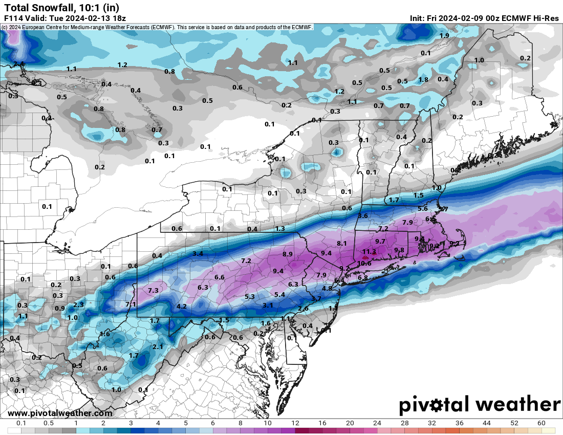
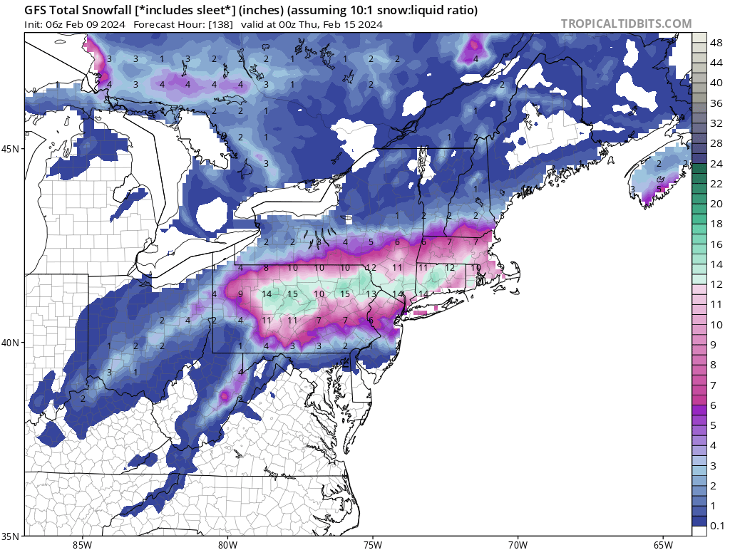
I wasn't buying into the GFS solution because it didn't have any support before now. The 0Z Euro managed to pop a mini jackpot over Allegheny County. We're threading the needle, but if you want a possible snow solution, the Euro - at least temporarily - backed off the cutter idea. If that holds at 12Z I'll be slightly more interested. You can see the potential thermal issues, however. The GFS warm tongues us and although the heaviest swath of snow is generally in the same area, it extends a tad further north. It's a delicate setup, to be sure.

-
Pittsburgh, Pa Winter 2023-24 Thread.
jwilson replied to meatwad's topic in Upstate New York/Pennsylvania
The storm around Valentine's Day was what I expected to be our initial cutter that helped set the pattern going forward. Others have already said it, but if we want that one to be snow, we need perfect timing of the phase. I don't generally like betting on those types of storms because of all the ways they can fall apart. That doesn't mean it can't happen, however. If it does miss, I don't think it's a big deal in the grand scheme of things. If we get a hit, that's a massive bonus. The question is what happens after, because right now the OP models are sort of kicking the idea of an established -NAO. The ensembles still seem to have it in the long range, but it's not developing in the same way it was before. If you go back in time, you can see the ensembles started establishing the -NAO around the 17th after the bowling ball shortwave resets the table. The latest runs push it to the 20th and it's a retrograded Scandinavian block instead. Maybe this is delayed instead of cancelled, but it's enough to raise an eyebrow. The OP GFS isn't showing a -NAO at all, even in fantasy land. Now the GFS has been particularly bad this year, but the Euro and Canadian only give a faint appearance at the very end of their latest respective runs. We're going to have to wait a bit longer for resolution. Now that's all "meta" pattern talk and not necessarily relevant to the individual storm threats we may face. Right now, the President's Day threat looks like a classic Miller A, but it's fairly basic overrunning wave that gets squashed by the NS plunge. There's zero interaction between the two streams. Verbatim that event has a capped ceiling. It's northward progression is dependent upon timing and strength of the cold boundary. Unfortunately, you have those two lower pressures sinking at the same time, with the energy in the southwest shrinking away from the NS, instead of say a basic western ridge that forces the NS energy down into the CONUS. In the north, it's a classic Rex Block. That stalls that cold air bubble a bit longer rather than allowing it to make West-East progress and get out of the way. What I'm perhaps most interested in, for now anyway, is what happens after the PD event. It looks wonky in the interim, but it won't resolve that way and ultimately doesn't matter quite yet. If you freeze the 12Z OP GFS at 300 and overlay with the ensembles, you can see the potential. I do think it's also possible, however, we end up kicking a better established pattern into March. And I hate to phrase it that way but this is the danger of long-term tracking. The good news for now, even if that happens, we have threats to watch. -
Pittsburgh, Pa Winter 2023-24 Thread.
jwilson replied to meatwad's topic in Upstate New York/Pennsylvania
I agree with you here. This isn't the character of a winter with a longer term sustained cold regime, really. I suppose we could have something that spurs such an event, like one of the teleconnections goes off on a wild tangent at a significant magnitude and alters the character. I would suspect the -NAO block isn't stable for a significant period. Right now I would favor 70/30 odds of a two-week ceiling like we had earlier, meaning 70% chance the block breaks down faster than expected. The longer-term looks on ensembles could simply be due to the smoothed mean. The real trepidation for us here is the entrenched block suppressing the big fish to our south or off the coast and the precip shield misses us. Most likely what's hurt Pittsburgh in previous Nino conditioned winters. Those blocks can often move the boundary beneath us. The saving grace is the time of year, perhaps, in that it is happening in late February / early March as opposed to earlier in winter. Then again, the groundhog told us we'd be in for an early spring. That should guarantee sustained winter through March. -
Pittsburgh, Pa Winter 2023-24 Thread.
jwilson replied to meatwad's topic in Upstate New York/Pennsylvania
Thus far, it is the warmest winter in modern or recent history. The only dates beating it are from 1890, 1932, and 1880, so for me that data is incongruous and largely irrelevant. The other contemporary date in the Top-10 is from last year, unsurprisingly. -
Pittsburgh, Pa Winter 2023-24 Thread.
jwilson replied to meatwad's topic in Upstate New York/Pennsylvania
We're still really a week to 10 days out from determining the extent of the pattern change. By that point, we'll be much closer to the transition period to see if things still progress as long-range guidance implies. Ensembles haven't budged much. The mid-week Omega Block didn't work out because we basically have a double-ridge that moved too far to the East, which blocks the trough out into the western Atlantic. Sort of a trend this year - we can't get the boundary interaction and timing exactly where we want it. We'll have to deal with at least one cutter, I would think, before the shift in the block and jets. Right now it's just a waiting game. -
Pittsburgh, Pa Winter 2023-24 Thread.
jwilson replied to meatwad's topic in Upstate New York/Pennsylvania
I'm repeating myself a bit here, but my expectations for this winter were set at 30" based on historical analogs. That was basically the ceiling for Pittsburgh during +2.0 Nino events (we peaked at +1.9, I think, but that's hair-splitting). It's a below average winter for us, by far, but since my expectations were relatively low, I'm not too surprised by how things have gone. My only inkling was that maybe we'd hit a big storm this year - and that would essentially be the source of most of our season's snowfall. I'm generally fine with such an outcome. The eight years it has been since a 20" storm is the longest I've gone in my life not seeing something of that magnitude. It's obvious by now that this wasn't going to be a wall-to-wall winter with infinite opportunities. I guess chances might favor we get a repeat of January with a 14-day threat window where cold and precipitation align. Like you, I don't necessarily care as much once we get into March, but March is quite capable of producing big winter events. Just two years ago Pittsburgh got >17" in March, but someone will have to fill in the blanks for me because I don't remember how that happened (2022 was a weird year for me). Pittsburgh's biggest storm ever was in March, of course, but I guess since that was such a fluke thing it's mostly irrelevant. Only point being that even if we end up moving the window later in February or back into March, there's still chances to be had. Our window is open a bit longer than places south and east. -
Pittsburgh, Pa Winter 2023-24 Thread.
jwilson replied to meatwad's topic in Upstate New York/Pennsylvania
I think anything we might score in terms of snowfall before Valentine's Day would be considered a bonus given the overall pattern. There's an interesting Omega Block setting up around the 7th that's worth keeping an eye on as long as it stays. Getting the requisite cold is going to require an anomalous low, in all likelihood (meaning something really wrapped up). Big issues right now are +EPO, +AO, and +NAO keeping the cold out of North America. The MJO is supposedly dying in Phase 7 which isn't ideal, but that's the lesser of the problems. The velocity of the pattern change is what remains our big question. Do we get sufficient movement by President's Day? Late February is one of those odd times where big storms seem much less common, then March becomes the coin-flip month. -
Pittsburgh/Western PA Banter & Complaint Thread
jwilson replied to blackngoldrules's topic in Upstate New York/Pennsylvania
Pittsburgh's 20-year average (45.60) is up slightly over the 30-year average (43.04), but the average is actually down below that 30-year number if you don't include 2010, which remains a pretty high outlier. I realize this is "cheating" to some degree. I don't put much stock in older climate numbers, either. Stuff from the 1890s and early 20th century is so unreliable, and it isn't an apples-to-apples comparison to our modern data collection methods. I realize they use it because they have it, and we're dealing with a relatively minute dataset as it is even including those years. It's just a grain of salt interpretation for me. Even the more recent 30-year average is such small sample size relative to all our climate history. It's almost impossible to know the extent to which things are changing in terms of snowfall amounts and so forth. There's a few things we do know, which is disruption of the northern jet because of a warming pole, melting sea ice, etc. We've been stuck in a longer-term Nina-like base state and -PDO, but I don't know if that's related to climate change or merely cyclical, or perhaps both. That disruption of the northern jet is likely why we haven't experienced as many clippers of late - the jet often dips south of us or is off-kilter from our latitude. It's not as consistent anymore. That's my theory, anyway. Also why textbook Miller As are less common (and a lack of Ninos). The other clear change is SSTs and how much warmer the ocean is, which is partly why the coastal plain has struggled for snow lately. Although the warmer oceans worldwide disrupt our weather patterns more esoterically, the local Atlantic temps create opportunity for bombogenesis-type events with increased frequency. This is where you perhaps get into a feast-or-famine pattern that means big storm and snow or anything smaller is rain. The ocean is less geographically relevant for us, of course. -
Pittsburgh, Pa Winter 2023-24 Thread.
jwilson replied to meatwad's topic in Upstate New York/Pennsylvania
This would be a complete fluke storm if there ever was one. Hostile pattern mostly, minus the western ridge in a good location. But as you said, the cold is scoured out of NA by that +EPO. We'd have to time this right underneath the rotation of the TPV lobe over Hudson Bay and dig a s/w deep enough to produce its own cold sector. The ensembles look better because they have a stronger lobe that reaches a bit further south. Makes enough changes to the eastern trough. If the s/w comes in a bit later behind the lobe and still amplifies, it cuts west of us, and there's nothing to stop northern progression. -
Pittsburgh, Pa Winter 2023-24 Thread.
jwilson replied to meatwad's topic in Upstate New York/Pennsylvania
I measured 2.6" before any bands might come through. -
Pittsburgh, Pa Winter 2023-24 Thread.
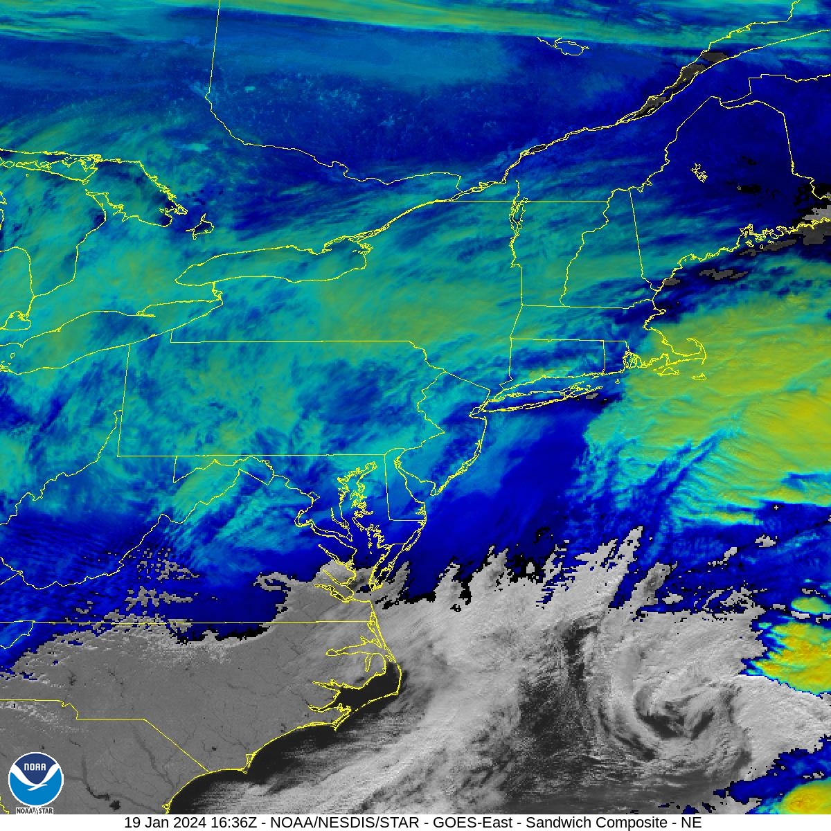
jwilson replied to meatwad's topic in Upstate New York/Pennsylvania
You can see the center of that coastal circulation well off the North Carolina coast (and moving due East). You can also see the flat confluence up in Quebec and how we don't have much lift across the region (low cloud tops). What we had today was the result of separation between two pieces of NS energy. They never got their act together as a team. They stayed separate and we were basically stuck in an area of general "subsidence" (basically between two more organized areas of convection). Think what happens when you're on the edge of one of those intense convective bands of snow. If you're under the band you're getting great rates, but if you're immediately outside the band, it's mostly dry. The air is flowing downward instead of upward. That's what happened on a macro-level, more or less. We experienced the weaker region of lift, but we'll still hit our snowfall targets because of the higher ratios and light winds aloft. It's lower-end, sure, but still within the margins.
-
Pittsburgh, Pa Winter 2023-24 Thread.
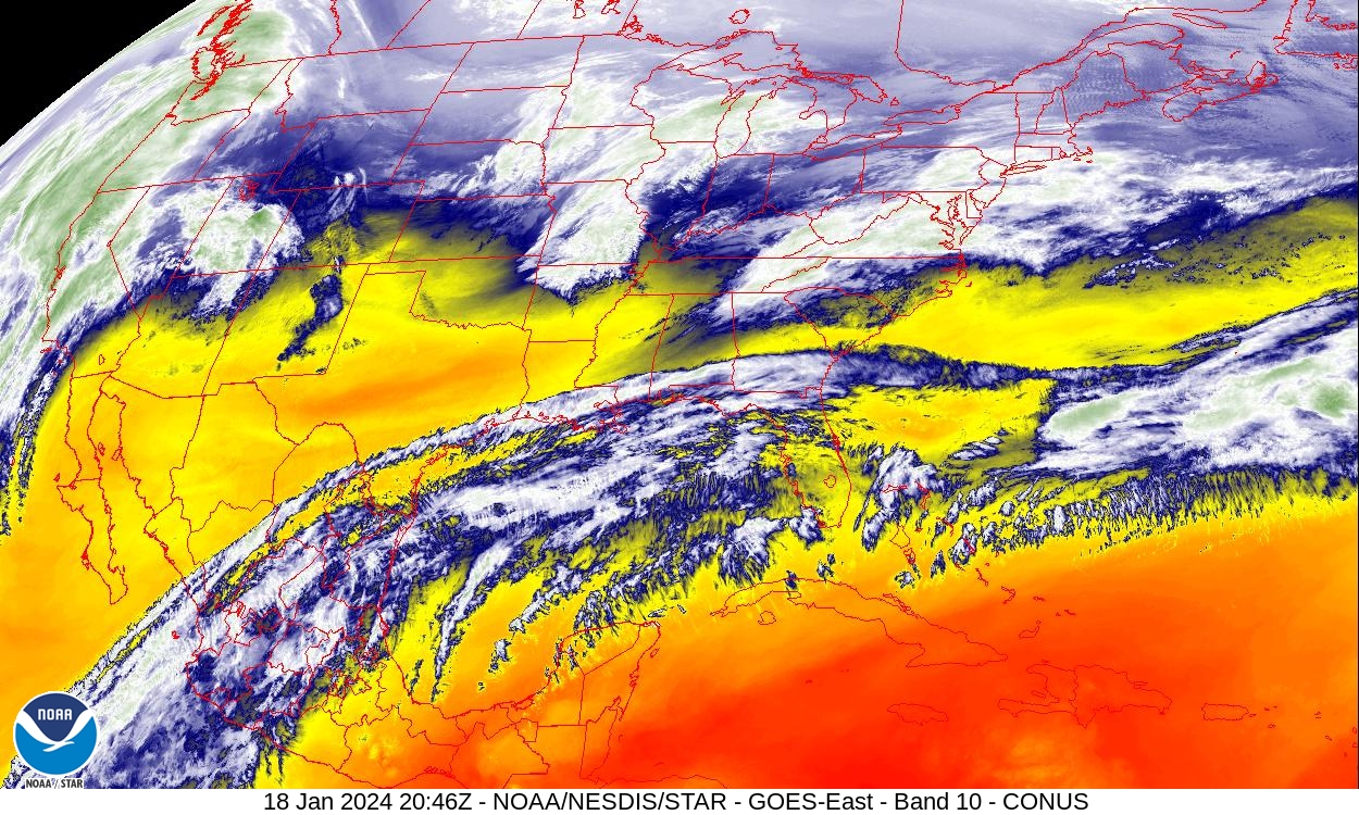
jwilson replied to meatwad's topic in Upstate New York/Pennsylvania
There's a bit of dry air in between the s/w's, but you can really see the separation of the jet steams in this shot. Too bad because we would have quite the moisture pool to tap into down there.