jwilson
-
Posts
1,294 -
Joined
-
Last visited
Content Type
Profiles
Blogs
Forums
American Weather
Media Demo
Store
Gallery
Everything posted by jwilson
-
Pittsburgh, Pa Winter 2023-24 Thread.
jwilson replied to meatwad's topic in Upstate New York/Pennsylvania
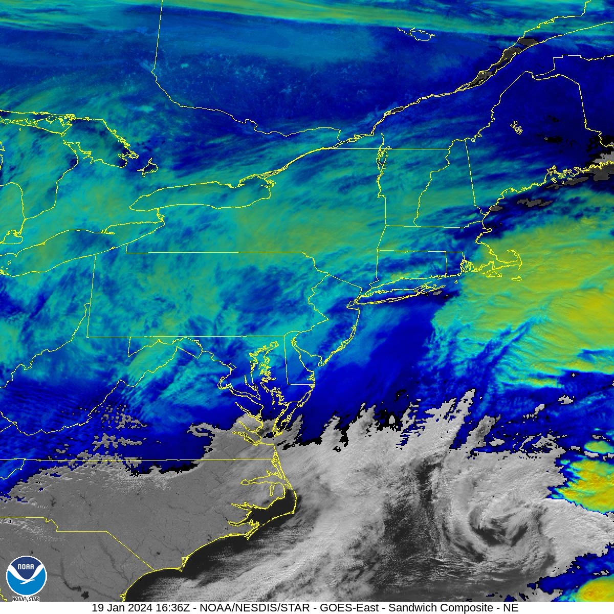
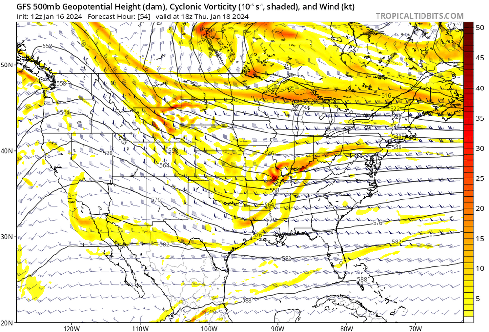
You can see the center of that coastal circulation well off the North Carolina coast (and moving due East). You can also see the flat confluence up in Quebec and how we don't have much lift across the region (low cloud tops). What we had today was the result of separation between two pieces of NS energy. They never got their act together as a team. They stayed separate and we were basically stuck in an area of general "subsidence" (basically between two more organized areas of convection). Think what happens when you're on the edge of one of those intense convective bands of snow. If you're under the band you're getting great rates, but if you're immediately outside the band, it's mostly dry. The air is flowing downward instead of upward. That's what happened on a macro-level, more or less. We experienced the weaker region of lift, but we'll still hit our snowfall targets because of the higher ratios and light winds aloft. It's lower-end, sure, but still within the margins.
-
Pittsburgh, Pa Winter 2023-24 Thread.
jwilson replied to meatwad's topic in Upstate New York/Pennsylvania
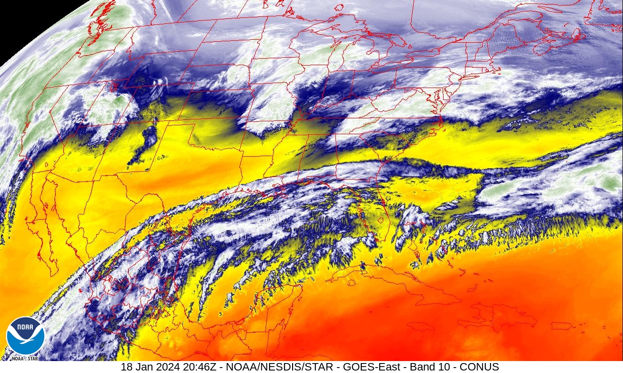
There's a bit of dry air in between the s/w's, but you can really see the separation of the jet steams in this shot. Too bad because we would have quite the moisture pool to tap into down there.
-
Pittsburgh, Pa Winter 2023-24 Thread.
jwilson replied to meatwad's topic in Upstate New York/Pennsylvania
2-6" seems like the appropriate call. If we pick up about 0.20" of precipitation, at 10:1 that's 2", but with temps in the low 20s we could go anywhere from 15-to-20:1 (loosely and disregarding dendrite growth analysis). Probably nothing higher than that. There's no frontogenesis or dynamics associated with redevelopment. This is a slightly juicier clipper. More of a duration and shield-dependent event. -
Pittsburgh, Pa Winter 2023-24 Thread.
jwilson replied to meatwad's topic in Upstate New York/Pennsylvania
Mesos trending to strengthen the primary and squash the secondary. If we wanted a maxima result, we'd want the secondary to develop, tuck, and throw the CCB back across us. As it is now, it looks more like a traditional clipper. Makes sense given the lateral flow. The NBM juiced our totals over the last run to almost 4" average (with >2" at high probably of 91%), up from the 2.7" the previous run. Next update is 19 UTC so worth watching which way that moves considering the latest mesos. A disagreement, of sorts? SREF mean is at 2.7" (ironically) and GEFS average is irrelevant, unfortunately, because the computer is down. Last plumes were from 0Z 1/16. I just realized as I was typing this because they were oddly high. -
Pittsburgh, Pa Winter 2023-24 Thread.
jwilson replied to meatwad's topic in Upstate New York/Pennsylvania
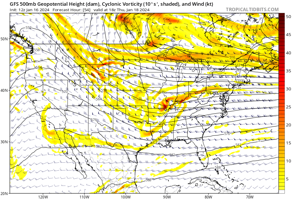
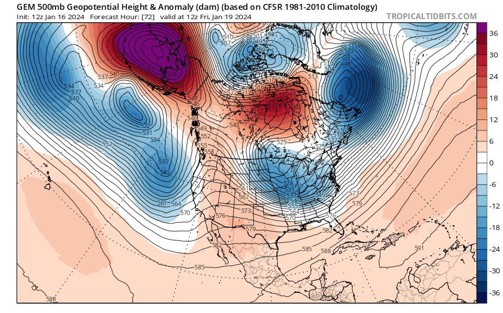
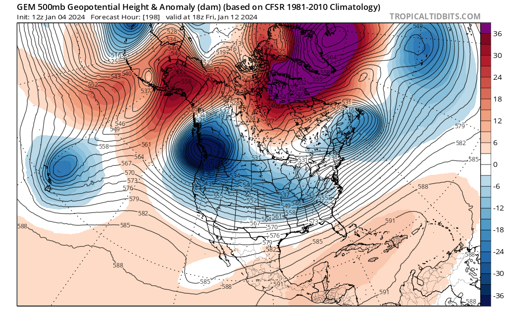
In terms of high-end potential, I don't love the setup for the next system. This was the original window to go KU hunting, but we don't quite have the ingredients in place for one anymore. Here's one example as to why: This shot from the Euro generally depicts the separation of the northern and southern jets. We can see the orientation of the NS (northern stream) basically shunting the SS (southern stream), scraping across the northern Gulf. Here we can see the individual pieces of energy on the GFS. The main bits are south of St. Louis and then back around Eastern Wyoming. That NS/western piece is acting more as a kicker to the SS/eastern piece (which isn't technically part of the SS I suppose, but I'm calling it that for the sake of this discussion). Once again, we aren't timing it right. You can also see the relatively flat, suppressive flow across the East Coast. Basically, that means there's no room for a system to dig and advance north/northeast up the Eastern Seaboard. Anything that develops in the Atlantic gets pushed due East and out of the way. We have a nearby 50/50 that's not in a totally terrible place, but the lack of a timed phase ruin any potential block. The Western ridge axis is pretty well located, but we can see there's no real trough development out East. In this case, we'd probably prefer a steeper ridge. The Canadian looks a little different, a little more amped because the spacing between the 50/50 area low and the TPV lobe allows for heights to raise slightly in the East and a slightly steeper ridge out west. This slows down the SS vort, which allows the NS energy to catch up and they begin an earlier phase, furthering allow a bit more northward advancement up the coast. The Canadian gives a more classic "tucked low" look while the other models sort of wash it out due to the flat flow. The Canadian additionally closes off the 700 and 850mb lows not too far southeast of Nantucket. Neither the GFS nor the Euro ever close these off totally. There's also a slight difference between the Euro and GFS in that the Euro closes off the H500 low about 9 hours earlier than the GFS. It's a slight difference in speed and strength. The coastal development itself is ultimately more relevant for the Coastal plain in this case. We aren't all that far out from this event so I question exactly how much can change. However, without delving too deep into the physics, I suppose it's still technically possible we could either speed up the NS energy, slow down the SS energy, raise the Western ridge a bit more north/make it steeper, and/or create some more jet involvement and phase the storm earlier. Anything like that would lead to a potentially bigger outcome.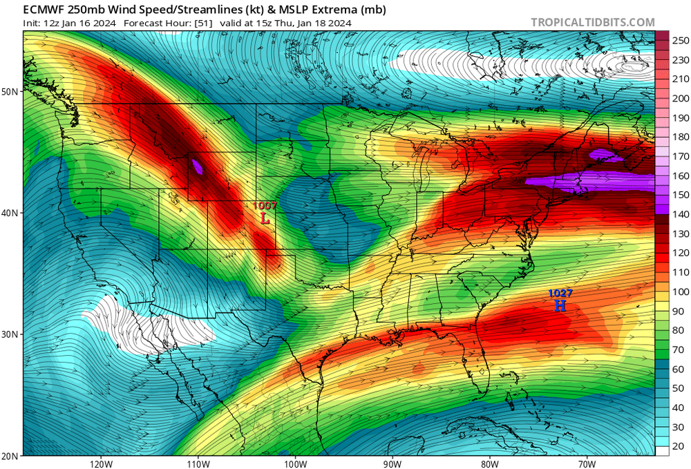
-
Pittsburgh, Pa Winter 2023-24 Thread.
jwilson replied to meatwad's topic in Upstate New York/Pennsylvania
I'm a little surprised at how dry so many of the mesoscale models are, basically amounting to a disorganized, strung-out mess of a system that barely qualifies as a s/w. I guess the old adage that "too cold to snow" remains true. Couldn't quite get the timing right. As others have said, though, snow growth will determine our final outcome. It should have the appropriate fluff factor, just looks like dry air and the energy separation is our problem. Yeah that's the concern. To be honest, my ceiling on this winter was 30" given historical analogs and similarities, but to find a relatively strong snowfall producing pattern and not manage something even moderately sized would be underwhelming, to say the least. January is usually our best month, too. We may be relying on February to get anywhere close to even low-end historical predicates. -
Pittsburgh, Pa Winter 2023-24 Thread.
jwilson replied to meatwad's topic in Upstate New York/Pennsylvania
One could argue next weekend always had more potential, but it's a little disappointing the energy isn't more consolidated for Tuesday, at least not right now. I think there remains a chance it could overperform or surprise us to some degree. It's going to be extra frustrating if we get out of this week without a bigger phased solution considering we watched two massive storms impact the Central U.S., however. We'll regulate over the last week of January, too, so it's sort of a kick to the groin. February will presumably offer more chances, and I suppose less blocking might be better for us inland folks. The break will be welcome either way (busting out and/or after tracking all these threats). -
Pittsburgh, Pa Winter 2023-24 Thread.
jwilson replied to meatwad's topic in Upstate New York/Pennsylvania
It's ironic that the GFS and Euro have completely flipped positions. The Euro went from amped Appalachian spine runner to suppressed, and the GFS went from suppressed to phaser coastal. The Canadian is much closer to the GFS. The Euro hangs back this fairly large piece of energy into southern B.C. It eventually becomes the dominant piece of energy but stays lagged behind the SS and doesn't even drop down. It rotates around the TPV in the NS and washes out before popping much later. Going back, it looks it's because the GFS raises heights in that NW Canada area and cleans out an LP, some of which disappears, some phases into a low over Russia. The Canadian and Euro both hold a piece of that energy and drop it into NA and strengthen it. The GFS has continually weakened that piece. The Canadian just did weaken it significantly between 0Z and 12Z. The Euro has, unsurprisingly, strengthened it. This could be the key cog in the entire mechanism. How that piece of energy resolves, if it exists at all, etc. We'll have to see once the cutter completes its cycle this weekend. -
Pittsburgh, Pa Winter 2023-24 Thread.
jwilson replied to meatwad's topic in Upstate New York/Pennsylvania
Agree now. We're starting to see some signs as to how that wave on Monday/Tuesday can be suppressed. The confluence is trending in flatter, and the energy on the 12Z Euro and 18Z GFS are more separated / disjointed. How can we win? Well, we need that initial southern wave to outrun the confluence and get ahead of it, which to me seems less likely, or we need the energy to really consolidate and fully phase, creating a bomb that is timed right and pulls west. It happened on previous runs where the NS energy and SS energy phased properly over say Missouri or Arkansas instead of sitting back into western Nebraska. Between the two solutions, I'd say the latter is more likely right now. If the pieces of energy remain separated, we get that washed out, squashed s/w that jettisons out to sea or even bombs too late. -
Pittsburgh, Pa Winter 2023-24 Thread.
jwilson replied to meatwad's topic in Upstate New York/Pennsylvania
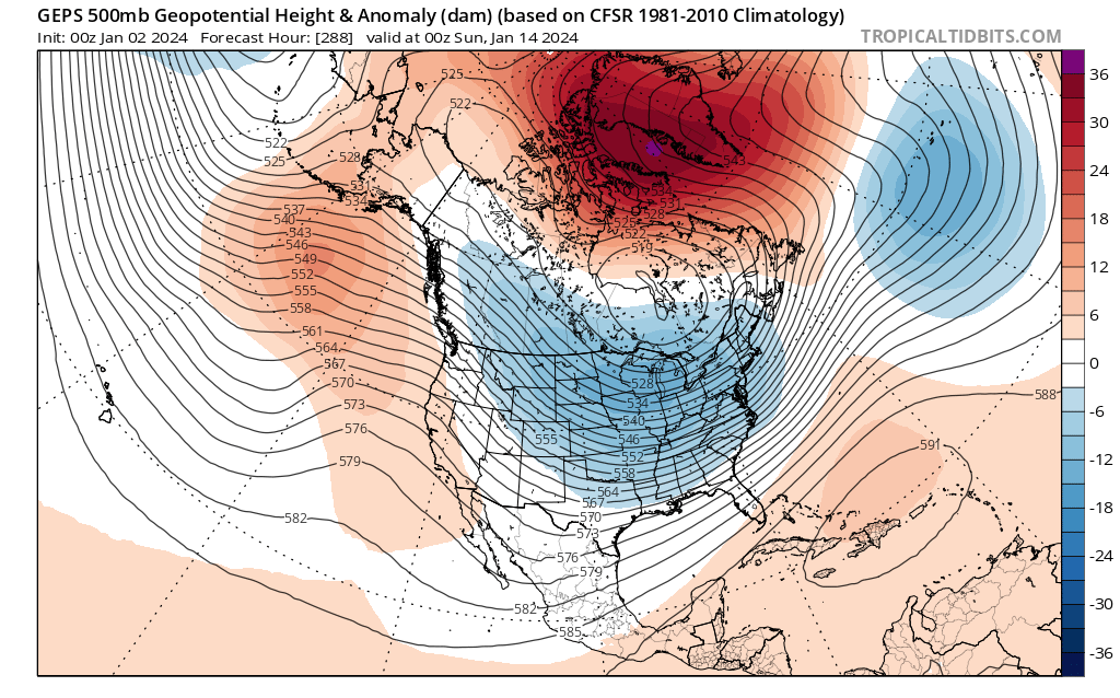
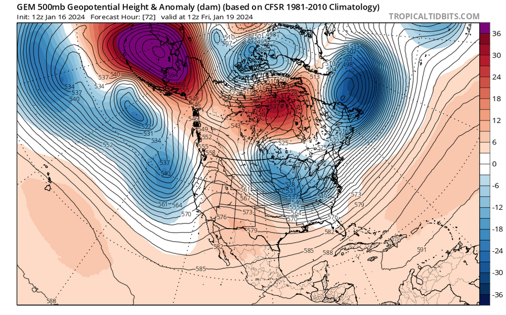
6Z GFS actually trended toward the Euro for the MLK weekend storm (I guess it's running more into Tuesday now but that's how I keep identifying it). The weekend after remains perhaps more intriguing given how the players are setting up on the field. Anywhere from the 19th to 22nd, give or take. Decaying -NAO block and a TPV traversal into the 50/50 region, ideally. The ensembles look a lot better than the operationals in this regard. The energy is there on the GFS, but it's shunted south and out to sea by the TPV strength. The Euro is more favorable, with the TPV less concentrated and more elongated, which allows for that Low to pop in the Tennessee Valley and move into the OV (not ideal but right now that's unimportant). The GFS results in a boundary to our south, while the Euro brings the boundary much closer to us. The GFS really prefers keeping that blob of cold north of Wisconsin/Michigan instead of moving it out, but the trough remains in the East and that's some real cold (too cold?). The strength of that displacement of the PV is what leads to the suppressed look. It's showing negatives for lows and single digits for highs next week. Honestly, that's colder than what we typically want to see if we want snow, but it could be overdone (GFS has a habit of that), or maybe the cold shot is transient and it regulates a bit before our next storm threat. It looks like whatever happens that weekend blows up the pattern. We might have a reshuffle for the final week of January. Some of that could be influenced by the MJO moving into the Maritime Continent, but we lose the -NAO and the -AO is weakening. The good news is the pacific looks okay for now. The longer-range stuff shows a similar look to now returning in short order, early February. Probably means we don't have to cancel winter yet. -
Pittsburgh, Pa Winter 2023-24 Thread.
jwilson replied to meatwad's topic in Upstate New York/Pennsylvania
Agree with you guys. I'm still watching the possibility for MLK weekend. All the ensembles are in agreement with a TPV lobe over on our side of the continent. It's not quite in the 50/50 region, but it should - at least - provide ample cold and reduce any mixing concerns, although there's a wide range of possibilities from suppression to Apps runner. The GEPS is a bit more elongated and stretched with the cold versus the GEFS and EPS. The only other problem is the OP GFS, among others, wanting to retrograde all that energy back west underneath the NAO block. We'd prefer it to slide east instead. In theory, if we get the timing right between waves, it could still be good for us. The GFS kind of gets there, but I question how high the ceiling might be for an event in that circumstance. The progression of the wave is too fast to be historical, but maybe something moderately sized. If you're big game hunting, you'll notice the NAO block recedes the following weekend (20th) and that TPV spills into the more ideal 50/50 region. We are timing that with a western ridge popping up in the Spokane / Boise area. Textbook KU setup on the field. We will see if that look holds going forward as the preceding waves are completed. -
Pittsburgh, Pa Winter 2023-24 Thread.
jwilson replied to meatwad's topic in Upstate New York/Pennsylvania
To add to the test of this progressive system: SREF plumes last three runs have averaged between 3.5" and 4.5" total. Even taking off the top two outliers from last run the average remains almost four inches. Be interesting to see which blend wins. SREFs are typically overdone, only four members have less than two inches, but that's an interesting discrepancy compared to the NBM. -
Pittsburgh, Pa Winter 2023-24 Thread.
jwilson replied to meatwad's topic in Upstate New York/Pennsylvania
I don't think those point-and-click forecasts are made by people plugging in data. I think it's automatic from their backend software / system. I want to test the NBM. Right now, it says 9% chance of snow exceeding 4" and 43% chance of snow exceeding 2" (this is in the city). Making a note now. -
Pittsburgh, Pa Winter 2023-24 Thread.
jwilson replied to meatwad's topic in Upstate New York/Pennsylvania
Agree on your last point, and I'd be remiss to mention that there's a chance we could be dealing with a train of cutters while the West and that nasty -PNA sorts itself out. Unfortunately, the long-range Euro looks a lot like the CMC (GGEM) in this regard, while the GFS essentially has a +PNA at that same time, which is what would help drive our MLK weekend storm. Which suite has the better grasp? Is the GFS too fast and progressive with the pattern? However, what the GFS doesn't have that the other two do is a strengthening Alaskan ridge. Get a -EPO and a -NAO formed into a massive longitudinal block and everything is forced underneath into the U.S. THAT would be an interesting development. I really think in the next 45 days or so there will be at least one significant KU somewhere. Whether we feel those same effects is the pertinent local question. -
Pittsburgh, Pa Winter 2023-24 Thread.
jwilson replied to meatwad's topic in Upstate New York/Pennsylvania
I just ran through the 12Z run, and I think the first period to watch for something is next weekend. Caveat emptor: we've seen the danger with long-range solutions. If you're still depressed by long-range tracking then look away now and don't come back until next Friday. The Canadian has a beautiful look with a 50/50 held in by the growing eastward -NAO block. The shortwave is rolling through Tennessee. The evolution shows suppression, which is possible, but that sort of detail at this range is largely ignored. For now we're just looking to get the players on the field. The only problem is it's sort of on its own at that particular timeframe. The GFS has something a little later with a ridiculous spike in the western ridge. The GFS holds the energy back which corresponds with its deep central trough paired with the aforementioned ridge. The Canadian is dropping a massive -PNA at this same time, so they are basically opposites in the west, but the GFS potential would be even greater. It runs the low right up the Appalachians after deepening in the Gulf. It also shows a TPV lobe splitting and settling in to the north of us. The GFS also shows that beautiful triumvirate of High pressures, a Banana high +1. The question would be which of these elements wins out: the -NAO, the Southeast Ridge, or the TPV lobe? That SER actually helps to push the storm further inland, which might be better for us in Pittsburgh and worse for the coastal areas, but it could also be too much of a good thing. Then there's the blocking which modeled too strong or too weak can alter the formula. The other danger here is this is the first operational run to show a solution like this, so it could easily disappear at 18Z, thus taking the time to analyze it pointless. HOWEVER, the look from the GFS is mostly supported by all the Ensembles (GEPS, GEFS, and the EPS). They all show these players in position (West ridge, central trough, SER, transitioning TPV). They aren't exact mirrors but close enough at 200+ hours to consider the OP isn't totally off on its own. BUT, once again - I mainly wanted to point to the potential of the MLK weekend. Maybe we come up empty. Right now it looks as if we could have a better front-end position for something (unlike this weekend). Hopefully those looks don't evaporate now because, dammit, I tried!
-
Pittsburgh, Pa Winter 2023-24 Thread.
jwilson replied to meatwad's topic in Upstate New York/Pennsylvania
This is the problem with modeling in a fast flow. The models waffle all over the place constantly, and there's all these discrete pieces of energy, they can't decide what's going to win. It might become a nowcast event, but I still think the long range holds promise. That big -NAO block hasn't gone away, and the longer range shows a relaxation of sorts for the -PNA. Maybe it just comes down to timing something right or watching for that block to relax. There's real potential, which is more than I can say for the last couple years. -
Pittsburgh, Pa Winter 2023-24 Thread.
jwilson replied to meatwad's topic in Upstate New York/Pennsylvania
For whatever reason, I don't know the answer, those Miller A tracks are seemingly less frequent now. I would assume Miller As are more common in Nino winters because of the stronger forcing from the STJ while Ninas are more northern stream dominant, and we've had a long-term Nina-esque background state that could be a limiting factor. The last really big storm traces back to the Super Nino season in January 2016. Sadly, Pittsburgh metro was largely fringed during that storm, but I know Morgantown got about two feet. Almost all of the storms in recent history have been true Miller Bs or some kind of hybrid that combines an inland primary phasing with an emerging gulf low. Yeah and that's what I'm seeing with the old primary in the models. They want to key on a single low - the gulf / coastal one - and phase out the other. The energy in the CONUS is scattered all over the place. Compare this weekend's look with essentially four distinct pieces of energy to next week's single bowling ball over Texas. The Canadian looks better because it's a deeper system on the Coast with a bit more energy consolidated. The Euro is between the two. Then there's the NAM which I'm pretty sure is some type of error. Haha, well I wouldn't necessarily go that far, but it's certainly no guarantee we get a hit. The GEFS at range is now showing a full-latitude ridge combining the -NAO and a southeast ridge (Phase 4 of the MJO). That's a very warm look for the entire East (January thaw?). This is paired, naturally, with a -PNA trough that dumps real cold into the West. Eventually, that cold would have to filter east, and it's the character of that evolution that would matter. Does a TPV lobe split and elongate under the -NAO block? That would be good for us. If it just cycles around out west or the -NAO weakens and creates a transient cold shot through the region, we would need a pacific pattern change to ever get a chance or get extremely lucky on timing. That's why I mentioned when the -NAO block dissipates, you go KU hunting. Time it right and you get a TPV lobe into the 50/50 which blocks a storm downstream long enough to intensify but also doesn't suppress it into North Carolina. You also move the western trough towards the middle of the country which presents an opportunity for the various jets to interact, potentially merge, while creating ridging out West and an elongated trough axis in the East. -
Pittsburgh, Pa Winter 2023-24 Thread.
jwilson replied to meatwad's topic in Upstate New York/Pennsylvania
It seems the big problem going forward is going to be a -PNA. Now we have most of the energy being held back into the west, a pronounced trough there, and zero blocking. The 50/50 is more like 60/60. The issue with the following storm is there is no competition in the CONUS, so it sucks up all the energy, and there's no block to keep it from cutting - even if it were to weaken somewhat closer to onset. That's the storm that helps setup a -NAO for the following weekend. However, the -PNA continues and could potentially cancel out the block up north. The question going forward then is: who wins between a -PNA and -NAO? Recent history suggests the pacific wins, but that's TBD. We also see, in this example, that a true Miller A will only work for the Pittsburgh area when it has time to really deepen and strengthen before approaching the coast. It has to start bombing out in the Gulf. Without the inland primary like in a Miller B, a progressive flow shunts all the snow south and east. Miller Bs present their own problems, of course, like mixing and dry slots, but without that initial primary coming across, you risk getting nothing but high clouds. -
Pittsburgh, Pa Winter 2023-24 Thread.
jwilson replied to meatwad's topic in Upstate New York/Pennsylvania
Next I wanted to look at the charts. Let's start with the 0Z from earlier. Here we can see the primary differences. Notice the flatter flow to the north of our system which acts as a quasi-block. It both prevents the storm from gaining too much latitude and slows it down a little bit. The combination results in a stronger shortwave. You also have that piece of energy along the west coast digging a bit deeper which opens the entire CONUS-wide trough. This is harder to picture at the surface, but here we see the flatter flow once again and how that energy up north was elongated and less phased. The flow is mirrored on the H500 above. The energy in the central U.S. is also less concentrated, at least partially because of the west and east coast systems separately. But then we get into the 12Z models. Here we see that west coast energy is a little less pronounced, and instead the energy over Texas is digging dramatically southward. This creates a more zonal look to the flow out ahead of it. It's less into a trough on the east coast and more straight-line. We also see heights rising up north, mostly because that energy that was spread out or elongated before is now more concentrated to the East. Here we can see that northern piece a bit better. Notice again that at 0Z it was flat and stretched. Now it's a consolidated blob pushed slightly to the East. This is helping to pump those heights out ahead of the east coast shortwave, which both pulls it a little north and also opens the flow out ahead so it can escape more freely. Instead of our storm getting trapped underneath, it is now free to slide off the coast and rotate north around the rest of the waves. These are the key pieces of energy to watch going forward. We don't have a true block so it could really go either way. But if that energy up north phases too soon, we get conditions that allow our storm to progress along the boundary instead of getting dug in. The energy behind it also isn't helping, though these pieces are all acting in concert. We might still get a nice 3-6" event, but the ceiling is much lower than if we had more optimal interactions. -
Pittsburgh, Pa Winter 2023-24 Thread.
jwilson replied to meatwad's topic in Upstate New York/Pennsylvania
Same NBM, and considering the blend, the average snow across all models is 5" (must be skewed upward by a few big hits).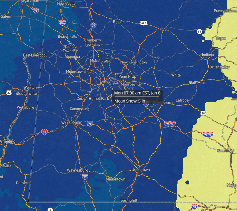
-
Pittsburgh, Pa Winter 2023-24 Thread.
jwilson replied to meatwad's topic in Upstate New York/Pennsylvania
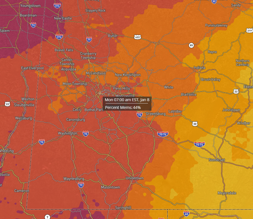
Here's the 13Z NBM (National Blend of Models). I set the threshold at 4", so right now this predicts our odds of >4" at 44%.
-
Pittsburgh, Pa Winter 2023-24 Thread.
jwilson replied to meatwad's topic in Upstate New York/Pennsylvania
Bear with me, all. I'm going to make a few posts here. Haven't done this in a while so I'd like to get those snow juices flowing again. Yep. We notice a sort of "see saw" action with the energy over Oklahoma / Texas. As it digs southward, it pumps the flow ahead of it and bumps our shortwave northward. The other problem, which I'll illustrate below, is the open confluence to the north. The 12Z Euro shows this almost zonal look to the flow, but it's north enough we get better snow than at 6Z. -
Pittsburgh, Pa Winter 2023-24 Thread.
jwilson replied to meatwad's topic in Upstate New York/Pennsylvania
Since I'm here, I'm watching the 12Z GFS roll out. Looks pretty similar to 6Z thus far. Primary is pushing into southern West Virginia which is starting to get a little close for the mix concerns. The timing of this transfer is relevant. One of the big differences between the 12Z and previous runs is the energy in the Central US is digging further south and we're getting more northern stream interaction (CMC and GFS). This is a fast-moving system so we won't have time to set up for something really big, but the dynamics will determine how potent a bomb we get for 8-12 hours. It's good they are both there, because the 6Z Euro trended away from this sort of environmental interaction. Question is whether Euro follows. -
Pittsburgh, Pa Winter 2023-24 Thread.
jwilson replied to meatwad's topic in Upstate New York/Pennsylvania
To be honest, I almost want to look beyond this event and notice both the Euro and GFS setting up a rather significant -NAO block the following weekend. The ensembles and operationals all have it. Traditionally, when you would weaken a block of this magnitude is when you hunt for the KU, but it's presence looks likely to deliver us the first chance of real cold this winter. Anything that happens underneath is worth watching. It's been a while since we've had this setup.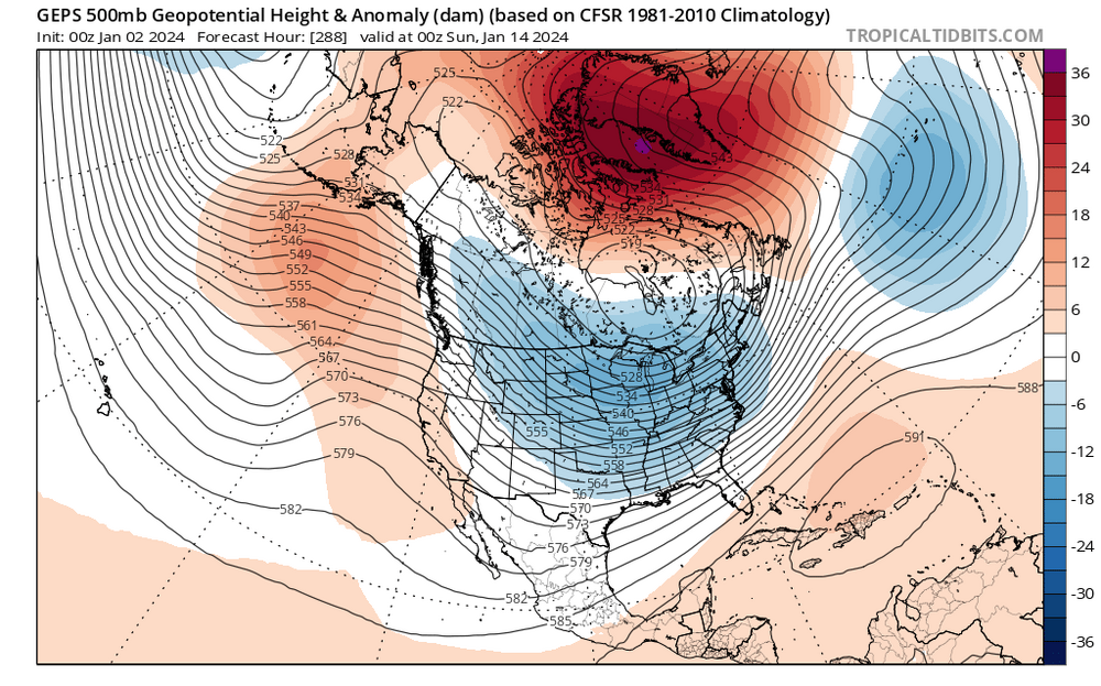
-
Pittsburgh, Pa Winter 2023-24 Thread.
jwilson replied to meatwad's topic in Upstate New York/Pennsylvania
Half of the 30 GEFS members show a 6"+ storm for Pittsburgh metro or are very close to it. Perhaps 10 certain and then a few that are inexact given the resolution. That's not quite what I'd consider "honking," but it's still quite good at this range. A handful more show a fringe event (borderline minor to moderate or a fringe special). Five show what's basically a non-event.