

jwilson
-
Posts
1,234 -
Joined
-
Last visited
Content Type
Profiles
Blogs
Forums
American Weather
Media Demo
Store
Gallery
Everything posted by jwilson
-
I'd say put all of PA under one subforum, but I realize the climates are diverse and it certainly isn't a perfect fit. We all have our "IMBY" preferences and microclimates. Central PA and Western PA only have one thread each and for some reason are lumped in with Upstate New York. That part doesn't make a ton of sense, either. Would Upstate NY (which I assume includes Western NY) fit in better with the NYC forum, making separate NY and PA regions? NJ can remain split - north going to NY and south going to PA. DE could perhaps also split - north into PA and south into Mid-Atlantic. As someone that has lived in three of the four corners of PA, I can attest there are considerable differences. Nonetheless, since all the regions are small on their own, maybe it would be worth it to combine them all into one moderately sized discussion pool? I like following what is happening all over PA and having to jump between forums is somewhat an inconvenience, albeit a very minor one.
-
Seems like one of those where the typical north trend won't happen because it would actually benefit us. If it doesn't work out, after some more 50 degree rain on Saturday, the system next Monday could lend itself to a quick thump. Everything in this current pattern is fast moving. Doesn't allow for much major snow but we could score a respectable thump at some point. It certainly doesn't seem like a shut-out pattern (at least not for everyone, never can be too sure).
-
It is still early - too early, really - to talk about a potential storm next weekend, but my initial concern would be too westward of a track, leading to warm tongue concerns. A strong CAD signature isn't relevant west of the mountains. If it was the height of winter with deep cold maybe I'd feel otherwise. December is a bit more marginal.
-
Most of the forecasts I've seen are calling for snow in the middle and peak of winter, but the book-ends may be mild and undesirable for snow lovers. If January comes and goes and we're still below average, only then will I get uncomfortable. For now the lack of snow is merely mild disappointment.
-
Just what we want and expect to see on December 1st. Severe thunderstorms. Oh, we're not in the southern hemisphere?
-
I'd be happy with an inch, but it looks to dry out as the last one did. I'll expect nothing. Last 30 years in November: 13.9" most (1995-96) Trace least (9 different years) 2.3" average In addition to those nine "trace" years, we can add four more years of less than an inch received. To me that is more or less equivalent to nothing. 13/30 or 43% of the time. Those aren't great odds of getting relevant accumulating snow in November. Add in four more years with between 1" and 2" and that's over 50% of the time we can't even muster 2" in November, total. Take out those two unusual high-end amounts ('95 and '13) and the average drops to 1.6" instead.
-
High-res NAM goes to all snow at 3 PM tomorrow in these parts. GFS is a bit slower and keeps the precip around for longer, through 8 PM or so. Neither gives us much at all and leaves a nice little hole over Pittsburgh. Maybe we can grab a sloppy inch for a taste. As usual the ridges and lake counties do better and might get a couple.
-
FIrst measurable snowfall last year was November 15/16. I think it is possible we can beat that date this year. Bigger question may be whether we can sustain a favorable pattern this winter as compared to last.
-
Pittsburgh PA Area Spring and Summer 2019
jwilson replied to CranberryWX's topic in Upstate New York/Pennsylvania
Well, at this time of year, probably not much (super low ratios). 5-10" maybe? If we can get this into some cold in January, perhaps a nice foot or two. -
Pittsburgh PA Area Spring and Summer 2019
jwilson replied to CranberryWX's topic in Upstate New York/Pennsylvania
THE WARM TONGUE DOES NOT ABATE! Seriously though, we had a fairly prolonged period of -NAO through this year (spring/summer). Hopefully that holds into the winter. Seems like it has been a while since we've seen the same during the cold seasons. It would really help our chances. -
Pittsburgh PA Area Spring and Summer 2019
jwilson replied to CranberryWX's topic in Upstate New York/Pennsylvania
I was still living in Philly at the time, so not sure if that's the information you're after, but we managed a little over 12" (most all of it was on the 6th, but a little fell before midnight). Our bigger storm was a few days later on the 9th and 10th. There we pulled >23" and some of the heaviest snow I've ever seen in person, with visibility down to about 200 feet. -
Pittsburgh PA Area Spring and Summer 2019
jwilson replied to CranberryWX's topic in Upstate New York/Pennsylvania
Remember when September used to be a cool month? I don't know if data confirms this, but it seems like we're losing four seasons and basically contracting down to two (6 months of summer and 6 months of winter). Looks like the heat will continue into October again. -
Pittsburgh PA Area Spring and Summer 2019
jwilson replied to CranberryWX's topic in Upstate New York/Pennsylvania
I was planning on hitting the links Friday or Saturday.. maybe not such a good idea now? I have played in the heat before, it's just miserable. And no alcohol, of course. -
Pittsburgh PA Area Spring and Summer 2019
jwilson replied to CranberryWX's topic in Upstate New York/Pennsylvania
Here's a couple images from last night that I captured on that final severe storm of the evening. This was on the very southern edge of the cell. First is the possible wall cloud. This isn't the best it looked, but it's the only real view on tape I managed to grab of it (this is actually a still from a video). It looked a bit more defined as it approached. There was a clear inflow band, as well (extending off to the right of this image). Unfortunately, I didn't end up attempting to get any more pictures or videos of it for some dumb reason. Here is a quick GIF of some lightning I captured. It got pretty intense. Evidently there was hail with this storm further to the north, but the core of the storm missed me. (If image isn't working, click here.)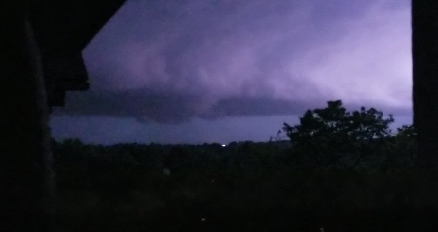
-
Pittsburgh PA Area Spring and Summer 2019
jwilson replied to CranberryWX's topic in Upstate New York/Pennsylvania
Just caught the southern tip of that severe storm. No hail, impressive light show, looked like a wall cloud as it moved in (hard to make out at night for certain but thanks light pollution). Some nice video, as well, but my phone is almost dead so I'll see what's worth revisiting tomorrow. -
Pittsburgh PA Area Spring and Summer 2019
jwilson replied to CranberryWX's topic in Upstate New York/Pennsylvania
If today busts for the southern regions, the enhanced risk area shifts south for tomorrow, but it might end up putting the city locales on the northern fringe instead of the southern. Could still be a miss. There will be a final chance region-wide on Thursday. The probabilities look lower in severe terms, however, at least for now. -
Pittsburgh PA Area Spring and Summer 2019
jwilson replied to CranberryWX's topic in Upstate New York/Pennsylvania
Couple more chances for severe upcoming, but thus far this year there hasn't been much locally. I think June is our peak season, though. -
Pittsburgh/Western PA Banter & Complaint Thread
jwilson replied to blackngoldrules's topic in Upstate New York/Pennsylvania
Yeah, I get why they were complaining (I think they were at historic levels of futility for snow), but everyone knew they'd play catch-up before long. Some people just need perspective, really. There's quite a few in the MA forum especially that would go insane living here. I can't imagine some of those guys making it 10 years without a double-digit event. -
Pittsburgh/Western PA Banter & Complaint Thread
jwilson replied to blackngoldrules's topic in Upstate New York/Pennsylvania
This just about sums it up for us. Welcome to the Screw Zone™ for all time. -
Pittsburgh/Western PA Banter & Complaint Thread
jwilson replied to blackngoldrules's topic in Upstate New York/Pennsylvania
The more these rain storms occur, the more I think this just isn't our winter. It was 0F last night and is close to 50F today. The atmosphere wants to rain here and that's it, as evidenced by our wettest year on record. This is a harsh pattern we've been set in since mid-2018 probably. If we're lucky, we'll dry out just in time for next winter. -
Pittsburgh/Western PA Banter & Complaint Thread
jwilson replied to blackngoldrules's topic in Upstate New York/Pennsylvania
We're well below normal so far (if we finish that way, it would make 3 of the last 4 winters). I agree that expectations for this winter were high. Things looked to align, but at this point, we're going to need a backloaded winter. The blocking that I think we require continues to be two weeks away in the long-term. Maybe by February it will actually coalesce. I'm hoping we don't revert to a bad pacific pattern or lose our moisture conveyor if the blocking comes together, but that's always possible. -
Pittsburgh/Western PA Banter & Complaint Thread
jwilson replied to blackngoldrules's topic in Upstate New York/Pennsylvania
Always a bridesmaid ... -
Snow and more
-
-
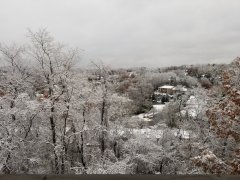
From the album: Winter
-
Pittsburgh/Western PA Banter & Complaint Thread
jwilson replied to blackngoldrules's topic in Upstate New York/Pennsylvania
I don't mind transient warmth in winter so much, say a day or two in between pattern flexes. I'm not a huge fan, however, of two to three weeks of the doldrums. Maybe we have once chance as the "new" pattern shuffles, but it doesn't look all that promising right now.

