OKwx_2001
-
Posts
69 -
Joined
-
Last visited
Content Type
Profiles
Blogs
Forums
American Weather
Media Demo
Store
Gallery
Everything posted by OKwx_2001
-

2021 Atlantic Hurricane season
OKwx_2001 replied to StormchaserChuck!'s topic in Tropical Headquarters
It's not even peak season yet. It's not like August first hits and then it's a cane fest. There's a reason why many consider 8/20 to be the start of peak season. In the last decade there have only been 3 storms before 8/20 to get stronger than Cat 1, and none of those were majors. I've got a feeling a lot of your posts on here claiming this season is going to be inactive are going to age very very poorly... -
2021 Atlantic Hurricane season
OKwx_2001 replied to StormchaserChuck!'s topic in Tropical Headquarters
HMON shows 95L hitting PR as a near major Meanwhile the HWRF shows an open wave Gotta love the hurricane models -
There's definitely quite a bit of possibilities. I think we'll be looking at a remnant low trying to get going in the gulf. That being said, if it can get to the gulf without much interaction with Cuba, I think it may be able to make a run for strong TS maybe even a Cat 1 hurricane. But if it gets tangled up with Cuba then there might not be anything left of it
-
I highly doubt that. We'll have to see if it survives the islands first. Not to mention a major hurricane in the first half of August is very rare. There hasn't been one since Dean in 2007. Conditions may be favorable, but I don't think it's going to be a major. Still needs to be watched though.
-
2021 Atlantic Hurricane season
OKwx_2001 replied to StormchaserChuck!'s topic in Tropical Headquarters
I know the focus is on PTC6 (and rightfully so) but the wave in the eastern Atlantic looks like it might be trouble down the road. It's a long ways out but it may have a chance to get pretty strong if it avoids land. It's just been tagged as Invest 95L -
2021 Atlantic Hurricane season
OKwx_2001 replied to StormchaserChuck!'s topic in Tropical Headquarters
Well I came here for a discussion and that's tough when I see you posting nonsense like every 30 seconds -
2021 Atlantic Hurricane season
OKwx_2001 replied to StormchaserChuck!'s topic in Tropical Headquarters
What is this post? I have no idea what I just read lol -
2021 Atlantic Hurricane season
OKwx_2001 replied to StormchaserChuck!'s topic in Tropical Headquarters
Come on now just because one model shows an active EPAC and one guy lowers his numbers a bit does not mean the season is cancelled. Early August isn't usually very active in the Atlantic anyway. Later in the month things start to pick up. Not to mention the GFS showed major after major in the EPAC last year and that didn't happen and so far it's not happening this year either, although the system behind TD11-E might have a better chance to get strong. And this isn't even an El Niño season lol -
They do that all the time. They come up with their own intensity estimates that many times have zero data to support it. I don't pay any attention to them.
-
This looks like at least a TD to me, even though the center is exposed. Up to 70/70 odds of development on the latest TWO.
-
Severe Weather May 26th- 28th 2021
OKwx_2001 replied to weatherextreme's topic in Central/Western States
Huge severe warning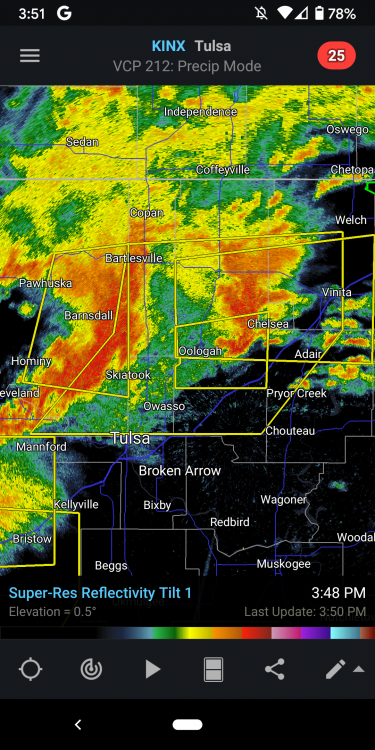
-
Severe Weather May 26th- 28th 2021
OKwx_2001 replied to weatherextreme's topic in Central/Western States
Yeet
-
Severe Weather May 26th- 28th 2021
OKwx_2001 replied to weatherextreme's topic in Central/Western States
Looks really sloppy for tornado potential but that was never the main threat. Hail and wind potential is definitely there -
Severe Weather May 26th- 28th 2021
OKwx_2001 replied to weatherextreme's topic in Central/Western States
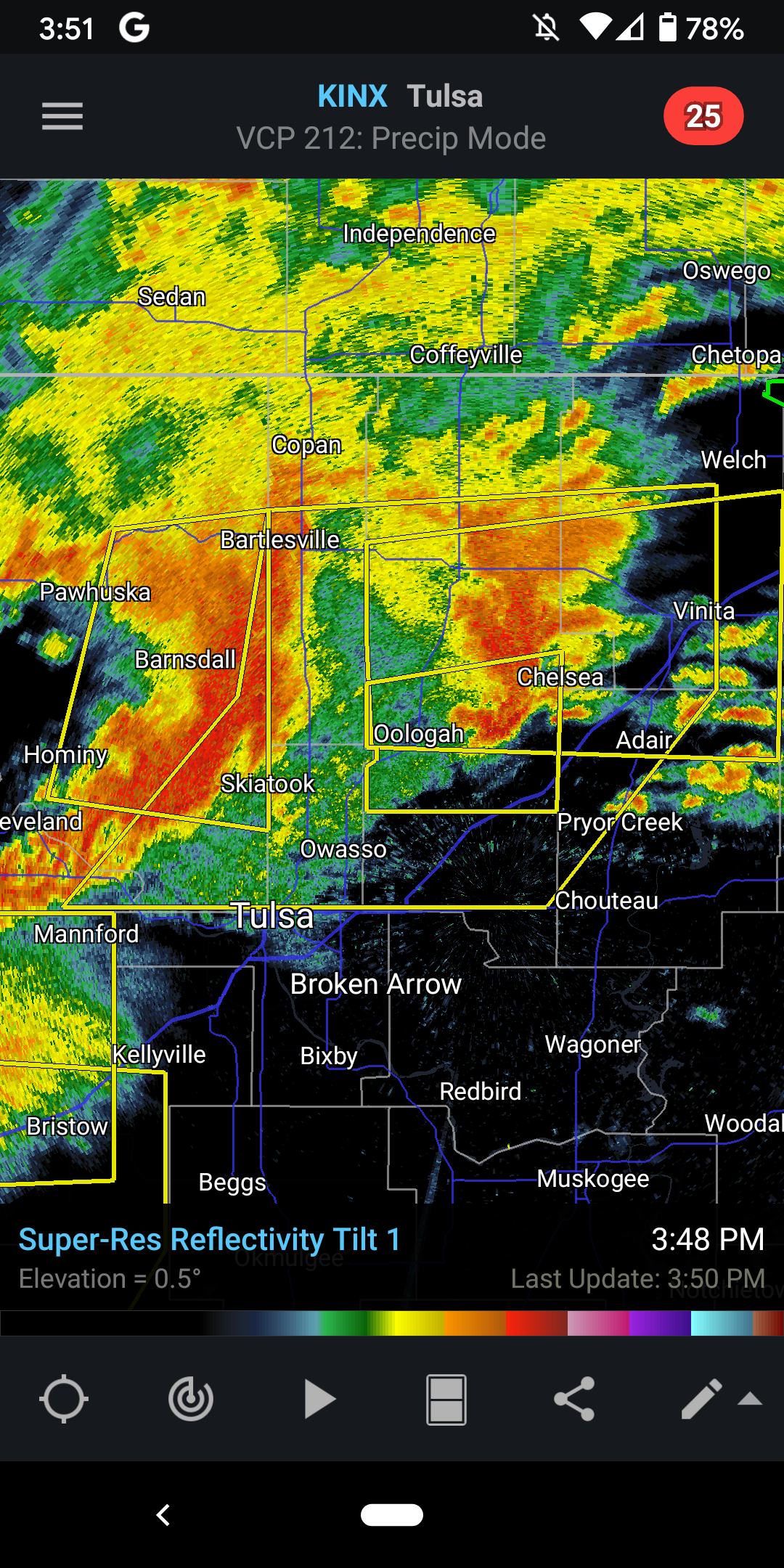
Looks like an OFB about to enter Tulsa county from the north -
Severe Weather May 26th- 28th 2021
OKwx_2001 replied to weatherextreme's topic in Central/Western States
Yep it's been a warm one for sure... The potential is there -
Severe Weather May 26th- 28th 2021
OKwx_2001 replied to weatherextreme's topic in Central/Western States
Starting to get some clearing here in Tulsa so that will be concerning if it continues. Currently at my outdoor job so I hope the big stuff holds off until I get home (I'm off at 2). I would much rather track it at home than drive in it. -
Severe Weather May 26th- 28th 2021
OKwx_2001 replied to weatherextreme's topic in Central/Western States
10z HRRR has the storms developing much earlier than previous runs. As early as late morning. I feel like that's too early for tornado potential but it will be interesting if those storm end up materializing or they even remain on later runs -
Severe Weather May 26th- 28th 2021
OKwx_2001 replied to weatherextreme's topic in Central/Western States
Tomorrow still looks like a big severe weather day but not as big as it did earlier. Might see a wind-driven moderate somewhere but I think they'll hold off until the 13z or 1630z outlook for that, if even at all. I think morning convection could be a big issue but then again it's late May so who knows. We'll have to see if we get any clearing later in the day. -
Severe Weather May 26th- 28th 2021
OKwx_2001 replied to weatherextreme's topic in Central/Western States
I'm in the southern part of the 10% tor risk for tomorrow. We'll see what happens. I've only had 1 severe thunderstorm warning this year so this should break the inactive streak. As long as the tors stay away from my house... And anyone else's -
Severe Weather May 26th- 28th 2021
OKwx_2001 replied to weatherextreme's topic in Central/Western States
Wow that's one of the more bullish ones I've seen from them at this range. Usually they are a bit more on the conservative side. Definitely concerning and I think we'll see a wind-driven moderate risk (tornado risk might be lower but still significant) by Day 1. -
It's shots like these that make me want to start chasing https://mobile.twitter.com/matternst34/status/1394091020556673028
-
It may have some severe potential but likely not much
-
Looks like a weakening closed low will be moving into the plains early next week which shouldn't bring much of a severe threat I would think, at least for the first part of the week. Could bring quite a bit of rain though. SPC hinting at a possible severe threat after that though.
-
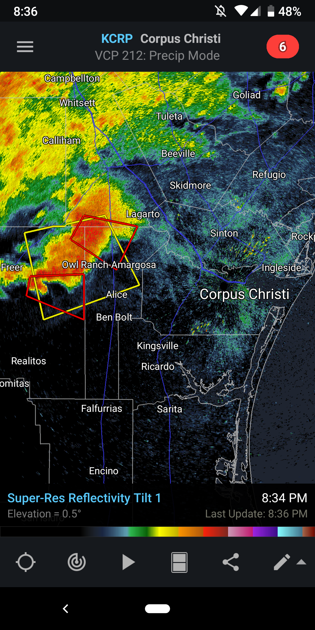
A couple of tor warned cells heading towards Corpus Christi

-
I think it'll get more active but it'll likely change between now and then. A little over a week or so ago, it looked like this week could have been active but here we with nothing but cold in most of the Plains... Meanwhile, could be some massive hail in S TX today