Sweetpea Farms
-
Posts
60 -
Joined
-
Last visited
Content Type
Profiles
Blogs
Forums
American Weather
Media Demo
Store
Gallery
Everything posted by Sweetpea Farms
-

2/14- 2/16 Winter Storm and Arctic Cold
Sweetpea Farms replied to WestTennWX's topic in Tennessee Valley
Light icing with drizzle to light rain in southern Lincoln County now, 7 miles above the AL line. Temp 30.Winds ENE at 7. Barometer 29.79 falling.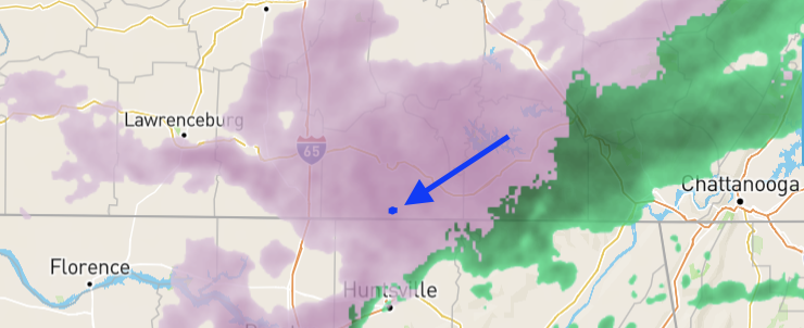
-
Pics/Videos/Stories from past weather systems in the region
Sweetpea Farms replied to Shocker0's topic in Tennessee Valley
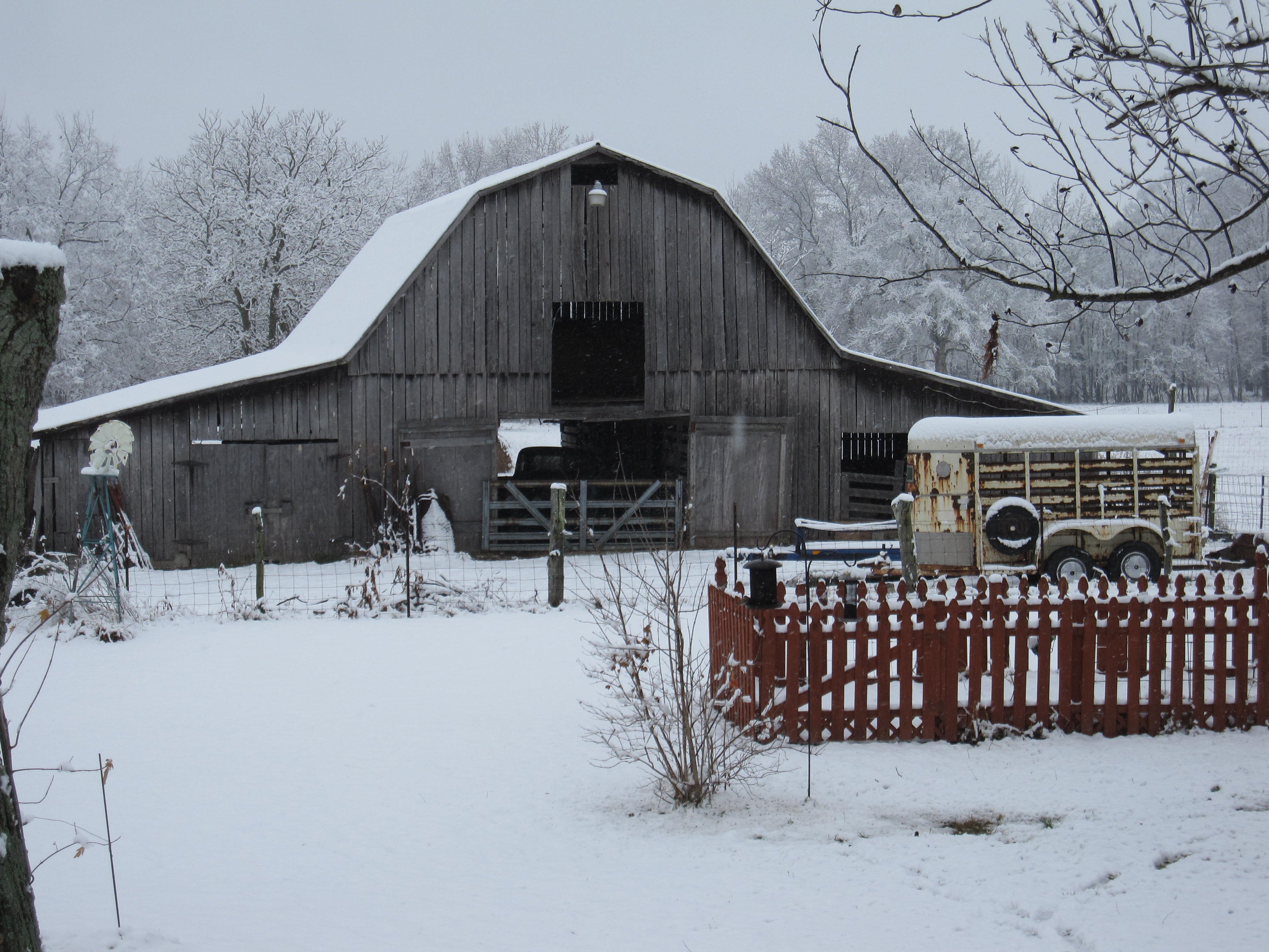
Christmas 2010, southern Lincoln County , TN.
-
All we have to do is get past Thursday and Friday here in southern Lincoln County and we are on our way to a springtime trend. 2/19 has been the inflection point since the beginning of the month and it seems to be working out. So looking forward to it. Temps here Tuesday, 2/23 should reach 60 and be in the high 50s the rest of that week. Those are right at average temps.
-
2/14- 2/16 Winter Storm and Arctic Cold
Sweetpea Farms replied to WestTennWX's topic in Tennessee Valley
LOL! Forecast now up to 5-8 inches again!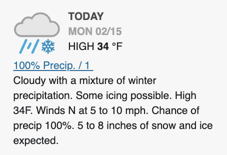
-
2/14- 2/16 Winter Storm and Arctic Cold
Sweetpea Farms replied to WestTennWX's topic in Tennessee Valley
Now raining as the lead ice edge moves over us. Temp 28.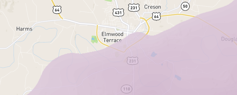
-
2/14- 2/16 Winter Storm and Arctic Cold
Sweetpea Farms replied to WestTennWX's topic in Tennessee Valley
NNE here is a good thing. It is the SW wind that carries our big storms. NNE wind pushes against them and moves them away. Been on this spot observing weather for 31 years now, that's how she rolls here. -
2/14- 2/16 Winter Storm and Arctic Cold
Sweetpea Farms replied to WestTennWX's topic in Tennessee Valley
Coming up from the south. It's just not quite here yet. Come on, 34 degrees!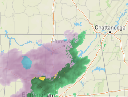
-
2/14- 2/16 Winter Storm and Arctic Cold
Sweetpea Farms replied to WestTennWX's topic in Tennessee Valley
It just dropped to 3-5 inches. I am saying 1 inch.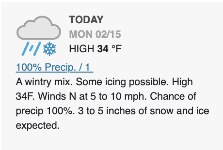
-
2/14- 2/16 Winter Storm and Arctic Cold
Sweetpea Farms replied to WestTennWX's topic in Tennessee Valley
I dunno, this shows us in Lincoln County with about an inch or so of snow coming and that was my thinking.
-
2/14- 2/16 Winter Storm and Arctic Cold
Sweetpea Farms replied to WestTennWX's topic in Tennessee Valley
My gosh, you are just 140 miles or so north of me (if we count north only and not the west part), and you are at EIGHT? Hoo boy, glad I sat this one out! -
2/14- 2/16 Winter Storm and Arctic Cold
Sweetpea Farms replied to WestTennWX's topic in Tennessee Valley
Sorry, I was watching TV when you posted! I'm with you! It can snow all it wants, but ice is bad. We dodged a bullet. I went through a couple ice storms here - worst I think was 1994, we were out of power for 7 days. I've just got my first cup of coffee, but I'm due to dive into the models to see why the heck they predict 5-8 inches of snow here when winds are NN EAST! That sounds ludicrous. But we'll see. -
2/14- 2/16 Winter Storm and Arctic Cold
Sweetpea Farms replied to WestTennWX's topic in Tennessee Valley
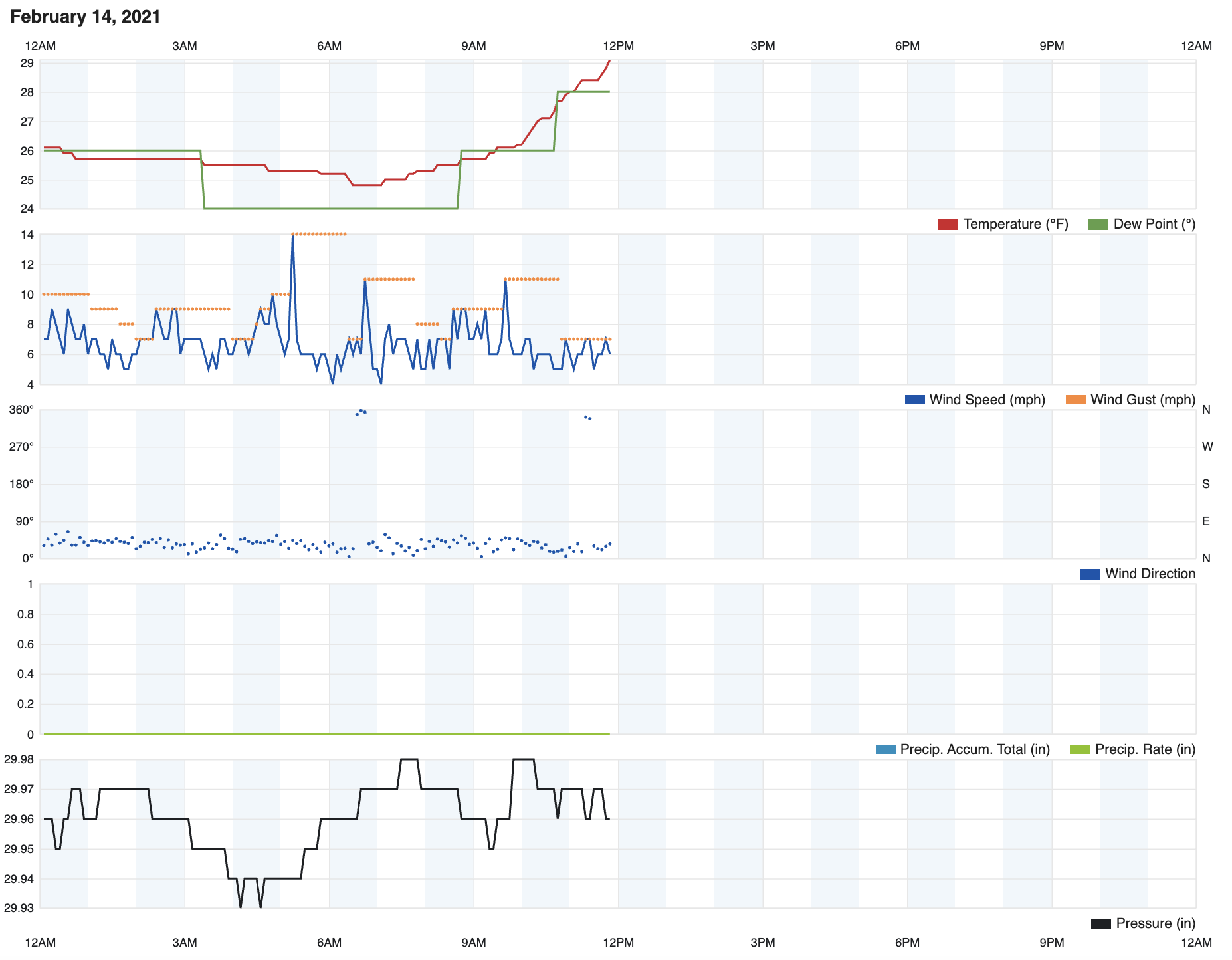
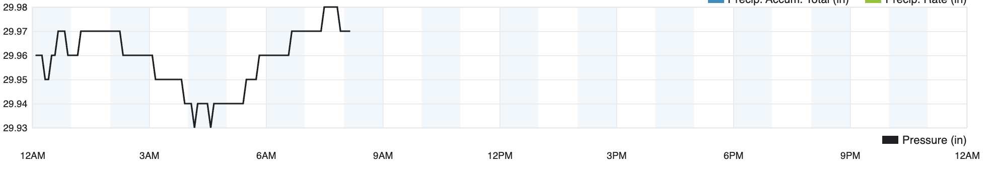
COOL – WE HAVE POWER! Last night worked out pretty much as I had expected for us in southern Lincoln County. My skepticism was accurate. That warmth to our south pushed it around us just enough. We dodged it. Overnight, we had a 78% precip probability but got 0.00". This morning at 7:30, light icing on windshields (I've seen thicker frosts), 28 degrees, winds NE at 2 and barometer steady at 29.85 inHg. A quick peek at the forecast this morning sees us with 100% chance of snow of 5-8 inches. I have not looked at any models yet. Really hoping all the members who can't log in this morning because of power outages are coping well. -
2/14- 2/16 Winter Storm and Arctic Cold
Sweetpea Farms replied to WestTennWX's topic in Tennessee Valley
Looks to me like all but one of the models I watched and those I shared were spot-on so far. Actually less precipitation here than even the accurate models had forecast. NWS has had Lincoln County in minimal impact status for 2 days. So far, correct! -
2/14- 2/16 Winter Storm and Arctic Cold
Sweetpea Farms replied to WestTennWX's topic in Tennessee Valley
Dry in southern Lincoln County. We are pretty much gonna get passed by tonight unless there is more development that I just don't see. So far, it's what I thought. We'll see about tomorrow.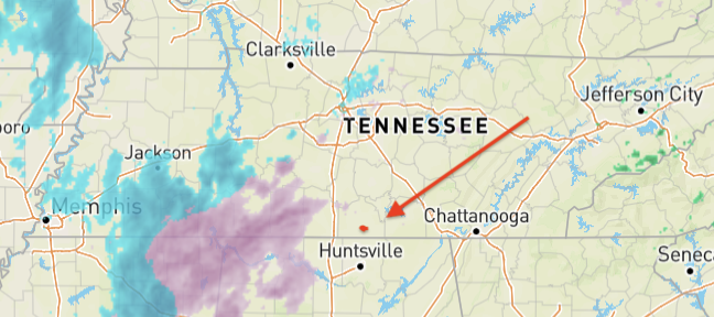
-
2/14- 2/16 Winter Storm and Arctic Cold
Sweetpea Farms replied to WestTennWX's topic in Tennessee Valley
The farm is perfectly located on top of Pea Ridge, a feature that's part of the extended Cumberland Plateau. We rarely see truly severe, destructive weather. It goes north or south. Coming from Fayetteville, you have to climb to get here. Coming from Huntsville, AL, you climb, too... it is just a lot more gradual from Huntsville. -
2/14- 2/16 Winter Storm and Arctic Cold
Sweetpea Farms replied to WestTennWX's topic in Tennessee Valley
Forecast continues to improve for Lincoln County, especially the southern half. I am 7 miles north of the AL line. Overnight, we are due periods of light rain and light freezing rain. Morning holds more freezing rain and then a switch to snow. Total precip overnight is less than originally forecast so I hope for a switch tomorrow morning quickly to snow. We might get out of this with the lights on, after all. Of course, TV is telling us the most dramatic storyline. They need to scare people into staying home. But not me! I'm hunkered down. Currently in southern Lincoln County 7 miles above Bama: 29 (high of 30); wind chill 24; winds NNE at 6; barometer 29.90 inHg. Forecast overnight low: 29. Showers commence at 8 p.m. followed by light freezing rain. Forecast high tomorrow: 32. Freezing rain to snow. Total forecast accumulation: 1 inch. That's WAY down from 5 inches this morning! BTW, has anyone forecast the coming baby boomlet in November, since this is Valentine's Day and tomorrow is an indoor, off work day for so many? I'd like to see that model!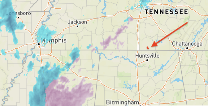
-
2/14- 2/16 Winter Storm and Arctic Cold
Sweetpea Farms replied to WestTennWX's topic in Tennessee Valley
Forecast gradually improving for Lincoln County, TN, right along the leading edge of this thing. Predicted overnight rainfall has decreased, chance of precip now 55%. Monday is the bulk of it now. Freezing rain morning and then snow afternoon is the most pessimistic outlook I have seen. Still, with overnight lows of 29 and the high tomorrow jus 31, we may end up seeing almost all of it as snow if this holds. Along the AL border like I am, I would expect my impacts to be lower than for the county as a whole. Currently in southern Lincoln County, seven miles above the AL line: 29 degrees, ground fog/mist, no freezing; winds NNE at 5, barometer steady at 29.95 inHg.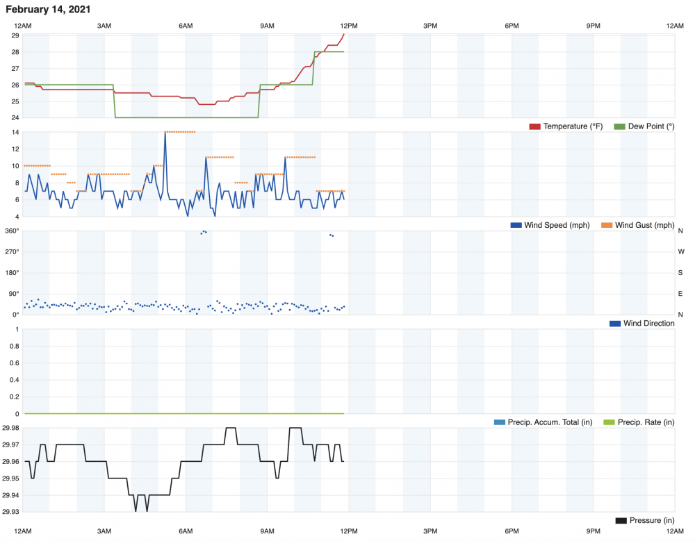
-
2/14- 2/16 Winter Storm and Arctic Cold
Sweetpea Farms replied to WestTennWX's topic in Tennessee Valley
Memphis friend reports snowfall there that started about an hour ago. -
2/14- 2/16 Winter Storm and Arctic Cold
Sweetpea Farms replied to WestTennWX's topic in Tennessee Valley
-
2/14- 2/16 Winter Storm and Arctic Cold
Sweetpea Farms replied to WestTennWX's topic in Tennessee Valley
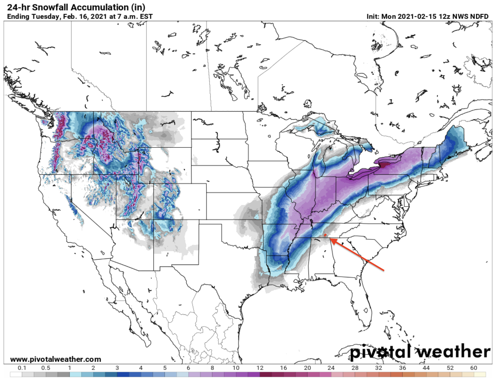
I like this one better than the last one. Shows less ice where I am in Lincoln County. I am still guessing it will be milder on the edge where I am than predicted. We'll keep power but it will be slick. I've gotta take a look at the warm side of this thing to see how much push it has. -
2/14- 2/16 Winter Storm and Arctic Cold
Sweetpea Farms replied to WestTennWX's topic in Tennessee Valley
Boy, I'd sure take an all-snow event down here for sure. -
2/14- 2/16 Winter Storm and Arctic Cold
Sweetpea Farms replied to WestTennWX's topic in Tennessee Valley
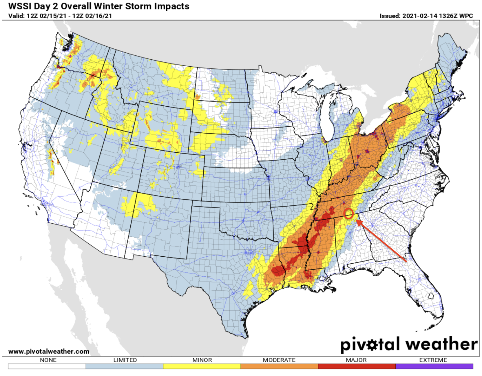
This is a good map to point how how DUMB using TV markets as dividing lines is. See the border counties in the circle on my copy? They get lumped in with Huntsville NWS and cut out of TN NWS forecasting. No way things are gonna change there right at the county lines. I have to deal with this kind of stuff all the time, living in Lincoln County.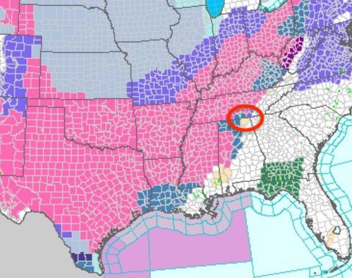
-
2/14- 2/16 Winter Storm and Arctic Cold
Sweetpea Farms replied to WestTennWX's topic in Tennessee Valley
Conditions this morning at 8:23 a.m. in southern Lincoln County, 7 miles above Bama: Light ground fog with no freezing of roads or surfaces. 26 degrees, undisturbed ground is frozen, winds ENE at 2-6 mph. Barometer 29.97 inHg and rising just a bit. My county remains right on the edge of a significant ice storm, but is barely in the minimal effects category right now. Of course, TV is going off like it is the start of WW III. The warm line for this event will be just 59 miles from me in Scottsboro, AL, (see my location on map) where only rain is forecast. What we actually get will be a matter of a few degrees temp. If its gonna dump, I'd rather have snow, please. Currently, I expect light icing here overnight to about a quarter inch maximum, then changing over to snow tomorrow morning sometime. Areas of northern Lincoln County could see 3-5 inches but where I am I expect around an inch of slick to be deposited on the ground. We'll see what this afternoon's info brings. Grabbed the neglected snow shovel off the hook in the shop this morning to put it on the porch, stacked more firewood at the door in case we lose power, brought in some cat food for the feral farm cats so we can feed them off the porch tomorrow instead of at the shop building. The cows will get an extra bale of hay this afternoon, then what else can I do but watch models and hope we get largely missed? Everybody stay safe. Tomorrow sounds like a good day to work a puzzle by the fire or something.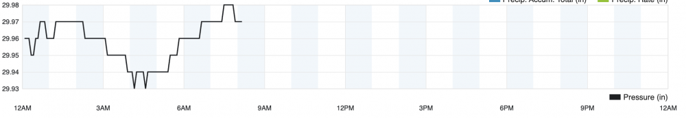

-
2/14- 2/16 Winter Storm and Arctic Cold
Sweetpea Farms replied to WestTennWX's topic in Tennessee Valley
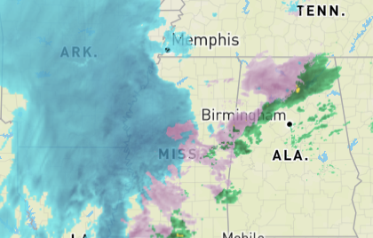
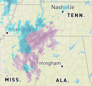
What was it, about a week ago, or 10 days or so? Forecasters then were screaming that a huge snow system would form up and barrel out of Arkansas across Tennessee. Totals in my county on the AL border were estimated as high as 5 inches. I was a skeptic then but I know that Arkansas is the source of many bad storms for Tennessee. In the end, it went north of us and only a corner of NW TN got some. This system has some of the same potential tracking characteristics, but this time the NW half of TN could be affected. This whole 15-day period has been a minefield for accurate forecasting, for sure. Waiting around on 2/19 - pivot day! -
2/14- 2/16 Winter Storm and Arctic Cold
Sweetpea Farms replied to WestTennWX's topic in Tennessee Valley
In the time it took to type the above, the Monday forecast here in Lincoln County, TN, has changed to rain to wintery mix with 1.9" accumulation.