Sweetpea Farms
-
Posts
60 -
Joined
-
Last visited
About Sweetpea Farms

-

TN valley heavy rain/flooding week of whenever
Sweetpea Farms replied to janetjanet998's topic in Tennessee Valley
Well, in southern Lincoln County we have already had 0.86 inch since the wee hours of this morning when it started. Falling at 0.04 inch per hour currently. -
TN valley heavy rain/flooding week of whenever
Sweetpea Farms replied to janetjanet998's topic in Tennessee Valley
Feeling that barometric pressure headache? Great day for it in south Lincoln County, 7 miles from Bama! My PWS...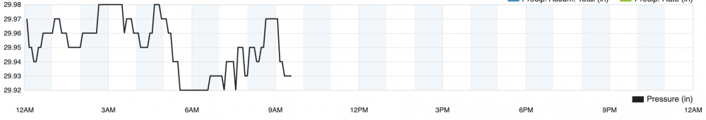
-
TN valley heavy rain/flooding week of whenever
Sweetpea Farms replied to janetjanet998's topic in Tennessee Valley
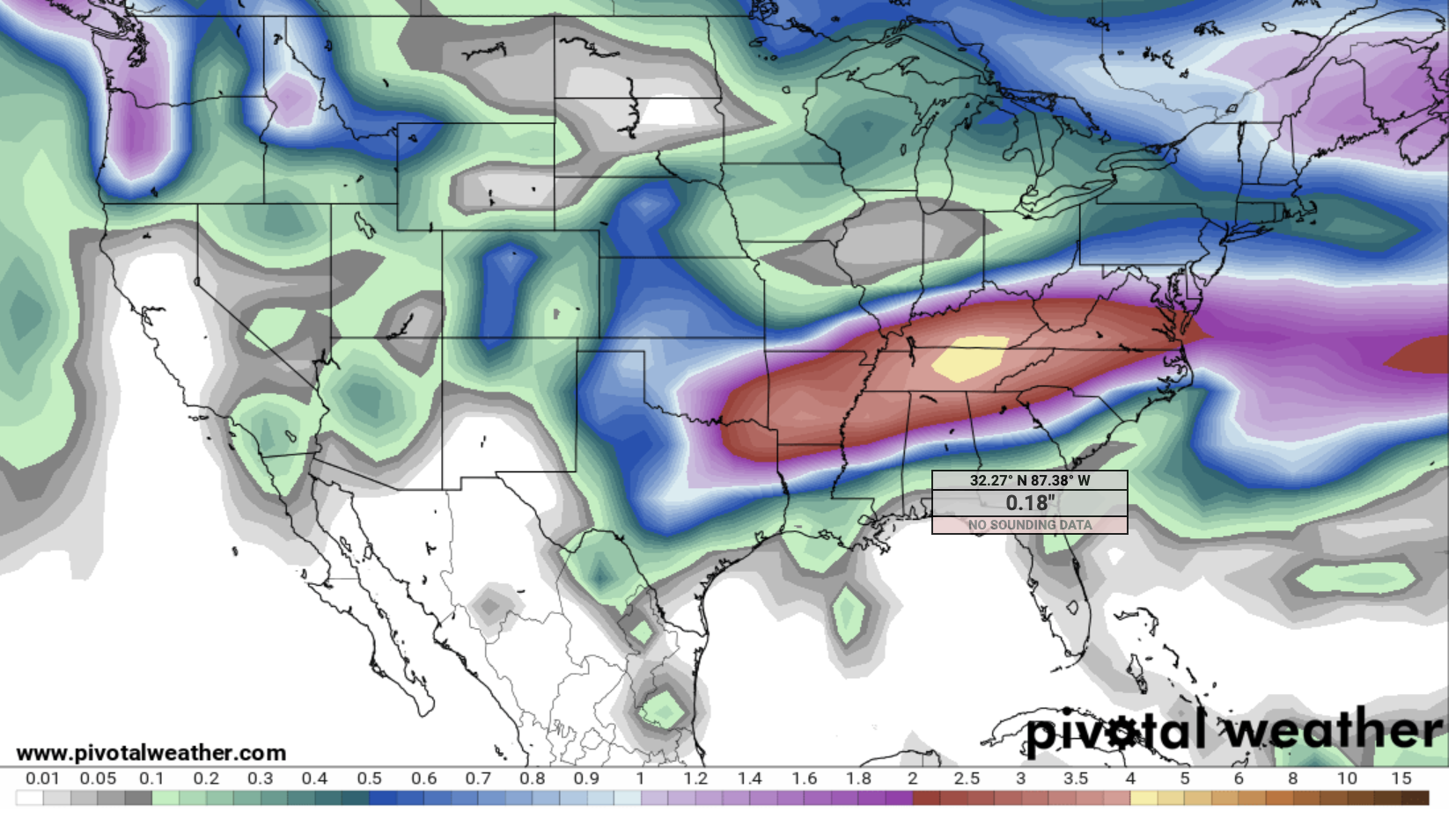
NAM shifts the heavy rain south to Mississippi and Alabama, coming right up a bit into my AL border county. Gotta go. Counting out animals in twos....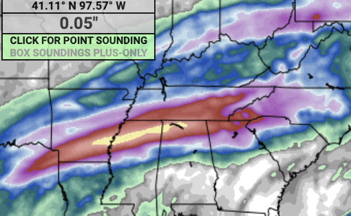
-
TN valley heavy rain/flooding week of whenever
Sweetpea Farms replied to janetjanet998's topic in Tennessee Valley
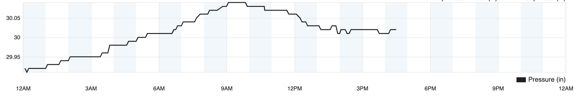
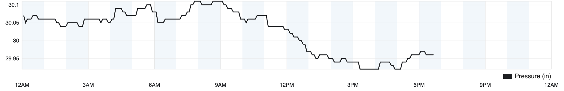
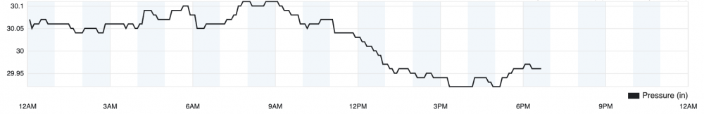
CFS cume cuts us a little slack in Lincoln County and overall, looking at 4-4 1/2" tops through Tuesday anywhere in TN, with central state the highest. Of course, it disagrees with the NAM (through Monday) about the area to be hit heaviest and extent. I dunno, I have just heard so much that has not come true regarding rains in forecasts this winter. This is like the fifth heavy rain warning for my area, and the other four petered out by quite a margin. In one, we got none! Still, I have been away from the site because I am designing my arc, just in case. How long is a cubit, again? Barometer in southern Lincoln County, 7 miles above Alabama, is a strong 30.02 inHg so far. Skies slightly overcast and 63 degrees with winds NNE at 3 mph. Rain forecast to start tonight at around 11 p.m. Looking all the way west to the West Memphis, Ark. Police Department's PWS, it is sunny there, 53, and barometer at 30.32.
-
February 17-18th Winter Storm Thread.
Sweetpea Farms replied to John1122's topic in Tennessee Valley
I've lived on the same farm 31 years, and I'll take observation of nature as a winter predictor over any other, frankly. Forecasting only goes so far, and 48 hours might be the limit of what we can accurately do now. I look at both for long-range indications but watching nature has been far more accurate about general seasonal patterns on my patch of ground. It matters a lot, too, when I am already thinking now of what I need to produce and how I need to get it done given future seasonal estimates to get my cattle through NEXT winter. Of course, most people have lost all innate concept of their place in nature or of what the ebb and flow of natural cycles that surround them means, so it can be understood if they don't pay attention or give them little credence. In southern Lincoln County, 7 miles above AL, it is 41 with calm winds and barometer at 29.96. Drip, drip, drip... -
February 17-18th Winter Storm Thread.
Sweetpea Farms replied to John1122's topic in Tennessee Valley
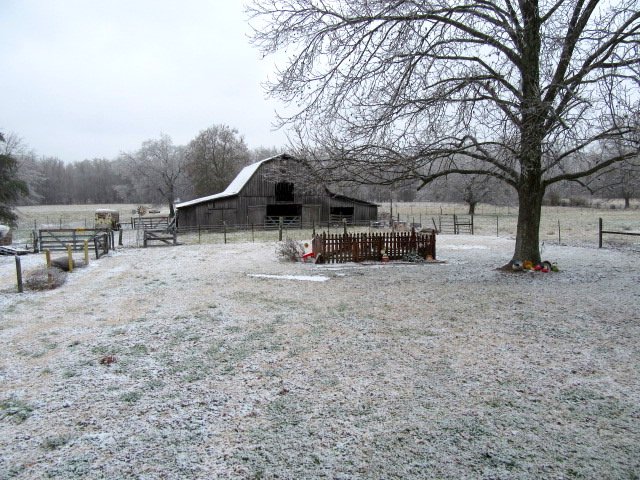
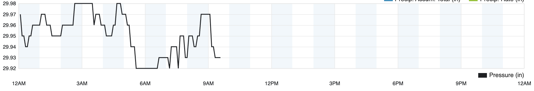
Good morning! Well, we got 4" of wet snow, our seventh visible accumulation snow event of the winter in southern Lincoln County 7 miles above Alabama, and our eighth winter weather event counting the ice storm, all in a "la Nina" year when it was forecast to be warm and dry. I also follow the signs of nature as well as the meteorology, and they pointed all autumn to this kind of active winter in direct contrast to seasonal forecasting. Annual snowfall averages for this place are < 1" normally. But tomorrow pivot day finally arrives. By Tuesday, we will be enjoying the low 60s for several days. Currently ground fog, 32, winds calm and barometer at 29.93 inHg. They say we may get some flurries but I'll bet if we get anything it will be rain.
-
February 17-18th Winter Storm Thread.
Sweetpea Farms replied to John1122's topic in Tennessee Valley
There was a heavy band of snow extending from Florence, AL, to Fayetteville, TN, and 3.8 inches predicted here in southern Lincoln County. I dunno, maybe at present rates, but it would have to be a long event. Rain allegedly will move in later tonight. Allegedly.
-
February 17-18th Winter Storm Thread.
Sweetpea Farms replied to John1122's topic in Tennessee Valley
So far, not snowing as heavily as predicted. There's about an inch on the ground in southern Lincoln County, 7 miles above the AL line. -
February 17-18th Winter Storm Thread.
Sweetpea Farms replied to John1122's topic in Tennessee Valley
Nothing here in southern Lincoln County yet but it is supposed to be cranking up sometime in the next half hour. Rates of 1+ inch an hour predicted. Currently 28 and calm. Camera atop the Severe Weather Institute - Radar and Lightning Laboratory at The University of Alabama in Huntsville. Might be fun to watch from there later. https://www.nsstc.uah.edu/swirll/cams/swirll/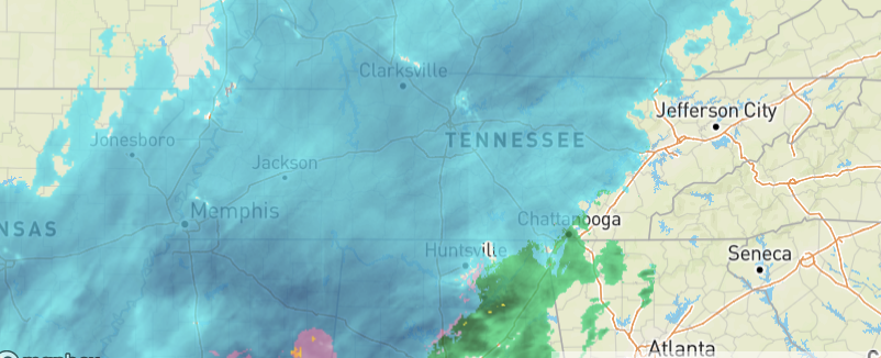
-
February 17-18th Winter Storm Thread.
Sweetpea Farms replied to John1122's topic in Tennessee Valley
WHAAA? I have been busy as a bumblebee today and I finally get to look at a forecast and it's for 3-5 INCHES of snow and ice in Lincoln County? Looks like models here support it, too. Ew.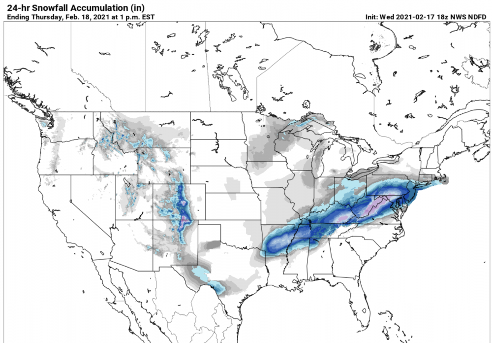
-
February 17-18th Winter Storm Thread.
Sweetpea Farms replied to John1122's topic in Tennessee Valley
It looks currently like a lot of models are lining up in agreement for this to maybe be a mostly rain event for me in Lincoln County, seven miles above Alabama. I sure hope so. All the best to others facing another sinter storm. It looks like we may not advance past advisory status on this one, as of now. Things will be clearer, of course, tomorrow morning. -
2/14- 2/16 Winter Storm and Arctic Cold
Sweetpea Farms replied to WestTennWX's topic in Tennessee Valley
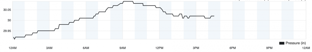
And it continues to snow even though the forecast calls for a sunny afternoon and the barometer is steady to slightly rising at 30.03. This reminds me of living up North when it would get cold and it just seemed the temp itself would sometimes wring not-forecast flakes out of the air. It's quite pretty to watch them float down here in Lincoln County, 7 miles above Alabama and 12 miles above the "no freezing rain zone" there. What a difference 12 miles makes! 19 degrees, no wind. -
February 17-18th Winter Storm Thread.
Sweetpea Farms replied to John1122's topic in Tennessee Valley
OK, I just looked at two pages of models (thank you all very much) and they say the same for Lincoln County as the present storm: Maybe, maybe not. Present forecast here is for snow showers with zero accumulation. That'd be fine! -
2/14- 2/16 Winter Storm and Arctic Cold
Sweetpea Farms replied to WestTennWX's topic in Tennessee Valley
NOAA says: "On average, thirteen inches of snow equals one inch of rain in the US, although this ratio can vary from two inches for sleet to nearly fifty inches for very dry, powdery snow under certain conditions." So ...1" divided by 2" = .50 times 13" = 6.5 inches. Or, 13 divided by 2 = 6.5 inches for those who, not being as mathematically challenged as I am, like the short way. -
2/14- 2/16 Winter Storm and Arctic Cold
Sweetpea Farms replied to WestTennWX's topic in Tennessee Valley
Still snowing on this sunny day! Getting a lil whiter. Seven miles north of Alabama in Lincoln County, it is a balmy 18 degrees , winds calm ENE, and 30.01 inHg on the rising barometer. So we should see an end to the snow soon.