Sweetpea Farms
-
Posts
60 -
Joined
-
Last visited
Content Type
Profiles
Blogs
Forums
American Weather
Media Demo
Store
Gallery
Everything posted by Sweetpea Farms
-

2/14- 2/16 Winter Storm and Arctic Cold
Sweetpea Farms replied to WestTennWX's topic in Tennessee Valley
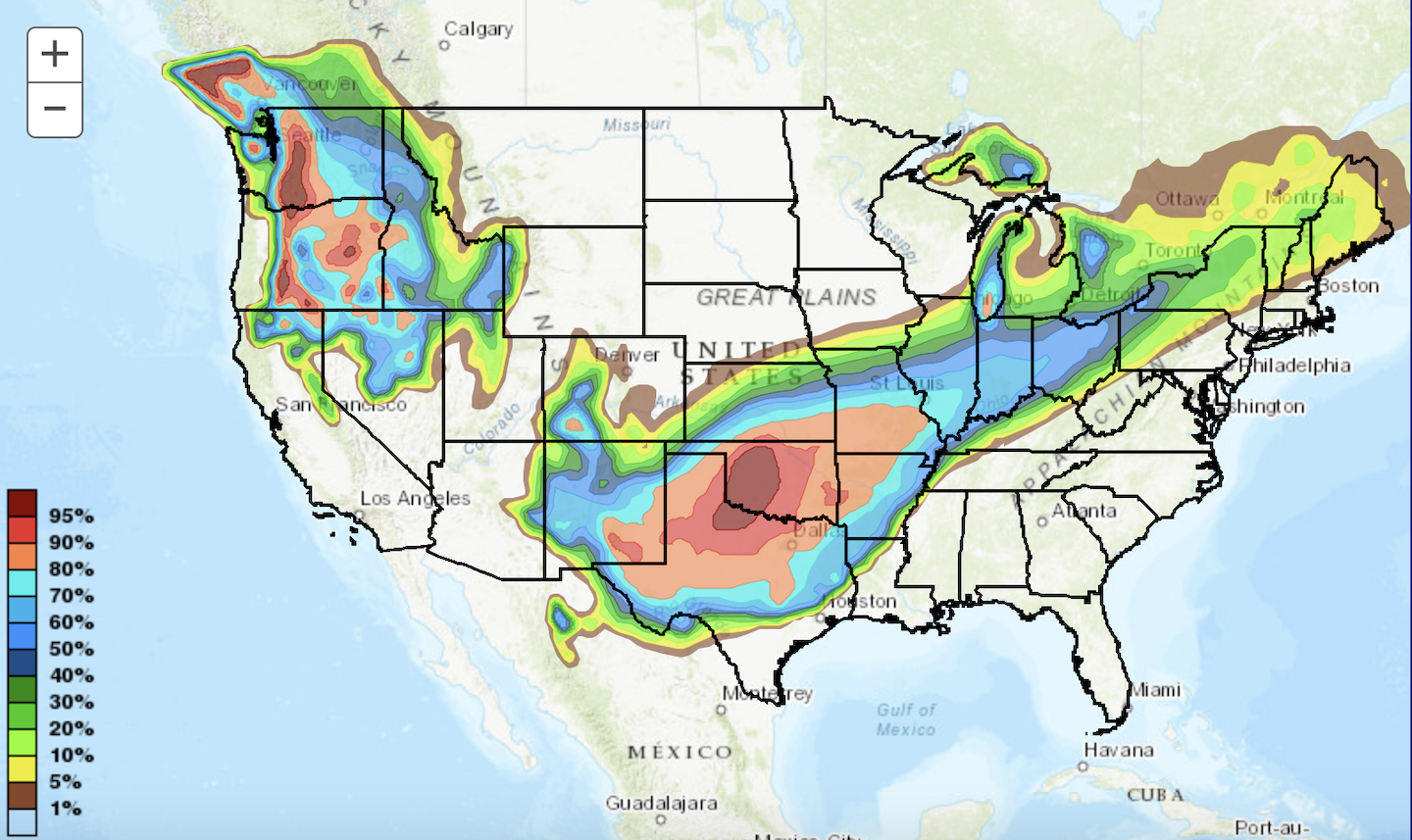
This must be the model they are using in my friend's area in coastal Louisiana, where they have been warning of a 90% winter storm chance for the past 3 days. At 7 miles above the AL line in Lincoln County, TN – well, I am all for it! -
2/14- 2/16 Winter Storm and Arctic Cold
Sweetpea Farms replied to WestTennWX's topic in Tennessee Valley
I agree with @david30 that it does appear it will be warmer along the storm frontal boundary than earlier forecasts. The track is also firming up as more northerly. Currently in Lincoln County, TN, 7 miles above the AL line: 29 degrees, wind NNE at 2-3. 0" precip overnight, barometer 29.92 inHg. Potential high 37. I had to sit down and slide myself off the edge of my porch this morning to get out of the house. The culprit: freezing fog, which is still present but not dense. Salt has been duly applied and the cows will just have to wait a few hours and a few degrees before they get hay. There's a positive to the weather situation that the cold-warm boundary this morning remains between Montevallo, AL, (38) and Montgomery, AL, (47). It has not moved farther south since it slid about 100 miles south overnight Wednesday to Thursday. That bodes well for better outcomes here along the AL state line in Giles, Lincoln and Franklin counties of TN. My farm remains on the edge of the "maybe" zone, so forecasts continue to vary pretty widely by source – between, as a TV meteorologist said last night, "figure out how you are gonna heat your house" to rain. Currently, Monday is forecast as rain or ice, depending on source. That is a dramatic improvement over yesterday (ice to snow with 3.6" accumulation) and the day before and it fits with my doubts about a full-blown snow and ice event, so I'm patting myself on the back right now while I can, because it all could change by this afternoon. The bulk of Monday's rain is now predicted between 11 a.m and 8 p.m when temps here are forecast at around 44, so freezing does not seem likely. A rainy day would fit what I thought would happen, so we'll see. Looking forward to "pivot day" on 2/19, when we will head back into the spring progression with highs going forward in the upper 50s and low 60s Just gotta get through this one spot here. https://www.wunderground.com/dashboard/pws/KTNFAYET29 -
2/14- 2/16 Winter Storm and Arctic Cold
Sweetpea Farms replied to WestTennWX's topic in Tennessee Valley
Forecast for Lincoln County, TN on the AL border has changed six times at least today... lol... Currently calling for light freezing rain early morning Monday then freezing rain later in the day moving to a wintery ice/snow mix after 10 p.m. I remain doubtful. The forecast has swung from all rain to rain to ice to ice to snow and back and forth all day. That's because my farm sits just about precisely on the southeastern edge of this massive cold weather system. Couple of degrees one way or the other will make all the difference for us. Current cold-warm line is between Montevallo, AL, south to Montgomery, AL. Montevallo is at 42, Montgomery at 56. Isobars favor the cold right now but the southern isobars are tighter than they had been earlier so it really could go either way for the Alabama border counties of Giles, Lincoln and Franklin, in Tennessee, as well as the greater Huntsville AL NWS District that includes Lincoln and Franklin counties. A very interesting thing to watch develop. NWS 12 p.m. CST Sunday to 12 p.m. Monday CST. This moves the snowfall just ever so slightly south of the earlier version.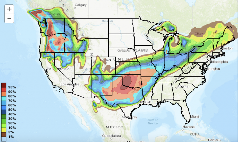
-
2/14- 2/16 Winter Storm and Arctic Cold
Sweetpea Farms replied to WestTennWX's topic in Tennessee Valley
It's currently locally predicted as ice to rain and then back to ice overnight on Sunday, then ice to snow Monday accumulating to 3.6 inches in Lincoln County, TN. That is 1.3 inches higher than yesterday's forecast. But this whole period is squirrelly (and fun) to forecast. The NWS prediction map follows exactly what happened about a week ago when we were definitely gonna get slammed with major storm out of Arkansas. It went north. Fine by me, as I have had my doubts about major winter storm activity over my area since this last potential threat arose. I've thought the southern warmth will rise just enough to mostly push it north, though parts of NW Tennessee will see some winter weather. Plenty of time for that scenario to evolve. It sure would make feeding my cattle easier. Go NWS! We'll see... -
2/14- 2/16 Winter Storm and Arctic Cold
Sweetpea Farms replied to WestTennWX's topic in Tennessee Valley
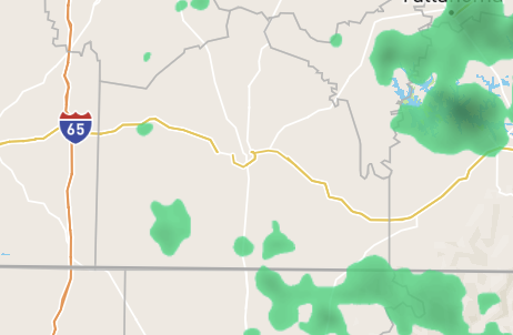
Huh.... This NWS snowfall forecast for 12 Sunday through 12 Monday contradicts our local weather predictions in the greater Huntsville, AL region including Giles and Lincoln counties of Tennessee by quite a bit.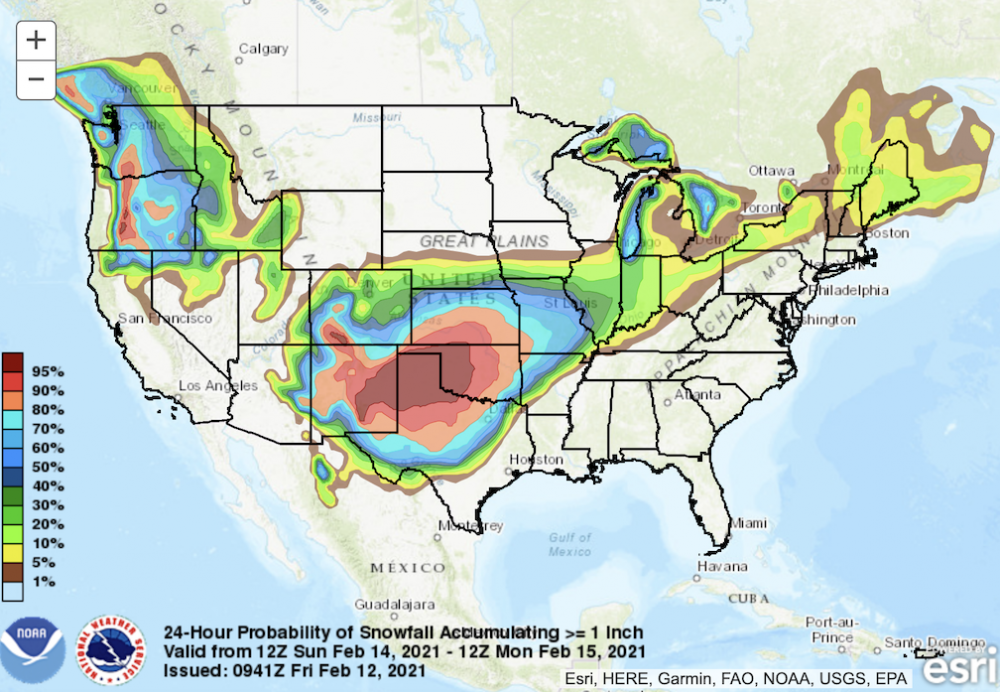
-
PPT on Forecasting including free links
Sweetpea Farms replied to wdrag's topic in Weather Forecasting and Discussion
Thank you! -
2/14- 2/16 Winter Storm and Arctic Cold
Sweetpea Farms replied to WestTennWX's topic in Tennessee Valley
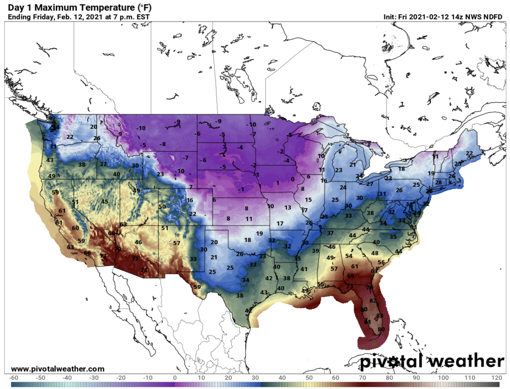
In southern Lincoln County, seven miles above the AL line, 31 degrees and ground fog. Winds E at 3, and man, that fog plus the wind made it chilly out there this morning at 7 a.m. Barometer 30.01 inHg. As I suspected, our future forecast for the southern border counties in TN bordering AL is changing quite a bit since about 8 p.m. last night. Then, it looked like all rain overnight Sunday and then snow starting Monday after Noon. Right now in this model, Sunday night looks like ice to rain, changing to light ice overnight. Then Monday starts out ice to later snow with 3.6" total accumulation (about 1.3" more than last night's guess). I know there will be further changes in the outlook as we get to Saturday night. For me, it sucks if this happens, as I was due in Huntsville, AL, for a COVID vaccination on Monday morning! Right now, you have to go all the way south to near Montgomery, AL, to find a warming line. Montgomery is 49 now and going to 56 today. By the time you go north to Pelham, it is 40 and expected to be 46. We just had a similar model of a winter storm brewing over Arkansas that was gonna sweep across Tennessee and north Alabama, but it wound up traveling well north of us with a warm air push. Still time for change. We'll see what happens. What do you think? This map seems dated to the high side on temps for our area already.
-
2/14- 2/16 Winter Storm and Arctic Cold
Sweetpea Farms replied to WestTennWX's topic in Tennessee Valley
Right now it is 37 in Huntsville, AL, 46 in Scottsboro, AL, and 50 in Fort Payne, AL. Quite the boundary in just 68 miles. Huntsville TV weather is saying ice is coming Sunday night but I still have my doubts as of right now. I think it could literally go either way depending on the boundary. It IS changing as we go. Some forecasts are shifting right now to wintery mix (snow/rain) for Monday only. It's a hard one to predict!
-
2/14- 2/16 Winter Storm and Arctic Cold
Sweetpea Farms replied to WestTennWX's topic in Tennessee Valley
This is exactly what I've been watching and I am hoping we get a push from the south to keep this from being as nasty as it looks right now. Plenty of time for change yet. Right now it is 36 where I live near the northern AL-southern TN border but you only have to go to Birmingham AL and it is 53. Come on, southern oscillation! PUSH! -
2/14- 2/16 Winter Storm and Arctic Cold
Sweetpea Farms replied to WestTennWX's topic in Tennessee Valley
My first post. No thunder overnight in southern Lincoln County, TN, seven miles above the Alabama state line. Hit our high of 49 at midnight. Been mostly 37 since 7 a.m., and 36 degrees now with wind NNE at 4-9 but swinging around to the west and even the north, and barometer at 29.87. Rainfall so far 0.46", way below the 1 or 2 inches predicted. We had no really heavy rain and no ice. Thankful because we formerly were in the target zone in long-range forecasting. I have been looking at the ice storm models for Monday-ish. I dunno, it is a maybe thing IMO. If you look at temps to the south of us in Alabama, they get quite high quite fast. It will depend on how strong that warm push is, whether ice can accumulate or we just get a cold rain or pellets. I am due 25 miles away in Huntsville on Monday so I hope it is indeed rain or the ambient temp has been high enough that the ground is warm enough to prevent road freezing. Otherwise, could be a fun ride! For a week now, it has looked to me like 2/19 could be called the "pivot day" for this event, at least in southern TN and north AL. After 2/19, I think the trend should be to warming and I think we should get into the 50s and low 60s in the central southern TN border counties during the last week of the month. 2/18 and 2/19 themselves could be dicey with maybe wintery-like weather. But I still think once we get past 2/19, we should get on track to some genuine springlike conditions. Slightly misty out currently but the rain clouds have left my county for the most part. I doubt we get much more accumulation.