Owensnow
-
Posts
134 -
Joined
-
Last visited
Content Type
Profiles
Blogs
Forums
American Weather
Media Demo
Store
Gallery
Everything posted by Owensnow
-
I like 3-7 here
-
Ohhhh this looks yummy this time! Classic look for DTW and XHA
-
4.5 here total wind was impressive with heavy rates but too transient.
-
If that last banding holds quite possibly Computer models aren’t handling the convective snow accumulations very well
-
Full on blizzard here now incredible
-
Complete whiteout convective snows +SN and more
-
Man some of these convective snows in Kingsville are just crazy. The NAM 3km shows some serious returns after 2Z
-
HRRR is the worst case for TOL The NAM and RGEM offer support for a solid event in TOL, possibly even thunder
-
HRRR is worst case for me, snow 23-01z then dry, then sleet fest, then back to dry snow till midnight. NAM 3km and 12km has potential thunder snow after 2z here. RGEM has snow from 23z to 6z Just not liking the proximity of that northward marching dry slot
-
Not to mention look at the erosion in the snow shield already from the dry air intrusion yikes.
-
HRRR really pushing the dry slot party all the way up to DTW. heavy snow is from this gonna be further west than projected. Going to switch to snow here after sleet and then dry slot, then back to sleet again it might finish with two or 3 inches on the ground here east of TTF Wow Gotta say the models have been all over the place with this thing and the northwest trend has once again proven itself fatal for me I think hope I’m wrong but radar really doesn’t resemble anything decent for this neck of the woods later on.
-
Have a look at that dry slot headed for IN I think DTW is in trouble here I really do
-
Man looks like DTW and TTF are going to be walking a fine line here between wasting half of the storm on sleet and whatever. modelling solutions are stronger and further north west. might even get into a dry slot for a time“ according to the latest Hi-Rez NAM but looks to be convective snows in the tail end deformation area. Still not overly confident on snow amounts from Detroit and South
-
Check the radar in SW MI you can see it mesoscale low has an eye like a tropical storm
-
still SN here and HIGH winds! Love it HRRR and NAM 3KM keep the snow here till 05-06z lol For sure came more NW
-
Same here now, really picked up in SN since 8AM.
-
SN here since 8AM HRRR and RGEM keep me there till 03Z
-
3-6 inches here today, inside the north edge of the 2nd wave till 03z according to the RGEM and HRRR Maps show 5-6 @ 10:1 but assuming 16:1 or so???
-
Switched over from RA here at 4pm right to +SN and awesome ratios right away
-
LOL no clue, just like the one at the top, all i know is I have been watching these climb steadily since 9Z
-
TTF
-
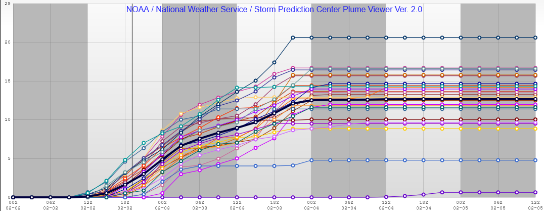
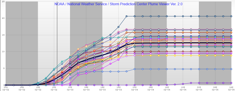
Plumes back up to 11-17 inches at TTF just south of DTW and north of TOL on the western shore of lake Erie
-
I think we are good. HRRR and RGEM still keep snow through tonight and likely all day tomorrow.
-
Keeps it snowing right through 6z Friday at TOL and MBY
-
I find some calm from your statement. Thoughts on TOL and points NE to me across from there in Kingsville ON?