

Owensnow
-
Posts
134 -
Joined
-
Last visited
Content Type
Profiles
Blogs
Forums
American Weather
Media Demo
Store
Gallery
Posts posted by Owensnow
-
-
Precip will end within next hour or two down here. there will be nothing left from the earlier snow I bet.
-
Back to snow rain mix
-
1 minute ago, michsnowfreak said:
1 hour after rain and mix turned to snow. Yesterday's snow was all melted, so this is all new.
same thing here, inside of the last hour we’re almost at 2 inches
Really concerned about that dry slot coming up from Ohio
-
Temp dropped from 39 to 35 last 30 min
SN+ now wtf
weird storm
-
10 minutes ago, mississaugasnow said:
has it started down there yet?
Pouring white rain only
-
Umm HRR cancels the snow for us and far SEMI
RA
next please
-
2 minutes ago, Lightning said:
Not much to say really. It's all Chicago area right now. We play the waiting game. To be honest my excitement and expectations are just hoping to somehow get 6" out of this. Models are so so on that.
Models are maintaining sub 0 850s through the rain period. Any ideas why that precip is modeled as rain? showing rain for 4-5 hours.
For sure a waiting game but need faster arctic intrusion to cool things in the column or we are getting rain I think
-
14 hours ago, Stebo said:
Oh yeah totally love it. At this point I'm just going to stop talking about this storm because the minute I say anything it blows up in my face. Congrats Chicago
Yep, another one in the books for SEMI and SW Ontario i am afraid. Slush and then rain and then frozen hell with nothing good on the ground.
-
2 hours ago, BigHoss48192 said:
Another year...and probably another season of busted storms for SE Michigan. It's 34-35 out and not even raining but the radar shows that it's snowing outside. Must be evaporating before it even hits the ground. Nothing to see here....
Same over here (north shore of Lake Erie) not a single flake. Next storm is looking better but weel see I guess. Sad.
-
1 minute ago, nwohweather said:
Why wouldn’t you expect it to trend NW over time? It’s a strong, deepening low that wants to go poleward. The sampling that has been done IMO has allowed the models to produce a more realistic solution.
I’m still concerned about the dry air intrusion in that second window, would not be shocked at all to see QPF impacted from the possible MDT risk event occurring in the Gulf Coast regionNot saying that wont happen, what if the cold is underdone? Anyways that does not answer my question, forgive me but what factors should prevent a SE shift?
-
Wonder when the models will pick up on the dynamic cooling?
What is preventing this from moving SE again all?
-
can someone please explain to me how it is that almost everyone of these events quits halfway through the forecasted event?
Woke up this morning, and it was snowing very nicely, and now already reduced to pixie dust with supposedly five more hours to go?
-
 1
1
-
-
1 hour ago, michsnowfreak said:
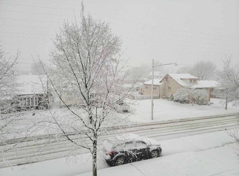
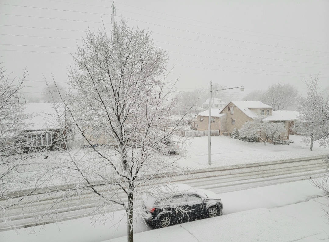
It never gets old waking up and opening the curtains to a fresh Winter wonderland. It's really coming down and it's absolutely gorgeous outside. Nearing 4 inches already.

Amen to that
The discussion out of the Detroit office this morning was less than hopeful for the higher end amounts, but they seem to be under doing those?
Edit… radar is already drying up
-
1 minute ago, SolidIcewx said:
It’s crazy how it went from puking flakes to a rain shower under the heavy returns
Same
had red returns earlier with snow but not +SN. Then went to straight rain. Drove 10 minutes west and there was 1-2 inches down but already went to rain.
-
5 minutes ago, Stevo6899 said:
You're further east into Ontario, the snow was modeled to stop pretty much near the can border.
yep
making observations and I will point out that the HRRR does indicate the possibility of rain all the way to Detroit.
-
 1
1
-
2
-
-
1 minute ago, Stevo6899 said:
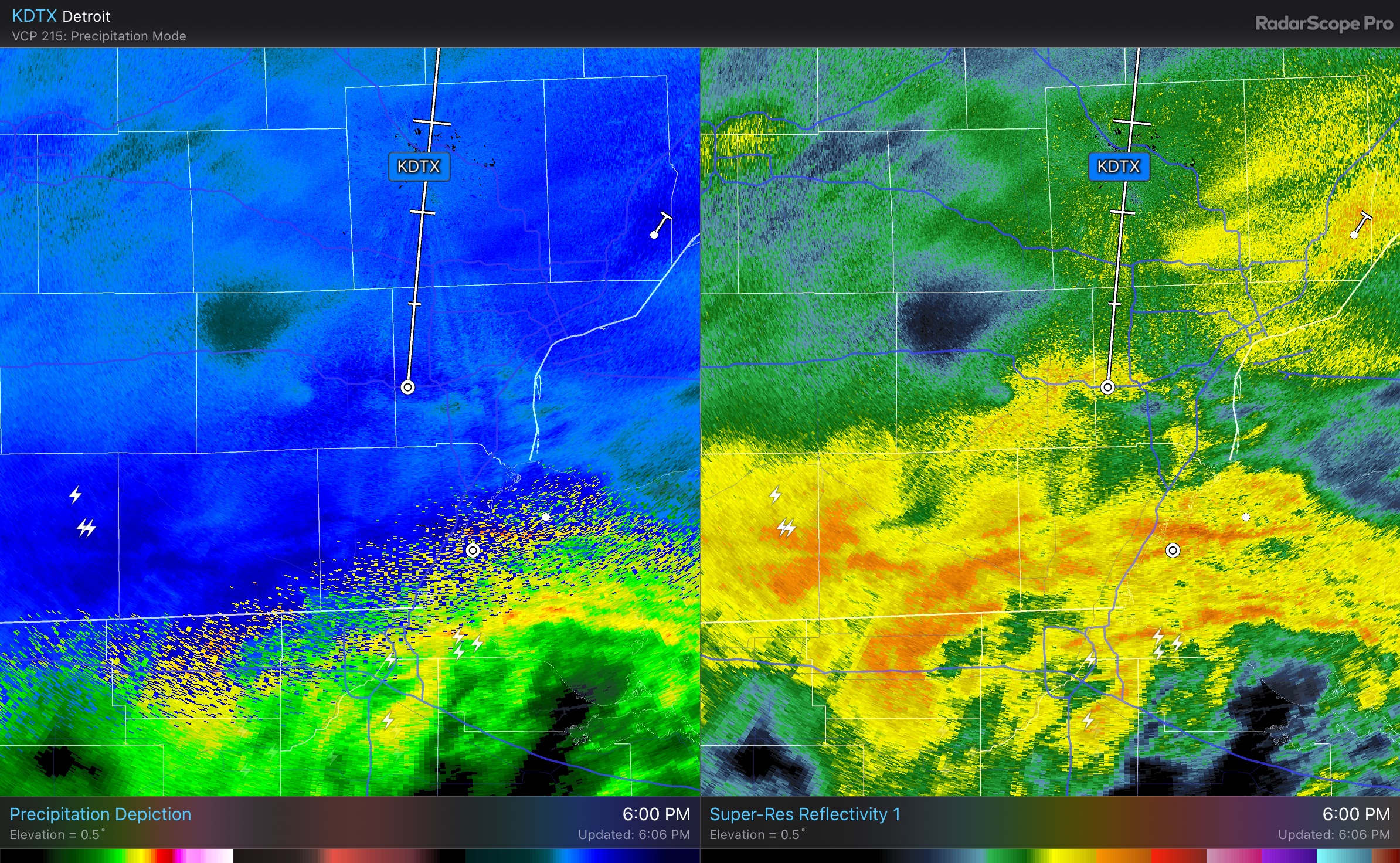
Is that yellow banding on the radar south of Detroit sleet mixing in?
more than likely rain that’s what happened to me
-
absolutely ripping rain here
If HRRR has its way, we will barely see another flake from this event.
-
2
-
-
1 minute ago, SolidIcewx said:
Detroit metro about to go to pound town
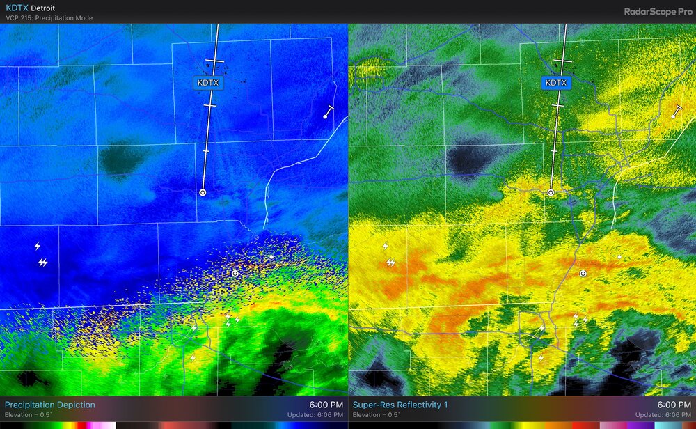
Those returns marked the end of the snow for me. Wind came up after that and wham, back to rain. Models nailed it. No snow here again till after 9PM now according to most. The riverfront areas of MI look to end up the same way?
-
1 minute ago, SchaumburgStormer said:
Guys. Look at this grey. FUCKING INCREDIBLE!
god I’m so salty about this one.

Same
wind and rain here now
all done for now
-
1
-
-
3 minutes ago, HillsdaleMIWeather said:
It's filling in, and the really heavy stuff is coming from the SW
Yeah HRRR shows pretty decently the screw zone once again
-
hard rain here
radar says +SN but just rain
-
1
-
-
18 minutes ago, DAFF said:
Leamington for me, during the winter. On the Shores of Erie just a few doors before the entrance of Point pelee.
I see,
Not sure what we will get here, usually these scenarios are rain / sleet but the precip rates will be very high so who knows
Huge bust potential to our west with any changes at all
-
4 minutes ago, michsnowfreak said:
Still nervous about rain/sleet, but also excited. Could be some insane snowfall rates!
Well, to be honest this is what NAM 12z thinks IMBY and I am Kingsville Ontario, just SE of you. 2 M 850 SFC SFC 700 6 HR 500 1000 TMP TMP PRS RHU RHU QPF HGT 500 (C) (C) (MB) (PCT) (PCT) (IN) (DM) THK FRI 7A 03-MAR -0.1 0.7 1014 93 21 552 541 FRI 1P 03-MAR 1.8 2.8 1005 83 94 0.00 550 546 FRI 7P 03-MAR 0.7 -2.3 990 97 98 1.00 541 550 SAT 1A 04-MAR 0.5 -4.5 992 95 69 0.48 536 543 SAT 7A 04-MAR 0.9 -4.4 1008 94 64 0.01 542 536 SAT 1P 04-MAR 2.3 -2.0 1014 92 26 0.00 548 537 SAT 7P 04-MAR 0.7 -1.0 1018 98 86 0.00 548 534 SUN 1A 05-MAR 0.6 -3.5 1020 98 86 0.00 545 529-
1
-
-
So for us non informed weather weenies would I be right in saying this stays snow here?
12Z NAM for XHA (Harrow Ontario, Canada)
2 M     850     SFC     SFC     700    6 HR     500    1000
                 TMP     TMP     PRS     RHU     RHU     QPF     HGT     500
                 (C)     (C)    (MB)    (PCT)   (PCT)   (IN)    (DM)     THK
FRI  7A 03-MAR  -0.1     0.7    1014      93      21             552     541
FRI  1P 03-MAR   1.8     2.8    1005      83      94    0.00     550     546
FRI  7P 03-MAR   0.7    -2.3     990      97      98    1.00     541     550
SAT  1A 04-MAR   0.5    -4.5     992      95      69    0.48     536     543
SAT  7A 04-MAR   0.9    -4.4    1008      94      64    0.01     542     536
SAT  1P 04-MAR   2.3    -2.0    1014      92      26    0.00     548     537
SAT  7P 04-MAR   0.7    -1.0    1018      98      86    0.00     548     534
SUN  1A 05-MAR   0.6    -3.5    1020      98      86    0.00     545     529


Did Someone Say Clipper(Hybrid)!?! 1/18-1/19
in Lakes/Ohio Valley
Posted
zero inches here
sugar since maybe 4:30 that’s it
this one was a dud for sure