.jpg.7212c88cd7a6ee918250d4a9d2a8d183.jpg)

Chicago916
-
Posts
211 -
Joined
-
Last visited
Content Type
Profiles
Blogs
Forums
American Weather
Media Demo
Store
Gallery
Posts posted by Chicago916
-
-
3 hours ago, Chicago Storm said:
you new to spring in chicago?Nahh. Just enjoying my daily couple hours of heat before free AC.
-
Backdoor cold front (and daily lake cooling) gonna suck.
-
Posting if allowed and if anyone didn't know it was ongoing. But a fun discussion on NOAA from some big names in weather.
-
 1
1
-
-
10 minutes ago, HillsdaleMIWeather said:
The Stormtrack Discord which is ran by conservative Mets shut down discussion on the nws mets getting fired
Something something wokeness
Was scrolling through that earlier. Lots of cringe. Quite a few "oldtakesexposed" on Twitter as well.
-
1
-
-
47 minutes ago, DocATL said:
Are we interested in the GEFS snow mean or nah?
Only mean SCP
-
 1
1
-
-
Patiently waiting for the 18z Euro to load up and for someone to happily or sadly post it...
-
1
-
-
Just now, A-L-E-K said:
Is it too much to ask for a couple more bumps? Fully sampled now so no surprises but the trend actually feels like a trend not intra model wobbles.
Feels like the next model run is make or break. Lately that's where model downtrends have started and continued. Fingers crossed.
-
1
-
-
28 minutes ago, michsnowfreak said:
i always root for anything to benefit us. I dont really care about the northeast unless it affects us directly. Most of the east coast has been in a far worse snow drought than us the last several years. The glory days when the lower Great Lakes and northeast were getting season after season of above to well average snowfall and it was always "f*ck boston" and stuff like that is now about a decade removed. Just. Give. Me. Accumulating. Snow.

Yeah I feel that. Just would love to be able to root for something at this point. It does look like we'll stay active through the end of the month with storms traversing our region. Hopefully some pan out!
-
1
-
-
At least this next potential storm we can all just root for better phasing and negative tilt to benefit us all and possibly screw the Northeast?
-
1
-
-
1 minute ago, TheNiño said:
Flakes have already started here on the lake at the Kenosha/Racine county line.
Can clearly see developing radar echos on the Illinois side too from LOTs radar. Now we wait to see where the main plume develops and sits!
-
2
-
-
5 minutes ago, Chambana said:
I feel like the bastard child right now. Although, the jackpot is likely to miss by 25-50 miles to my south. HRRR annihilates Champaign though.
As an alumnus of UofI and living there many years and not getting much snow, I'm rooting for ya!
-
Looks like next weekend we get disappointed again. Good trends lately for a more northerly storm as supposed to a Southern Slider, but too far out.
-
1
-
-
Bullseye in my backyard, lock it in (0z RGEM)
-
1
-
 1
1
-
-
1 hour ago, A-L-E-K said:
currently riding the canadian obv
I'm genuinely curious what post storm temperatures would look like in the Chicagoland Metro compared to outlying areas due to a hypothetical snowpack from this scenario.
-
6 minutes ago, A-L-E-K said:
Riding Canadian fantasy les, the usual
It's the only way to get double digits in the city these days. The lake taketh, but rarely giveth.
-
1
-
-
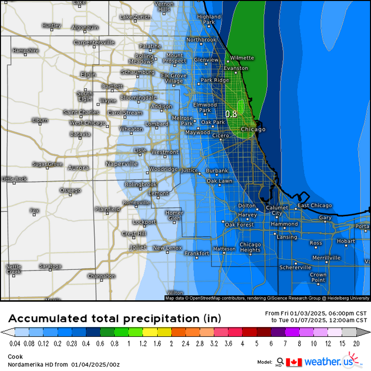
Maybe at least a miss South will lead to some significant lake effect snow in NE IL as seen on in the Euro already and now seen on the Canadian model? Would be a nice consolation prize. Hate to have to rely on that though.
-
2
-
-
Were the latest European and Canadian ensembles showing an improvement the nudge needed to start this?
-
2 hours ago, Chicago916 said:
It has no other model support but enjoying the hi-res models' unrealistic snow profiled runs for the NYE storm
Seems like the last couple runs of the GEFS are starting to hint at some minor accumulations now. Decent accumulations in MI.
-
1
-
-
It has no other model support but enjoying the hi-res models' unrealistic snow profiled runs for the NYE storm
-
1
-
-
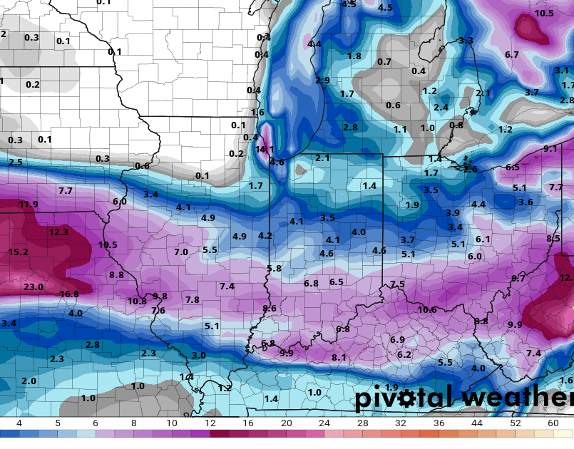
Definitely some better trends lately for a snowy next couple of weeks? Seems like the mean trough position has shifted slightly west putting the GL and Midwest into a more favorable position. I'm not putting much faith in a large storm before the Arctic blast though, too much ptsd from the last time we saw that in modeling and got blizzard warnings for a glorified cold front. We'll see though, tons of moving parts.
-
2
-
-
Odds the pattern change brings Cutters west of our region, followed by Northeast storms and we're left in the dust?
-
1 minute ago, A-L-E-K said:
p impressive ensemble mean for 270 hours

will be a challenge to see organized snow in the region anytime soon imo
Better odds of thunderstorms?
-
All jokes aside the trend is still good for the late week clipper. With some kind of lake enhancement, maybe someone in WI or IL will get 3"+... I guess some will take it before the huge torch and given how un-wintry things have been. Would be nice to even see fantasy big dogs again in models.
-
1
-
-
Funny to see the Wednesday trough keep trending West and slightly more negative. Too late for most of our Sub for a thread the needle on that system though. Maybe you guys in Ohio can somewhat cash in.
-
1
-
5/15(northern half) & 5/16(southern half of subforum) Severe Wx Threats
in Lakes/Ohio Valley
Posted
Don't agree with LOT?