
MPotter_WX
-
Posts
70 -
Joined
-
Last visited
Content Type
Profiles
Blogs
Forums
American Weather
Media Demo
Store
Gallery
Everything posted by MPotter_WX
-
I can attest to that. Hellertown still dumping.
-
4” in Hellertown. 2-3”/hr rates ongoing.
-
1” approximately in Hellertown. Winds making it difficult to measure
-
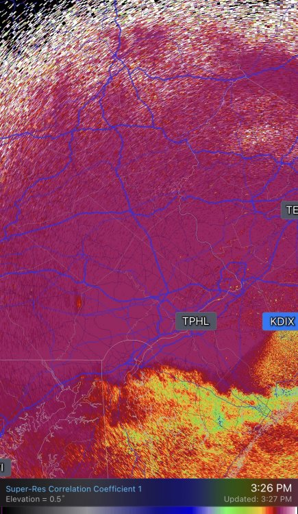
There’s the dreaded mixing line rearing it’s ugly head on KDIX
-
Light snow with 1 mile visibility here in Hellertown. Getting my popcorn (and beer) ready for the heavy stuff in an hour or two.
-
Light snow dusting up all surfaces not treated in Fogelsville. Heading back to home base in Hellertown. Sure doesn’t feel like a mixed event.
-
LV is a bust should the NAM and 3K NAM pan out. HRRR holds onto my thinking this morning. I hate mixed events
-
My final call for LV is 8-12” south of Rt. 22 and 12-16” north of Rt. 22. Still room for a shift either way, but this is my highest confidence forecast. Hopefully we can all enjoy a show at least from 4-10p.
-
Looking over the NAM, the main lobe of vorticity at h5 was definitely displaced to the SE compared to 12z. May see that shift SE in all models this evening. The mixing/dry slot will continue to be an issue, but any move SE is good for everyone.
-
Honestly, this should have been the forecast this AM...
-
I really think Mt Holly should not have jumped so high for SE PA. It’s always better to raise totals later. Even though that HP is strong, it’s seems evident mixing with end up being an issue for many of us. Still holding out hope LV stays all snow but sleet may ruin our accumulations as well.
-
Definitely liking the NAM trends. Cannot complain after the last couple of seasons. The combination of mixed precip and/or dry air cutting off steady precipitation is going to create a HUGE gradient across the region.
-
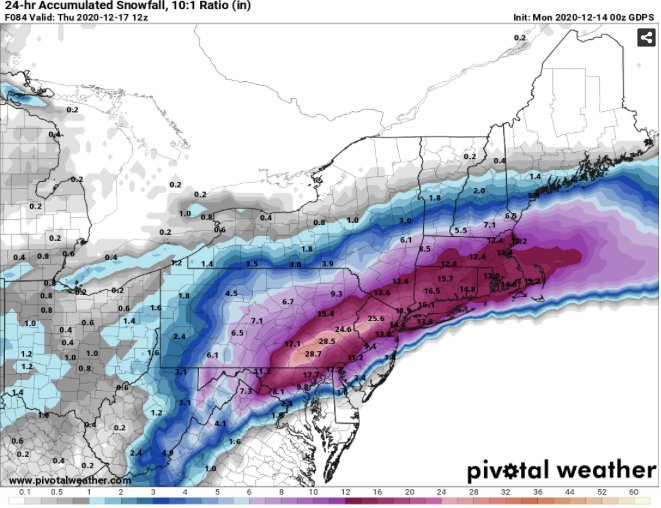
Dumping snow here in the LV Wednesday evening with this depiction from the latest 18Z NAM 3 km. But that dreaded dry slot is quite close...
-

December 14th Rain / White Rain /Wet Snow obs
MPotter_WX replied to ChescoWx's topic in Philadelphia Region
Had 1.0" here. It was quite clumpy on the top so I had to average out the measurement. -
On Twitter I saw a sensitivity analysis showing the implications of latent heat release within the downstream ridge. Has a lot to do with how the NAM is so amped (overdoing convection) with the GFS is so flat (under-doing convection). Guess we’ll see who can handle the convection better.
-
Canadian shows a jackpot of 24”+ for the LV! I’m good if we can stop here, haha.
-
GFS is much more suppressed and keeps the UL vort more disorganized. Good hit for SE PA with no mixing. Doesn’t even have 12” for the LV.
-
Timing seems to be set for start early afternoon on Wednesday
-
Look no further than the 2016 blizzard. Had it nailed from the get go
-
Definitely getting excited here in the LV! Looking like at lock of at least 12”+; however, I am a little wary of mixing with sleet should enough warm air filter in aloft if those trends N occur. The strength of the confluence/1038-mb high is a saving grace for this event. The position of the coastal low will ultimately decide the fate of you guys to the south, so keep the faith. As is typical of all of these systems, once we get a good sampling of this system once it makes it to the west coast (12z Monday), we should have a good handling of its position.

