
Ephesians2
-
Posts
296 -
Joined
-
Last visited
Content Type
Profiles
Blogs
Forums
American Weather
Media Demo
Store
Gallery
Posts posted by Ephesians2
-
-
16 minutes ago, RIC Airport said:
Been a while since we've been screwed this bad.

NAM was showing basically nothing 24 hours ago, right? Also, from what I've heard it tends to have a north bias.
I think it's an improvement and definitely better than where we thought it be going a couple of days ago.
2-4" with some sleet and ZR will stick around a while with the advertised temperatures. I got 4" with the second Jan 2022 storm, including an inch of sleet, and it stuck around for two weeks with warmer temperatures than what we are seeing on models.
-
 1
1
-
-
5 minutes ago, Jersey Andrew said:
Does this storm have an analog?
Jan 2019 seems the closest, at least that I can think of.
https://www.stmweather.com/blog/current-events/winter-storm-january-11-13-2019
-
2
-
-
16 minutes ago, SnowenOutThere said:
As someone who is that age I don’t remember anything much before 2016 besides glimpses of storms. I vaguely remember the 2016 blizzard but wish I could recall more about it. The Monday system may be the first time I can truly remember getting 10+ inches of snow (ig Jan 2019 counts too but yk what I mean)
I was in Fredericksburg for Jan 2022 and got 15". Other than that, the only 10"+ storm I remember clearly is the 2016 blizzard.
I have very vague glimpses of the 2009-2010 winter despite being 7 years old then, because I was a weather nerd, my parents got me a 3-year weather observation book for my 7th birthday

-
4
-
-
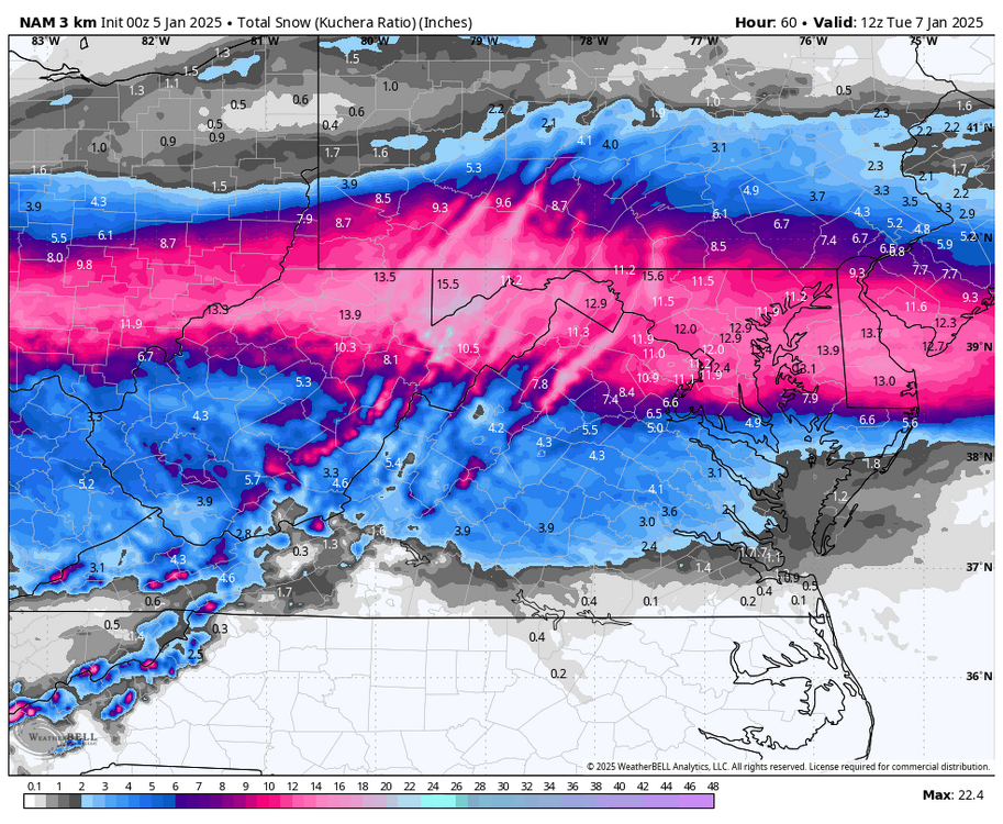
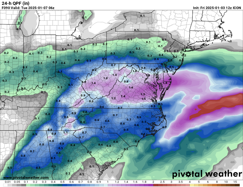
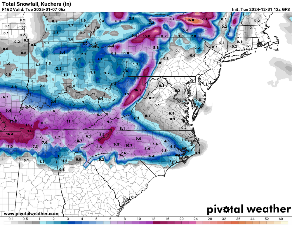
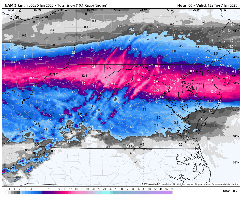
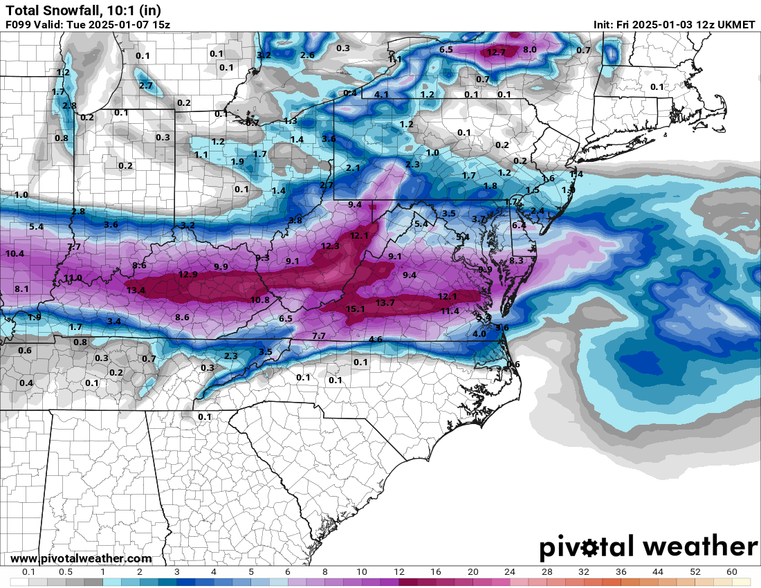
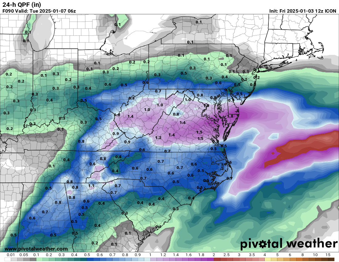
CMC is a step in the right direction as well. Confluence further south. Snow jackpot and QPF max now over Fredericksburg, not DC. Verbatim, not exactly what we want in Central VA, but it's an improvement - the 6" line is roughly from Charlottesville to Hanover County. I'm liking these trends.
-
GFS went slightly south. Not exactly where we want it - but an appreciable shift.
-
1
-
-
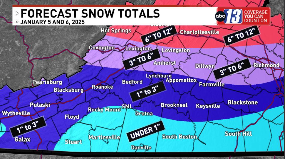
FWIW ... map from local Lynchburg TV meteorologists
-
3
-
-
The GFS does not cave. Going to be virtually identical to 12z. Also significantly drier than other models.
-
1
-
-
On the other hand, the RGEM looks like a *slight* step back, but basically unchanged (mostly sleet/ice with 1-3" in Central VA). It's a DC/NoVA jackpot with the 6" line near Fredericksburg
-
ICON is a significant improvement and gives Richmond area some snow from the Coastal as well.
-
2
-
-
NAM isn't great, but an improvement. It brings some snow into Central VA, but still mostly sleet/ZR. Hoping it's overamplified as I've heard its bias is.
-
2
-
-
Just got a nice squall in Lynchburg - quick coating on grass and car tops. Not in the forecast from NWS or commercial sites.
-
1
-
-
Flurries in Lynchburg.
-
1
-
-
-
UKMET is beautiful - south of 00z. R/S line south of Richmond the whole event.
-
It looks like a very wet run as well. This would be a lot of sleet south of the immediate DC suburbs, and significant ice in Central VA
-
-
17 minutes ago, Buddy1987 said:
Nam is the Nam but I will be interested to see what it shows with CAD after seeing the Canadians output from last night.
I hope we can get a couple of inches of snow before the flip to ice. If so, it will definitely stick around a while.
-
1
-
-
24 minutes ago, Ephesians2 said:
Let's hope we don't lose the GFS completely.
We did - it's going to be heaviest DC north. Verbatim - it's mostly an ice event in Central VA.

-
 1
1
-
-
Let's hope we don't lose the GFS completely.
-
I don't want to post this in the main thread because they didn't like the run, but this doesn't look bad for Central Virginia at all with the standard medium/short-term north trend, and with other models like the ICON and Euro with the jackpot in DC area.
-
3
-
-
3 minutes ago, SnowenOutThere said:
Gfs with a quick hit on the second
Looks like 1-3" with fairly marginal temperatures.
-
The snowstorm of March 2-5, 2026, was an extraordinary late-season weather event that brought widespread disruption to the Mid-Atlantic and Southeast United States. Following an otherwise average winter with near-normal temperatures, the storm emerged from a significant shift in atmospheric patterns. The North Atlantic Oscillation (NAO) sharply dropped, resulting in a blocking ridge over Greenland. This pattern supported the stalling of a cutoff upper-level low, which interacted with a slow-moving surface low-pressure system. As the storm meandered over Alabama, Georgia, and North Carolina before stalling off the Outer Banks, it created a unique setup for prolonged and intense snowfall across the region.
Temperatures during the storm hovered near freezing, creating a perfect environment for heavy, wet snow. On March 4th, snowfall rates of 2 to 4 inches per hour were recorded across Virginia and Maryland, making travel nearly impossible and leading to widespread power outages. The Washington, D.C. area experienced significant snowfall, with totals of 12.6 inches at DCA, 18.1 inches at IAD, and 16.2 inches at BWI. The heaviest snow, however, fell in a corridor stretching southwest of D.C., from Roanoke and Lynchburg, Virginia, to Winchester and Hagerstown, Maryland. Another secondary maximum extended across southern and eastern Maryland into southern Delaware. Augusta and Rockingham Counties in Virginia reported over two feet of snow, tying records set during the historic Blizzard of 1993.
This snowstorm's impact was particularly severe due to the timing and intensity of the snowfall. With spring nearing, many areas were unprepared for such a significant winter event, amplifying the disruption. The storm not only highlighted the unpredictable nature of late-season winter weather but also underscored the importance of atmospheric dynamics, such as the NAO and upper-level blocking patterns, in shaping regional weather extremes. In the aftermath, the Mid-Atlantic and Southeast faced days of recovery, as residents worked to dig out from the heavy snowfall and return to normalcy.
-
4
-
 1
1
-
 1
1
-
-
Sleet with a few mangled snowflakes in Lynchburg, maybe a trace of accumulation on grassy/elevated surfaces. This wasn't in the forecast for us - was supposed to be all rain. 33/31.
-
7
-
-
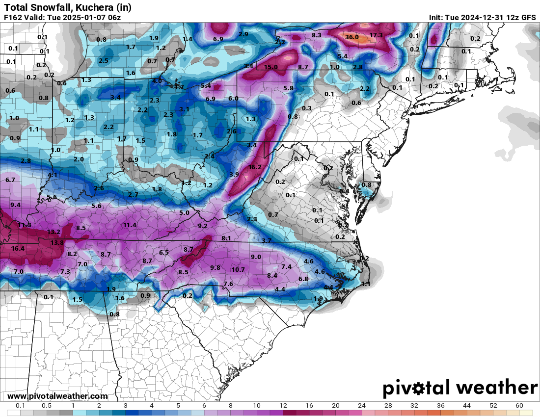
BWI: 4.1
DCA: 1.3
IAD: 3.0
RIC: 5.5
Tiebreaker (LYH) - 7.0
-
1
-


Richmond Metro/Hampton Roads Area Discussion
in Mid Atlantic
Posted
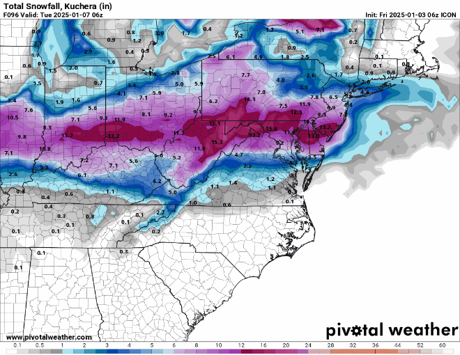
RGEM ticks to the south and bumps up QPF - 11.1" at RIC on Kuchera. It's a tight gradient just south of there though.