
IowaStorm05
-
Posts
1,486 -
Joined
-
Last visited
Content Type
Profiles
Blogs
Forums
American Weather
Media Demo
Store
Gallery
Posts posted by IowaStorm05
-
-
3 minutes ago, 78Blizzard said:
That looks a lot different than this:

Like Robert Stack says..... UPDATE! :
I can see where that one dude talked about how warm air gets easily pulled into the town of Windham

-
2 minutes ago, NeonPeon said:
Population distribution.
I guess most of us are in CT or Coastal Massachusetts, and it isn't looking that sweet for coastal peeps on this one.
-
14 minutes ago, tunafish said:
As depicted, the goods don't make it to MBY. Outliers at this point, but curious regardless.
It looks like you will do about as well as me. Virtually every single model run coming out right now is offering me 5 inches.
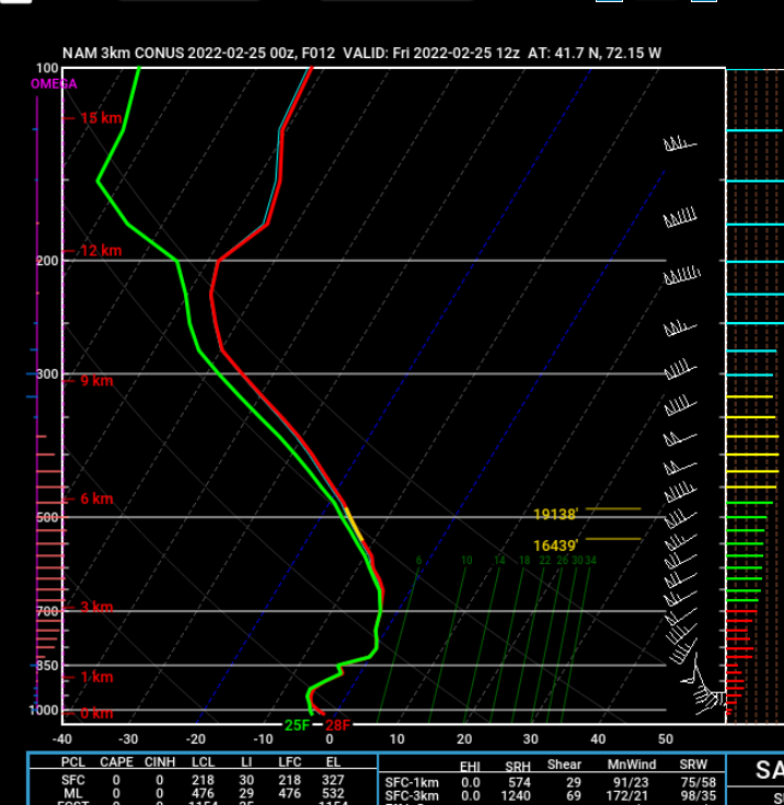
As far as 00z NAM 3k is concerned, it's straight to rain for Groton.
And as far as 00z NAM 3k is concerned, Willimantic is RIGHT on the border line for plowable snow here. I checked all the soundings for each hour, and the air aloft does not breach 32 degrees until 13z. Shows a rainer as close as 10 miles to the south. Fortunately, this is the worst model run for this event for my spot. It is not that likely to verify.
-
1 minute ago, Lava Rock said:
I'm nearly back to grass so not interested in starting over, not that it would last long anyway, which also dampens the spirit. Unless its 12+ this point in the season its not real exciting for me
Sent from my SM-G981U1 using Tapatalk

-
 1
1
-
-
1 minute ago, tunafish said:
LBSW for us up here. OUCH.
I'm sorry, but I don't understand what that means.
-
7 minutes ago, moneypitmike said:
I will also say that this is the most dead night of commentary 5 hours before the flakes fly I've ever seen.
I noticed that. Why?
I mean this is a significant storm that just happens to be poised to disappoint my state.
-
So I am going to get 3 or 4 inches of snow.
-
9 minutes ago, Sugarloaf1989 said:
This is the wrong location for decent snowfall.
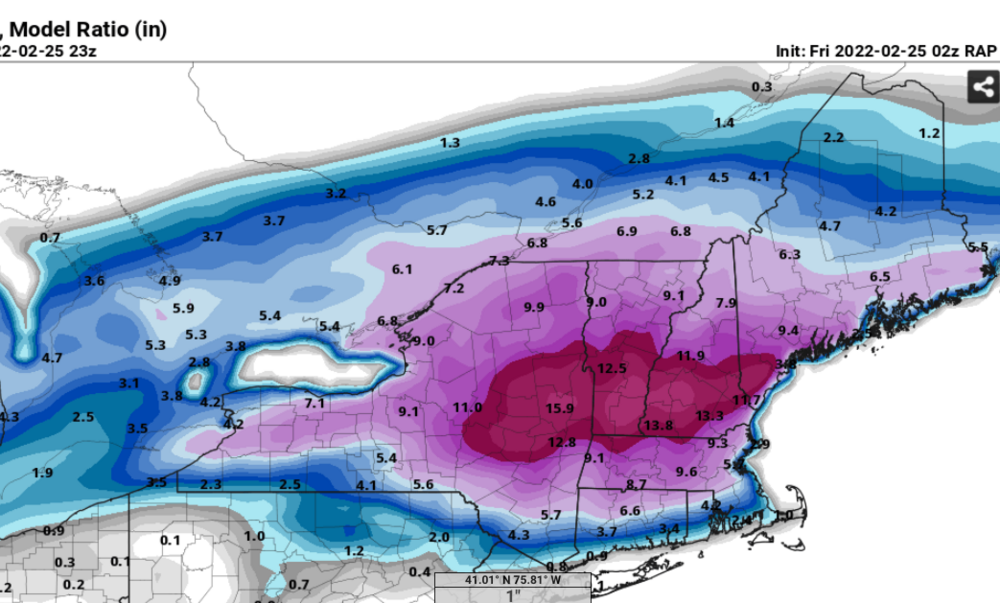
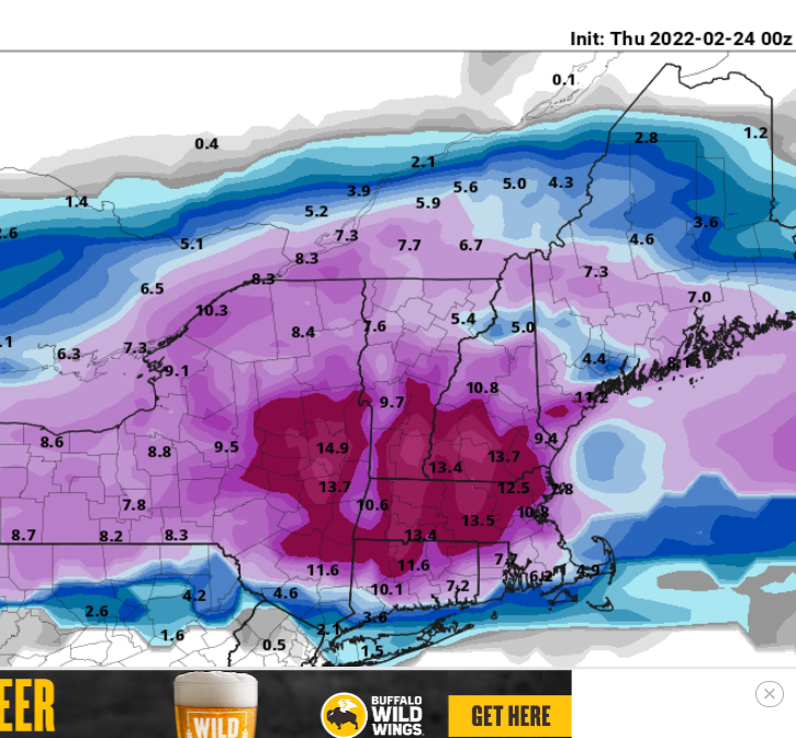
00z RAP
-
 1
1
-
-
I was just thinking of Japan when someone posted about it last night.
I was thinking how Japan has some similarity to New England's winter climate... It is on the Northeast coast of a major continent, thus drawing cold continental air masses that come into contact with the ocean.
But the obvious difference is that ocean effect snow, since New England is not broken off of the main continent like Japan.
New England is notoriously snowy compared to the rest of lower-elevation American continent since it features the maximum of the fetch of upwind cold air mass, meeting the ocean from where moisture is upwelling from the Southwest. Could you imagine if New England had a 100 or 200 mile stretch of ocean located where the state of New York is? Places like CT might not take the most advantage as they may be a little bit too far south and warm most of the time. But once you get up to a Maine latitude, or add a few thousand feet of elevation, all bets are off.
-
2 hours ago, PhineasC said:
Glad I don't live there.
You shall be sent to spend your winters in West-Central Kentucky.
-
1
-
-
1 hour ago, Damage In Tolland said:
I’ll tell you the main reason is because the NAM keeps cooling. Run after run, . Typically once it warms at mid levels , it never stops. So to me.. that tells me the colder solutions are likely to win out
Short term models returned to and are sticking to quite cool solutions too. They are not having it. I don't know what will happen honestly but I can tell you this: It felt bone chillingly cold on the coast in CT tonight.
-
 1
1
-
-
2 minutes ago, CoastalWx said:
Wow at 12z, the 18z NAM has a wicked 850 front near the south coast. Going to dump in that 12z-15z...whatever precip falls.
It is exceptionally warm
-
6 minutes ago, RUNNAWAYICEBERG said:
So I assume the sounding an hour or two later (which can’t be seen) would look better before the warm nose pokes us again?
This really has been a lot of north trending this past 12 hours, and gravitating toward NAM and RGEM solutions following their stubborness.
it is my hope there is still a chance for a last-minute "correction" southward again. I know we are still going to get in on some of the action, but it is nothing like the 8 to 12 inch ideas that were on the table last night.
Otherwise my worst-case idea last night of sleet tamping down amounts badly all the way up to 10 or 20 miles south of the MA border might be more of a reality.
-
GFS has decided that winter storms drop their precipitation in a pattern of Octagons.
-
1
-
-
4 minutes ago, dryslot said:
Couple tics north on the 12z GFS.
The trend is screwing CT and the result of the losses I am going to be made to travel in nasty weather instead of enjaying hot cocoa by the radiator in my pajamas.
-
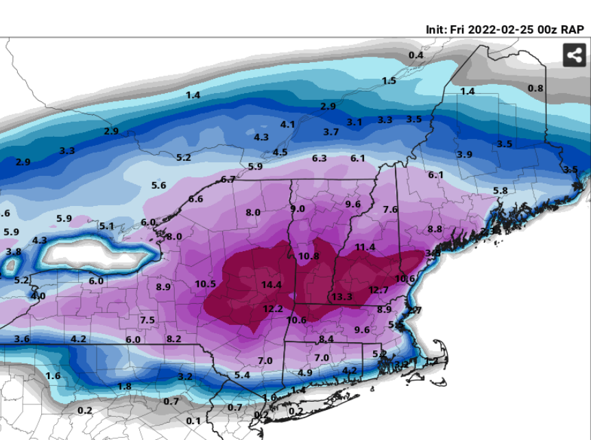
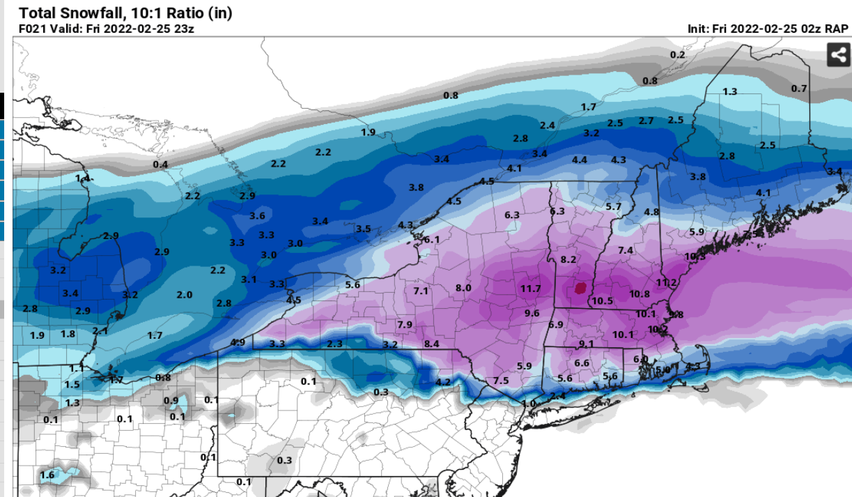
14z RAP still serving it up for papa
but it is quiet on here right now.
-
06z was trouble, just maybe not as bad as it looked at first, considering RGEM and NAM were the first two things I looked at in the AM just now.
And Soundgarden? When I heard that Soundgarden / Audioslave guy died, Chris, I was pretty sad. So talented and I just felt like it could have been avoided.
-
-
Just now, 40/70 Benchmark said:
My wet dream run?
Maybe.
I was actually going to say it looks kind of stingy around these parts though.
-
7 minutes ago, wxsniss said:

Hi! Can I ask, What is this?
-
4 minutes ago, George001 said:
What’s the farthest north you guys think this can go at this point?
In Connecticut, I think the furthest north a mix of sleet That significantly tamps down on snowfall accumulations could get at this point would be maybe 15 miles south of the Massachusetts border.
-
 1
1
-
-
00z GFS is nice. Disclaimer it is Kuchie. The thought is turning to the wonder if Upton would soon become compelled to extend warning down to the CT shore.
-
1 minute ago, wxsniss said:
re: 0z RGEM... it's almost identical to 12z... 18z was the colder oscillation
ie., not sure I'd read 0z RGEM as a significant trend vs. noise
I was thinking about this. Against the backdrop of other 00z models so far, I think it is mostly noise. The thump on the immediate coast isnt even really much different
I just saw a 10 mile reduction in southward sag of ~6 inch amounts.
-
2 minutes ago, PhineasC said:
NAM cut back hugely up here. This is becoming a nothingburger for NNE. Enjoy the snow SNE.
I will have to wait a little longer.
You get April deals.

Winter storm for the 25th of February is imminent.
in New England
Posted
One has to wonder what it is that prompted models to have a 10 inches to the coast frenzy last night in the first place, only to pull the rug out under by this morning. It is never a good feeling to wake up and see the snow line scalped up over the forehead of CT.
And the Russia thing really bothers me and freaks me out. I do a lot of study of Chimpanzees, who have extremely similar coalitions, and the fore-planning of invasions and war... The behavior of taking other peoples land by murder and force is most definitely in our genes, and so is the prevalence of alpha-male authoritarian rule. The behavior of human war is nothing of surprise. It is shared by most other primates. These traits are not in my blood however, which is of course why I am a lower-ranking male.