
IowaStorm05
-
Posts
1,486 -
Joined
-
Last visited
Content Type
Profiles
Blogs
Forums
American Weather
Media Demo
Store
Gallery
Posts posted by IowaStorm05
-
-
9 minutes ago, dendrite said:
NAM wise...early on looks like the northern stream is a little slower digging in for the phase. Not much change with the southern stream.
That is BAD
-
00Z HRRR at 26 hours out.
I see a tiny “screw zone” over what I think is the Willimantic River. But that’s probably a resolution “artifact”, not a revelation of elevational disadvantage and 26 hours is fairly far out still for this tool..
but the focus of this here is that it brings heavier totals allllll the way down to coastal locations... sparking the idea that SOMEWHERE in coastal CT or RI could get action if they’re lucky
-
35 minutes ago, Typhoon Tip said:
Sort of... graupel is partially refrozen aggregate pieces ...which is sort of the same thing .. but those under thundersnow/CSI banding...they are larger and really do appeal as though they were suspended by updraft for a period - graupel is snow falling into an incomplete melting layer. The end result may be similar but not quite, and also different formation sequencing -
But alas ...many of these process in this crazy business in reality share processing/physics so ... the seams can be rather "cloudy" - haha... puns are free by the way -
I feel like it’s more common in the inter mountain west, and areas in the Great Basin.
the most common time I would see graupel in Reno, it would be in late winter/early spring during weak disturbances, where the sun was stronger, and you’d have partly sunny days with scattered quasi-convective “snow showers”. Sun would heat up ground in shallow ways, then a snow shower comes in, temp at surface drops from 50 degrees to 30-35 quickly with lots of graupel.
-
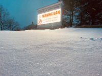
Will be interesting to see what this does for Willimantic.
we are at the southern part of the better amounts in models and watches but we are at about 250 feet elevation. Has to count for something right?
-
Just now, It's Always Sunny said:
Anyone else think NWS is underdoing BDL?
They might be just waiting for more consistency/consolidation. Newest runs are bringing BDL into the action....
they only just issued watches for Tolland and Windham...
-
12 minutes ago, Typhoon Tip said:
I almost wonder ...
Sometimes in thunder-snow ... you get these 'pingers' that aren't really clear like sleet, but are mangle aggregated refrozen thumpers along side of the "normal" aggregates. - Its something I routinely noticed when amid the fall column out of a snowing thunderstorm -
I'm wondering if it's similar to what you are describing... to being 'in the top half of a CB cloud' ... interesting - like aggregates are getting UVM blasted and caked into clusters - hail seeds if you will...
I think it’s called “graupel”? We got it all the time in Reno, NV and yes it’s quite an origraphic/vertical motion and lapse rate kinda deal
-
2 minutes ago, Spaizzo said:
All of ct? Holding onto hope
Immediate Coastal areas of eastern CT and RI probably still mostly miss out but even these areas could get a 2 inch cementing if lucky
-
-
Just now, ORH_wxman said:
I made a map of it years ago for SNE
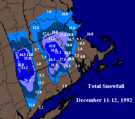
Looks like that gap is all due to the warming effect of the CT river and lower elevation!?
-
 1
1
-
-
-
1 minute ago, TauntonBlizzard2013 said:
I still think this has a shot to pound even if for a short time down this way.... even a few hours could put down a few inches
So for SNE this potential has to do with how far south and under the wrap around gets then yes? Seems like the Canadian, which hasn’t been wisely discussed has held down pat on not providing any wrap around for most of SNE.
Yeah it’s also a matter of position S N E W too of course
-
7 minutes ago, 40/70 Benchmark said:
I flipped just after midnight...maybe 1am. I remember jumping on the NOAA weather radio and hearing that ORH already had 1' when I had just flipped.
Forecast began at 4-8" for me and kept going up. Ended up with 18". I had never seen snow like that to that point in my life, having grown up in the 80s.
The most remarkable transition that I ever saw is also my first meteorological memory...the March '84 storm. I recall that the changeover was so distinct that I could see it sweep across the neighborhood looking out the window.
Reno, NV has the most picturesque transitions I’ve ever seen. There, transitions are vertical IE snow levels, and snow always accompanies fog with very low visibility. Growing up on a hill, transitions have the appearance of a ceiling that gradually lowers itself down the backdrop of the sierras to its west, into the valley. As a kid, I could tell you what the current snow level was just by seeing the location of that ceiling.
-
Just now, STILL N OF PIKE said:
Mine as well wait till the Euro comes out
Mine as well go for a soda.
Mine as well face it.... you’re addicted to love.
-
4 minutes ago, Snowcrazed71 said:
So do you guys think that the National Weather Service will put some watches up in to Connecticut now?
Willi here.
I doubt it. I don’t think there’s enough consistency in models up through now and as I pointed out the Canadian has been steadfast at showing rain here... while other models have started trending toward it.
it’s possible we could get last minute warnings but meh. It’s more likely we would see a couple inches of snow in northern or northwestern counties
-
10 minutes ago, Chrisrotary12 said:
Canadian looks like rain?
It has... and if this warmer solution verifies One could point out we aren’t exactly in an NAO negative right now...
the Canadian has been most consistent of em all the whole time.... I feel like, predicting a warmer soltn
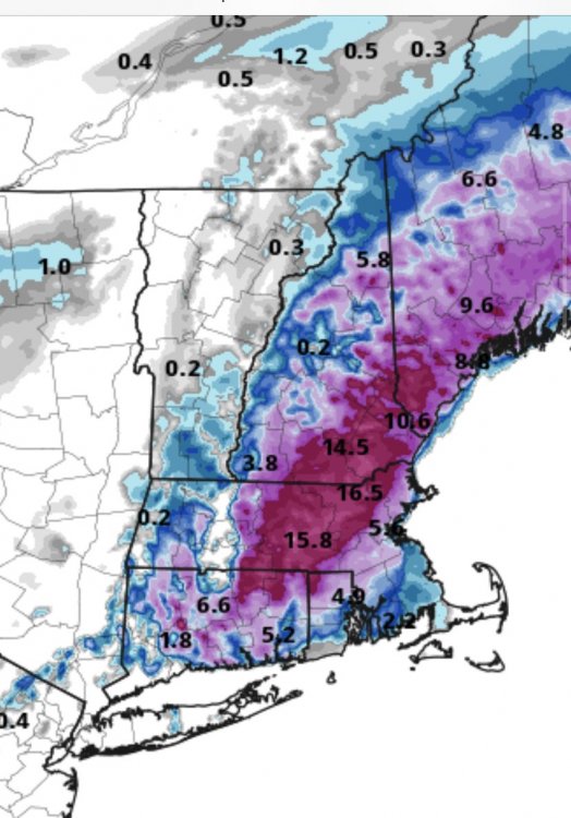
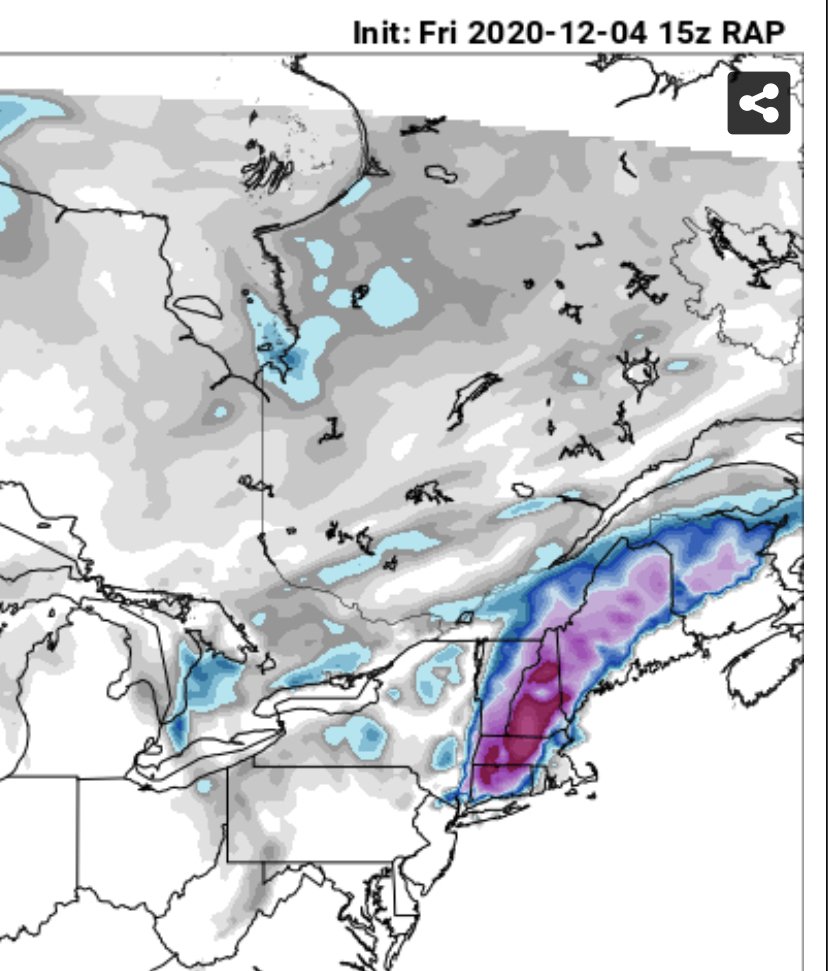
15z RAP looking great for CT but I don’t trust it for 30 hours out
-
 1
1
-
-
1 minute ago, crossbowftw3 said:
:sad:
It still wouldn’t surprise me if it trends back slightly south or East later today or tonight. But really nothing would surprise me at this point, but yeah it’s also looking too toasty for comfort here now.
But these trends definitely verify folks yesterday who were disregarding the 18z runs as likely bogus.
-
24 minutes ago, RDRY said:24 minutes ago, RDRY said:
I'm aware of that. Over two decades up here seeing when watches are issued, I found the call to be oddly out of sync with the modeling. It requires much more forecasting certainty at that lead time to issue watches in these parts. If the mets making the call simply anticipated an outcome divergent with the modeling, they've never referenced it in their write-ups.
Yes they are out of sync, and in addition they have to anchor themselves with consistency in their forecast packages against wildly shifting models IE yesterday’s MA watches being issued while several models wanted to remove snow from that area and shift focus onto Maine.
furthermore, central and eastern NWS offices has to prepare the afternoon package before 18z model runs come out anyway so from our perspective it can look like 18z is being ignored.
-
1
-
-
Not exactly promised for Willimantic.
but it could!
-
Just south of UCONN here
Was loving the 12z runs for these parts... 18z squashes that excitement, albeit at least we still have a better shot than, say, Waterbury.
if things “adjust” a bit westward for 00z we’d be likely to get a few inches.

December 5-6, 2020 Storm Observations and Nowcast
in New England
Posted
Willimantic, CT here.
started experiencing light rain and showers in the past couple hours, temps been slipping into the upper 40s