
IowaStorm05
-
Posts
1,486 -
Joined
-
Last visited
Content Type
Profiles
Blogs
Forums
American Weather
Media Demo
Store
Gallery
Posts posted by IowaStorm05
-
-
But the RDPS crushes
-
Just now, PowderBeard said:
3km puts the low further south than 12km by a good 100 miles through the Carolinas. Anything to read into?
Could be off but if anything it adds “mental insurance” against a Ptype issue on the coastal plain of SNE
-
It’s raining
-
I’m even more interested in upcoming GFS and others. NAM not yet inside 48hr for SNE. Yet 12z NAM is more forgiving for coastal plain than its 06 predecessor.
-
3 minutes ago, JC-CT said:
My Compaq Presario is...still running the calculations
And 1998 was precisely the first year I started reading the forecast discussion. “ETA”. And the site was the shape of a map of the state and it had “Iwin.whatever”. I was in middle school. It WAS on a compaq presario!!!!!
-
 2
2
-
-
My reaction to GFS changes


-
1
-
 3
3
-
-
Do people like the Canadian anymore?
-
Just now, JC-CT said:
Just wondering how long you've been there
Not very long, I have a lot more time spent living near i95 in CT or RI
-
1
-
-
3 minutes ago, JC-CT said:
Are you from Willi, or in school there?
Yes but I’m not in school I’m disabled.
-
 1
1
-
-
1 minute ago, SnowEMass said:
Yeah don’t come too north now lol
I’m telling you that sh*t creeps me out even though I’m 30 miles inland now and it has happened more often in my memory than ticks south.
-
1
-
-
10 minutes ago, Snowcrazed71 said:
Got this from " the other forum "
Just reading the info from the NWS tells me the GFS is way off on ts representation of this event. Not so much track but the intensity and precipitation field. We have wondered why the precip just dies out and @StretchCT, @Phased Vort and @MaineJay all have pointed out the weakening of the system. However the NWS is saying this is a developing and intensifying system. tells me the GFS isn't in its right mind and we can expect a giant run either tonight's 00Z or tomorrow when it gets back on track. We may be seeing those incredible numbers it was spitting out Friday night and early Saturday again. So I think we are going to see a huge GFS run that actually makes more sense in the next 24 hours or so.
And since sampling is going to happen overnight or tomorrow It stands to reason that if any substantial changes occur in the forecast of this storm, they’d be more likely to show up overnight tonight with the 00 Zulu runs? Or later than that?
-
The Monday night CT deal not looking so great anymore
-
2 minutes ago, Fozz said:
The GFS really doesn't want to give in, any time soon.
Not only that it deviates even further
I have the queer mental twist that it’s action now provides some kind of bad insurance against the likelihood of a sweaty south coast
-
29 minutes ago, Greg said:
Make sure you read the Weather Report posted by Henry's Weather and the Weather Service Boston. Even they indicate a taint potential for the Cape and Islands can happen in certain tracks closer to the coast but still be off shore.
I have on multiple occasions seen early indication 3-4 days out of blockbuster snow on the coast and cape, then as we get down to 2 days out it turns out a mix of rain and snow along 95. A Valentine’s Day 2007 storm was an infuriating example of this. All my roommates cared about was the price of the new PlayStation 3. We ended up with a thin veneer of crusty ice with that air pocket under it.... IE quasi freezing rain.
Another was an early 2002 storm that promised 2-4 inches of snow on south coast. It never changed over to snow.
Granted, I feel like there must have been some improvements to forecasting since 2007?
-
1
-
-
8 minutes ago, ORH_wxman said:
Yeah it was similar but definitely a little bit squeezed compared to 00z.
I get that everyone is dying for a huge system, but people need to remember this is like 90-96 hours out still. We’re not even using the NAM/RGEM yet...it feels like this should be about 48 hours out given how long we’ve been tracking it but it still has a long ways to go.
Never any guarantees but I still like the idea of bumping a bit north given the deep shortwave associated with this.
Long ways indeed, though the degree of model consistency at this point is noteworthy in my view.... but yeah. Things bad could happen to it
-
19 minutes ago, Bostonseminole said:
why do you even post during the winter? just post during summer months.
I generally disappear from here in the summer, except for a few cumulonimbus or lightning posts when I lived in Iowa
-
Just now, Ericjcrash said:
Wrecked
I have witnessed over the years a lot of coastal storms trending too far south a few days out. They tick nw until the cities are in rain, especially I-95.
-
1
-
-
And the 12z Canadian is holding steady for us
-
After years of watching and following my less-than-pro opinion is that I feel like this would tick north because of the larger scale pattern at hand.
Of course I think that!!!! Because I’m in Central CT
-
1
-
-
6 minutes ago, raindancewx said:


Big happenings in my former home, Des Moines!!
-
9 minutes ago, PhineasC said:
MD has been cursed for snow lately. I assume it has to give at some point, but odds say the storm shifts far enough north to give Randolph more than central MD. It won’t take much for my house down there to be 34 degree rain for the duration. An “tic” or two would do it.
I feel like, and have seen some climate related articles and maps, that we are far enough in the bag of global warming that it has really started showing results in places like coastal mid Atlantic and southern New England over the last decade or two, but especially recently.
one report I saw in recent years indicated the coastal plains have been more strongly affected by global warming than interior or continental locations, if you believe in that. I’m no expert but I am just reporting my observation
What’s behind it or where it’s headed in terms of centuries or long term global climate is not my forte, but I’m talkin’ in terms of current decade type trends at the very least
-
11 minutes ago, Typhoon Tip said:
We've talked about this 'conditioning' aspect many times in the past but yeah... Those of us that remember the scorn and spurn 1980s ... a 6-10" was a juggernaut.. We had more than a few storms that decade that were billed as ... " the biggest event since 1978' " and well, I guess 10.4" was in fact the biggest event since 1978 until 1992 or thereabouts...
Oh right - yeah..... I guess Cape Cod got clipped by a couple of whitecanes but ... don't get me started on 1987's debacle January that year - the famed 4th period blizzard warning that verified partly sunny in 6 F cold while the Cape was denuded of all life...
Anyway, those that came into sentience since that decade which ..probably is a considerable population of this type of social mediaspheric engagement frankly .. they don't realize this handing foot deep snow event out like Pez dispensing is unique to this ... auh... maybe it's a climate change thing - I dunno. But it's not the way anyone older than maybe 33 thinks as normal -
If you're a 24 year old you only have donut stuffing machine with just a few bad winters... And that's what's interesting about the wind 2000 era: two of the worst winters I recall happened since 2000, ...in an era where I've 300 % more snow than I remember spanning decades prior -
I feel like too many people forgot about the great blizzard of 2005. That’s the one storm I know of that competes with the blizzard of ‘78. I’m 36 years old; it’s the biggest storm of my entire life. I was a “dandy” 20 year old, I spent it with lots of friends and we had one of those gallon jugs of table wine for it!
I was in Providence, and we got roughly 3 feet. -
5 minutes ago, Typhoon Tip said:
I'm the one who said that to him back then by the way... Out of the mouths of babes and onto television --
Yeah, that storied storm - you're talking about December 2003, 5-7th ?? - That had a bitter cold air mass packed into eastern Ontario. I remember the cold exerion down the coastal plain/damming and burier jet ... just insane. Enough that it sandwiched the CF all the way down in, ..well, almost to Sandwich.. Exaggerating to make the point here but it was like 42 F at the Sag. bridge and 22F more 5 miles west of there - something like that. I know it was 19 F up where I was living in Winchester Mass at the time ...which is actually S of Woburn down I-93 ...
I think we got 18" of pow pow out of that and managed a bare ground x-mass - haha
That 12/5-12/7 was definitely a memorable couple of hits for SNE.
what happened in the few weeks following? Basically those snows were followed up by a change to rain and milder pattern, however I recall that the snowy coastal deal returned nicely once we entered 2004.
-
4 hours ago, ORH_wxman said:
You basically get a ridge bridge now at about D5-7. That is a good thing.....
The -NAO going forward is nice too...especially since the N PAC isn't that good once we're about D8+....the NAO can really help put a system or two underneath us on that scenario.
Yes negative NAO IMO is a really big deal I think. It’s not strong rn but it’s way way better to be in this pattern looking ahead than November/December 2006. That autumn was the WORST!

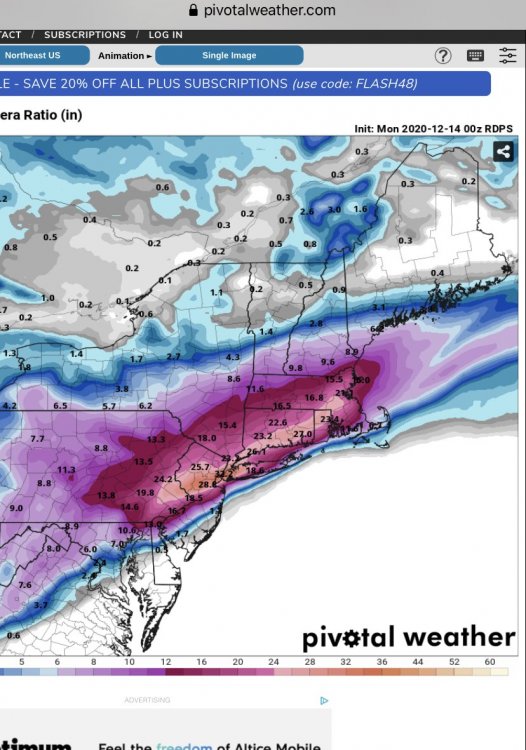
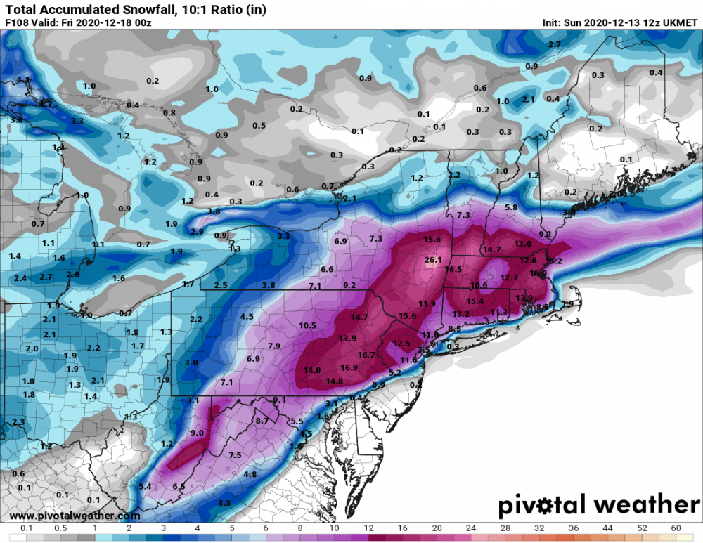
Active mid December with multiple event potential
in New England
Posted
Moderate if you’re in Truckee California hehe")