
IowaStorm05
-
Posts
1,486 -
Joined
-
Last visited
Content Type
Profiles
Blogs
Forums
American Weather
Media Demo
Store
Gallery
Posts posted by IowaStorm05
-
-
1 minute ago, JC-CT said:
The GFS is increasing the likelihood of Pope embarrassment by a factor of "a lot"
If ya wanna talk about embarrassment I’ll tell ya all about it
-
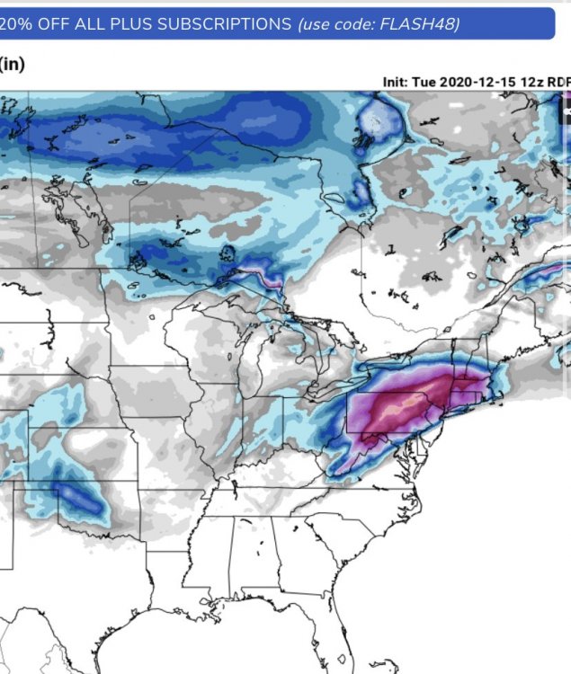
RDPS at 45h. It’s being nice
-
What have I done. What have I done. What have I done to deserve this.
-
 1
1
-
-
1 minute ago, mattm4242 said:
The NAM is likely out to lunch as far as it being that much of a hugger, but could it be the start of another bump north on the other models?
It can. And that is bad hehe
-
I’m biting my nails over the 12z GFS which rolls out next.
Odds are, it will look more favorable than the NAM, tho the latter can’t be ignored
-
I’ve mentioned my paranoia about major north and west trending on storms as have a few others.... but this surprises me because in my memory I feel like the dangerous northwest ticking toward rain territory usually happened about 48-72 hours prior to the event.... not under 48 hours. Like, “we should have known about this last night”
It looks “okay” for me here but if it did this now, what’s next for 18z etc etc!
-
1 hour ago, WxWatcher007 said:
I think that’s the main risk for us. It should still be great statewide, but we’re kind of playing with fire with some level of slotting.
When I saw lots of 06 z runs pull up the dividing line between magenta and purple on kuch snowfall to about a north haven- Ledyard- Hopkinton line, it was kinda creepy.
-
50 minutes ago, RUNNAWAYICEBERG said:
It no longer looks like the chase will need to be down to the sw coast ey?
The trend isn’t surprising to me! At Willi, I’m even a bit more worried about ptype than suppression. It’s not predicted by models yet, but that ocean.... I know I’m being paranoid
story of our life
-
 1
1
-
-
4 minutes ago, Snowcrazed71 said:
Are we at a better time frame now being within 48 hours of the storm and using the NAM model. I'm still worried about the gyro heading stupid South, and the GFS not really moving North but, now that first thing is on shore is much better sampling going on for tonight tomorrow. I'm just going to expect 6in and if I get more that'll be exciting. I'm thinking I'm in a very good spot being right in the center of Connecticut
Hahaha If We are talking in the context of locking in a run like that, 6 inches would mean something went horribly wrong!
-
2 minutes ago, JC-CT said:
I dont see how this misses
No we are in almost the best location, I think the worst case is a solid 5 inches no matter what goes wrong or different
-
 1
1
-
-
19 minutes ago, JoeSnowBOS said:
This one has bust written all over it. GFS is south and has been. Euro was a big hit but slowly starting a trend south toward GFS. Yet some models still have clown snow maps. Keeps the hope alive but in the end this will be one of those “man we followed this for days and all for not”
And the media has passed the point of no return in announcing what’s supposed to be ahead
-
1 minute ago, JC-CT said:
He's not wrong about a likely sharp cutoff. And he may not be wrong about where it sets up. What people think he's wrong about is his level of certainty about it.
The run smacks of seeing something gfs always did. And it’s so damn creepy
-
Just now, dryslot said:
If you can bring reasonable analysis i don't care who comes in and post, But they did sub forums years back for a reason....................
")
There’s obviously a huge reason yes.... which is why I think it’s weird that it turns out needing to mix like it does. As in, I don’t think there is much solution and it just rolls that way. I feel like maybe back then, and maybe it’s still this way, the plains states board was too huge of an area and Included places like New Mexico and was sparsely used?
-
1
-
-
2 minutes ago, dryslot said:
We are being invaded in our thread by new yorkers.
Well when I was living in Des Moines, I needed to interact with the Great Lakes board for relevant interaction. even tho I am closer to the plains and that board technically was where I belonged, it just didn’t work that way hmm
-
1 minute ago, JoeSnowBOS said:
NAM way south with precipitation. All guidance starting to come down to the GFS solution. All hail the GFS!! (If it is right in the end)
I prefer to think they meet half way
-
17 minutes ago, JC-CT said:
It's finally snowing here as the back edge approaches, just never really got enough precipitation.
It has done a bit of backbuild look to it or at least a quick fill-in.
But I think it’s probably too late too
-
1
-
-
Change to snow is occurring
-
1 minute ago, USCAPEWEATHERAF said:
This is the best map used for deciding where the model feels the dry slots will be located!
Kinda creepy
-
3 minutes ago, USCAPEWEATHERAF said:
The storms like DEC 2010 where the band brought a foot of snow to the eastern half of Cape Cod the Monday before the Boxing Day. There are plenty of examples of shortwaves being dampened too quickly, can I name every situation, no I can't. However, that does not mean I am spewing crap off the top of my head. Every situation is different, but today's storm could be a signal that the pattern is more favored to amplification than models would indicate. yesterday the storm for today was forecasted to bring a band quickly through the Cape and then offshore, however, judging by radar, that band is aimed right at the Cape and Islands and is not moving until the backside slides through, currently over western CT. Lean towards amplification.
A call for a quick inch or two of snow in northern CT was made as well... but it’s been a rainy mix with steady 35-36 degrees.
-
2 minutes ago, JC-CT said:
And I would hate to win the lottery because I want to stay true to my roots.
And when you do, you shall purchase the materials to build a small cabin high in a random mountain range of eastern Nevada, experience lots of good moderate snow events. You shall stock years worth of canned goods and do SETI.
Stay out of Florida and Hollywood
-
1
-
1
-
-
Just now, STILL N OF PIKE said:
the cut off is real. Maybe it will sink south 50 miles and be on the S Coast and we can see the S of Pike crew Melt down. I don't want to see this for the record lol.
Feelings aren’t facts.
Feelings aren’t facts.
-
2
-
-
5 minutes ago, WinterWolf said:
Most of CT has been very good in every run..except the GFS.
Ya that map is excellent for most of CT.
Yeah. The GFS looks suspicious as it has been so consistent Lately... and I’ve read what people are saying about it... but at +- 60 hours out with 2020 tech you would think Euro would have caught on more aggressively by now.
I feel like the worst case scenario would be a tick north with GFS.
I’m not the best person to talk to about it but I can’t think of any recent events that would show up like the euro just did and bust out with 3 inch pixie in an area indicating a 15-18 inch hit within this time frame
-
Well, I suppose I’m in the best spot possible then?
-
3 minutes ago, TheSnowman said:
Since 1992-1993. Since that season, even existed In a New Snow Era for New England. MBY Alone has averaged 62”, after All previous data To 1992 was only 48”.
Some years are just very snowy across the whole country.

Active mid December with multiple event potential
in New England
Posted
Ya GFS emphasizes what one poster said about western CT being better off, but eastern CT isn’t exactly screwed either.