
IowaStorm05
-
Posts
1,486 -
Joined
-
Last visited
Content Type
Profiles
Blogs
Forums
American Weather
Media Demo
Store
Gallery
Posts posted by IowaStorm05
-
-
-
14 minutes ago, RUNNAWAYICEBERG said:
Gfs with the colder se tick as well.
Looks quasi elevation dependent in CT
-
Just now, ORH_wxman said:
That was a pretty cold rgem run considering 18z was pretty torchy.
Something in me told me 18z was faulty despite my logical respect for it
-
Sorry, I had to do it. Canadian. Enjay this run
-
 1
1
-
-
Beautiful run. A thick 2 inch coating in Central Park?
-
This run looks good for most/all. I love it.
-
 1
1
-
-
It might be impossible to produce snowfall expectation maps yet until we are within 36 hours. Some big jumps tonight in models, no unilateral consensus. It could be 1 inch here, or it could be 10.
-
2 minutes ago, HIPPYVALLEY said:
He may just mean uniform, region wide snowfall.
Region-wide snowfall for Knee England.
-
1
-
1
-
-
I am hoping 18z is just a bad batch of runs but Those were some serious jumps north, and the more likely outcome is said to be a Northerly Solution.
-
How much more snow would Reno, NV get than the 20-40 inches per year the greater metro area normally receives... if you took a huge chain saw and shaved 1000 feet off the top of the Sierra crest for the length of the mountains?
I wish there was a big and active forum here for specific western regions, but I guess there aren't enough people living out there to have the congregation of the New England forum I am a part of out here.
-
1
-
-
4 minutes ago, HIPPYVALLEY said:
The topography of New England, offers quite a long list of potential snow holes.
Sure it does.
I also wrote to some of the Mets at NWS Reno and asked how much more snow Reno would get, if you took a huge chainsaw and shaved the top 1000 feet off the crest of the Sierra Nevada.
-
 1
1
-
-
This is amazing to see a
6 minutes ago, Whineminster said:All downsloped locales
As a younger hobbyist I would not have thought that the topography of anyplace in New England was enough to cause significant rain shadowing for snow events. I thought you needed HIGH mountains for that effect.
I think a good way for us to ensure that the valley gets its just desserts would be to gather all of you, go to that valley, and release 1.5 Million balloons into the air at once, shortly before the storm arrives, and use the event as a fundraiser for a significant upgrade for the GFS.
-
1 minute ago, Cold Miser said:
Excited on 2" of snow and sleet fest?
Actually I wouldn’t mind that much. It would be interesting. But in all the years of my living I’ve never seen a “sleet fest” before.
And I just changed my moms headlights from “Sylvania Basic 9005” to “Sylvania Silverstar 9005”.
-
1
-
-
2 minutes ago, Damage In Tolland said:
Once Nam sniffs.. lock it
Meh I’m not impressed yet. It’s longer range for the NAM and I’ve seen it be wrong for this.
Which is good for me I don’t want the NAM solution anyway.
-
6 minutes ago, CoastalWx said:
Just twist
I’m not the one whose so far away when I feel the snake bite into my veins
-
 1
1
-
-
You’re going to make me engage in behavior that gets me “warning points”
-
2
-
-
-
Now I'm gettin excited and its kind of too soon still.
-
1 minute ago, Ginx snewx said:
The only snow in Westerly in 2002 was Jan 21st 6 inches
I tried to find the info for that event just a minute ago and spent 10 minutes poking around for data and was unsuccessful because there was so many different things to ask for. Comprehensive indeed..
I only remembered getting 4 or 5 inches for that event. But 6 is close enough. 20 years is enough to bend memories.
-
13 minutes ago, George001 said:
Not as much as it seems. 80 inches is a lot, but there’s a good chance Boston gets to 50 on Friday, probably more. Then there is the next week storm, which I am extremely bullish on due to how amplified the ridge out west is. There is a good chance Boston is at 60 or so inches headed into March (this is conservative based on the upper air pattern for the end of Feb) Then 20 or more inches on March.
I would like your wisdom and POSITIVE THOUGHTS to tell us what you think additional accums for the Kev/JC/Iowa/Ginxy zone will get to over the next couple weeks. Maybe with a little science too!


-
10 minutes ago, MJO812 said:
Boston is at 43 inches for the winter. They will get to 60 inches.
Meanwhile Albany only has 17 inches
Has Eastern New York State had climo problems with snowfall in the last decade, a decade where SNE has seen more good storms (The 2010s)?
I know it's just my sensation, but I always feel like Albany is some netherworld no-man's land. It's not new england, but it is the same region. It's like an undiscovered bonus room. It's like where you would end up if you managed to jump over the flag at the end of a Super Mario Brother's level
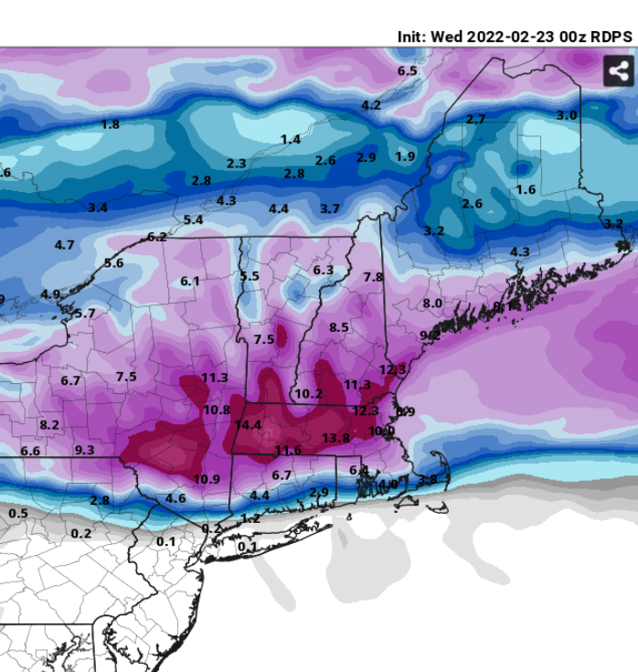
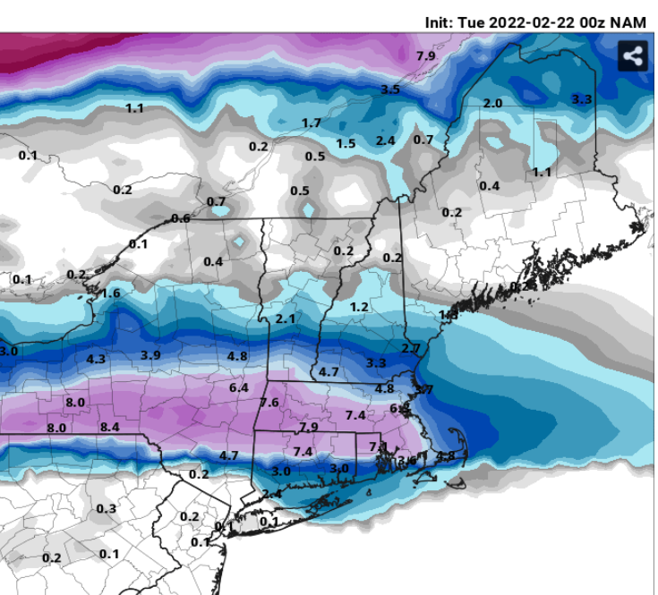
Someone will get mad that I posted this, but 00z NAM
-
As long as this doesnt take a big hike north, maybe I can count on a good thump. 3-5 inches with sleet mixed in... A white concrete slab.
-
2 minutes ago, Ginx snewx said:
18Z Euro is thumpity thump
Can you please share?
-
7 minutes ago, ORH_wxman said:
Except for the times it isn’t. Sometimes it’s closer to MA/CT border (like 12/16/07) or sometimes it’s more like HFD-PVD line where the sleet stalls (like 12/13/07 or 2/5/14) and others it’s the pike and others it’s MHT-PSM (12/3/07?)
This one looks like it might be near the pike but it could be more near you too. Or up by rt 2.
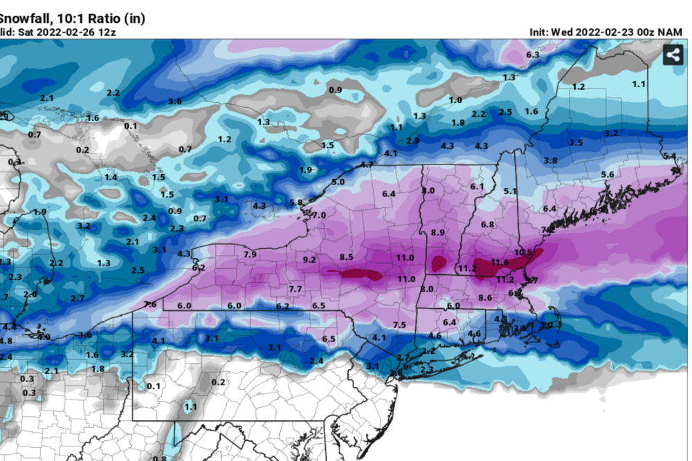
2/5/14 is a pretty good looking analog right now. 1/28/09 is a decent analog too but I don’t like how that one had the high sliding east. Both this event and the 2/5/14 event have the high in a very good spot not sliding east so it may be tougher to trend the sleet well north up into MHT or CON.
Where can I go to find snowfall maps for all these historical events? With major winter storms I can often google image and I get a map on google. But a storm like "2/5/2014" is not among em. Same for other systems as well that I have wanted to look up, for example, the only significant snowstorm for Westerly RI during the 2001-2002 winter in which I was in high school.
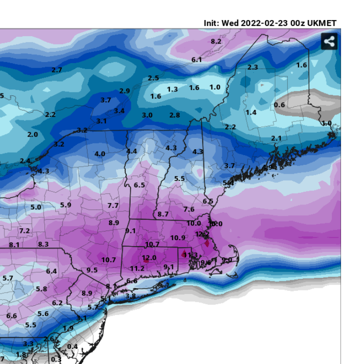

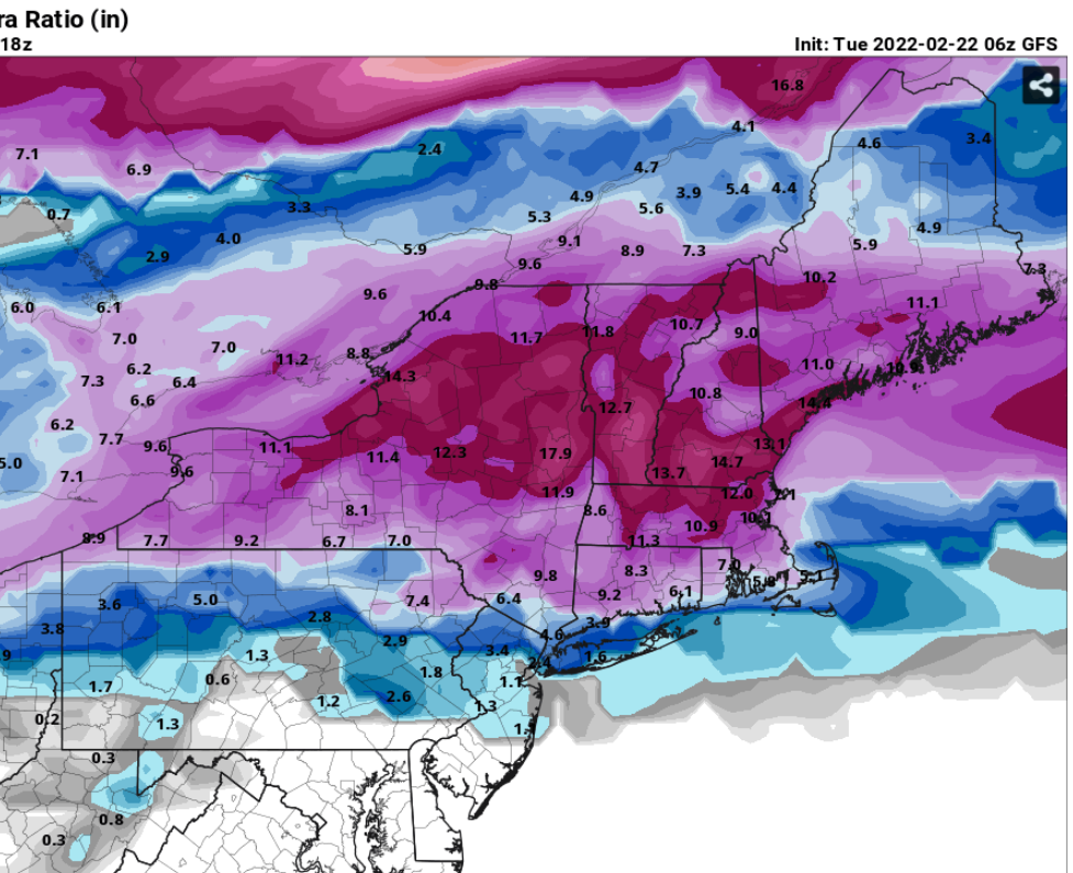
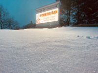
Winter storm for the 25th of February is imminent.
in New England
Posted
Thats reckless. The 06 GFS also looks similar to me.
On the other hand, 06 CMC or NAM look horrifying, but it is mid range for NAM