IowaStorm05
-
Posts
1,486 -
Joined
-
Last visited
Content Type
Profiles
Blogs
Forums
American Weather
Media Demo
Store
Gallery
Everything posted by IowaStorm05
-

Active mid December with multiple event potential
IowaStorm05 replied to Typhoon Tip's topic in New England
Yeah I’m noticing how cold it’s coming in for Philly -
Active mid December with multiple event potential
IowaStorm05 replied to Typhoon Tip's topic in New England
I’ve been armchair hobbying weather at various intervals and when I was a kid it was consistent and obsessive. But tonight is my schooling lesson and first exposure to the notion that amounts could really vary like that without, for example, rain shadowing or whatnot. “Subsidence” takes on a whole new meaning to me tonight. I didn’t know everyone got screwed when we got crushed in 2010. Just wow! -
Active mid December with multiple event potential
IowaStorm05 replied to Typhoon Tip's topic in New England
I looked back on the Dec 2010 storm after Ice1972 didn’t like it... and the snow map I found was... erratic. I was in Coventry, CT.... I swear we got feet. At LEAST 20 inches. But this map shows bulk of CT with random numbers many under 6 inches... with lots of “dots and bubbles” -
Active mid December with multiple event potential
IowaStorm05 replied to Typhoon Tip's topic in New England
This all looks great. But I’m not sure it will be a Christmas 2010 in CT just yet -
Active mid December with multiple event potential
IowaStorm05 replied to Typhoon Tip's topic in New England
Oh ya I remember living in Woonsocket in early 2004. It was a decent winter in SNE, but at least a few snows missed us to the south, hitting Warwick and Westerly -
Active mid December with multiple event potential
IowaStorm05 replied to Typhoon Tip's topic in New England
Oops but even better -
Active mid December with multiple event potential
IowaStorm05 replied to Typhoon Tip's topic in New England
I looked it up at least it did snow in all of CT and only extreme SE got screwed. It looks like it was 7-9 inches for JC-CT, me and Tolland. -
Active mid December with multiple event potential
IowaStorm05 replied to Typhoon Tip's topic in New England
What exactly does that translate to (for us newbies). A rain snow line from Norwich to Providence to Boston? When I look at past classics, or common events, that rain/snow line has wildly varying different degree of tilt slicing thought coastal plains, but it’s there nevertheless -
Active mid December with multiple event potential
IowaStorm05 replied to Typhoon Tip's topic in New England
So in summery aren’t buying the 12z Euro -
Active mid December with multiple event potential
IowaStorm05 replied to Typhoon Tip's topic in New England
What’s this deal with the snow line completely and perfectly contouring itself over the coast proper? -
Active mid December with multiple event potential
IowaStorm05 replied to Typhoon Tip's topic in New England
Yeah not game over but way too close for comfort. If we get a 25 mile tick SE on the most adversarial models and lock it in, we are good -
Active mid December with multiple event potential
IowaStorm05 replied to Typhoon Tip's topic in New England
Forgive my frivolous comment. But I sit here and I dream.... Canadian and Ukie stay steadfast, and suddenly NAM and GFS dive 45 miles southeast on their 18z runs. Hopes. Dreams. I finally take a shower. -
Active mid December with multiple event potential
IowaStorm05 replied to Typhoon Tip's topic in New England
Ya GFS emphasizes what one poster said about western CT being better off, but eastern CT isn’t exactly screwed either. -
Active mid December with multiple event potential
IowaStorm05 replied to Typhoon Tip's topic in New England
If ya wanna talk about embarrassment I’ll tell ya all about it -
Active mid December with multiple event potential
IowaStorm05 replied to Typhoon Tip's topic in New England
RDPS at 45h. It’s being nice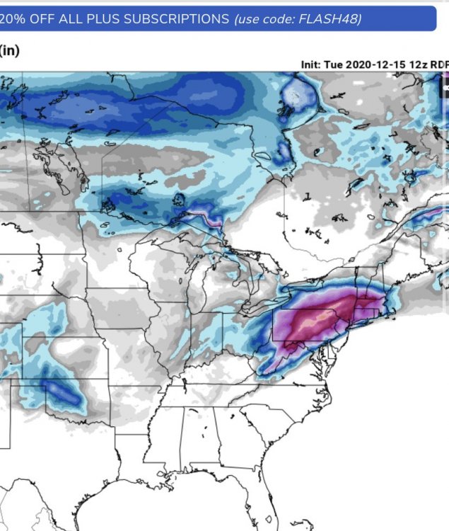
-
Active mid December with multiple event potential
IowaStorm05 replied to Typhoon Tip's topic in New England
What have I done. What have I done. What have I done to deserve this. -
Active mid December with multiple event potential
IowaStorm05 replied to Typhoon Tip's topic in New England
It can. And that is bad hehe -
Active mid December with multiple event potential
IowaStorm05 replied to Typhoon Tip's topic in New England
I’m biting my nails over the 12z GFS which rolls out next. Odds are, it will look more favorable than the NAM, tho the latter can’t be ignored -
Active mid December with multiple event potential
IowaStorm05 replied to Typhoon Tip's topic in New England
I’ve mentioned my paranoia about major north and west trending on storms as have a few others.... but this surprises me because in my memory I feel like the dangerous northwest ticking toward rain territory usually happened about 48-72 hours prior to the event.... not under 48 hours. Like, “we should have known about this last night” It looks “okay” for me here but if it did this now, what’s next for 18z etc etc! -
Active mid December with multiple event potential
IowaStorm05 replied to Typhoon Tip's topic in New England
When I saw lots of 06 z runs pull up the dividing line between magenta and purple on kuch snowfall to about a north haven- Ledyard- Hopkinton line, it was kinda creepy. -
Active mid December with multiple event potential
IowaStorm05 replied to Typhoon Tip's topic in New England
The trend isn’t surprising to me! At Willi, I’m even a bit more worried about ptype than suppression. It’s not predicted by models yet, but that ocean.... I know I’m being paranoid story of our life -
Active mid December with multiple event potential
IowaStorm05 replied to Typhoon Tip's topic in New England
Hahaha If We are talking in the context of locking in a run like that, 6 inches would mean something went horribly wrong! -
Active mid December with multiple event potential
IowaStorm05 replied to Typhoon Tip's topic in New England
No we are in almost the best location, I think the worst case is a solid 5 inches no matter what goes wrong or different -
Active mid December with multiple event potential
IowaStorm05 replied to Typhoon Tip's topic in New England
And the media has passed the point of no return in announcing what’s supposed to be ahead -
Active mid December with multiple event potential
IowaStorm05 replied to Typhoon Tip's topic in New England
The run smacks of seeing something gfs always did. And it’s so damn creepy