WinterWxLuvr
-
Posts
29,279 -
Joined
-
Last visited
Content Type
Profiles
Blogs
Forums
American Weather
Media Demo
Store
Gallery
Everything posted by WinterWxLuvr
-

January 16-17, 2022 MLK storm obs/now cast
WinterWxLuvr replied to George BM's topic in Mid Atlantic
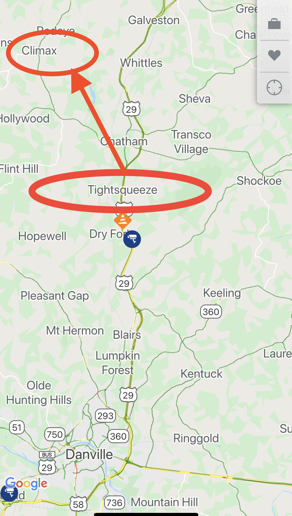
Conditions in southern Va deteriorating rapidly -
January 16-17, 2022 MLK storm obs/now cast
WinterWxLuvr replied to George BM's topic in Mid Atlantic
OMG Bob I didn’t even see that lol -
January 16-17, 2022 MLK storm obs/now cast
WinterWxLuvr replied to George BM's topic in Mid Atlantic
Only in Virginia lol
-
January 16-17, 2022 MLK storm obs/now cast
WinterWxLuvr replied to George BM's topic in Mid Atlantic
Snow along the Va border near Martinsville and Danville starting to come down at a good clip -
Looks great!
-
January 16-17, 2022 MLK storm obs/now cast
WinterWxLuvr replied to George BM's topic in Mid Atlantic
Snow is reaching the ground via traffic cams almost to Roanoke now. Appears to be very little virga at the start. -
January 16-17, 2022 MLK storm obs/now cast
WinterWxLuvr replied to George BM's topic in Mid Atlantic
All models had this low at some point very close to the coast. Then it basically shoots straight north. -
January 16-17, 2022 MLK storm obs/now cast
WinterWxLuvr replied to George BM's topic in Mid Atlantic
If you see me making a post regarding the NAM, it will be because I’m bashing it. -
January 16-17, 2022 MLK storm obs/now cast
WinterWxLuvr replied to George BM's topic in Mid Atlantic
It’s obvious that the NWS is going with the NAM
-
Ala Feb 2, 2010?
-
If somebody does, I hope it ends up in Detroit with thunderstorms here
-
Look familiar?
-
Not for me this time lol. I’ll check this daily until about Thursday
-
January 16-17, 2022 MLK storm obs/now cast
WinterWxLuvr replied to George BM's topic in Mid Atlantic
NAM radar prediction for 12z off by about 100 miles. I expect it to be able to nail the rest of its forecast though -
How about 18z?
-
January 16-17, 2022 MLK storm obs/now cast
WinterWxLuvr replied to George BM's topic in Mid Atlantic
. It’s a glitch with the algorithm that’s making the snow map. Notice it’s not on the WB maps -
Gfs did the exact same thing with this storm. Had it, lost it, brought it back
-
January 16-17, 2022 MLK storm obs/now cast
WinterWxLuvr replied to George BM's topic in Mid Atlantic
Yeah this is suspect
-
January 16-17, 2022 MLK storm obs/now cast
WinterWxLuvr replied to George BM's topic in Mid Atlantic
Right under the low? IDK -
January 16-17, 2022 MLK storm obs/now cast
WinterWxLuvr replied to George BM's topic in Mid Atlantic
Not a way to justify. Learned my lesson on that one a few years ago with an Apps runner which I definitively said wouldn’t happen…and did. Just a very unusual storm IMO -
January 16-17, 2022 MLK storm obs/now cast
WinterWxLuvr replied to George BM's topic in Mid Atlantic
This is an extremely rare event. I’ve never seen it unfold like this. -
January 16-17, 2022 MLK storm obs/now cast
WinterWxLuvr replied to George BM's topic in Mid Atlantic
That’s higher here also. In other news, ICON moves snow totals east. -
January 16-17, 2022 MLK storm obs/now cast
WinterWxLuvr replied to George BM's topic in Mid Atlantic
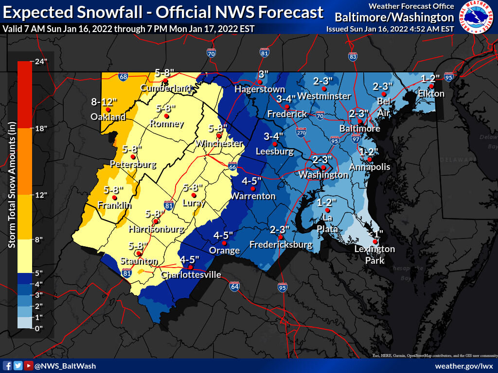
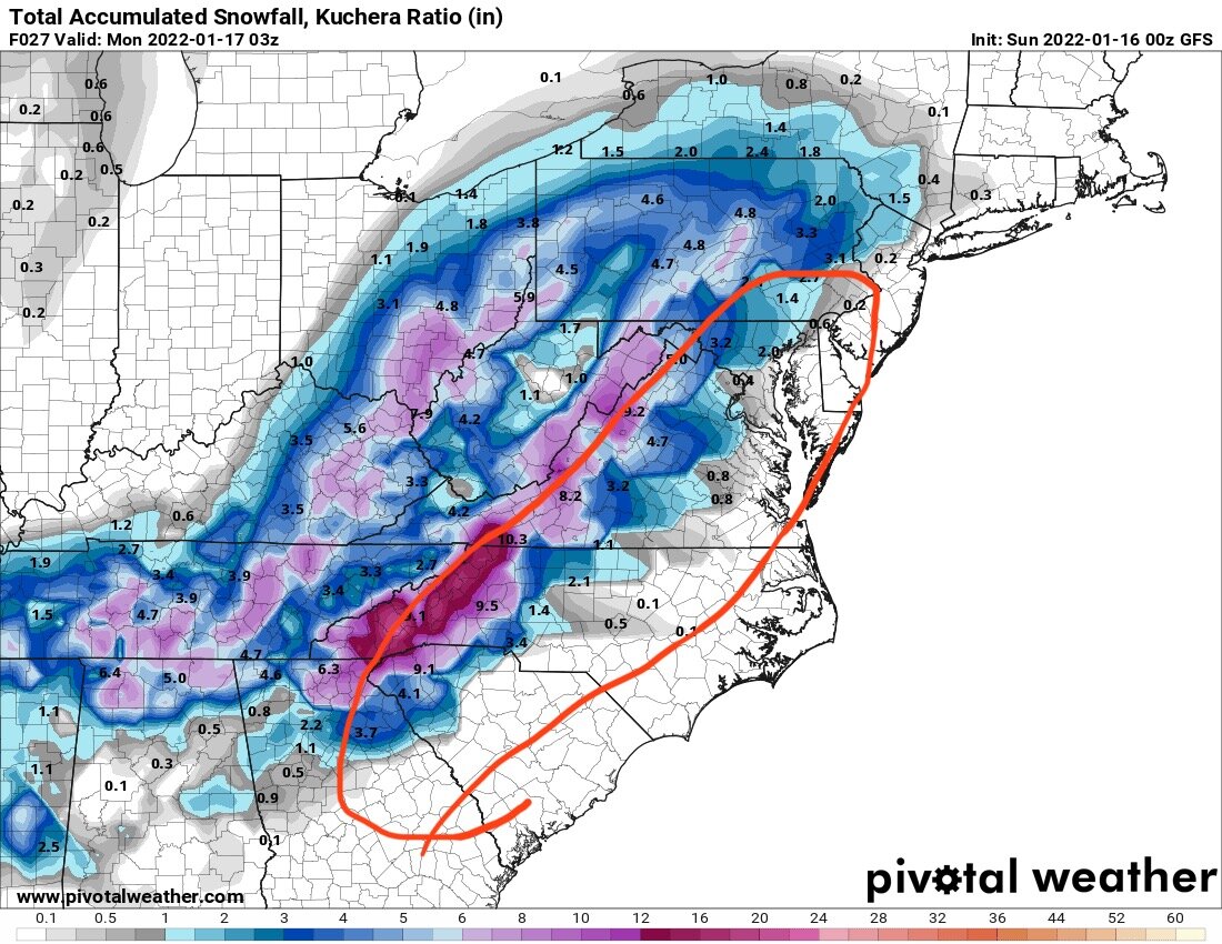
The NAM show 0.00” of precip in places in WV by 9z tomorrow night that are forecast to have 6+” of snow by then -
January 16-17, 2022 MLK storm obs/now cast
WinterWxLuvr replied to George BM's topic in Mid Atlantic
Took me a minute to get this one -
January 16-17, 2022 MLK storm obs/now cast
WinterWxLuvr replied to George BM's topic in Mid Atlantic
Keep up the good work