jculligan
-
Posts
451 -
Joined
-
Last visited
Content Type
Profiles
Blogs
Forums
American Weather
Media Demo
Store
Gallery
Everything posted by jculligan
-
I do feel like this is my obligation lol. One of the trade offs of being able to set a skin track from your front door
-
I feel the same way. Granite Backcountry Alliance has done a ton of work over the last few years to thin out specific glade zones, and I've been looking forward to exploring them this season. One of the zones is up on Crescent Ridge, which is very close to where Phin is located. Given the fact that Phin pulled nearly 20" out of this event, I think that might be my target zone next weekend. There is something to be said for the more open hardwoods in Vermont. NH has more extreme terrain with the various gullies and couloirs that are scattered throughout our alpine terrain in the Presidentials; so we have the steeps, but I think Vermont has far better tree skiing.
-
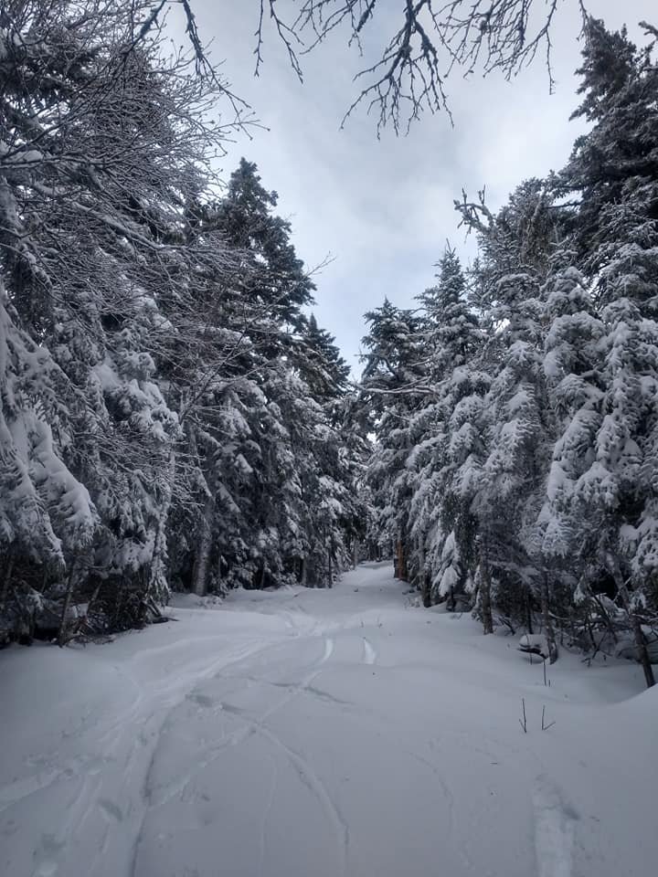
Finally got to do a backyard ski tour both yesterday and today. I think "character building" is the best way to describe it here on the eastern slope. We managed 8" of snow here at 1500' on Saturday and probably more like 10-12" at the top of North Doublehead (3,000') behind my house...but the freezing line soared all the way to the summits at the end of the day, with the event ending as rain. We did not get any of the upslope on the backside of the storm, so when temps tickled back below freezing we ended up with a horrendous crust that wasn't enough to support your weight (the dreaded "breakable crust" to put it into ski terms). The only way to safely descend without tweaking your knee or tearing your ACL was to alternate between jump turns, downhill kick turns, side stepping or the good old fashioned pizza. Really quite horrendous for backcountry skiing. The crust was still there today, but it has firmed up and is a little more supportive...so I feel like today's tour allowed me to ski a little bit more normally. You guys on the west side are so damn lucky to have the benefit of upslope. The woods out this way are not in good shape (even if they look pretty). But hey, it's going to be one hell of a base that we can now (hopefully) build on.
-
I don't think our snow depth really took a hit because it was relatively brief, but it definitely dripped off the trees. But I feel good heading into the upcoming colder spell with a foot of snow on the ground. It's real winter now.
-
Things did get a little dicey here at the tail end of the event. I measured 8" at 3pm but it turned to sleet and even rain very shortly afterward, and we did creep up to 35F with mist/drizzle for a few hours. I skinned up to the summit of Wildcat after sunset this evening, and it was sheet drizzle straight to the summit at 4k. Hopefully we can get some scraps from the wraparound overnight to make it pretty again.
-
Seriously thinking about it tomorrow. Doublehead is literally right behind my house, and we have a 12" base in my backyard now (presumably more up top which is at 3k). I've got a pair of rock skis so I may take them out tomorrow and just see what I find. Its mid January and I'm anxious lol.
-
8" down as the precipitation starts to let up. Some pingers mixed in to add a little extra beefiness to the pack. Solid 12" on the ground now. Still holding at 32F. I know the valleys got skunked, but things finally seem right here at 1500 feet!
-
Getting hard to tell because of drifting, but I just got multiple 7" measurements in the yard. I think we picked up at least 2.5" between noon and 1:00. Still 32F with heavy snow and it appears the back edge may be filling in a bit.
-
Another 1.3" last hour for a total of 4.3" as of noon. Still holding at 32/31. Hoping we can keep this going for a couple more hours. Nearly every event has landed at almost exactly 6" here so far, and it appears this event won't be much different. I'll take it!
-

January 16 2021 - Inland runner Rain/Snow/Wind
jculligan replied to Baroclinic Zone's topic in New England
2.2" last hour for a total of 3.0" on the nose here at 1500' in Jackson. At 9am it was a mix of rain and snow and 36F in Jackson village, about 700' below me. But we are getting crushed here. -
2.2" last hour. 3.0" total. Dumping.
-
Insanely low visibility at the moment - probably the lowest I've seen in years. I took my first measurement at 9:50 and I'll be taking them on the hour. Still hovering at 32/31. Fingers crossed that diabatic cooling and heavy precip rates can fight off the low level warming that is trying to push in at the same time.
-
I am literally on the line right now. Just drove up from the valley where it was 36 with alternating rain/snow and no accumulation. Here at 1500' it is 32/31 and I have about 1" down so far. Started in earnest around 9am.
-
32/30 with 0.3" overnight. I'm going to be on the razor's edge with this one...
-
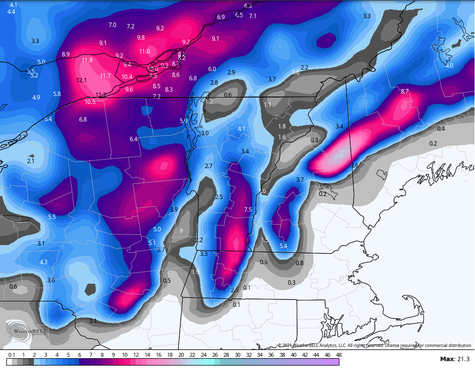
RGEM painting my area in the jackpot. The upslope/downslope effects during this storm could be quite extreme. Super tough call here at 1500' but I know I'll be cranking out some pretty ridiculous precip rates from about 9am-3pm and a good amount of that should be snow. This is a classic setup for my area to be near the QPF maximum.

-
I think you're a strong candidate to jackpot from this one. With the slight tick to a colder solution, I'm feeling more confident that I will do very well during the initial thump (probably a hair better than you) but you'll make up for it with the upslope that follows while I enjoy stray flakes under a partly sunny sky.
-
I'm 50-60' lower than both of you - pretty much exactly 1500' in my location. I think we're going to pound precip rates when the LLJ slams into the eastern slope, but it's going to be a nail-biter with the rain/snow line here. Another 500' would make me feel more comfortable. I could literally see 3" of slush followed by pouring rain, or a double digit blue bomb. Definitely nervous but the trends have been positive today.
-
While I'm not super optimistic about the outcome of this event imby, the recreationist in me is fairly excited about the potential for the high country on the east side of Mount Washington. It looks like thermal profiles support mostly snow for the duration of the event at elevations above 3000' and potentially down to 2000'...and with a pretty robust easterly LLJ, I think there will be a period of pretty impressive snowfall rates for places from Pinkham Notch up to Hermit Lakes. Ratios won't be very impressive, but I can definitely envision up to 15" of dense base-building snow to finally open up some of the backcountry terrain on the east side of MWN (Gulf of Slides, Sherburne Ski Trails). I might finally be able to stop lapping groomers when this is over. Good upslope potential for the Vermonters and Alex/Phin on the backside of this thing Sunday into Sunday night as well.
-
I'm not sure I entirely buy into the idea of a changeover to rain up to 3,000' quite yet. If the Canadian/NAM solution were to verify, then yes...I agree this is a possibility. But the Euro/GFS are decidedly colder, and the Euro is actually a good snow event for the majority of the White Mountains. At 60+ hours I will hedge toward the Euro/GFS over the Canadian/NAM just about every time. I do think that areas south of the notches and below 1500' in elevation are in trouble. This will likely be another miss for the snow-starved Mount Washington Valley, which has really only seen two significant snowfalls so far (12/17 and 1/2). I think North Conway proper is only around 12" for the season to date at this point. But I have a feeling the Canadian/NAM will hedge closer to the Euro/GFS solution as we get closer, and I'd be feeling reasonably optimistic if I were Alex and Phin right now. I'm not as confident about my immediate location.
-
0.5" of fluff from many hours of steady very light snow late yesterday. Could be a long wait before the next measurable now. Models have been teasing on and off for the Tuesday/Wednesday period next week, so hopefully that starts to gain some traction in the coming days. Still a wintry feel out there regardless.
-
0.3" last night brings us up to an even 22.0" on the season so far. The current snow depth is 4-5 inches. I don't know of any reliable climo data for Jackson in particular, but the COOP in North Conway averages 20.2" through January 1st. I think I average about 1.5 times the amount of snow that falls in North Conway (120" seasonal total versus 80" in the valley) so I would presume we should be closer to 30" on the season at this point in my location. All things considered...we aren't that far off. I think where we are really struggling is in the snowpack department. I'm pretty certain there should be more than 4-5" OTG at 1500' in the eastern Whites on January 4th, but the December thaws really prevented us from making much progress. The maximum depth I've observed all season was 8" following the 12/17 event.
-
Ended up with 5.7" out of this event. It looks like we have some opportunities to pick up an inch or two here and there over the next few days (tomorrow night then potentially again on Tuesday) which should keep things looking fresh at least. No deep arctic air in sight, but no big rain storms/thaws either. I can do without either, so I think in general we're looking far better than we have for the last few weeks.
-
Seems to be wrapping up here now. Just measured 5.7" with the last flakes coming down.
-
Measured 4" on the nose here in Jackson as of 8am. Currently 27F with light snow continuing. No indication of any mixing here.
-
4.0" here in Jackson as of 8am. Light snow and 26F right now. Beautiful.