jculligan
-
Posts
451 -
Joined
-
Last visited
Content Type
Profiles
Blogs
Forums
American Weather
Media Demo
Store
Gallery
Everything posted by jculligan
-
Too cloudy here as well, but according to spaceweather.com this is shaping up to be a "bust" either way: THE CME HAS ARRIVED, BUT NO STORM YET: A CME hit Earth's magnetic field on Dec. 10th (1:30 UT), suddenly raising the solar wind velocity to nearly 600 km/s. So far, the impact has not triggered a geomagnetic storm. There is still a chance of storms in the hours ahead as Earth moves through the CME's turbulent wake, but this is not shaping up to be a major space weather event.
-
It's amazing how it adds up. What would you say your depth is right now?
-
Are you keeping tabs on your seasonal total? I'm really curious how these little 1-3" events that seem to happen once every few days are stacking up on the other side of the Notch!
-
Not much to contribute over the last day as Jackson was pretty much shut out from this recent event. I did wake up to a very slight dusting this morning, but not enough to measure. This was primarily an upslope event, so I hadn't been anticipating much/anything in my area either way. Even though I miss out on the upslope, I'm seeing how great the snowpack retention is going to be in my area. We haven't sniffed freezing since last Saturday, so we basically still have the full 6" snowcover that we collected during last weekend's event. Ventured up to the summit of North Doublehead once again yesterday (2.2 miles from my front door and 1500' higher) and there is still over a foot OTG. The trees between my house and approximately 2000' are still caked with snow since it was such a wet snowfall and there hasn't been enough wind to knock the snow off the trees - very picturesque! This weekend's event looks relatively insignificant from my perspective. I think the higher elevations that really got socked last weekend will go above freezing tomorrow and pretty much stay there through Sunday...but as long as we can keep things generally below 40F, the melt should be relatively insignificant. Models have really backed off on the overall QPF this weekend as well. Next potential "big deal" synoptic threat appears to be late Wednesday/Thursday of next week, which is now showing up on all the globals.
-
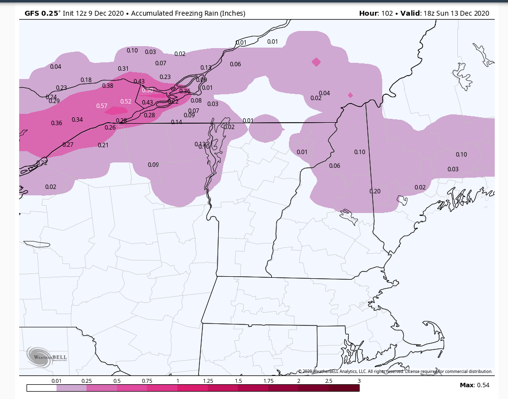
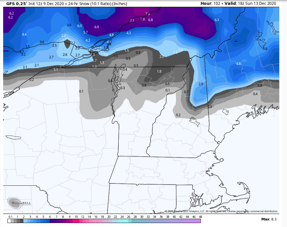
12z gfs definitely ticked colder for the weekend event. Appears to form a triple point low over Cape Cod Sunday morning which maintains a light east to northeast surface flow for many of us through a good portion of the day. Mid-level temps are a bit warm for snow in most areas (with the exception of Coos County into Maine at the onset Saturday evening)...but I would imagine this is a problematic setup in terms of freezing rain for CAD-prone areas Saturday night into Sunday morning.

-
Yes...in fact I personally witnessed this at Cannon Mountain last December. It was snowing enough to accumulate at the base of the mountain...then we ascended through the cloud layer and eventually broke above the clouds with the most amazing undercast I've ever witnessed at the summit.
-
Just a few days back, the Euro had my area torching into the mid 50s this weekend with 1" QPF all rain. Now we're looking at a 6" snow event (as modeled) and the "torch" is limited to a few hours Sunday night. The gfs/Canadian aren't as friendly, but even with its perceived struggles recently...I'm always inclined to lean toward the Euro over the other globals this far out. It'll be interesting to see how this trends over the next few days.
-
Many may already be aware of this, but there are three snow plots in the northern Presidentials....two on Mount Washington (Hermit Lake and Harvard Cabin) and one on Mount Adams (Gray Knob). All three are very close to 4000' in elevation: https://mountwashingtonavalanchecenter.org/snow-plot-data/ I've noticed some rather significant differences in snow depth between the Hermit Lake and Harvard Cabin sites, which is interesting because they are not that far apart from one another. Snow depths tend to be deeper at Hermit Lake. I've been to Hermit Lake plenty of times, but I've never made the trek over to the Harvard Cabin - I'm assuming the lower snow depths are either the result of wind scouring or perhaps a more dense forest canopy (Hermit Lake is rather open). I'll have to check it out this winter.
-
Hermit Lake started archiving daily snowfall amounts back in early 2018, but due to the Covid shut-down last year they've only had one full winter of publicly-available observations so far. They measured 190" in the winter of 2018-2019 (compared to 261" on the summit) and they were up to 175" on 4/13 last year before reporting stopped (compared to 253" on the summit). It's unfortunate that reporting stopped in mid April this year, because unusually heavy snowfall continued in the alpine for about another month after that. But regardless, based on the last two winters it seems that Hermit Lake averages about 70-75% of the summit's seasonal snowfall...which would correlate to an average of approximately 215" or 220". Again, this is based on a very limited data set...but it's all we really have to work with at the moment. I've been skiing the east side of Mount Washington on a very regular basis since 2013 and it's not at all uncommon for the peak seasonal depth to eclipse 90" in that location. It's a very impressive spot. I can't speak to the other locations you've noted, though I would imagine Hermit Lake has a higher average due to its elevation (nearly 3900' compared to 2800' at Lake Colden and 2900' at Chimney Pond). Maybe others in this thread can speak more to that!
-
When I looked at the lat/lon coordinates for the 15" measurement in Gorham 44.2613, -71.2833 it actually brought me close to the Hermit Lake SNOTEL on the east side of Mount Washington. I'm not sure if that technically lies within the established boundaries of the town of Gorham, but if so it's pretty misleading for the number to be reported this way!
-
Tagged North Doublehead again this afternoon, just to check out how much snow fell at 3k around here. Not surprisingly, it was absolutely crushed. There was a lot of drifting right on the summit which made it hard to estimate exactly how much fell up there...but I was breaking trail up to my knees on the way up. I passed an ambitious split boarder who can now claim the first descent of Doublehead this season - I'm happy to let the base consolidate before I attempt to ski the woods around here! I think another 200-300' of elevation would have made all the difference at my place. Above 2000' there was definitely a foot of snow imby.
-
I've been wondering how things transpired on the other side of Crawford Notch! It looked like the heavier echoes were having a hard time getting into your area for the synoptic portion of the event. I'm assuming the bulk of that accumulation was in the post-storm upslope stage, as we suspected would likely be the case.
-
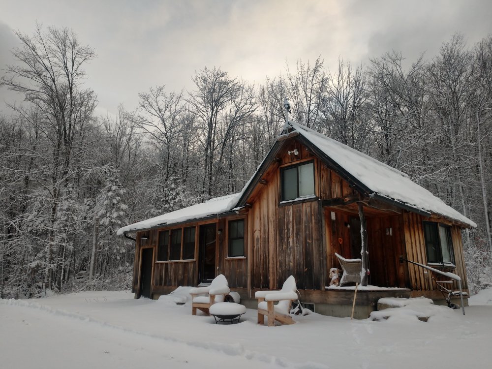
Interesting that it's been so windy out your way! Our wind was cranking last night, but it dropped off pretty dramatically around daybreak and it's been a relatively calm morning over here. I suspect we may be getting some form of blocking from the Presidentials - definitely still getting to know the local climate of this area. Still holding at 25F with overcast skies and a few flurries flying around. A proper winter day with the snow-caked trees adding to the ambiance.
-
There's the possibility of a weak clipper-type system moving through Wednesday night...but we're talking really insignificant stuff (coating to 1" deal) for most of us. I'm sure the usual suspects in VT will come in with somewhat higher totals. After that, things look dicey again heading into next weekend with all three globals showing a cutter. The Canadian seems most favorable for some frozen/freezing stuff on the front end as it implies somewhat deeper CAD than the other models - we shall see. Proper cold air returns in the wake of whatever happens next weekend.
-
I honestly have never paid attention to how snowy that part of NH is before! Thanks for shining a light on this ha. GBA (Granite Backcountry Alliance) has cut some ski glades off Crescent Ridge, and I think I'm now realizing that could be a really sweet place to check out this winter...
-
Definitely a water-logged snow! Unfortunately I don't have a heated rain gauge, so I won't know the liquid equivalent until temps rise above freezing again. I'm quite surprised we kept our power here, the way the branches were swinging around last night. I haven't ventured more than 30 yards from the cabin yet this morning, but in my super short survey I already found one large limb down across the driveway. I'm planning an afternoon hike up Kearsarge North with a buddy...it'll be interesting to see how much trail maintenance we have to do on the way up.
-
6" total here. Had the expectations not been higher, this would have been a decent first event. My friend in North Conway proper is reporting less than 1" down in the valley. Glad to have the extra 1000' here
-
4" now. 31/30.
-
Cracking sounds have started in the woods outside. It's amazing it only took 2.5" for that to happen. This is some of the most water-logged snow I've seen in a long time, and it is absolutely caked on everything.
-
2.5" as of 7pm. Finally dropped to 32F. Branches are absolutely caked and really starting to swing around in the increasing gusts. This could be trouble ha.
-
Wind is really starting to pick up here. Snowing more heavily than it has during the entire event so far. Still 33/31 but we must have a couple inches at least now. I'll measure again at 7:00.
-
1.2" as of 5pm. Officially the first 1"+ snowfall of the season here.
-
It's amazing the difference one degree can make. But I could be in the valley, where there is nothing...so I'll take what I have and be grateful ha.
-
Just got back from hiking North Doublehead. There was about 3.5" to 4" at 3000' with a temp of 30F. Accumulating way more efficiently up there, as one might expect. Still 33/31 here at 1500' with a total of 0.9" so far. Hopefully nightfall combined with the heavier bands pivoting in from the east will help us gain some traction.
-
33/31 and whitening up here, even beginning on paved surfaces. I'm hiking up the 3k peak in my backyard shortly, so it'll be interesting to see how much more is up there.