
Brian D
-
Posts
1,748 -
Joined
-
Last visited
Content Type
Profiles
Blogs
Forums
American Weather
Media Demo
Store
Gallery
Posts posted by Brian D
-
-
On 3/7/2024 at 2:20 PM, Brian D said:
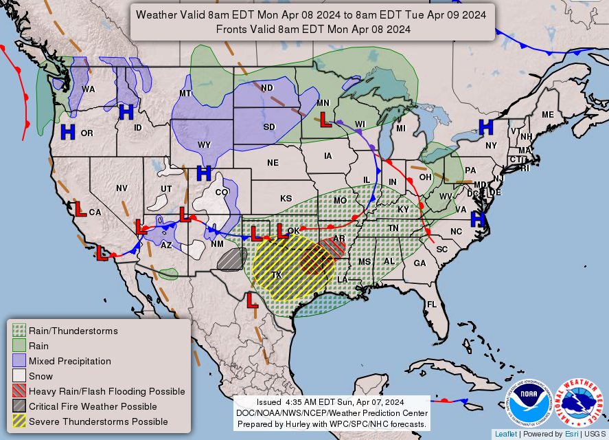
Since Easter ends March, and April 1st is indicated with my forecast for then, there isn't much for holiday or observance in April. There is, however an observance for National Library Worker's on April 9th. Looks like a system will be moving in bringing some warmer weather, and a threat for showers/stms.
 On 3/7/2024 at 3:16 PM, Brian D said:
Forgot about the solar eclipse. Hope this is wrong, but a quick moving front on the 7th-8th moving through our region. If this pans, hopefully it'll be through before the start of the event during the afternoon.
Basically running 24-36 hrs behind in my forecasts for this stretch. Mentioned a front 7th-8th which ended up being a weak trough, with a new system coming in on the 9th. Good luck in finding a good spot for eclipse viewing, as those limited areas will probably be quite packed due to cloud issues.
-
It'll being a rainy day for me, so when the eclipse hits it's peak for my area, a little added darkening to the gloomy day is all I get. Might be enough to get the street lights to come on.
Monday
Rain. High near 43. Breezy, with a northeast wind 15 to 20 mph, with gusts as high as 30 mph. Chance of precipitation is 80%. New precipitation amounts between a quarter and half of an inch possible.
-
Back in Feb 1979, when I was in school, we had a total eclipse nearby here. I remember the teacher had us poke a hole in a piece of construction paper, and aim it at the Sun during the eclipse. And had us lay a piece of paper flat behind it. You could watch the shadow of the moon on that flat paper slowly cover part of the Sun. No eclipse glasses back then, at least not for us. Got about as dark as when a strong storm complex moves in, and the street lights come on.
Here's the path of that eclipse from NASA files.
https://eclipse.gsfc.nasa.gov/SEhistory/SEplot/SE1979Feb26T.pdf
Jan of 1925 was the last time a total eclipse went over the Great Lakes. Started right over N MN.
https://eclipse.gsfc.nasa.gov/SEhistory/SEplot/SE1925Jan24T.pdf
-
 2
2
-
-
On 4/1/2024 at 7:32 PM, weatherbo said:
Every time there's a big late season snow, the "Mother's Day" storm of 1990 always comes up. I believe Negaunee received 24 inches and apparently was all melted by late afternoon the following day.
Didn't you have a big one last year on Mayday? Record snow for May I thought.
-
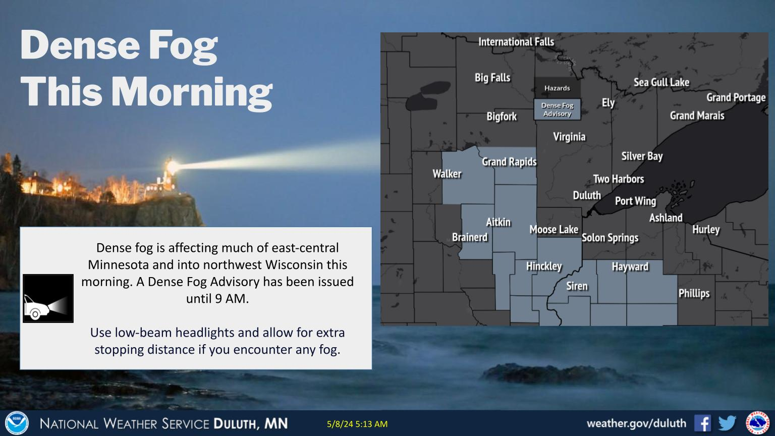
@weatherbo under the gun for a couple days. Light snow falling here atm.
-
1
-
-
For Memorial Day, looks like some wet weather will be moving through that weekend. Clearing out in the N sub on Monday.
-
For Mother's day, I'm expecting a storm system to affect our region. Here in MN, it's also MN Fishing Opener weekend.
-
23 hours ago, Chinook said:
this is last night's radar with my picture of a bird head
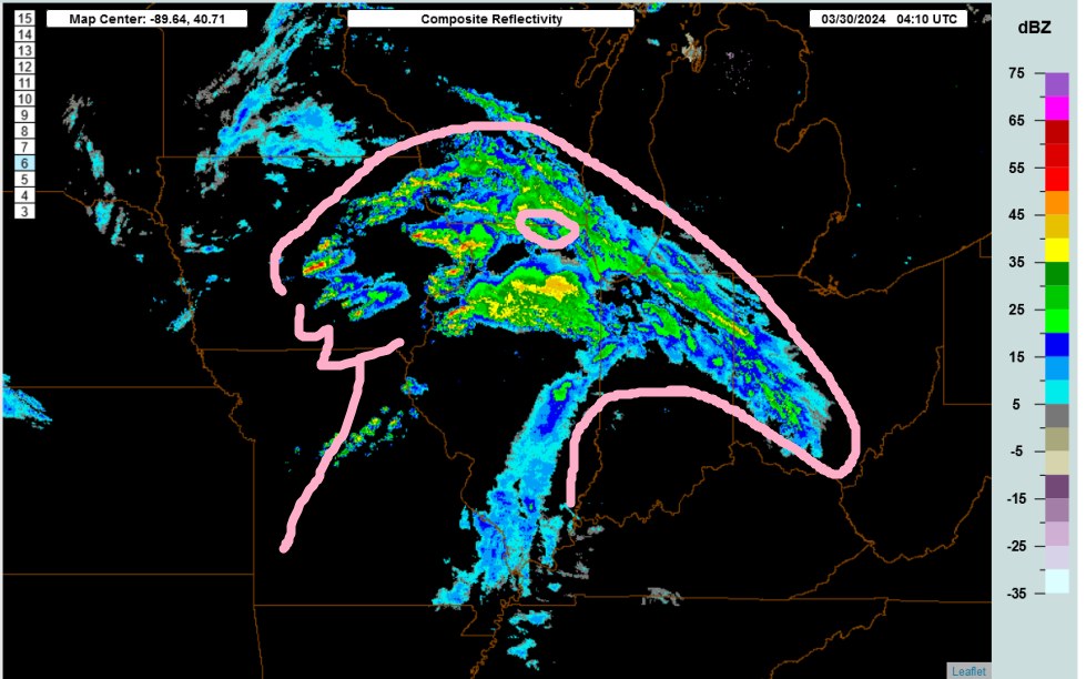
And the "Wolf's Head" of western Lake Superior over the top keeping hungry eyes on that bird.
")
-
On 2/7/2024 at 2:14 PM, Brian D said:
For Easter this year, I'm expecting a system to be moving through our region on that holiday weekend. A mild start turning wet & stormy, even into April Fools day.
Close call here. Had system a little more N, but it is moving through S sub the next couple days. There is a weak trough over the N areas. Happy Easter to all who celebrate.

-
2
-
-
Added mine in the Holiday Forecast thread a few weeks ago. Front moving into the region. Will it move through in time, or hang out long enough to create possible cloudy conditions?
-
6 hours ago, Brian D said:
I reported in during the event, and ended with 14" here in TH. Co-op observer had 13.5". Higher totals just outside town in the hills. There was a 21.2" report N of town yesterday, If they give an update, should be around 24-25". Very much needed this.
Just looking at SWE of this system, Monday's snow was really wet. There was a little rn mixed in between 2-4 am (couple hundreths).
TH co-op data:
2024-03-25 0.69 7.5 7 31 26 2024-03-26 0.55 2.0 8 33 27 2024-03-27 0.37 4.0 10 27 16 -
5 hours ago, Lightning said:
Nice event!! Should help at least a little bit with the current Drought situation.
The storyboard switched to a new one. LOL Best save them, and open in Paint, and resave as GIF. I do that with all large pic files to upload them here.
-
1 hour ago, Lightning said:
Nice event!! Should help at least a little bit with the current Drought situation.
I reported in during the event, and ended with 14" here in TH. Co-op observer had 13.5". Higher totals just outside town in the hills. There was a 21.2" report N of town yesterday, If they give an update, should be around 24-25". Very much needed this.
-
3
-
-
2 hours ago, Brian D said:
Snowing really good now. Radar showing increasing dbz along the North Shore.
Snow is slowly winding down now. Radar showing the E fetch turning from the N. Looks like 4-5" on the deck, but it has drifted some.
-
Snowing really good now. Radar showing increasing dbz along the North Shore.
-
4
-
-
16 minutes ago, TheClimateChanger said:
Here's Lansing, Michigan snowfall records [earlier years at East Lansing, Michigan], excluding a few years with excessive missing data:
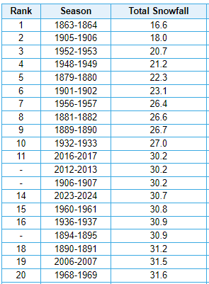
Maybe a bit questionable that the very first year with data ranks as lowest. Looking at the monthly data, that looks mostly a function of the fact that precipitation was 25-50 percent of modern norms for the bulk of the cold season.
The daily data shown at MRCC from Oct 1863-April 1864 is robust. Nothing missing. 16.6" is the final value for the season.
-
2 hours ago, OrdIowPitMsp said:
Absolutely puking snow. Roads are completely covered. Building up that late March snowpack. This storm has been awesome. Finally kicked the doldrums of nothingness we’ve been in for months.
10" yesterday imby, and we got a little rn last night before the band turned to snow. A couple inches of powder, and snowin good atm.
Told my grandson a couple months ago, watch, it'll snow a lot in the Spring if we don't get much over Winter.
Lookin at totals from yesterday, a pretty good swath of 12-17" along the North Shore. Add today's snow, when all said n done, I'd say a pretty good storm.
-
1
-
-
Heavier snow band blossomed right over the head of the lake with moisture feed coming in from the S/SW. Radar looks anemic, then the lake air interaction causes a blow up of snow. That's enhancement for ya.
-
1
-
-
Radar really chunky right now. Heavier band moved through, and could be a bit more heavier stuff with what I see coming up from the Twin Cities around sunset or so. Unless the temps rise enough for a mix/rn scenario.
-
5 hours ago, Brian D said:
7-9" along the shore here, and yes, heavy, wet stuff. Forecast has snow to rain during the night here then transition back to light snow later tomorrow. Looks like some heavier bands are working their way north towards my area. Should be here in a couple hours.
Forecast looks ok so far. I think we'll hit min guidance, but epic fail on winds. Gusts to 25 about it.
With 7" imby this morning, another 3"+ has accum since then with a a good size band heading my way again in a couple hrs.
-
5 hours ago, OrdIowPitMsp said:
8.2” storm total as of 1am. Transitioning over to liquid precipitation now.
2 hours ago, OrdIowPitMsp said:This is pure heart attack snow. Compacting into sludge and slush very quickly on paved surfaces.
This is our biggest snowstorm of the year and I’m even happier about all the much needed moisture we are receiving.
7-9" along the shore here, and yes, heavy, wet stuff. Forecast has snow to rain during the night here then transition back to light snow later tomorrow. Looks like some heavier bands are working their way north towards my area. Should be here in a couple hours.
Forecast looks ok so far. I think we'll hit min guidance, but epic fail on winds. Gusts to 25 about it.
-
3
-
-
52 minutes ago, OrdIowPitMsp said:
Sun starting to set, heavy returns incoming upstream. This is where we start stacking flake efficiently. It’s been steadily snowing all afternoon but probably only 2.5” accumulation. It’s been an awesome day of watching the snowfall with my kid.
Have about the same here, and stronger returns are starting to move my way.
-
2
-
-
Lighter snows so far, have now turned into a steady snow. Grass is getting covered. Winds still light. Snow totals have been scaled back by 1-2", 12-18" instead of 14-19", and winds have been as well. Expecting up to 45 mph, instead of 50-55 mph. That's ok, as less of a chance for power outages. So we'll see how well the new forecast pans.
-
Latest for my neck of the woods. Blizzard warning issued already along North Shore. A mix is possible Monday aftrn, and winds should start to slackin then too, as LP gets closer. Now lets see if this big dog produces.
Southern Lake-Southern Cook-
Including the cities of Two Harbors, Silver Bay, and Grand Marais
335 AM CDT Sat Mar 23 2024

...BLIZZARD WARNING IN EFFECT FROM 1 PM SUNDAY TO 7 PM CDT
TUESDAY...

* WHAT...Blizzard conditions expected. Total snow accumulations
  of 14 to 19 inches and ice accumulations of around two tenths
  of an inch. Winds gusting as high as 55 mph.
-
2
-
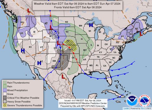
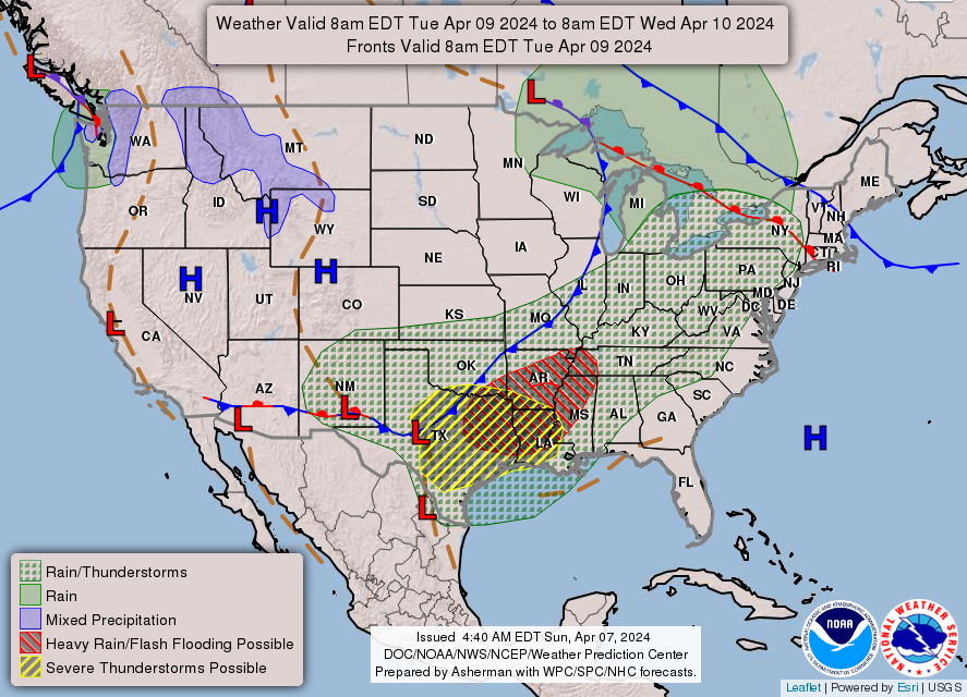
April 2024 General Discussion
in Lakes/Ohio Valley
Posted
Windy off the Lake today as system approaches up to 30-35 mph. Looks like a good rain shield to my south. Messy wx starting later in the evening, but the precip will be welcome.